

Landslide
Encyclopedia
A landslide or landslip is a geological phenomenon which includes a wide range of ground movement, such as rockfall
s, deep failure of slope
s and shallow debris
flows, which can occur in offshore, coastal and onshore environments. Although the action of gravity is the primary driving force for a landslide to occur, there are other contributing factors affecting the original slope stability
. Typically, pre-conditional factors build up specific sub-surface conditions that make the area/slope prone to failure, whereas the actual landslide often requires a trigger before being released.
 Landslides occur when the stability of a slope
changes from a stable to an unstable condition. A change in the stability of a slope can be caused by a number of factors, acting together or alone. Natural causes of landslides include:
Landslides are aggravated by human activities, Human causes include:
 Slope material that becomes saturated
with water may develop into a debris flow
or mud flow
. The resulting slurry of rock
and mud may pick up trees, houses and cars, thus blocking bridges and tributaries causing flooding along its path.
Debris flow is often mistaken for flash flood
, but they are entirely different processes.
Muddy-debris flows in alpine
areas cause severe damage to structures and infrastructure and often claim human lives.
Muddy-debris flows can start as a result of slope-related factors and shallow landslides can dam stream bed
s, resulting in temporary water blockage. As the impoundments fail, a "domino effect" may be created, with a remarkable growth in the volume of the flowing mass, which takes up the debris
in the stream channel. The solid-liquid mixture can reach densities of up to 2 tons/m³ and velocities of up to 14 m/s (Chiarle and Luino, 1998; Arattano, 2003). These processes normally cause the first severe road interruptions, due not only to deposits accumulated on the road (from several cubic metres to hundreds of cubic metres), but in some cases to the complete removal of bridges or roadways or railways crossing the stream channel. Damage usually derives from a common underestimation of mud-debris flows: in the alpine valleys, for example, bridges are frequently destroyed by the impact force of the flow because their span is usually calculated only for a water discharge. For a small basin in the Italian Alps (area = 1.76 km²) affected by a debris flow, Chiarle and Luino (1998) estimated a peak discharge of 750 m3/s for a section located in the middle stretch of the main channel. At the same cross section, the maximum foreseeable water discharge (by HEC-1), was 19 m³/s, a value about 40 times lower than that calculated for the debris flow that occurred.
s are downslope, viscous flows of saturated, fine-grained materials, which move at any speed from slow to fast. Typically, they can move at speeds from 0.17 to 20 km/h. Though these are a lot like mudflow
s, overall they are slower moving and are covered with solid material carried along by flow from within. They are different from fluid flows in that they are more rapid. Clay, fine sand and silt, and fine-grained, pyroclastic material are all susceptible to earthflows. The velocity of the earthflow is all dependent on how much water content is in the flow itself: if there is more water content in the flow, the higher the velocity will be.
These flows usually begin when the pore pressures in a fine-grained mass increase until enough of the weight of the material is supported by pore water to significantly decrease the internal shearing strength of the material. This thereby creates a bulging lobe which advances with a slow, rolling motion. As these lobes spread out, drainage of the mass increases and the margins dry out, thereby lowering the overall velocity of the flow. This process causes the flow to thicken. The bulbous variety of earthflows are not that spectacular, but they are much more common than their rapid counterparts. They develop a sag at their heads and are usually derived from the slumping at the source.
Earthflows occur much more during periods of high precipitation, which saturates the ground and adds water to the slope content. Fissures develop during the movement of clay-like material creates the intrusion of water into the earthflows. Water then increases the pore-water pressure and reduces the shearing strength of the material.
Movement
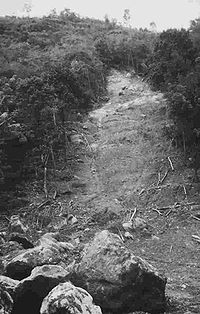
Debris slides generally start with big rocks that start at the top of the slide and begin to break apart as they slide towards the bottom. This is much slower than a debris avalanche. Debris avalanches are very fast and the entire mass seems to liquefy as it slides down the slope. This is caused by a combination of saturated material, and steep slopes. As the debris moves down the slope it generally follows stream channels leaving a v-shaped scar as it moves down the hill. This differs from the more U-shaped scar of a slump. Debris avalanches can also travel well past the foot of the slope due to their tremendous speed.
is a rare, poorly understood type of landslide, typically with a long run-out. Often very large, these slides are unusually mobile, flowing very far over a low angle, flat, or even slightly uphill terrain.
mantle or weathered
bedrock
(typically to a depth from few decimetres to some metres). They usually include debris slides, debris flow
, and failures of road cut-slopes. Landslides occurring as single large blocks of rock moving slowly down slope are sometimes called block glides.
Shallow landslides can often happen in areas that have slopes with high permeable soils on top of low permeable bottom soils. The low permeable, bottom soils trap the water in the shallower, high permeable soils creating high water pressure in the top soils. As the top soils are filled with water and become heavy, slopes can become very unstable and slide over the low permeable bottom soils. Say there is a slope with silt and sand as its top soil and bedrock as its bottom soil. During an intense rainstorm, the bedrock will keep the rain trapped in the top soils of silt and sand. As the topsoil becomes saturated and heavy, it can start to slide over the bedrock and become a shallow landslide.
R. H. Campbell did a study on shallow landslides on Santa Cruz Island California. He notes that if permeability decreases with depth, a perched water table may develop in soils at intense precipitation. When pore water pressure
s are sufficient to reduce effective normal stress to a critical level, failure occurs.
 Landslides in which the sliding surface is mostly deeply located below the maximum rooting depth of trees (typically to depths greater than ten meters). Deep-seated landslides usually involve deep regolith
, weathered rock, and/or bedrock
and include large slope failure associated with translational, rotational, or complex movement. These typically move slowly, only several meters per year, but occasionally move faster. They tend to be larger than shallow landslides and form along a plane of weakness such as a fault or bedding plane. They can be visually identified by concave scarps
at the top and steep areas at the toe.
s. Massive landslides can also generate megatsunami
s, which are usually hundreds of meters high. In 1958, one such tsunami
occurred in Lituya Bay
in Alaska.
 Landslide hazard analysis and mapping can provide useful information for catastrophic loss reduction, and assist in the development of guidelines for sustainable land use planning. The analysis is used to identify the factors that are related to landslides, estimate the relative contribution of factors causing slope failures, establish a relation between the factors and landslides, and to predict the landslide hazard in the future based on such a relationship. The factors that have been used for landslide hazard analysis can usually be grouped into geomorphology
, geology
, land use/land cover, and hydrogeology
. Since many factors are considered for landslide hazard mapping, GIS is an appropriate tool because it has functions of collection, storage, manipulation, display, and analysis of large amounts of spatially referenced data which can be handled fast and effectively. Remote sensing
techniques are also highly employed for landslide hazard assessment and analysis. Before and after aerial photographs and satellite imagery are used to gather landslide characteristics, like distribution and classification, and factors like slope, lithology
, and land use/land cover to be used to help predict future events. Before and after imagery also helps to reveal how the landscape changed after an event, what may have triggered the landslide, and shows the process of regeneration and recovery.
Using satellite imagery in combination with GIS and on-the-ground studies, it is possible to generate maps of likely occurrences of future landslides. Such maps should show the locations of previous events as well as clearly indicate the probable locations of future events. In general, to predict landslides, one must assume that their occurrence is determined by certain geologic factors, and that future landslides will occur under the same conditions as past events. Therefore, it is necessary to establish a relationship between the geomorphologic conditions in which the past events took place and the expected future conditions.
Natural disasters are a dramatic example of people living in conflict with the environment. Early predictions and warnings are essential for the reduction of property damage and loss of life. Because landslides occur frequently and can represent some of the most destructive forces on earth, it is imperative to have a good understanding as to what causes them and how people can either help prevent them from occurring or simply avoid them when they do occur. Sustainable land management and development is an essential key to reducing the negative impacts felt by landslides.
GIS offers a superior method for landslide analysis because it allows one to capture, store, manipulate, analyze, and display large amounts of data quickly and effectively. Because so many variables are involved, it is important to be able to overlay the many layers of data to develop a full and accurate portrayal of what is taking place on the Earth's surface. Researchers need to know which variables are the most important factors that trigger landslides in any given location. Using GIS, extremely detailed maps can be generated to show past events and likely future events which have the potential to save lives, property, and money.
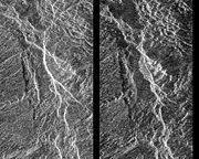 Evidence of past landslides has been detected on many bodies in the solar system, but since most observations are made by probes that only observe for a limited time and most bodies in the solar system appear to be geologically inactive not many landslides are known to have happened in recent times. Both Venus and Mars have been subject to long-term mapping by orbiting satellites, and examples of landslides have been observed on both.
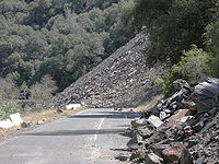
Rockfall
Rockfall or rock-fall refers to quantities of rock falling freely from a cliff face. A rockfall is a fragment of rock detached by sliding, toppling, or falling, that falls along a vertical or sub-vertical cliff, proceeds down slope by bouncing and flying along ballistic trajectories or by rolling...
s, deep failure of slope
Slope
In mathematics, the slope or gradient of a line describes its steepness, incline, or grade. A higher slope value indicates a steeper incline....
s and shallow debris
Debris
Debris is rubble, wreckage, ruins, litter and discarded garbage/refuse/trash, scattered remains of something destroyed, or, in geology, large rock fragments left by a melting glacier etc. The singular form of debris is debris...
flows, which can occur in offshore, coastal and onshore environments. Although the action of gravity is the primary driving force for a landslide to occur, there are other contributing factors affecting the original slope stability
Slope stability
The field of slope stability encompasses the analysis of static and dynamic stability of slopes of earth and rock-fill dams, slopes of other types of embankments, excavated slopes, and natural slopes in soil and soft rock...
. Typically, pre-conditional factors build up specific sub-surface conditions that make the area/slope prone to failure, whereas the actual landslide often requires a trigger before being released.
Causes
Slope stability
The field of slope stability encompasses the analysis of static and dynamic stability of slopes of earth and rock-fill dams, slopes of other types of embankments, excavated slopes, and natural slopes in soil and soft rock...
changes from a stable to an unstable condition. A change in the stability of a slope can be caused by a number of factors, acting together or alone. Natural causes of landslides include:
- groundwaterGroundwaterGroundwater is water located beneath the ground surface in soil pore spaces and in the fractures of rock formations. A unit of rock or an unconsolidated deposit is called an aquifer when it can yield a usable quantity of water. The depth at which soil pore spaces or fractures and voids in rock...
(porewater) pressure acting to destabilize the slope - Loss or absence of vertical vegetative structure, soil nutrients, and soil structureSoil structureSoil structure is determined by how individual soil granules clump or bind together and aggregate, and therefore, the arrangement of soil pores between them...
(e.g. after a wildfireWildfireA wildfire is any uncontrolled fire in combustible vegetation that occurs in the countryside or a wilderness area. Other names such as brush fire, bushfire, forest fire, desert fire, grass fire, hill fire, squirrel fire, vegetation fire, veldfire, and wilkjjofire may be used to describe the same...
) - erosionErosionErosion is when materials are removed from the surface and changed into something else. It only works by hydraulic actions and transport of solids in the natural environment, and leads to the deposition of these materials elsewhere...
of the toe of a slope by rivers or ocean waveWaveIn physics, a wave is a disturbance that travels through space and time, accompanied by the transfer of energy.Waves travel and the wave motion transfers energy from one point to another, often with no permanent displacement of the particles of the medium—that is, with little or no associated mass...
s - weakening of a slope through saturation by snowmelt, glacierGlacierA glacier is a large persistent body of ice that forms where the accumulation of snow exceeds its ablation over many years, often centuries. At least 0.1 km² in area and 50 m thick, but often much larger, a glacier slowly deforms and flows due to stresses induced by its weight...
s melting, or heavy rains - earthquakeEarthquakeAn earthquake is the result of a sudden release of energy in the Earth's crust that creates seismic waves. The seismicity, seismism or seismic activity of an area refers to the frequency, type and size of earthquakes experienced over a period of time...
s adding loads to barely stable slope - earthquake-caused liquefactionSoil liquefactionSoil liquefaction describes a phenomenon whereby a saturated soil substantially loses strength and stiffness in response to an applied stress, usually earthquake shaking or other sudden change in stress condition, causing it to behave like a liquid....
destabilizing slopesHope SlideThe Hope Slide was the largest landslide ever recorded in Canada. It occurred in the morning hours of January 9, 1965 in the Nicolum Valley near Hope, British Columbia, and killed four people... - volcanic eruptionsVolcano2. Bedrock3. Conduit 4. Base5. Sill6. Dike7. Layers of ash emitted by the volcano8. Flank| 9. Layers of lava emitted by the volcano10. Throat11. Parasitic cone12. Lava flow13. Vent14. Crater15...
Landslides are aggravated by human activities, Human causes include:
- deforestationDeforestationDeforestation is the removal of a forest or stand of trees where the land is thereafter converted to a nonforest use. Examples of deforestation include conversion of forestland to farms, ranches, or urban use....
, cultivationTillageTillage is the agricultural preparation of the soil by mechanical agitation of various types, such as digging, stirring, and overturning. Examples of human-powered tilling methods using hand tools include shovelling, picking, mattock work, hoeing, and raking...
and constructionConstructionIn the fields of architecture and civil engineering, construction is a process that consists of the building or assembling of infrastructure. Far from being a single activity, large scale construction is a feat of human multitasking...
, which destabilize the already fragile slopes
- vibrationsOscillationOscillation is the repetitive variation, typically in time, of some measure about a central value or between two or more different states. Familiar examples include a swinging pendulum and AC power. The term vibration is sometimes used more narrowly to mean a mechanical oscillation but sometimes...
from machineMachineA machine manages power to accomplish a task, examples include, a mechanical system, a computing system, an electronic system, and a molecular machine. In common usage, the meaning is that of a device having parts that perform or assist in performing any type of work...
ry or trafficTrafficTraffic on roads may consist of pedestrians, ridden or herded animals, vehicles, streetcars and other conveyances, either singly or together, while using the public way for purposes of travel... - blastingExplosive materialAn explosive material, also called an explosive, is a reactive substance that contains a great amount of potential energy that can produce an explosion if released suddenly, usually accompanied by the production of light, heat, sound, and pressure...
- earthworkEarthworks (engineering)Earthworks are engineering works created through the moving or processing of quantities of soil or unformed rock.- Civil engineering use :Typical earthworks include roads, railway beds, causeways, dams, levees, canals, and berms...
which alters the shape of a slope, or which imposes new loads on an existing slope - in shallow soilSoilSoil is a natural body consisting of layers of mineral constituents of variable thicknesses, which differ from the parent materials in their morphological, physical, chemical, and mineralogical characteristics...
s, the removal of deep-rootRootIn vascular plants, the root is the organ of a plant that typically lies below the surface of the soil. This is not always the case, however, since a root can also be aerial or aerating . Furthermore, a stem normally occurring below ground is not exceptional either...
ed vegetationVegetationVegetation is a general term for the plant life of a region; it refers to the ground cover provided by plants. It is a general term, without specific reference to particular taxa, life forms, structure, spatial extent, or any other specific botanical or geographic characteristics. It is broader...
that binds colluviumColluviumColluvium is the name for loose bodies of sediment that have been deposited or built up at the bottom of a low-grade slope or against a barrier on that slope, transported by gravity. The deposits that collect at the foot of a steep slope or cliff are also known by the same name. Colluvium often...
to bedrockBedrockIn stratigraphy, bedrock is the native consolidated rock underlying the surface of a terrestrial planet, usually the Earth. Above the bedrock is usually an area of broken and weathered unconsolidated rock in the basal subsoil... - Construction, agricultural or forestry activities (logging) which change the amount of water which infiltrates the soil.
Debris flow
Aquifer
An aquifer is a wet underground layer of water-bearing permeable rock or unconsolidated materials from which groundwater can be usefully extracted using a water well. The study of water flow in aquifers and the characterization of aquifers is called hydrogeology...
with water may develop into a debris flow
Debris flow
A debris flow is a fast moving, liquefied landslide of unconsolidated, saturated debris that looks like flowing concrete. It is differentiated from a mudflow in terms of the viscosity and textural properties of the flow. Flows can carry material ranging in size from clay to boulders, and may...
or mud flow
Mudflow
A mudslide is the most rapid and fluid type of downhill mass wasting. It is a rapid movement of a large mass of mud formed from loose soil and water. Similar terms are mudflow, mud stream, debris flow A mudslide is the most rapid (up to 80 km/h, or 50 mph) and fluid type of downhill mass...
. The resulting slurry of rock
Rock (geology)
In geology, rock or stone is a naturally occurring solid aggregate of minerals and/or mineraloids.The Earth's outer solid layer, the lithosphere, is made of rock. In general rocks are of three types, namely, igneous, sedimentary, and metamorphic...
and mud may pick up trees, houses and cars, thus blocking bridges and tributaries causing flooding along its path.
Debris flow is often mistaken for flash flood
Flash flood
A flash flood is a rapid flooding of geomorphic low-lying areas—washes, rivers, dry lakes and basins. It may be caused by heavy rain associated with a storm, hurricane, or tropical storm or meltwater from ice or snow flowing over ice sheets or snowfields...
, but they are entirely different processes.
Muddy-debris flows in alpine
Alpine climate
Alpine climate is the average weather for a region above the tree line. This climate is also referred to as mountain climate or highland climate....
areas cause severe damage to structures and infrastructure and often claim human lives.
Muddy-debris flows can start as a result of slope-related factors and shallow landslides can dam stream bed
Stream bed
A stream bed is the channel bottom of a stream, river or creek; the physical confine of the normal water flow. The lateral confines or channel margins, during all but flood stage, are known as the stream banks or river banks. In fact, a flood occurs when a stream overflows its banks and flows onto...
s, resulting in temporary water blockage. As the impoundments fail, a "domino effect" may be created, with a remarkable growth in the volume of the flowing mass, which takes up the debris
Debris
Debris is rubble, wreckage, ruins, litter and discarded garbage/refuse/trash, scattered remains of something destroyed, or, in geology, large rock fragments left by a melting glacier etc. The singular form of debris is debris...
in the stream channel. The solid-liquid mixture can reach densities of up to 2 tons/m³ and velocities of up to 14 m/s (Chiarle and Luino, 1998; Arattano, 2003). These processes normally cause the first severe road interruptions, due not only to deposits accumulated on the road (from several cubic metres to hundreds of cubic metres), but in some cases to the complete removal of bridges or roadways or railways crossing the stream channel. Damage usually derives from a common underestimation of mud-debris flows: in the alpine valleys, for example, bridges are frequently destroyed by the impact force of the flow because their span is usually calculated only for a water discharge. For a small basin in the Italian Alps (area = 1.76 km²) affected by a debris flow, Chiarle and Luino (1998) estimated a peak discharge of 750 m3/s for a section located in the middle stretch of the main channel. At the same cross section, the maximum foreseeable water discharge (by HEC-1), was 19 m³/s, a value about 40 times lower than that calculated for the debris flow that occurred.
Earth flow
EarthflowEarthflow
An earthflow is a downslope viscous flow of fine grained materials that have been saturated with water, and moves under the pull of gravity. They are an intermediate type of mass wasting that is between downhill creep and mudflow...
s are downslope, viscous flows of saturated, fine-grained materials, which move at any speed from slow to fast. Typically, they can move at speeds from 0.17 to 20 km/h. Though these are a lot like mudflow
Mudflow
A mudslide is the most rapid and fluid type of downhill mass wasting. It is a rapid movement of a large mass of mud formed from loose soil and water. Similar terms are mudflow, mud stream, debris flow A mudslide is the most rapid (up to 80 km/h, or 50 mph) and fluid type of downhill mass...
s, overall they are slower moving and are covered with solid material carried along by flow from within. They are different from fluid flows in that they are more rapid. Clay, fine sand and silt, and fine-grained, pyroclastic material are all susceptible to earthflows. The velocity of the earthflow is all dependent on how much water content is in the flow itself: if there is more water content in the flow, the higher the velocity will be.
These flows usually begin when the pore pressures in a fine-grained mass increase until enough of the weight of the material is supported by pore water to significantly decrease the internal shearing strength of the material. This thereby creates a bulging lobe which advances with a slow, rolling motion. As these lobes spread out, drainage of the mass increases and the margins dry out, thereby lowering the overall velocity of the flow. This process causes the flow to thicken. The bulbous variety of earthflows are not that spectacular, but they are much more common than their rapid counterparts. They develop a sag at their heads and are usually derived from the slumping at the source.
Earthflows occur much more during periods of high precipitation, which saturates the ground and adds water to the slope content. Fissures develop during the movement of clay-like material creates the intrusion of water into the earthflows. Water then increases the pore-water pressure and reduces the shearing strength of the material.
Debris avalanche
A debris avalanche is a type of slide characterized by the chaotic movement of rocks soil and debris mixed with water or ice (or both). They are usually triggered by the saturation of thickly vegetated slopes which results in an incoherent mixture of broken timber, smaller vegetation and other debris. Debris avalanches differ from debris slides because their movement is much more rapid. This is usually a result of lower cohesion or higher water content and commonly steeper slopes.Movement
Debris slides generally start with big rocks that start at the top of the slide and begin to break apart as they slide towards the bottom. This is much slower than a debris avalanche. Debris avalanches are very fast and the entire mass seems to liquefy as it slides down the slope. This is caused by a combination of saturated material, and steep slopes. As the debris moves down the slope it generally follows stream channels leaving a v-shaped scar as it moves down the hill. This differs from the more U-shaped scar of a slump. Debris avalanches can also travel well past the foot of the slope due to their tremendous speed.
Sturzstrom
A sturzstromSturzstrom
A sturzstrom is a rare, unique type of landslide consisting of soil and rock which is characterized by having a great horizontal movement when compared to its initial vertical drop - as much as 20 or 30 times the vertical distance...
is a rare, poorly understood type of landslide, typically with a long run-out. Often very large, these slides are unusually mobile, flowing very far over a low angle, flat, or even slightly uphill terrain.
Shallow landslide
Landslide in which the sliding surface is located within the soilSoil
Soil is a natural body consisting of layers of mineral constituents of variable thicknesses, which differ from the parent materials in their morphological, physical, chemical, and mineralogical characteristics...
mantle or weathered
Weathering
Weathering is the breaking down of rocks, soils and minerals as well as artificial materials through contact with the Earth's atmosphere, biota and waters...
bedrock
Bedrock
In stratigraphy, bedrock is the native consolidated rock underlying the surface of a terrestrial planet, usually the Earth. Above the bedrock is usually an area of broken and weathered unconsolidated rock in the basal subsoil...
(typically to a depth from few decimetres to some metres). They usually include debris slides, debris flow
Debris flow
A debris flow is a fast moving, liquefied landslide of unconsolidated, saturated debris that looks like flowing concrete. It is differentiated from a mudflow in terms of the viscosity and textural properties of the flow. Flows can carry material ranging in size from clay to boulders, and may...
, and failures of road cut-slopes. Landslides occurring as single large blocks of rock moving slowly down slope are sometimes called block glides.
Shallow landslides can often happen in areas that have slopes with high permeable soils on top of low permeable bottom soils. The low permeable, bottom soils trap the water in the shallower, high permeable soils creating high water pressure in the top soils. As the top soils are filled with water and become heavy, slopes can become very unstable and slide over the low permeable bottom soils. Say there is a slope with silt and sand as its top soil and bedrock as its bottom soil. During an intense rainstorm, the bedrock will keep the rain trapped in the top soils of silt and sand. As the topsoil becomes saturated and heavy, it can start to slide over the bedrock and become a shallow landslide.
R. H. Campbell did a study on shallow landslides on Santa Cruz Island California. He notes that if permeability decreases with depth, a perched water table may develop in soils at intense precipitation. When pore water pressure
Pore water pressure
Pore water pressure refers to the pressure of groundwater held within a soil or rock, in gaps between particles . Pore water pressures in below the phreatic level are measured in piezometers...
s are sufficient to reduce effective normal stress to a critical level, failure occurs.
Deep-seated landslide
Regolith
Regolith is a layer of loose, heterogeneous material covering solid rock. It includes dust, soil, broken rock, and other related materials and is present on Earth, the Moon, some asteroids, and other terrestrial planets and moons.-Etymology:...
, weathered rock, and/or bedrock
Bedrock
In stratigraphy, bedrock is the native consolidated rock underlying the surface of a terrestrial planet, usually the Earth. Above the bedrock is usually an area of broken and weathered unconsolidated rock in the basal subsoil...
and include large slope failure associated with translational, rotational, or complex movement. These typically move slowly, only several meters per year, but occasionally move faster. They tend to be larger than shallow landslides and form along a plane of weakness such as a fault or bedding plane. They can be visually identified by concave scarps
Fault scarp
A fault scarp is the topographic expression of faulting attributed to the displacement of the land surface by movement along faults. They are exhibited either by differential movement and subsequent erosion along an old inactive geologic fault , or by a movement on a recent active fault...
at the top and steep areas at the toe.
Causing tsunamis
Landslides that occur undersea, or have impact into water, can generate tsunamiTsunami
A tsunami is a series of water waves caused by the displacement of a large volume of a body of water, typically an ocean or a large lake...
s. Massive landslides can also generate megatsunami
Megatsunami
Megatsunami is an informal term to describe a tsunami that has initial wave heights that are much larger than normal tsunamis...
s, which are usually hundreds of meters high. In 1958, one such tsunami
1958 Lituya Bay megatsunami
The 1958 Lituya Bay megatsunami occurred on July 9, 1958, when an earthquake triggered a landslide that caused 30 million cubic meters of rock and ice to fall into the narrow inlet of Lituya Bay, Alaska...
occurred in Lituya Bay
Lituya Bay
Lituya Bay is a fjord located on the coast of the Southeast part of the U.S. state of Alaska. It is long and wide at its widest point. The bay was noted in 1786 by Jean-François de La Pérouse, who named it Port des Français...
in Alaska.
Related phenomena
- An avalancheAvalancheAn avalanche is a sudden rapid flow of snow down a slope, occurring when either natural triggers or human activity causes a critical escalating transition from the slow equilibrium evolution of the snow pack. Typically occurring in mountainous terrain, an avalanche can mix air and water with the...
, similar in mechanism to a landslide, involves a large amount of ice, snow and rock falling quickly down the side of a mountain. - A pyroclastic flowPyroclastic flowA pyroclastic flow is a fast-moving current of superheated gas and rock , which reaches speeds moving away from a volcano of up to 700 km/h . The flows normally hug the ground and travel downhill, or spread laterally under gravity...
is caused by a collapsing cloud of hot ashVolcanic ashVolcanic ash consists of small tephra, which are bits of pulverized rock and glass created by volcanic eruptions, less than in diameter. There are three mechanisms of volcanic ash formation: gas release under decompression causing magmatic eruptions; thermal contraction from chilling on contact...
, gas and rocks from a volcanic explosion that moves rapidly down an erupting volcanoVolcano2. Bedrock3. Conduit 4. Base5. Sill6. Dike7. Layers of ash emitted by the volcano8. Flank| 9. Layers of lava emitted by the volcano10. Throat11. Parasitic cone12. Lava flow13. Vent14. Crater15...
.
Landslide prediction mapping
Geomorphology
Geomorphology is the scientific study of landforms and the processes that shape them...
, geology
Geology
Geology is the science comprising the study of solid Earth, the rocks of which it is composed, and the processes by which it evolves. Geology gives insight into the history of the Earth, as it provides the primary evidence for plate tectonics, the evolutionary history of life, and past climates...
, land use/land cover, and hydrogeology
Hydrogeology
Hydrogeology is the area of geology that deals with the distribution and movement of groundwater in the soil and rocks of the Earth's crust, . The term geohydrology is often used interchangeably...
. Since many factors are considered for landslide hazard mapping, GIS is an appropriate tool because it has functions of collection, storage, manipulation, display, and analysis of large amounts of spatially referenced data which can be handled fast and effectively. Remote sensing
Remote sensing
Remote sensing is the acquisition of information about an object or phenomenon, without making physical contact with the object. In modern usage, the term generally refers to the use of aerial sensor technologies to detect and classify objects on Earth by means of propagated signals Remote sensing...
techniques are also highly employed for landslide hazard assessment and analysis. Before and after aerial photographs and satellite imagery are used to gather landslide characteristics, like distribution and classification, and factors like slope, lithology
Lithology
The lithology of a rock unit is a description of its physical characteristics visible at outcrop, in hand or core samples or with low magnification microscopy, such as colour, texture, grain size, or composition. It may be either a detailed description of these characteristics or be a summary of...
, and land use/land cover to be used to help predict future events. Before and after imagery also helps to reveal how the landscape changed after an event, what may have triggered the landslide, and shows the process of regeneration and recovery.
Using satellite imagery in combination with GIS and on-the-ground studies, it is possible to generate maps of likely occurrences of future landslides. Such maps should show the locations of previous events as well as clearly indicate the probable locations of future events. In general, to predict landslides, one must assume that their occurrence is determined by certain geologic factors, and that future landslides will occur under the same conditions as past events. Therefore, it is necessary to establish a relationship between the geomorphologic conditions in which the past events took place and the expected future conditions.
Natural disasters are a dramatic example of people living in conflict with the environment. Early predictions and warnings are essential for the reduction of property damage and loss of life. Because landslides occur frequently and can represent some of the most destructive forces on earth, it is imperative to have a good understanding as to what causes them and how people can either help prevent them from occurring or simply avoid them when they do occur. Sustainable land management and development is an essential key to reducing the negative impacts felt by landslides.
GIS offers a superior method for landslide analysis because it allows one to capture, store, manipulate, analyze, and display large amounts of data quickly and effectively. Because so many variables are involved, it is important to be able to overlay the many layers of data to develop a full and accurate portrayal of what is taking place on the Earth's surface. Researchers need to know which variables are the most important factors that trigger landslides in any given location. Using GIS, extremely detailed maps can be generated to show past events and likely future events which have the potential to save lives, property, and money.
Prehistoric landslides
- Landslide which moved Heart MountainHeart Mountain (Wyoming)Heart Mountain is an 8,123-foot klippe just north of Cody in the U.S. state of Wyoming, sticking up from the floor of the Bighorn Basin...
to its current location, the largest ever discovered on land. In the 48 million years since the slide occurred, erosion has removed most of the portion of the slide. - Flims RockslideFlims RockslideFlims Rockslide occurred some 10000 years ago. It is known as the biggest Landslide incident in the Alps and the biggest worldwide whose effects are still visible, moving some of rock, about 300 times that of the historic Swiss Goldau landslide. The town of Flims can be found at the line where...
, ca. 13000 km³ (3,118.9 cu mi), Switzerland, some 10000 years ago in post-glacial PleistocenePleistoceneThe Pleistocene is the epoch from 2,588,000 to 11,700 years BP that spans the world's recent period of repeated glaciations. The name pleistocene is derived from the Greek and ....
/HoloceneHoloceneThe Holocene is a geological epoch which began at the end of the Pleistocene and continues to the present. The Holocene is part of the Quaternary period. Its name comes from the Greek words and , meaning "entirely recent"...
, the largest so far described in the alps and on dry land that can be easily identified in a modestly eroded state. - The landslide around 200BC which formed Lake WaikaremoanaLake WaikaremoanaLake Waikaremoana is located in Te Urewera National Park in the North Island of New Zealand, 60 kilometres northwest of Wairoa and 80 kilometres southwest of Gisborne. It covers an area of 54 km². From the Maori Waikaremoana translates as 'sea of rippling waters'The lake lies in the heart of Tuhoe...
on the North IslandNorth IslandThe North Island is one of the two main islands of New Zealand, separated from the much less populous South Island by Cook Strait. The island is in area, making it the world's 14th-largest island...
of New Zealand, where a large block of the Ngamoko Range slid and dammed a gorge of Waikaretaheke River, forming a natural reservoir up to 248 metres deep. - Cheekye FanCheekye FanThe Cheekye Fan is a large landslide feature in southwestern British Columbia, Canada, located at the head of Howe Sound. It formed as a result of collapse on the western flank of Mount Garibaldi when the volcano was constructed on top of a glacier during the Late Pleistocene period....
, British ColumbiaBritish ColumbiaBritish Columbia is the westernmost of Canada's provinces and is known for its natural beauty, as reflected in its Latin motto, Splendor sine occasu . Its name was chosen by Queen Victoria in 1858...
, Canada, ca. 25 square kilometre, Late PleistoceneLate PleistoceneThe Late Pleistocene is a stage of the Pleistocene Epoch. The beginning of the stage is defined by the base of the Eemian interglacial phase before the final glacial episode of the Pleistocene 126,000 ± 5,000 years ago. The end of the stage is defined exactly at 10,000 Carbon-14 years BP...
in age.
Prehistoric submarine landslides
- The Storegga SlideStoregga SlideThe three Storegga Slides are considered to be amongst the largest known landslides. They occurred under water, at the edge of Norway's continental shelf , in the Norwegian Sea, 100 km north-west of the Møre coast, causing a very large tsunami in the North Atlantic Ocean...
, Norway, ca. 3500 km³ (839.7 cu mi), ca. 8,000 years ago, a catastrophic impact on the contemporary coastal Mesolithic population - The Agulhas slide, ca. 20000 km³ (4,798.3 cu mi), off South Africa, post-PliocenePlioceneThe Pliocene Epoch is the period in the geologic timescale that extends from 5.332 million to 2.588 million years before present. It is the second and youngest epoch of the Neogene Period in the Cenozoic Era. The Pliocene follows the Miocene Epoch and is followed by the Pleistocene Epoch...
in age, the largest so far described - The Ruatoria Debris Avalanche, off North IslandNorth IslandThe North Island is one of the two main islands of New Zealand, separated from the much less populous South Island by Cook Strait. The island is in area, making it the world's 14th-largest island...
New Zealand, ca. 3,000 km³ in volume, 170,000 years ago.
Historical landslides
- The Goldau on September 2, 1806
- The Cap Diamant Québec rockslideQuebec rockslideThe Quebec rockslide occurred on September 19, 1889, after a day of heavy rain in Quebec City, Canada. An overhanging piece of slate rock broke off from Cap Diamant and fell 90 metres onto the houses below. The homes of 28 families on Champlain Street were crushed, burying roughly 100 people...
on September 19, 1889 - Frank SlideFrank SlideThe Frank Slide is a natural landslide feature in the southern Rocky Mountains of Canada, and a significant historical event in western Canada.Frank, Alberta is a coal mining town in the Crowsnest Pass, Alberta...
, Turtle Mountain, AlbertaAlbertaAlberta is a province of Canada. It had an estimated population of 3.7 million in 2010 making it the most populous of Canada's three prairie provinces...
, Canada, on 29 April 1903 - Khait landslideKhait landslideThe Khait or Hoit landslide occurred on July 10, 1949 in the Hoit district in the Gharm Oblast in the Tajikistan, then part of the Soviet Union. The landslide was triggered by the 1949 Khait earthquake and buried 33 villages and has by some estimates killed 28,000 people...
, Khait, Tajikistan, Soviet Union, on July 10, 1949 - Monte TocMonte TocMonte Toc is a mountain on the border between Veneto and Friuli-Venezia Giulia in Northern Italy best known for the Vajont Dam, which was built at the mountain's base in 1960....
landslide (260 millions cubic metres) falling into the Vajont DamVajont DamThe Vajont Dam is a disused dam, completed in 1959 in the valley of the Vajont river under Monte Toc, 100 km north of Venice, Italy...
basin in Italy, causing a megatsunamiMegatsunamiMegatsunami is an informal term to describe a tsunami that has initial wave heights that are much larger than normal tsunamis...
and about 2000 casualties, on October 9, 1963 - Hope SlideHope SlideThe Hope Slide was the largest landslide ever recorded in Canada. It occurred in the morning hours of January 9, 1965 in the Nicolum Valley near Hope, British Columbia, and killed four people...
landslide (46 million cubic metres) near Hope, British ColumbiaHope, British ColumbiaHope is a district municipality located at the confluence of the Fraser and Coquihalla rivers in the province of British Columbia, Canada. Hope is at the eastern end of both the Fraser Valley and the Lower Mainland region, and is at the southern end of the Fraser Canyon...
on January 9, 1965. - The 1966 Aberfan disaster
- Tuve landslideTuve landslideThe Tuve landslide was a large landslide in Tuve, Gothenburg, Sweden on November 30, 1977. Some 67 houses were destroyed, killing 9, injuring about 60 and making around 600 people homeless. The slide began at 16.05 and lasted 5–6 minutes. The slide affected 270 000 square meters...
in GothenburgGothenburgGothenburg is the second-largest city in Sweden and the fifth-largest in the Nordic countries. Situated on the west coast of Sweden, the city proper has a population of 519,399, with 549,839 in the urban area and total of 937,015 inhabitants in the metropolitan area...
, Sweden on November 30, 1977. - The 1979 Abbotsford landslip1979 Abbotsford landslipOn 8 August 1979, a major landslip occurred in the Dunedin, New Zealand suburb of Abbotsford. It was the largest landslide in a built-up area in New Zealand's history, resulting in the destruction of 69 houses - around one sixth of the suburb - but no fatalities.-Geography:The suburb of Abbotsford...
, DunedinDunedinDunedin is the second-largest city in the South Island of New Zealand, and the principal city of the Otago Region. It is considered to be one of the four main urban centres of New Zealand for historic, cultural, and geographic reasons. Dunedin was the largest city by territorial land area until...
, New Zealand on August 8, 1979. - Val Pola landslideVal Pola landslideThe Val Pola landslide happened in Valtellina, Lombardy, Northern Italian Alps, on July 28, 1987 and resulted in the Valtellina disaster with the total cost of 400 million euros...
during Valtellina disasterValtellina disasterThe Valtellina disaster happened in Valtellina, Northern Italian Alps, in July-August 1987. The calamity affected the provinces of Sondrio, Brescia, Bergamo, Lecco, and Como....
(1987) Italy - Thredbo landslide1997 Thredbo landslideThe Thredbo landslide was a catastrophic landslide that occurred at the village and ski resort of Thredbo, New South Wales, Australia, on 30 July 1997. Two ski lodges were destroyed, and a total of 18 died.- Landslide :...
, Australia on 30 July 1997, destroyed hostel. - Vargas mudslides, due to heavy rains in Vargas State, VenezuelaVenezuelaVenezuela , officially called the Bolivarian Republic of Venezuela , is a tropical country on the northern coast of South America. It borders Colombia to the west, Guyana to the east, and Brazil to the south...
, on December, 1999, causing tens of thousands of casualties. - 2007 Chittagong mudslide2007 Chittagong mudslideThe 2007 Chittagong mudslides occurred in the port city of Chittagong in south-eastern Bangladesh. On 11 June 2007, heavy monsoon rainfall caused landslides that engulfed slums around the hilly areas of the city...
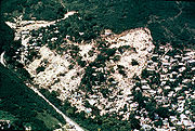
, in ChittagongChittagongChittagong ) is a city in southeastern Bangladesh and the capital of an eponymous district and division. Built on the banks of the Karnaphuli River, the city is home to Bangladesh's busiest seaport and has a population of over 4.5 million, making it the second largest city in the country.A trading...
, BangladeshBangladeshBangladesh , officially the People's Republic of Bangladesh is a sovereign state located in South Asia. It is bordered by India on all sides except for a small border with Burma to the far southeast and by the Bay of Bengal to the south...
, on June 11, 2007. - 2008 Cairo landslide2008 Cairo landslideThe 2008 Cairo landslide happened on September 6, 2008, in Al-Duwayqa, an informal settlement in the Manshiyet Nasser neighborhood of east Cairo, Egypt. 119 people died in the rockslide....
on September 6, 2008. - The 2010 Uganda landslide caused over 100 deaths following heavy rain in BududaBududa DistrictBududa District is a district in Eastern Uganda. Like most other Ugandan districts, it is named after its 'chief town', Bududa.-Location:Bududa District is bordered by Sironko District to the north, the Republic of Kenya to the east, Manafwa District to the south and Mbale District to the west...
region. - Zhouqu county mudslide2010 Gansu mudslideThe 2010 Gansu mudslide was a deadly mudslide in Zhugqu County in Gannan TAP in China that occurred at 12 midnight on 8 August 2010. It was caused by heavy rainfall and flooding in Gansu Province. It was the most deadly individual disaster among the 2010 China floods . The mudslides killed more...
in GansuGansu' is a province located in the northwest of the People's Republic of China.It lies between the Tibetan and Huangtu plateaus, and borders Mongolia, Inner Mongolia, and Ningxia to the north, Xinjiang and Qinghai to the west, Sichuan to the south, and Shaanxi to the east...
, China on August 8, 2010. - Devil's Slide, an ongoing landslide in San Mateo County, CaliforniaSan Mateo County, CaliforniaSan Mateo County is a county located in the San Francisco Bay Area of the U.S. state of California. It covers most of the San Francisco Peninsula just south of San Francisco, and north of Santa Clara County. San Francisco International Airport is located at the northern end of the county, and...
- 2011 Rio de Janeiro landslideJanuary 2011 Rio de Janeiro floods and mudslidesA series of floods and mudslides took place in in several towns of the Mountainous Region , in the Brazilian state of Rio de Janeiro. Casualties occurred in the cities of Nova Friburgo, Teresópolis, Petrópolis, Sumidouro and São José do Vale do Rio Preto. The floods caused at least 903 deaths,...
in Rio de Janeiro, Brazil on January 11, 2011, causing 610 casualties so far.
Extraterrestrial landslides
See also
- Automatic Deformation Monitoring SystemAutomatic Deformation Monitoring SystemAn automatic deformation monitoring system is a group of interacting, interrelated, or interdependent software and hardware elements forming a complex whole for deformation monitoring that, once set up, does not require human input to function. Automatic deformation monitoring systems provide a...
- Deformation monitoringDeformation monitoringDeformation monitoring is the systematic measurement and tracking of the alteration in the shape or dimensions of an object as a result of stresses induced by applied loads...
- Earthquake engineeringEarthquake engineeringEarthquake engineering is the scientific field concerned with protecting society, the natural and the man-made environment from earthquakes by limiting the seismic risk to socio-economically acceptable levels...
- GeotechnicsGeotechnicsGeotechnics is the application of scientific methods and engineering principles to the acquisition, interpretation, and use of knowledge of materials of the Earth's crust and earth materials for the solution of engineering problems...
- Geotechnical engineeringGeotechnical engineeringGeotechnical engineering is the branch of civil engineering concerned with the engineering behavior of earth materials. Geotechnical engineering is important in civil engineering, but is also used by military, mining, petroleum, or any other engineering concerned with construction on or in the ground...
- Landslide damLandslide damA landslide dam, debris dam, or barrier lake is a natural damming of a river by some kind of mass wasting: landslide, debris flow, rock avalanche or volcano. If it is caused by earthquake, it may also be called a quake lake. Some landslide dams are as high as the largest existing artificial dam...
- Landslide mitigationLandslide mitigationLandslide mitigation refers to lessen the effect of landslides by constructing various man made projects at the slopes which are vulnerable to landslides planning for landslides hazard mitigation as its phenomenon is instant. Landslides can be triggered by many often concomitant causes...
- Mass wastingMass wastingMass wasting, also known as slope movement or mass movement, is the geomorphic process by which soil, regolith, and rock move downslope under the force of gravity. Types of mass wasting include creep, slides, flows, topples, and falls, each with its own characteristic features, and taking place...
- Slope stabilitySlope stabilityThe field of slope stability encompasses the analysis of static and dynamic stability of slopes of earth and rock-fill dams, slopes of other types of embankments, excavated slopes, and natural slopes in soil and soft rock...
- SturzstromSturzstromA sturzstrom is a rare, unique type of landslide consisting of soil and rock which is characterized by having a great horizontal movement when compared to its initial vertical drop - as much as 20 or 30 times the vertical distance...
- Submarine landslideSubmarine landslideSubmarine landslides are marine landslides that transport sediment across the continental shelf and into the deep ocean. A submarine landslide is initiated when the downwards driving stress exceeds the resisting stress of the seafloor slope material causing movements along one or more concave to...
- WashawayWashawayA washaway is a particular kind of landslide that can affect man-made structures such as cuttings, embankments and bridges. They are thus a hazard to railways and road traffic.- Overview :...
- Mudslide
- California landslidesCalifornia landslidesLandslides in California occur mainly due to the dynamic tectonics along the San Andreas Fault Line. Southern California proves to be a particularly active tectonic area, and also a common place for residential development.-California Geological Survey:...
External links
- United States Geological Survey site
- British Geological Survey landslides site
- British Geological Survey National Landslide Database
- European Soil Portal, Landslides
- British Columbia government landslide information
- Slide!, a program on B.C.'s Knowledge Network, with video clips
- Pictures of Slope Failure
- JTC1 Joint International Technical Committee on Landslides and Engineered Slopes
- Landslide blog written by Professor David Petley, Wilson Professor, Department of Geography, Durham University, UK