

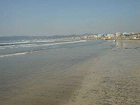
Yuigahama
Encyclopedia
Kamakura, Kanagawa
is a city located in Kanagawa Prefecture, Japan, about south-south-west of Tokyo. It used to be also called .Although Kamakura proper is today rather small, it is often described in history books as a former de facto capital of Japan as the seat of the Shogunate and of the Regency during the...
, a city in Kanagawa Prefecture, Japan
Japan
Japan is an island nation in East Asia. Located in the Pacific Ocean, it lies to the east of the Sea of Japan, China, North Korea, South Korea and Russia, stretching from the Sea of Okhotsk in the north to the East China Sea and Taiwan in the south...
. The relation between the beach and its neighboring areas is complex. Although Yuigahama is in fact the entire 3.2 km beach that goes from Inamuragasaki
Inamuragasaki
is a cape at the western end of Yuigahama in Kamakura, Kanagawa Prefecture, Japan. The cape divides Yuigahama from Shichirigahama and Enoshima. Its name seems to stem from its shape, similar to a stack of rice at harvest time...
, which separates it from Shichirigahama
Shichirigahama
is a beach near Kamakura, Kanagawa prefecture, Japan, which goes from Koyurigimisaki Cape, near Fujisawa, to Inamuragasaki Cape, west of Kamakura. Since one could enjoy a clear view of Mount Fuji and Enoshima from there, during the Edo period it was famous as a subject for ukiyo-e. For example,...
, to Zaimokuza
Zaimokuza
is an area within the Kamakura, Kanagawa Pref., in Japan that runs along the sea from Cape Iijima near Kotsubo harbor to the estuary of the Namerigawa. The relation between the beach's name and that of its neighboring areas is complex...
's Iijima cape, which separates it from Kotsubo
Kotsubo
Kotsubo is a small fishing village in Zushi, Kanagawa Prefecture, Japan. It is half way between Zushi and the old Japanese capital of Kamakura...
and the Miura Peninsula
Miura Peninsula
is a peninsula located in Kanagawa, Japan. It lies south of Yokohama and Tokyo and divides Tokyo Bay, to the east, from Sagami Bay, to the west. Cities and towns on the Miura Peninsula include Yokosuka, Miura, Hayama, Zushi, and Kamakura....
, the name is customarily used to indicate just its half west of the Namerigawa
Namerigawa, Kanagawa
The is a river that goes from the Asaina Pass in northern Kamakura, Kanagawa to the beach in Yuigahama, for a total length of about 8 km. Although Yuigahama is in fact the name of the entire 3.2 km beach that goes from Inamuragasaki to Zaimokuza's Iijima cape, the name is usually used just for its...
river, while the eastern half is called . This is the reason why, although the beach gives its name to only the west part of the beachside community, traces of the name Yuigahama can be found also in Zaimokuza (for example in Moto Hachiman
Moto Hachiman
is a small but very old and historically important Shinto shrine in Kamakura, Kanagawa Pref., Japan.-History:Although officially called , this tiny shrine in Zaimokuza is universally known as Moto Hachiman , and in front of its torii stands a stele with the words...
's official name, Yui Wakamiya). The center of Yuigahama came legally into being between 1964 and 1965 and was named after the beach. Today's Yuigahama was until then divided between Zaimokuza, Ōmachi
Omachi
Ōmachi may refer to:* Ōmachi, Nagano , a city* Ōmachi, Saga , a town* Ōmachi , a district in the city of Kamakura...
, and Hase
Hase
The Hase is a 193 km long river in Lower Saxony, Germany. It is a right tributary of the Ems, but part of its flow goes to the Else, that is part of the Weser basin. Its source is in the Teutoburg Forest, south-east of Osnabrück, on the north slope of the 307 m high Hankenüll hill.- Weser-Ems...
.
There are different theories about the origin of the name. According to one it derives from an earlier one, . According to another it derives from the presence of a cooperative . The name Yui itself has been written in various ways, among them 由井 and 湯井.
Yuigahama at the time of the shogunate
During the Kamakura periodKamakura period
The is a period of Japanese history that marks the governance by the Kamakura Shogunate, officially established in 1192 in Kamakura by the first shogun Minamoto no Yoritomo....
both the beach and the nearby areas were called . The name appears repeatedly in the Azuma Kagami
Azuma Kagami
The , or "mirror of the east", is a Japanese medieval text that chronicles events of the Kamakura Shogunate from Minamoto no Yoritomo's rebellion against the Taira clan in Izokuni of 1180 to Munetaka Shinnō and his return to Kyoto in 1266...
to indicate spots going from Hase to Wakamiya Oji
Wakamiya Oji
is a 1.8 km street in Kamakura, a city in Kanagawa Prefecture in Japan, unusual because it is at the same time the city's main avenue and the approach of its largest Shinto shrine, Tsurugaoka Hachiman-gū. Over the centuries Wakamiya Ōji has gone thorough an extreme change. A heavily...
. It was used to practice martial arts such as (horseback archery) and yabusame
Yabusame
is a type of mounted archery in traditional Japanese archery. An archer on a running horse shoots three special "turnip-headed" arrows successively at three wooden targets....
(a horseback archery competition). It became a battlefield in 1180 at the time of the battle against Hatakeyama Shigetada
Hatakeyama Shigetada
was a samurai who fought in the Genpei War, in Japan. Originally fighting for the Taira clan, he switched sides for the battle of Dan-no-ura, and ended the war on the winning side....
, and again in 1333 for the fight between Nitta Yoshisada
Nitta Yoshisada
was the head of the Nitta family in the early fourteenth century, and supported the Southern Court of Emperor Go-Daigo in the Nanboku-chō period, capturing Kamakura from the Hōjō clan in 1333....
and the defense forces of the Hōjō
Hojo
Hōjō may refer to:*Hōjō clan, a family of regents of the Kamakura Shogunate*Late Hōjō clan, daimyo in the Sengoku Period*Hōjō, Ehime, a city in Japan*Hōjō, one of the five kata of Kashima Shinden Jikishinkage-ryū...
. Lastly, it became a battleground in 1416 during Uesugi Zenshū
Uesugi Zenshu
, also known as Uesugi Ujinori, was the chief advisor to Ashikaga Mochiuji, an enemy of the Ashikaga shogunate in feudal Japan. When he was rebuked by Mochiuji in 1415, and forced to resign, Zenshū organized a rebellion....
's rebellion. Human bones of the era are still occasionally found during excavations. It is on this beach that Nichiren
Nichiren
Nichiren was a Buddhist monk who lived during the Kamakura period in Japan. Nichiren taught devotion to the Lotus Sutra, entitled Myōhō-Renge-Kyō in Japanese, as the exclusive means to attain enlightenment and the chanting of Nam-Myōhō-Renge-Kyō as the essential practice of the teaching...
, the founder of the Buddhist Nichiren sect, was put on a boat to be taken to Katase
Katase
Katase is a village in Alajõe Parish, Ida-Viru County, in northeastern Estonia. It's located on the northern shore of Lake Peipus. Katase has a population of 75 .Katase was first mentioned in 1419....
and executed.
The beach was considered ground sacred to the Minamoto and, before visiting shrines in Izu
Izu
Izu may refer to:*Izu Province, a part of modern-day Shizuoka prefecture in Japan**Izu, a city in Shizuoka prefecture**The Izu Peninsula, near Tokyo***The Izu Islands, located off the Izu Peninsula...
or Hakone, the shogun would always purify his body here.
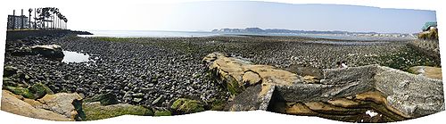
Wakaejima
During the Kamakura Shogunate
Kamakura shogunate
The Kamakura shogunate was a military dictatorship in Japan headed by the shoguns from 1185 to 1333. It was based in Kamakura. The Kamakura period draws its name from the capital of the shogunate...
Sagami Bay
Sagami Bay
Sagami Bay , also known as the Sagami Gulf or Sagami Sea, lies south of Kanagawa Prefecture in Honshū, central Japan, contained within the scope of the Miura Peninsula, in Kanagawa, to the east, the Izu Peninsula, in Shizuoka Prefecture, to the west, and the Shōnan coastline to the north, while the...
was busy with trading ships, but its shallowness made indispensable the use of barges. Also, accidents between ships were common and it was therefore decided to build a port. A priest named applied for permission from the Shogunate to build an artificial port in the area, permission granted in 1232. Much of the timber used to build Kamakura's best shrines passed arrived at Miyakejima.
In its first form, the harbor functioned as both a breakwater and a wharf, and was built with large stones laid as a foundation, with smaller stones on top. It was later extended gradually and repaired several times until the end of the Edo Period
Edo period
The , or , is a division of Japanese history which was ruled by the shoguns of the Tokugawa family, running from 1603 to 1868. The political entity of this period was the Tokugawa shogunate....
, when it was abandoned.