

Chesapeake Bay
Encyclopedia
The Chesapeake Bay is the largest estuary
in the United States
. It lies off the Atlantic Ocean
, surrounded by Maryland
and Virginia
. The Chesapeake Bay's drainage basin
covers 64299 square miles (166,534 km²) in the District of Columbia and parts of six states: New York
, Pennsylvania
, Delaware
, Maryland
, Virginia
, and West Virginia
. More than 150 rivers and streams drain into the bay.
The Chesapeake Bay is approximately 200 miles (300 km) long, from the Susquehanna River
in the north to the Atlantic Ocean
in the south. At its narrowest point between Kent County's
Plum Point (near Newtown) and the Harford County
shore near Romney Creek, the bay is 2.8 miles (4.5 km) wide; at its widest point, just south of the mouth of the Potomac River
, it is 30 miles (50 km) wide. Total shoreline for the bay and its tributaries is 11,684 miles (18,804 km), and the surface area of the bay and its major tributaries is 4479 square miles (11,601 km²). Average depth of the bay is 46 feet (14 m) and the maximum depth is 208 feet (63.4 m).
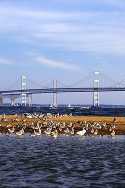
The bay is spanned in two places. The Chesapeake Bay Bridge
crosses the bay in Maryland from Sandy Point
(near Annapolis) to Kent Island
; and the Chesapeake Bay Bridge-Tunnel
in Virginia connects Virginia Beach
to Cape Charles
. The bay has environmental issues but is noted for its beauty; in recent years, a pattern has been that it is becoming "emptier", with fewer crabs, oysters, and watermen.
word referring to a village "at a big river." It is the seventh oldest surviving English place-name in the U.S., first applied as "Chesepiook" by explorers heading north from the Roanoke Colony
into a Chesapeake tributary in 1585 or 1586. In 2005, Algonquian linguist Blair Rudes "helped to dispel one of the area's most widely held beliefs: that 'Chesapeake' means something like 'Great Shellfish Bay.' It does not, Rudes said. The name might actually mean something like 'Great Water,' or it might have been just a village at the bay's mouth."
, or drowned valley, of the Susquehanna, meaning that it was where the river flowed when the sea level was lower. It is not a fjord
, as the Laurentide Ice Sheet
never reached as far south as the northernmost point on the bay.
The bay's geology, its present form, and its very location were created by a bolide impact event
at the end of the Eocene
(about 35.5 million years ago), forming the Chesapeake Bay impact crater
and the Susquehanna River valley much later. The bay was formed starting about 10,000 years ago when rising sea levels at the end of the last ice age flooded the Susquehanna River valley. Parts of the bay, especially the Calvert County, Maryland
, coastline, are lined by cliffs composed of deposits from receding waters millions of years ago. These cliffs, generally known as Calvert Cliffs
, are famous for their fossils, especially fossilized shark
teeth which are commonly found washed up on the beaches next to the cliffs. Scientists' Cliffs
is a beach community in Calvert County named for the desire to create a retreat for scientists when the community was founded in 1935.
Much of the bay is quite shallow. At the point where the Susquehanna River flows into the bay, the average depth is 30 feet (9 m), although this soon diminishes to an average of 10 feet (3 m) from the city of Havre de Grace for about 35 miles (56 km), to just north of Annapolis. On average, the depth of the bay is 21 feet (7 m), including tributaries; over 24% of the bay is less than 6 ft (2 m) deep.
The climate of the area surrounding the bay is primarily humid subtropical, with hot, very humid summers and cold to mild winters. Only the area around the mouth of the Susquehanna River is continental in nature, and the mouth of the Susquehanna River and the Susquehanna flats
often freeze in winter. It is rare for the surface of the bay to freeze in winter, which happened most recently in the winter of 1976–77.
 Since the bay is an estuary, it has fresh water, salt water and brackish water. Brackish water has three salinity
zones — oligohaline, mesohaline, and polyhaline
. The fresh water zone runs from the mouth of the Susquehanna River to north Baltimore. The oligohaline zone has very little salt. Salinity varies from 0.5 ppt to 10 ppt, and freshwater species can survive there. The north end of the oligohaline zone is north Baltimore and the south end is the Chesapeake Bay Bridge. The mesohaline zone has a medium amount of salt and runs from the Bay Bridge to the mouth of the Rappahannock River
. Salinity there ranges from 10.7 ppt to 18 ppt. The polyhaline zone is the saltiest zone, and some of the water can be as salty as sea water. It runs from the mouth of the Rappahannock River to the mouth of the bay. The salinity ranges from 18.7 ppt to 36 ppt. (36 ppt is as salty as the ocean.)
sent an expedition out from Hispaniola
in 1525 which reached the mouths of the Chesapeake and Delaware Bay
s. It may have been the first European expedition to explore parts of the Chesapeake Bay, which the Spaniards called "Bahía de Santa María" or "Bahía de Madre de Dios." De Ayllón established a short-lived Spanish
mission settlement, San Miguel de Gualdape
, in 1526 along the Atlantic coast. Many scholars doubt the assertion that it was as far north as the Chesapeake; most place it in present-day Georgia
's Sapelo Island
. In 1573, governor of Spanish Florida, Pedro Menéndez de Márquez
conducted further exploration of the Chesapeake.
Captain John Smith of England explored and mapped the bay between 1607 and 1609. Smith wrote in his journal:
There was a mass migration of southern English cavaliers and their Irish and Scottish servants to the Chesapeake Bay region between 1640 and 1675. The "Captain John Smith Chesapeake National Historic Trail
", the United States' first all-water National Historic Trail
, was created in July 2006.
The Chesapeake Bay was the site of the Battle of the Chesapeake
in 1781, during which the French fleet defeated the Royal Navy
in the decisive naval battle of the American Revolutionary War
. In the War of 1812
, British warships attacked Fort McHenry
at one point; in a separate attack, British troops sailed up the Chesapeake, landed on the west side near Washington D.C., and trekked overland to burn the capital
. There were so-called Oyster Wars
in the late nineteenth and early twentieth centuries.
During the Great Depression
in the 1930s, catching and eating oysters continued to be popular.
Today, the Calvert Cliffs Nuclear Power Plant
uses water from the bay to cool its reactor.
The bay is known for the Chesapeake Bay Retriever
, a dog breed
developed in this area. The Chesapeake Bay Bridge-Tunnel was built, connecting Virginia's eastern shore with its mainland and is approximately 20 miles (32.2 km) long; it has trestle bridges as well as two stretches of two-mile (3 km)-long tunnels which allow unimpeded shipping; the bridge is supported by four 5.25 acres (21,246 m²) man-made islands.
and numerous shellfish
and crab
species. Some of these include the Atlantic menhaden
, Striped bass
, American eel
, Eastern oyster
, and the Blue crab.
Bird predators include the American Osprey
, Great Blue Heron
, the Bald Eagle
, Peregrine Falcon
, the last two of which were threatened by DDT
; their numbers plummeted but have risen in recent years.
The Piping Plover
is a near threatened
species which inhabits the wetlands.
Numerous flora also make the Chesapeake Bay their home both on land and underwater. Common submerged aquatic vegetation includes eelgrass
and widgeon grass
. A report in 2011 suggested that information on underwater grasses would be released, since "submerged grasses provide food and habitat for a number of species, adding oxygen to the water and improving water clarity." Other vegetation that makes its home in other parts of the bay are wild rice
, various trees like the red maple
and bald cypress, and spartina grass and phragmites
.
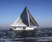 The bay is mostly known for its seafood production, especially blue crabs, clam
s and oysters. The plentiful oyster harvests led to the development of the skipjack, the state boat of Maryland, which is the only remaining working boat type in the United States still under sail power. Other characteristic bay-area workboats include the log canoe
, the pungy
, the bugeye, and the Chesapeake Bay deadrise
.
In the middle of the twentieth century, the bay supported 9,000 full-time watermen, according to one account. Today, the body of water is less productive than it used to be because of runoff
from urban area
s (mostly on the Western Shore
) and farms (especially on the Eastern Shore and in the Susquehanna River watershed), over-harvesting, and invasion of foreign species
.
The bay is famous for its rockfish, a regional name for striped bass
. Once on the verge of extinction, rockfish have made a significant comeback because of legislative action that put a moratorium on rockfishing, which allowed the species to re-populate. Rockfish are now able to be fished in strictly controlled and limited quantities.
Oyster farming
is a growing industry for the bay to help maintain the estuary's productivity as well as a natural effort for filtering impurities from the water in an effort to reduce the effects of man-made pollution
. Oysters are hermaphroditic and will change gender at least once during their lifetime, often starting as male and ending as female; there are numerous ways to cook and eat them, as well as recipes and sauces to accompany oyster dishes. One account:
 In the 1970s, the Chesapeake Bay was discovered to contain one of the planet's first identified marine dead zones, where hypoxic
waters were so depleted of oxygen they were unable to support life, resulting in massive fish kill
s. Today the bay's dead zones are estimated to kill 75,000 tons of bottom-dwelling clams and worms each year, weakening the base of the estuary's food chain
and robbing the blue crab in particular of a primary food source. Crabs are sometimes observed to amass on shore to escape pockets of oxygen-poor water, a behavior known as a "crab jubilee". Hypoxia results in part from large algal bloom
s, which are nourished by the runoff of residential, farm and industrial waste
throughout the watershed. One report in 2010 criticized Amish
farmers for having cows which "generate heaps of manure that easily washes into streams and flows onward into the Chesapeake Bay."
The runoff and pollution have many components that help contribute to the algal blooms which is mainly fed by phosphorus
and nitrogen
. This algae prevents sunlight from reaching the bottom of the bay while alive and deoxygenates the bay's water when it dies and rots. The erosion and runoff of sediment
into the bay, exacerbated by devegetation, construction and the prevalence of pavement in urban and suburban areas, also blocks vital sunlight. The resulting loss of aquatic vegetation
has depleted the habitat for much of the bay's animal life. Beds of eelgrass
, the dominant variety in the southern bay, have shrunk by more than half there since the early 1970s. Overharvesting, pollution, sedimentation and disease has turned much of the bay's bottom into a muddy wasteland.
One particularly harmful source of toxicity
is Pfiesteria piscicida
, which can affect both fish and humans. Pfiesteria caused a small regional panic in the late 1990s when a series of large blooms started killing large numbers of fish while giving swimmers mysterious rashes, and nutrient runoff from chicken farms was blamed for the growth.
The bay improved slightly in terms of the overall health of its ecosystem, earning a rating of 31 out of 100 in 2010, up from 28 in 2008. An estimate in 2006 from a "blue ribbon panel" said cleanup costs would be $15 billion. Compounding the problem is the fact that 100,000 new residents move to the area each year. A report in 2008 in the Washington Post suggested that government administrators had overstated progress on cleanup efforts as a way to "preserve the flow of federal and state money to the project." In 2011 in January, there were reports that millions of fish had died, but officials suggested it was probably the result of extremely cold weather.
The primary problem is overharvesting. Lax government regulations allow anyone with a license to remove oysters from state-owned beds, and although limits are set, they are not strongly enforced. The overharvesting of oysters has made it difficult for them to reproduce, which requires close proximity to one another. A second cause for the oyster depletion is that the drastic increase in human population caused a sharp increase in pollution flowing into the bay.
The bay's oyster industry has also suffered from two diseases: MSX
and Dermo
.
that a wader may lose sight of their feet before their knees are wet.
Efforts of federal, state and local governments, working in partnership through the Chesapeake Bay Program
, and the Chesapeake Bay Foundation
and other nonprofit environmental groups, to restore or at least maintain the current water quality
have had mixed results. One particular obstacle to cleaning up the bay is that much of the polluting substances arise far upstream in tributaries
lying within states far removed from the bay. Despite the state of Maryland spending over $100 million to restore the bay, conditions have continued to grow worse. Twenty years ago, the bay supported over six thousand oystermen. There are now fewer than 500.
Efforts to repopulate the bay via hatcheries have been carried out by a group called the Oyster Recovery Partnership, with some success. They recently placed 6 million oysters on 8 acres (32,374.9 m²) of the Trent Hall sanctuary. Scientists from the Virginia Institute of Marine Science
at the College of William & Mary claim that experimental reefs created in 2004 now house 180 million native oysters, Crassostrea virginica, which is far less than the billions that once existed.
One account suggested how the Chesapeake attracts people:
Tom Wisner has recorded several albums, often about the Chesapeake Bay, and he tried to "capture the voice of the water and the sky, of the rocks and the trees, of the fish and the birds, of the gods of nature he believed still watched over it all." He was known as the Bard of the Chesapeake Bay.
The Capital Newspaper, based in Annapolis, reports about news pertaining to the Western Shore of Maryland and the Annapolis area. Chesapeake Bay Magazine and PropTalk focus on powerboating while SpinSheet focuses on sailing.
Estuary
An estuary is a partly enclosed coastal body of water with one or more rivers or streams flowing into it, and with a free connection to the open sea....
in the United States
United States
The United States of America is a federal constitutional republic comprising fifty states and a federal district...
. It lies off the Atlantic Ocean
Atlantic Ocean
The Atlantic Ocean is the second-largest of the world's oceanic divisions. With a total area of about , it covers approximately 20% of the Earth's surface and about 26% of its water surface area...
, surrounded by Maryland
Maryland
Maryland is a U.S. state located in the Mid Atlantic region of the United States, bordering Virginia, West Virginia, and the District of Columbia to its south and west; Pennsylvania to its north; and Delaware to its east...
and Virginia
Virginia
The Commonwealth of Virginia , is a U.S. state on the Atlantic Coast of the Southern United States. Virginia is nicknamed the "Old Dominion" and sometimes the "Mother of Presidents" after the eight U.S. presidents born there...
. The Chesapeake Bay's drainage basin
Drainage basin
A drainage basin is an extent or an area of land where surface water from rain and melting snow or ice converges to a single point, usually the exit of the basin, where the waters join another waterbody, such as a river, lake, reservoir, estuary, wetland, sea, or ocean...
covers 64299 square miles (166,534 km²) in the District of Columbia and parts of six states: New York
New York
New York is a state in the Northeastern region of the United States. It is the nation's third most populous state. New York is bordered by New Jersey and Pennsylvania to the south, and by Connecticut, Massachusetts and Vermont to the east...
, Pennsylvania
Pennsylvania
The Commonwealth of Pennsylvania is a U.S. state that is located in the Northeastern and Mid-Atlantic regions of the United States. The state borders Delaware and Maryland to the south, West Virginia to the southwest, Ohio to the west, New York and Ontario, Canada, to the north, and New Jersey to...
, Delaware
Delaware
Delaware is a U.S. state located on the Atlantic Coast in the Mid-Atlantic region of the United States. It is bordered to the south and west by Maryland, and to the north by Pennsylvania...
, Maryland
Maryland
Maryland is a U.S. state located in the Mid Atlantic region of the United States, bordering Virginia, West Virginia, and the District of Columbia to its south and west; Pennsylvania to its north; and Delaware to its east...
, Virginia
Virginia
The Commonwealth of Virginia , is a U.S. state on the Atlantic Coast of the Southern United States. Virginia is nicknamed the "Old Dominion" and sometimes the "Mother of Presidents" after the eight U.S. presidents born there...
, and West Virginia
West Virginia
West Virginia is a state in the Appalachian and Southeastern regions of the United States, bordered by Virginia to the southeast, Kentucky to the southwest, Ohio to the northwest, Pennsylvania to the northeast and Maryland to the east...
. More than 150 rivers and streams drain into the bay.
The Chesapeake Bay is approximately 200 miles (300 km) long, from the Susquehanna River
Susquehanna River
The Susquehanna River is a river located in the northeastern United States. At long, it is the longest river on the American east coast that drains into the Atlantic Ocean, and with its watershed it is the 16th largest river in the United States, and the longest river in the continental United...
in the north to the Atlantic Ocean
Atlantic Ocean
The Atlantic Ocean is the second-largest of the world's oceanic divisions. With a total area of about , it covers approximately 20% of the Earth's surface and about 26% of its water surface area...
in the south. At its narrowest point between Kent County's
Kent County, Maryland
Kent County is a county located in the U.S. state of Maryland, on its Eastern Shore. It was named for the county of Kent in England. Its county seat is Chestertown. In 2010, the county population was 20,197...
Plum Point (near Newtown) and the Harford County
Harford County, Maryland
Harford County is a county in the U.S. state of Maryland. In 2010, its population was 244,826. Its county seat is Bel Air. Harford County forms part of the Baltimore-Washington Metropolitan Area.-History:...
shore near Romney Creek, the bay is 2.8 miles (4.5 km) wide; at its widest point, just south of the mouth of the Potomac River
Potomac River
The Potomac River flows into the Chesapeake Bay, located along the mid-Atlantic coast of the United States. The river is approximately long, with a drainage area of about 14,700 square miles...
, it is 30 miles (50 km) wide. Total shoreline for the bay and its tributaries is 11,684 miles (18,804 km), and the surface area of the bay and its major tributaries is 4479 square miles (11,601 km²). Average depth of the bay is 46 feet (14 m) and the maximum depth is 208 feet (63.4 m).
The bay is spanned in two places. The Chesapeake Bay Bridge
Chesapeake Bay Bridge
The Chesapeake Bay Bridge is a major dual-span bridge in the U.S. state of Maryland. Spanning the Chesapeake Bay, it connects the state's rural Eastern Shore region with the more urban Western Shore. The original span opened in 1952 and, at the time, with a length of , it was the world's longest...
crosses the bay in Maryland from Sandy Point
Sandy Point State Park
Sandy Point State Park is a Maryland state park located at Sandy Point, at the western end of the Chesapeake Bay Bridge in Anne Arundel County, Maryland. The park is at the site of a former ferry landing that served the Chesapeake Bay Ferry System...
(near Annapolis) to Kent Island
Kent Island, Maryland
Kent Island is the largest island in the Chesapeake Bay, and a historic place in Maryland. To the east, a narrow channel known as the Kent Narrows barely separates the island from the Delmarva Peninsula, and on the other side, the island is separated from Sandy Point, an area near Annapolis, by...
; and the Chesapeake Bay Bridge-Tunnel
Chesapeake Bay Bridge-Tunnel
The Chesapeake Bay Bridge-Tunnel is a long fixed link crossing the mouth of the Chesapeake Bay and connecting the Delmarva Peninsula's Eastern Shore of Virginia with Virginia Beach and the metropolitan area of Hampton Roads, Virginia...
in Virginia connects Virginia Beach
Virginia Beach, Virginia
Virginia Beach is an independent city located in the Hampton Roads metropolitan area of Virginia, on the Atlantic Ocean at the mouth of the Chesapeake Bay...
to Cape Charles
Cape Charles, Virginia
Cape Charles is a town in Northampton County, Virginia, United States. The population was 1,134 at the 2000 census.-Geography:Cape Charles is located at ....
. The bay has environmental issues but is noted for its beauty; in recent years, a pattern has been that it is becoming "emptier", with fewer crabs, oysters, and watermen.
Etymology
The word Chesepiooc is an AlgonquianAlgonquian languages
The Algonquian languages also Algonkian) are a subfamily of Native American languages which includes most of the languages in the Algic language family. The name of the Algonquian language family is distinguished from the orthographically similar Algonquin dialect of the Ojibwe language, which is a...
word referring to a village "at a big river." It is the seventh oldest surviving English place-name in the U.S., first applied as "Chesepiook" by explorers heading north from the Roanoke Colony
Roanoke Colony
The Roanoke Colony on Roanoke Island in Dare County, present-day North Carolina, United States was a late 16th-century attempt to establish a permanent English settlement in what later became the Virginia Colony. The enterprise was financed and organized by Sir Walter Raleigh and carried out by...
into a Chesapeake tributary in 1585 or 1586. In 2005, Algonquian linguist Blair Rudes "helped to dispel one of the area's most widely held beliefs: that 'Chesapeake' means something like 'Great Shellfish Bay.' It does not, Rudes said. The name might actually mean something like 'Great Water,' or it might have been just a village at the bay's mouth."
Geology
The Chesapeake Bay is the riaRia
A ria is a coastal inlet formed by the partial submergence of an unglaciated river valley. It is a drowned river valley that remains open to the sea. Typically, rias have a dendritic, treelike outline although they can be straight and without significant branches. This pattern is inherited from the...
, or drowned valley, of the Susquehanna, meaning that it was where the river flowed when the sea level was lower. It is not a fjord
Fjord
Geologically, a fjord is a long, narrow inlet with steep sides or cliffs, created in a valley carved by glacial activity.-Formation:A fjord is formed when a glacier cuts a U-shaped valley by abrasion of the surrounding bedrock. Glacial melting is accompanied by rebound of Earth's crust as the ice...
, as the Laurentide Ice Sheet
Laurentide ice sheet
The Laurentide Ice Sheet was a massive sheet of ice that covered hundreds of thousands of square miles, including most of Canada and a large portion of the northern United States, multiple times during Quaternary glacial epochs. It last covered most of northern North America between c. 95,000 and...
never reached as far south as the northernmost point on the bay.
The bay's geology, its present form, and its very location were created by a bolide impact event
Impact event
An impact event is the collision of a large meteorite, asteroid, comet, or other celestial object with the Earth or another planet. Throughout recorded history, hundreds of minor impact events have been reported, with some occurrences causing deaths, injuries, property damage or other significant...
at the end of the Eocene
Eocene
The Eocene Epoch, lasting from about 56 to 34 million years ago , is a major division of the geologic timescale and the second epoch of the Paleogene Period in the Cenozoic Era. The Eocene spans the time from the end of the Palaeocene Epoch to the beginning of the Oligocene Epoch. The start of the...
(about 35.5 million years ago), forming the Chesapeake Bay impact crater
Chesapeake Bay impact crater
The Chesapeake Bay impact crater was formed by a bolide that impacted the eastern shore of North America about 35 million years ago, in the late Eocene epoch. It is one of the best-preserved "wet-target" or marine impact craters, and the largest known impact crater in the U.S...
and the Susquehanna River valley much later. The bay was formed starting about 10,000 years ago when rising sea levels at the end of the last ice age flooded the Susquehanna River valley. Parts of the bay, especially the Calvert County, Maryland
Calvert County, Maryland
Calvert County is a county located in the U.S. state of Maryland. It occupies the Calvert Peninsula which is bordered on the east by the Chesapeake Bay and on the west by the Patuxent River. Calvert County is part of the Southern Maryland region. Calvert County's residents are among the highest...
, coastline, are lined by cliffs composed of deposits from receding waters millions of years ago. These cliffs, generally known as Calvert Cliffs
Calvert Cliffs State Park
Calvert Cliffs State Park is a state park in Calvert County, Maryland, USA, situated on the Chesapeake Bay. On the 1612 John Smith map, the site is called "Rickard's Cliffes"...
, are famous for their fossils, especially fossilized shark
Shark
Sharks are a type of fish with a full cartilaginous skeleton and a highly streamlined body. The earliest known sharks date from more than 420 million years ago....
teeth which are commonly found washed up on the beaches next to the cliffs. Scientists' Cliffs
Scientists' Cliffs
Scientists' Cliffs is an unincorporated community in Calvert County, Maryland, United States. Other names used for the community include Annes Aggravation, Flippos Folly, Pathologists Quagmire, and Scientists Cliff...
is a beach community in Calvert County named for the desire to create a retreat for scientists when the community was founded in 1935.
Much of the bay is quite shallow. At the point where the Susquehanna River flows into the bay, the average depth is 30 feet (9 m), although this soon diminishes to an average of 10 feet (3 m) from the city of Havre de Grace for about 35 miles (56 km), to just north of Annapolis. On average, the depth of the bay is 21 feet (7 m), including tributaries; over 24% of the bay is less than 6 ft (2 m) deep.
The climate of the area surrounding the bay is primarily humid subtropical, with hot, very humid summers and cold to mild winters. Only the area around the mouth of the Susquehanna River is continental in nature, and the mouth of the Susquehanna River and the Susquehanna flats
Mudflat
Mudflats or mud flats, also known as tidal flats, are coastal wetlands that form when mud is deposited by tides or rivers. They are found in sheltered areas such as bays, bayous, lagoons, and estuaries. Mudflats may be viewed geologically as exposed layers of bay mud, resulting from deposition of...
often freeze in winter. It is rare for the surface of the bay to freeze in winter, which happened most recently in the winter of 1976–77.
Salinity
Salinity is the saltiness or dissolved salt content of a body of water. It is a general term used to describe the levels of different salts such as sodium chloride, magnesium and calcium sulfates, and bicarbonates...
zones — oligohaline, mesohaline, and polyhaline
Polyhaline
Polyhaline is a salinity category term applied to brackish estuaries and other water bodies with a salinity of between 18 and 30 ppt . It is the most dense saltwater type we have....
. The fresh water zone runs from the mouth of the Susquehanna River to north Baltimore. The oligohaline zone has very little salt. Salinity varies from 0.5 ppt to 10 ppt, and freshwater species can survive there. The north end of the oligohaline zone is north Baltimore and the south end is the Chesapeake Bay Bridge. The mesohaline zone has a medium amount of salt and runs from the Bay Bridge to the mouth of the Rappahannock River
Rappahannock River
The Rappahannock River is a river in eastern Virginia, in the United States, approximately in length. It traverses the entire northern part of the state, from the Blue Ridge Mountains in the west, across the Piedmont, to the Chesapeake Bay, south of the Potomac River.An important river in American...
. Salinity there ranges from 10.7 ppt to 18 ppt. The polyhaline zone is the saltiest zone, and some of the water can be as salty as sea water. It runs from the mouth of the Rappahannock River to the mouth of the bay. The salinity ranges from 18.7 ppt to 36 ppt. (36 ppt is as salty as the ocean.)
History
In 1524, Italian explorer Giovanni da Verrazzano, in service of the French crown, sailed past the Chesapeake but did not enter the bay. Spanish explorer Lucas Vásquez de AyllónLucas Vásquez de Ayllón
Lucas Vázquez de Ayllón was a Spanish explorer who in 1526 established the short-lived San Miguel de Gualdape colony, the first European attempt at a settlement in what is now the continental United States...
sent an expedition out from Hispaniola
Hispaniola
Hispaniola is a major island in the Caribbean, containing the two sovereign states of the Dominican Republic and Haiti. The island is located between the islands of Cuba to the west and Puerto Rico to the east, within the hurricane belt...
in 1525 which reached the mouths of the Chesapeake and Delaware Bay
Delaware Bay
Delaware Bay is a major estuary outlet of the Delaware River on the Northeast seaboard of the United States whose fresh water mixes for many miles with the waters of the Atlantic Ocean. It is in area. The bay is bordered by the State of New Jersey and the State of Delaware...
s. It may have been the first European expedition to explore parts of the Chesapeake Bay, which the Spaniards called "Bahía de Santa María" or "Bahía de Madre de Dios." De Ayllón established a short-lived Spanish
Spain
Spain , officially the Kingdom of Spain languages]] under the European Charter for Regional or Minority Languages. In each of these, Spain's official name is as follows:;;;;;;), is a country and member state of the European Union located in southwestern Europe on the Iberian Peninsula...
mission settlement, San Miguel de Gualdape
San Miguel de Gualdape
San Miguel de Gualdape was the first European settlement inside what is now United States territory, founded by Spaniard Lucas Vázquez de Ayllón in 1526. It was to last only three months of winter before being abandoned in early 1527....
, in 1526 along the Atlantic coast. Many scholars doubt the assertion that it was as far north as the Chesapeake; most place it in present-day Georgia
Georgia (U.S. state)
Georgia is a state located in the southeastern United States. It was established in 1732, the last of the original Thirteen Colonies. The state is named after King George II of Great Britain. Georgia was the fourth state to ratify the United States Constitution, on January 2, 1788...
's Sapelo Island
Sapelo Island
Sapelo Island is a state-protected island located in McIntosh County, Georgia. The island is reachable only by airplane or boat, with the primary ferry coming from the Sapelo Island Visitors Center in McIntosh County, Georgia, a seven mile , twenty-minute trip.Approximately 97 percent of the...
. In 1573, governor of Spanish Florida, Pedro Menéndez de Márquez
Pedro Menéndez de Márquez
Pedro Menendez Márquez , Marqués de Avilés, was an explorer, Spanish conquistador and governor of Florida. He was a nephew of Pedro Menéndez de Avilés.- Biography :...
conducted further exploration of the Chesapeake.
Captain John Smith of England explored and mapped the bay between 1607 and 1609. Smith wrote in his journal:
There was a mass migration of southern English cavaliers and their Irish and Scottish servants to the Chesapeake Bay region between 1640 and 1675. The "Captain John Smith Chesapeake National Historic Trail
Captain John Smith Chesapeake National Historic Trail
The Captain John Smith Chesapeake National Historic Trail is a series of water routes in the United States extending approximately along the Chesapeake Bay, the nation's largest estuary, and its tributaries in Virginia, Maryland, Delaware, and in the District of Columbia...
", the United States' first all-water National Historic Trail
National Historic Trail
National Historic Trail is a designation for a protected area in the United States containing historic trails and surrounding areas. They are part of the National Trails System....
, was created in July 2006.
The Chesapeake Bay was the site of the Battle of the Chesapeake
Battle of the Chesapeake
The Battle of the Chesapeake, also known as the Battle of the Virginia Capes or simply the Battle of the Capes, was a crucial naval battle in the American War of Independence that took place near the mouth of Chesapeake Bay on 5 September 1781, between a British fleet led by Rear Admiral Sir Thomas...
in 1781, during which the French fleet defeated the Royal Navy
Royal Navy
The Royal Navy is the naval warfare service branch of the British Armed Forces. Founded in the 16th century, it is the oldest service branch and is known as the Senior Service...
in the decisive naval battle of the American Revolutionary War
American Revolutionary War
The American Revolutionary War , the American War of Independence, or simply the Revolutionary War, began as a war between the Kingdom of Great Britain and thirteen British colonies in North America, and ended in a global war between several European great powers.The war was the result of the...
. In the War of 1812
War of 1812
The War of 1812 was a military conflict fought between the forces of the United States of America and those of the British Empire. The Americans declared war in 1812 for several reasons, including trade restrictions because of Britain's ongoing war with France, impressment of American merchant...
, British warships attacked Fort McHenry
Fort McHenry
Fort McHenry, in Baltimore, Maryland, is a star-shaped fort best known for its role in the War of 1812, when it successfully defended Baltimore Harbor from an attack by the British navy in Chesapeake Bay...
at one point; in a separate attack, British troops sailed up the Chesapeake, landed on the west side near Washington D.C., and trekked overland to burn the capital
Burning of Washington
The Burning of Washington was an armed conflict during the War of 1812 between the United Kingdom of Great Britain and Ireland and the United States of America. On August 24, 1814, led by General Robert Ross, a British force occupied Washington, D.C. and set fire to many public buildings following...
. There were so-called Oyster Wars
Oyster Wars
The Oyster Wars were a series of sometimes violent disputes between oyster pirates and authorities and legal watermen from Maryland and Virginia in the waters of the Chesapeake Bay and the Potomac River from 1865 until about 1959.-Background:...
in the late nineteenth and early twentieth centuries.
During the Great Depression
Great Depression
The Great Depression was a severe worldwide economic depression in the decade preceding World War II. The timing of the Great Depression varied across nations, but in most countries it started in about 1929 and lasted until the late 1930s or early 1940s...
in the 1930s, catching and eating oysters continued to be popular.
Today, the Calvert Cliffs Nuclear Power Plant
Calvert Cliffs Nuclear Power Plant
The Calvert Cliffs Nuclear Power Plant is a nuclear power plant located on the western shore of the Chesapeake Bay near Lusby, Calvert County, Maryland.-Overview:...
uses water from the bay to cool its reactor.
The bay is known for the Chesapeake Bay Retriever
Chesapeake Bay Retriever
The Chesapeake Bay Retriever is a breed of dog belonging to the Retriever, Gundog, and Sporting breed groups. Members of the breed may also be referred to as a Chessie, CBR, or Chesapeake. The breed was developed in the United States Chesapeake Bay area during the 19th century...
, a dog breed
Dog breed
Dog breeds are groups of closely related and visibly similar domestic dogs, which are all of the subspecies Canis lupus familiaris, having characteristic traits that are selected and maintained by humans, bred from a known foundation stock....
developed in this area. The Chesapeake Bay Bridge-Tunnel was built, connecting Virginia's eastern shore with its mainland and is approximately 20 miles (32.2 km) long; it has trestle bridges as well as two stretches of two-mile (3 km)-long tunnels which allow unimpeded shipping; the bridge is supported by four 5.25 acres (21,246 m²) man-made islands.
Watershed
The largest rivers flowing directly into the bay, from north to south, are:- Susquehanna RiverSusquehanna RiverThe Susquehanna River is a river located in the northeastern United States. At long, it is the longest river on the American east coast that drains into the Atlantic Ocean, and with its watershed it is the 16th largest river in the United States, and the longest river in the continental United...
- Patapsco RiverPatapsco RiverThe Patapsco River is a river in central Maryland which flows into Chesapeake Bay. The river's tidal portion forms the harbor for the city of Baltimore...
- Chester RiverChester RiverThe Chester River is a major tributary of the Chesapeake Bay on the Delmarva Peninsula. It is about long, and its watershed encompasses , which includes of land. Thus the total watershed area is 20% water. It forms the border between Kent County and Queen Anne's County, Maryland, with its...
- Choptank RiverChoptank RiverThe Choptank River is a major tributary of the Chesapeake Bay on the Delmarva Peninsula. Running for , it rises in Kent County, Delaware, runs through Caroline County, Maryland and forms much of the border between Talbot County, Maryland on the north, and Caroline County and Dorchester County on...
- Patuxent RiverPatuxent RiverThe Patuxent River is a tributary of the Chesapeake Bay in the state of Maryland. There are three main river drainages for central Maryland: the Potomac River to the west passing through Washington D.C., the Patapsco River to the northeast passing through Baltimore, and the Patuxent River between...
- Nanticoke RiverNanticoke RiverThe Nanticoke River is a major tributary of the Chesapeake Bay on the Delmarva Peninsula. It rises in southern Kent County, Delaware, flows through Sussex County, Delaware, and forms the boundary between Dorchester County, Maryland and Wicomico County, Maryland. The river course proceeds southwest...
- Potomac RiverPotomac RiverThe Potomac River flows into the Chesapeake Bay, located along the mid-Atlantic coast of the United States. The river is approximately long, with a drainage area of about 14,700 square miles...
- Pocomoke RiverPocomoke RiverThe Pocomoke River stretches approximately from southern Delaware through southeastern Maryland in the United States. At its mouth, the river is essentially an arm of Chesapeake Bay, whereas the upper river flows through a series of relatively inaccessible wetlands called the Great Cypress Swamp,...
- Rappahannock RiverRappahannock RiverThe Rappahannock River is a river in eastern Virginia, in the United States, approximately in length. It traverses the entire northern part of the state, from the Blue Ridge Mountains in the west, across the Piedmont, to the Chesapeake Bay, south of the Potomac River.An important river in American...
- York RiverYork River (Virginia)The York River is a navigable estuary, approximately long, in eastern Virginia in the United States. It ranges in width from at its head to near its mouth on the west side of Chesapeake Bay. Its watershed drains an area including portions of 17 counties of the coastal plain of Virginia north...
- James RiverJames River (Virginia)The James River is a river in the U.S. state of Virginia. It is long, extending to if one includes the Jackson River, the longer of its two source tributaries. The James River drains a catchment comprising . The watershed includes about 4% open water and an area with a population of 2.5 million...
Flora and fauna
The Chesapeake Bay is home to numerous fauna that either migrate to the bay at some point during the year or live there year round. There are over 300 species of fishFish
Fish are a paraphyletic group of organisms that consist of all gill-bearing aquatic vertebrate animals that lack limbs with digits. Included in this definition are the living hagfish, lampreys, and cartilaginous and bony fish, as well as various extinct related groups...
and numerous shellfish
Shellfish
Shellfish is a culinary and fisheries term for exoskeleton-bearing aquatic invertebrates used as food, including various species of molluscs, crustaceans, and echinoderms. Although most kinds of shellfish are harvested from saltwater environments, some kinds are found only in freshwater...
and crab
Crab
True crabs are decapod crustaceans of the infraorder Brachyura, which typically have a very short projecting "tail" , or where the reduced abdomen is entirely hidden under the thorax...
species. Some of these include the Atlantic menhaden
Atlantic menhaden
The Atlantic menhaden is a silvery, highly compressed fish in the herring family, Clupeidae. A filter feeder, it lives on plankton caught in midwater. Adult fish can filter up to four gallons of water a minute; and they play an important role in clarifying ocean water...
, Striped bass
Striped bass
The striped bass is the state fish of Maryland, Rhode Island, South Carolina, and the state saltwater fish of New York, Virginia, and New Hampshire...
, American eel
American eel
The American eel, Anguilla rostrata, is a catadromous fish found on the eastern coast of North America. It has a snake-like body with a small sharp pointed head. It is brown on top and a tan-yellow color on the bottom. It has sharp pointed teeth but no pelvic fins...
, Eastern oyster
Eastern oyster
The eastern oyster — also called Atlantic oyster or Virginia oyster — is a species of true oyster native to the eastern seaboard and Gulf of Mexico coast of North America. It is also farmed in Puget Sound, Washington, where it is known as the Totten Inlet Virginica. Eastern oysters are and have...
, and the Blue crab.
Bird predators include the American Osprey
Osprey
The Osprey , sometimes known as the sea hawk or fish eagle, is a diurnal, fish-eating bird of prey. It is a large raptor, reaching more than in length and across the wings...
, Great Blue Heron
Great Blue Heron
The Great Blue Heron is a large wading bird in the heron family Ardeidae, common near the shores of open water and in wetlands over most of North and Central America as well as the West Indies and the Galápagos Islands. It is a rare vagrant to Europe, with records from Spain, the Azores and England...
, the Bald Eagle
Bald Eagle
The Bald Eagle is a bird of prey found in North America. It is the national bird and symbol of the United States of America. This sea eagle has two known sub-species and forms a species pair with the White-tailed Eagle...
, Peregrine Falcon
Peregrine Falcon
The Peregrine Falcon , also known as the Peregrine, and historically as the Duck Hawk in North America, is a widespread bird of prey in the family Falconidae. A large, crow-sized falcon, it has a blue-gray back, barred white underparts, and a black head and "moustache"...
, the last two of which were threatened by DDT
DDT
DDT is one of the most well-known synthetic insecticides. It is a chemical with a long, unique, and controversial history....
; their numbers plummeted but have risen in recent years.
The Piping Plover
Piping Plover
The Piping Plover is a small sand-colored, sparrow-sized shorebird that nests and feeds along coastal sand and gravel beaches in North America. The adult has yellow-orange legs, a black band across the forehead from eye to eye, and a black ring around the neck...
is a near threatened
Near Threatened
Near Threatened is a conservation status assigned to species or lower taxa that may be considered threatened with extinction in the near future, although it does not currently qualify for the threatened status...
species which inhabits the wetlands.
Numerous flora also make the Chesapeake Bay their home both on land and underwater. Common submerged aquatic vegetation includes eelgrass
Zostera
Zostera is a small genus of widely distributed seagrass, commonly called marine eelgrass or simply eelgrass . The genus Zostera contains sixteen species.-Ecology:Zostera is found on sandy substrates or in estuaries submerged or partially floating...
and widgeon grass
Ruppia maritima
Ruppia maritima is a species of aquatic plant known by the common name wigeongrass. Despite its Latin name, it is not a marine plant; is perhaps best described as a salt-tolerant freshwater species.-Distribution:...
. A report in 2011 suggested that information on underwater grasses would be released, since "submerged grasses provide food and habitat for a number of species, adding oxygen to the water and improving water clarity." Other vegetation that makes its home in other parts of the bay are wild rice
Wild rice
Wild rice is four species of grasses forming the genus Zizania, and the grain which can be harvested from them. The grain was historically gathered and eaten in both North America and China...
, various trees like the red maple
Red Maple
Acer rubrum , is one of the most common and widespread deciduous trees of eastern North America. It ranges from the Lake of the Woods on the border between Ontario and Minnesota, east to Newfoundland, south to near Miami, Florida, and southwest to east Texas...
and bald cypress, and spartina grass and phragmites
Phragmites
Phragmites, the Common reed, is a large perennial grass found in wetlands throughout temperate and tropical regions of the world. Phragmites australis is sometimes regarded as the sole species of the genus Phragmites, though some botanists divide Phragmites australis into three or four species...
.
Fishing industry
Clam
The word "clam" can be applied to freshwater mussels, and other freshwater bivalves, as well as marine bivalves.In the United States, "clam" can be used in several different ways: one, as a general term covering all bivalve molluscs...
s and oysters. The plentiful oyster harvests led to the development of the skipjack, the state boat of Maryland, which is the only remaining working boat type in the United States still under sail power. Other characteristic bay-area workboats include the log canoe
Log canoe
The log canoe is a type of sailboat developed in the Chesapeake Bay region. Based on the dugout, it was the principal traditional fishing boat of the bay until superseded by the bugeye and the skipjack. However, it is most famous as a racing sailboat, and races continue to be held.The history of...
, the pungy
Pungy
The Pungy is a type of schooner developed in and peculiar to the Chesapeake Bay region. The name is believed to derive from the Pungoteague region of Accomack County, Virginia, where the design was developed in the 1840s and 50s....
, the bugeye, and the Chesapeake Bay deadrise
Chesapeake Bay deadrise
The Chesapeake Bay deadrise is a type of traditional fishing boat used in the Chesapeake Bay. Watermen use these boats year round for everything from crabbing and oystering to catching fish or eels. Traditionally wooden hulled, the deadrise is characterised by a sharp bow that quickly becomes a...
.
In the middle of the twentieth century, the bay supported 9,000 full-time watermen, according to one account. Today, the body of water is less productive than it used to be because of runoff
Surface runoff
Surface runoff is the water flow that occurs when soil is infiltrated to full capacity and excess water from rain, meltwater, or other sources flows over the land. This is a major component of the water cycle. Runoff that occurs on surfaces before reaching a channel is also called a nonpoint source...
from urban area
Urban area
An urban area is characterized by higher population density and vast human features in comparison to areas surrounding it. Urban areas may be cities, towns or conurbations, but the term is not commonly extended to rural settlements such as villages and hamlets.Urban areas are created and further...
s (mostly on the Western Shore
Western Shore
Maryland's Western Shore, not to be confused with Western Maryland, is an area of Maryland west of the Chesapeake Bay. The term does not identify an official region of Maryland but it is often used in contrast to "Eastern Shore"...
) and farms (especially on the Eastern Shore and in the Susquehanna River watershed), over-harvesting, and invasion of foreign species
Invasive species
"Invasive species", or invasive exotics, is a nomenclature term and categorization phrase used for flora and fauna, and for specific restoration-preservation processes in native habitats, with several definitions....
.
The bay is famous for its rockfish, a regional name for striped bass
Striped bass
The striped bass is the state fish of Maryland, Rhode Island, South Carolina, and the state saltwater fish of New York, Virginia, and New Hampshire...
. Once on the verge of extinction, rockfish have made a significant comeback because of legislative action that put a moratorium on rockfishing, which allowed the species to re-populate. Rockfish are now able to be fished in strictly controlled and limited quantities.
Oyster farming
Oyster farming
Oyster farming is an aquaculture practice in which oysters are raised for human consumption. Oyster farming most likely developed in tandem with pearl farming, a similar practice in which oysters are farmed for the purpose of developing pearls...
is a growing industry for the bay to help maintain the estuary's productivity as well as a natural effort for filtering impurities from the water in an effort to reduce the effects of man-made pollution
Water pollution
Water pollution is the contamination of water bodies . Water pollution occurs when pollutants are discharged directly or indirectly into water bodies without adequate treatment to remove harmful compounds....
. Oysters are hermaphroditic and will change gender at least once during their lifetime, often starting as male and ending as female; there are numerous ways to cook and eat them, as well as recipes and sauces to accompany oyster dishes. One account:
Environmental
Hypoxia (environmental)
Hypoxia, or oxygen depletion, is a phenomenon that occurs in aquatic environments as dissolved oxygen becomes reduced in concentration to a point where it becomes detrimental to aquatic organisms living in the system...
waters were so depleted of oxygen they were unable to support life, resulting in massive fish kill
Fish kill
The term fish kill, known also as fish die-off and as fish mortality, is a localized die-off of fish populations which may also be associated with more generalised mortality of aquatic life...
s. Today the bay's dead zones are estimated to kill 75,000 tons of bottom-dwelling clams and worms each year, weakening the base of the estuary's food chain
Food chain
A food web depicts feeding connections in an ecological community. Ecologists can broadly lump all life forms into one of two categories called trophic levels: 1) the autotrophs, and 2) the heterotrophs...
and robbing the blue crab in particular of a primary food source. Crabs are sometimes observed to amass on shore to escape pockets of oxygen-poor water, a behavior known as a "crab jubilee". Hypoxia results in part from large algal bloom
Algal bloom
An algal bloom is a rapid increase or accumulation in the population of algae in an aquatic system. Algal blooms may occur in freshwater as well as marine environments. Typically, only one or a small number of phytoplankton species are involved, and some blooms may be recognized by discoloration...
s, which are nourished by the runoff of residential, farm and industrial waste
Wastewater
Wastewater is any water that has been adversely affected in quality by anthropogenic influence. It comprises liquid waste discharged by domestic residences, commercial properties, industry, and/or agriculture and can encompass a wide range of potential contaminants and concentrations...
throughout the watershed. One report in 2010 criticized Amish
Amish
The Amish , sometimes referred to as Amish Mennonites, are a group of Christian church fellowships that form a subgroup of the Mennonite churches...
farmers for having cows which "generate heaps of manure that easily washes into streams and flows onward into the Chesapeake Bay."
The runoff and pollution have many components that help contribute to the algal blooms which is mainly fed by phosphorus
Phosphorus
Phosphorus is the chemical element that has the symbol P and atomic number 15. A multivalent nonmetal of the nitrogen group, phosphorus as a mineral is almost always present in its maximally oxidized state, as inorganic phosphate rocks...
and nitrogen
Nitrogen
Nitrogen is a chemical element that has the symbol N, atomic number of 7 and atomic mass 14.00674 u. Elemental nitrogen is a colorless, odorless, tasteless, and mostly inert diatomic gas at standard conditions, constituting 78.08% by volume of Earth's atmosphere...
. This algae prevents sunlight from reaching the bottom of the bay while alive and deoxygenates the bay's water when it dies and rots. The erosion and runoff of sediment
Sediment
Sediment is naturally occurring material that is broken down by processes of weathering and erosion, and is subsequently transported by the action of fluids such as wind, water, or ice, and/or by the force of gravity acting on the particle itself....
into the bay, exacerbated by devegetation, construction and the prevalence of pavement in urban and suburban areas, also blocks vital sunlight. The resulting loss of aquatic vegetation
Aquatic plant
Aquatic plants are plants that have adapted to living in aquatic environments. They are also referred to as hydrophytes or aquatic macrophytes. These plants require special adaptations for living submerged in water, or at the water's surface. Aquatic plants can only grow in water or in soil that is...
has depleted the habitat for much of the bay's animal life. Beds of eelgrass
Zostera
Zostera is a small genus of widely distributed seagrass, commonly called marine eelgrass or simply eelgrass . The genus Zostera contains sixteen species.-Ecology:Zostera is found on sandy substrates or in estuaries submerged or partially floating...
, the dominant variety in the southern bay, have shrunk by more than half there since the early 1970s. Overharvesting, pollution, sedimentation and disease has turned much of the bay's bottom into a muddy wasteland.
One particularly harmful source of toxicity
Toxicity
Toxicity is the degree to which a substance can damage a living or non-living organisms. Toxicity can refer to the effect on a whole organism, such as an animal, bacterium, or plant, as well as the effect on a substructure of the organism, such as a cell or an organ , such as the liver...
is Pfiesteria piscicida
Pfiesteria piscicida
Pfiesteria piscicida is a dinoflagellate species of the genus Pfiesteria that some researchers claim is responsible for many harmful algal blooms in the 1980s and 1990s on the coast of North Carolina and Maryland...
, which can affect both fish and humans. Pfiesteria caused a small regional panic in the late 1990s when a series of large blooms started killing large numbers of fish while giving swimmers mysterious rashes, and nutrient runoff from chicken farms was blamed for the growth.
The bay improved slightly in terms of the overall health of its ecosystem, earning a rating of 31 out of 100 in 2010, up from 28 in 2008. An estimate in 2006 from a "blue ribbon panel" said cleanup costs would be $15 billion. Compounding the problem is the fact that 100,000 new residents move to the area each year. A report in 2008 in the Washington Post suggested that government administrators had overstated progress on cleanup efforts as a way to "preserve the flow of federal and state money to the project." In 2011 in January, there were reports that millions of fish had died, but officials suggested it was probably the result of extremely cold weather.
Depletion of oysters
While the bay's salinity is ideal for oysters and the oyster fishery was at one time the bay's most commercially viable, the population has in the last fifty years been devastated. Maryland once had roughly 200000 acres (809.4 km²) of oyster reefs. Today it has about 36,000. It has been estimated that in pre-colonial times, oysters could filter the entirety of the bay in about 3.3 days; by 1988 this time had increased to 325 days. The harvest's gross value decreased 88% from 1982 to 2007. One report suggested the bay had fewer oysters in 2008 than 25 years earlier.The primary problem is overharvesting. Lax government regulations allow anyone with a license to remove oysters from state-owned beds, and although limits are set, they are not strongly enforced. The overharvesting of oysters has made it difficult for them to reproduce, which requires close proximity to one another. A second cause for the oyster depletion is that the drastic increase in human population caused a sharp increase in pollution flowing into the bay.
The bay's oyster industry has also suffered from two diseases: MSX
Haplosporidium nelsoni
Haplosporidium nelsoni is a pathogen of oysters, that originally caused oyster populations to experience high mortality rates in the 1950s, and still is quite prevalent today. The disease caused by H. nelsoni is also known as MSX...
and Dermo
Perkinsus marinus
Perkinsus marinus is a prevalent pathogen of oysters, causing massive mortality in oyster populations. The disease it causes is known as "Dermo" ,and is characterized by proteolytic degradation of oyster tissues...
.
Oyster recovery attempts
The depletion of oysters has had a particularly harmful effect on the quality of the bay. Oysters serve as natural water filters, and their decline has further reduced the water quality of the bay. Water that was once clear for meters is now so turbidTurbidity
Turbidity is the cloudiness or haziness of a fluid caused by individual particles that are generally invisible to the naked eye, similar to smoke in air. The measurement of turbidity is a key test of water quality....
that a wader may lose sight of their feet before their knees are wet.
Efforts of federal, state and local governments, working in partnership through the Chesapeake Bay Program
Chesapeake Bay Program
The Chesapeake Bay Program is the regional partnership that directs and conducts the restoration of the Chesapeake Bay in the United States. As a partnership, the Chesapeake Bay Program brings together members of various state, federal, academic and local watershed organizations to build and adopt...
, and the Chesapeake Bay Foundation
Chesapeake Bay Foundation
The Chesapeake Bay Foundation is a non-profit organization devoted to the restoration and protection of the Chesapeake Bay in the United States. It was founded in 1967 and has headquarters offices in Annapolis, Maryland...
and other nonprofit environmental groups, to restore or at least maintain the current water quality
Water quality
Water quality is the physical, chemical and biological characteristics of water. It is a measure of the condition of water relative to the requirements of one or more biotic species and or to any human need or purpose. It is most frequently used by reference to a set of standards against which...
have had mixed results. One particular obstacle to cleaning up the bay is that much of the polluting substances arise far upstream in tributaries
Tributary
A tributary or affluent is a stream or river that flows into a main stem river or a lake. A tributary does not flow directly into a sea or ocean...
lying within states far removed from the bay. Despite the state of Maryland spending over $100 million to restore the bay, conditions have continued to grow worse. Twenty years ago, the bay supported over six thousand oystermen. There are now fewer than 500.
Efforts to repopulate the bay via hatcheries have been carried out by a group called the Oyster Recovery Partnership, with some success. They recently placed 6 million oysters on 8 acres (32,374.9 m²) of the Trent Hall sanctuary. Scientists from the Virginia Institute of Marine Science
Virginia Institute of Marine Science
The Virginia Institute of Marine Science is one of the oldest and largest schools of oceanographyfocused on coastal ocean and estuarine science in the United States....
at the College of William & Mary claim that experimental reefs created in 2004 now house 180 million native oysters, Crassostrea virginica, which is far less than the billions that once existed.
Tourism
The Chesapeake Bay is a main feature for tourists who visit Maryland and Virginia each year. Fishing, crabbing, swimming, boating, kayaking, and sailing are extremely popular activities enjoyed on the waters of the Chesapeake Bay. As a result, tourism has a notable impact on Maryland's economy One report suggested that Annapolis was an appealing spot for families, water sports and boating. Commentator Terry Smith spoke about the bay's beauty:One account suggested how the Chesapeake attracts people:
Tom Wisner has recorded several albums, often about the Chesapeake Bay, and he tried to "capture the voice of the water and the sky, of the rocks and the trees, of the fish and the birds, of the gods of nature he believed still watched over it all." He was known as the Bard of the Chesapeake Bay.
Publications
There are several magazines and publications that cover topics directly related to the Chesapeake Bay and life and tourism within the bay region.The Capital Newspaper, based in Annapolis, reports about news pertaining to the Western Shore of Maryland and the Annapolis area. Chesapeake Bay Magazine and PropTalk focus on powerboating while SpinSheet focuses on sailing.
Fiction
- ChesapeakeChesapeake (novel)Chesapeake is a novel by James A. Michener, published by Random House in 1978. The story deals with several families living in the Chesapeake Bay area, from 1583 to 1978.-Plot summary:...
, a 1978 novel by author James A. MichenerJames A. MichenerJames Albert Michener was an American author of more than 40 titles, the majority of which were sweeping sagas, covering the lives of many generations in particular geographic locales and incorporating historical facts into the stories... - John BarthJohn BarthJohn Simmons Barth is an American novelist and short-story writer, known for the postmodernist and metafictive quality of his work.-Life:...
's 1982 Sabbatical: A RomanceSabbatical: A RomanceSabbatical: A Romance is a novel by the American writer John Barth, published in 1982. The story is centered on a yacht race through the Chesapeake Bay, and also include the case of the death of ex-CIA officer John Arthur Paisley.-See also:...
, a novel centered on a yacht race through the Chesapeake Bay - John BarthJohn BarthJohn Simmons Barth is an American novelist and short-story writer, known for the postmodernist and metafictive quality of his work.-Life:...
's 1987 The Tidewater Tales, a novel in which a married couple tell stories to each other as they cruise the bay. - Jacob Have I LovedJacob Have I LovedJacob Have I Loved is a novel by Katherine Paterson that won the 1981 Newbery Medal. The title refers to the sibling rivalry between Jacob and Esau in the Jewish and Christian Bible, and comes directly from Romans 9:13: As it is written, "Jacob have I loved, but Esau have I hated."The novel...
by Katherine PatersonKatherine PatersonKatherine Paterson is an American author of children's novels. She wrote Bridge to Terabithia and has received several of the major international awards for children's literature.- Early life:...
, winner of the 1981 Newbery MedalNewbery MedalThe John Newbery Medal is a literary award given by the Association for Library Service to Children, a division of the American Library Association . The award is given to the author of the most distinguished contribution to American literature for children. The award has been given since 1922. ...
. This is a novel about the relationship between two sisters in a waterman family who grow up on an island in the Bay.
See also
- ChesepianChesepianThe Chesepian or Chesapeake were a NativeAmerican tribe who inhabited the area now known as South Hampton Roads in the U.S. state of Virginia prior to their annihilation by the Powhatan Confederacy early in the 17th century. They occupied an area which is now the Norfolk, Portsmouth, Chesapeake,...
- Delmarva PeninsulaDelmarva PeninsulaThe Delmarva Peninsula is a large peninsula on the East Coast of the United States, occupied by most of Delaware and portions of Maryland and Virginia...
- Dead zone (ecology)Dead zone (ecology)Dead zones are hypoxic areas in the world's oceans, the observed incidences of which have been increasing since oceanographers began noting them in the 1970s. These occur near inhabited coastlines, where aquatic life is most concentrated...
- Chessie (sea monster)Chessie (sea monster)Chessie is a legendary sea monster said to live in the midst of the Chesapeake Bay. Over the years there have been many alleged sightings of a serpent-like creature with flippers as part of its body....
- National Estuarine Research Reserve SystemNational Estuarine Research ReserveThe National Estuarine Research Reserve System is a program of the United States government. The program establishes federal-state partnerships under the Coastal Zone Management Act to create a system of estuarine research reserves representative of the various regions and estuarine types in the...
- List of islands in Maryland (with the islands in the bay)
- Coastal and Estuarine Research FederationCoastal and Estuarine Research FederationThe Coastal and Estuarine Research Federation is a private, nonprofit organization that was created in 1971. At that time, the members of two regionally-based organizations, the Atlantic Estuarine Research Society and the New England Estuarine Research Society recognized the need for a third...
- Chesapeake Climate Action NetworkChesapeake Climate Action NetworkThe Chesapeake Climate Action Network was officially launched on July 1, 2002 with a seed grant from the Rockefeller Brothers Fund. Chesapeake Climate Action Network is a registered 5013 organization located in Takoma Park, Maryland....
- Chesapeake Bay Interpretive Buoy SystemChesapeake Bay Interpretive Buoy SystemChesapeake Bay Interpretive Buoy System is a network of observational buoys that are deployed throughout the Chesapeake Bay to observe the estuary's changing conditions and to serve as way points along the Captain John Smith Chesapeake National Historic Trail. They are maintained by the United...
- Chesapeake and Delaware CanalChesapeake and Delaware CanalThe Chesapeake and Delaware Canal is a 14-mile long, 450-foot wide and 40-foot deep ship canal that cuts across the states of Maryland and Delaware, in the United States. It connects the waters of the Delaware River with those of the Chesapeake Bay and the Port of Baltimore...
Further reading
- Cleaves, E.T. et al. (2006). Quaternary geologic map of the Chesapeake Bay 4º x 6º quadrangle, United States [Miscellaneous Investigations Series; Map I-1420 (NJ-18)]. Reston, VA: U.S. Department of the Interior, U.S. Geological Survey.
- Phillips, S.W., ed. (2007). Synthesis of U.S. Geological Survey science for the Chesapeake Bay ecosystem and implications for environmental management [U.S. Geological Survey Circular 1316]. Reston, VA: U.S. Department of the Interior, U.S. Geological Survey.
- Thomas, William G., III. "The Chesapeake Bay." Southern Spaces, April 16, 2004, http://southernspaces.org/2004/chesapeake-bay.
- William W. Warner, Beautiful Swimmers, about the history, ecology and anthropology of the Chesapeake Bay, published 1976
External links
- Eyes on the Bay Maryland Department of Natural Resources' Chesapeake and Coastal Bays Water Quality Data and Information
- Bay Backpack – Chesapeake Bay education resources for educators
- Chesapeake Bay Foundation
- Chesapeake Research Consortium
- Alliance for the Chesapeake Bay
- Chesapeake Bay Program
- Chesapeake Bay Journal
- Chesapeake Bay Gateways Network
- Chesapeake Community Modeling Program
- Chesapeake Bay Bridge (near Annapolis, MD)
- Chesapeake Bay Bridge-Tunnel
- Maryland Sea Grant
- National Geographic- Saving The Chesapeake
- National Geographic- Exploring The Chesapeake Then and Now
- National Geographic Magazine Jamestown/Werowocomoco Interactive
- Captain John Smith Chesapeake National Historic Water Trail.
- University of Maryland Center for Environmental Science Research and science application activities emphasizing Chesapeake Bay and its watershed.
- Chesapeake Bay Health Report Card
- Always-Updated Event Calendar for the Chesapeake Bay.