
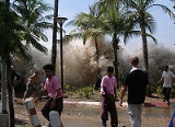
is a series of water waves caused by the displacement of a large volume of a body of water, typically an ocean or a large lake
. Earthquake
s, volcanic eruptions and other underwater explosion
s (including detonations of underwater nuclear devices), landslides, glacier calvings
, meteorite impacts
and other disturbances above or below water all have the potential to generate a tsunami.
Tsunami waves do not resemble normal sea waves, because their wavelength is far longer.
365 A tsunami devastates the city of Alexandria, Egypt. The tsunami is caused by an earthquake estimated to be 8.0 on the Richter Scale. 5,000 people perished in Alexandria, and 45,000 more died outside the city.
1343 A tsunami, caused by the earthquake in the Tyrrhenian Sea, devastates Naples (Italy) and the Maritime Republic of Amalfi, among other places.
1755 Lisbon earthquake: In Portugal, Lisbon is destroyed by a massive earthquake and tsunami, killing between sixty thousand and ninety thousand people.
1833 A massive undersea earthquake, estimated magnitude between 8.7-9.2 rocks Sumatra, producing a massive tsunami all along the Indonesian coast.
1906 A typhoon with tsunami kills an estimated 10,000 people in Hong Kong.
1929 1929 Grand Banks earthquake: Off the south coast of Newfoundland in the Atlantic Ocean, a Richter magnitude 7.2 submarine earthquake, centered on Grand Banks, breaks 12 submarine transatlantic telegraph cables and triggers a tsunami that destroys many south coast communities in the Burin Peninsula.
1946 Aleutian Island earthquake: A 7.8 magnitude earthquake near the Aleutian Islands creates a tsunami that strikes the Hawaiian Islands killing 159, mostly in Hilo.
1957 A magnitude 8.3 earthquake in the Andreanof Islands, Alaska triggers a Pacific-wide tsunami causing extensive damage to Hawaii and Oahu.
1983 A strong 7.7 magnitude earthquake strikes Japan, triggering a tsunami that kills at least 104 people and injures thousands. Many people go missing and thousands of buildings are destroyed.
1997 The Soufriere Hills volcano on the island of Montserrat explodes, creating a small tsunami offshore.