

List of whitewater rivers
Encyclopedia
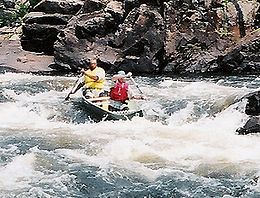
Rapid
A rapid is a section of a river where the river bed has a relatively steep gradient causing an increase in water velocity and turbulence. A rapid is a hydrological feature between a run and a cascade. A rapid is characterised by the river becoming shallower and having some rocks exposed above the...
s or whitewater
Whitewater
Whitewater is formed in a rapid, when a river's gradient increases enough to disturb its laminar flow and create turbulence, i.e. form a bubbly, or aerated and unstable current; the frothy water appears white...
turbulence. This list only focusses on rivers which are suitable for whitewater sports such as canoeing
Whitewater canoeing
Whitewater canoeing is the sport of paddling a canoe on a moving body of water, typically a whitewater river. Whitewater canoeing can range from simple, carefree gently moving water, to demanding, dangerous whitewater. River rapids are graded like ski runs according to the difficulty, danger or...
, kayaking
Whitewater kayaking
Whitewater kayaking is the sport of paddling a kayak on a moving body of water, typically a whitewater river. Whitewater kayaking can range from simple, carefree gently moving water, to demanding, dangerous whitewater. River rapids are graded like ski runs according to the difficulty, danger or...
, and rafting
Rafting
Rafting or white water rafting is a challenging recreational outdoor activity using an inflatable raft to navigate a river or other bodies of water. This is usually done on white water or different degrees of rough water, in order to thrill and excite the raft passengers. The development of this...
.
Africa
- ZambeziZambeziThe Zambezi is the fourth-longest river in Africa, and the largest flowing into the Indian Ocean from Africa. The area of its basin is , slightly less than half that of the Nile...
, ZambiaZambiaZambia , officially the Republic of Zambia, is a landlocked country in Southern Africa. The neighbouring countries are the Democratic Republic of the Congo to the north, Tanzania to the north-east, Malawi to the east, Mozambique, Zimbabwe, Botswana and Namibia to the south, and Angola to the west.... - NileNileThe Nile is a major north-flowing river in North Africa, generally regarded as the longest river in the world. It is long. It runs through the ten countries of Sudan, South Sudan, Burundi, Rwanda, Democratic Republic of the Congo, Tanzania, Kenya, Ethiopia, Uganda and Egypt.The Nile has two major...
, UgandaUgandaUganda , officially the Republic of Uganda, is a landlocked country in East Africa. Uganda is also known as the "Pearl of Africa". It is bordered on the east by Kenya, on the north by South Sudan, on the west by the Democratic Republic of the Congo, on the southwest by Rwanda, and on the south by... - Tana RiverTana River (Kenya)The long Tana River is the longest river in Kenya, and gives its name to the Tana River District. Its tributaries include the Thika. The river rises in the Aberdare Mountains to the west of Nyeri. Initially it runs east before turning south around the massif of Mount Kenya. The river then runs...
, KenyaKenyaKenya , officially known as the Republic of Kenya, is a country in East Africa that lies on the equator, with the Indian Ocean to its south-east...
Thailand
- Wang Thong RiverWang Thong RiverThe Wang Thong River is a river in Thailand. Its source lies in the Phetchabun Mountains in the Khao Kho District, Thailand.It flows through Thung Salaeng Luang National Park and forms Namtok Sri Dit and Namtok Kaeng Sopha in the Wang Thong District of Phitsanulok Province, and finally flows...
is a popular whitewater rafting destination in the Phitsanulok ProvincePhitsanulok ProvincePhitsanulok is a provinces of Thailand, located in the north. Neighboring provinces are Loei, Phetchabun, Phichit, Kamphaeng Phet, Sukhothai, Uttaradit. In the north-east it also has a short border with Xaignabouli of Laos....
of ThailandThailandThailand , officially the Kingdom of Thailand , formerly known as Siam , is a country located at the centre of the Indochina peninsula and Southeast Asia. It is bordered to the north by Burma and Laos, to the east by Laos and Cambodia, to the south by the Gulf of Thailand and Malaysia, and to the...
. It has rapids ranging from difficulty levels of 3 through 5.
India
In the north, most rivers in India descend from the HimalayasHimalayas
The Himalaya Range or Himalaya Mountains Sanskrit: Devanagari: हिमालय, literally "abode of snow"), usually called the Himalayas or Himalaya for short, is a mountain range in Asia, separating the Indian subcontinent from the Tibetan Plateau...
, bringing with them ample rapids to encounter. Towards the south, most rivers tumble down from the Western Ghats
Western Ghats
The Western Ghats, Western Ghauts or the Sahyādri is a mountain range along the western side of India. It runs north to south along the western edge of the Deccan Plateau, and separates the plateau from a narrow coastal plain along the Arabian Sea. The Western Ghats block rainfall to the Deccan...
and flow east, with some exceptions.
North India
- ZanskarZanskarZanskar is a subdistrict or tehsil of the Kargil district, which lies in the eastern half of the Indian state of Jammu and Kashmir. The administrative centre is Padum...
, a Grand Canyonesque experience. Class III-IV. Gradings, as on all rivers, subject to change depending on volume of water. - Alaknanda
- BhagirathiBhagirathi RiverThe Bhāgīrathī is a turbulent Himalayan river in the state of Uttarakhand, India, that is the source stream of the Ganges—the major river of the Gangetic plain of Northern India and the holy river of Hinduism.-Etymology:...
- MandakiniMandakini RiverMandakini is a tributary of the Alaknanda River. Mandakini originates from the Charabari Glacier near Kedarnath in Uttarakhand, India. Mandakini is fed by Vasukiganga River at Sonprayag. Mandakini joins Alaknanda at Rudraprayag...
- Ganges
- TonsTons RiverThe Tons is the largest tributary of the Yamuna and flows through Garhwal region in Uttarakhand, touching Himachal Pradesh. The Tons thrust is named after this river....
- KaliKali' , also known as ' , is the Hindu goddess associated with power, shakti. The name Kali comes from kāla, which means black, time, death, lord of death, Shiva. Kali means "the black one". Since Shiva is called Kāla - the eternal time, Kālī, his consort, also means "Time" or "Death" . Hence, Kāli is...
- YamunaYamunaThe Yamuna is the largest tributary river of the Ganges in northern India...
- TeestaTeesta RiverRiver Teesta or Tista is said to be the lifeline of the Indian state of Sikkim, flowing for almost the entire length of the state and carving out verdant Himalayan temperate and tropical river valleys. The emerald-coloured river then forms the border between Sikkim and West Bengal before joining...
- Rangit
South India
- Kali River (Karnataka)Kali River (Karnataka)The Kali River or Kalinadi is a river flowing through Karwar, Uttara Kannada district Karnataka state in India. The river takes its birth in Diggi, a small village in Uttar Kannada district...
, section near Dandeli. Class III-III+ - Cauvery, near Bheemeshwari. Class II-II+
- Upper Barapole, in Coorg. Class III-IV. Very creekish river.
- Sharda, Class III
- Sitanadi
Malaysia
- Padas, located in Sabah, Borneo. Class III-IV (during rainy season - class V).
- Klias, located in Sabah, Borneo. Class I-II
Philippines
- Cagayan (de Oro) River, located in Cagayan de Oro City, Misamis Oriental, Philippines. Class II-III (upper section - class IV)
- Bubunawan River, located in Cagayan de Oro City, Misamis Oriental, Philippines. Class II-III
- Tumalaong River, located in Cagayan de Oro City, Misamis Oriental, Philippines. Class II-III
- Tagoloan River, located in Tagoloan, Misamis Oriental, Philippines. Class I-II (upper Tagoloan - Class II-IV)
- Malitbog River, located in Malitbog, Bukidnon, Philippines. Class II-III (creeking)
- Agusan River, located in Agusan, Cagayan de Oro city, Philippines. Class II-III (creeking)
- F.S. Catanico River, located in F.S Catanico, Cagayan de Oro City, Philippines. Class II-III (creeking, water is seldom high)
United Kingdom
Whitewater rivers in the UKUnited Kingdom
The United Kingdom of Great Britain and Northern IrelandIn the United Kingdom and Dependencies, other languages have been officially recognised as legitimate autochthonous languages under the European Charter for Regional or Minority Languages...
are typically low volume and technical. In England
England
England is a country that is part of the United Kingdom. It shares land borders with Scotland to the north and Wales to the west; the Irish Sea is to the north west, the Celtic Sea to the south west, with the North Sea to the east and the English Channel to the south separating it from continental...
and Wales
Wales
Wales is a country that is part of the United Kingdom and the island of Great Britain, bordered by England to its east and the Atlantic Ocean and Irish Sea to its west. It has a population of three million, and a total area of 20,779 km²...
rivers are typically less than 20 m³/s, and some are run with less than 1 m³/s (usually these involve skidding the kayak down steep rockslides and small waterfalls). In Scotland
Scotland
Scotland is a country that is part of the United Kingdom. Occupying the northern third of the island of Great Britain, it shares a border with England to the south and is bounded by the North Sea to the east, the Atlantic Ocean to the north and west, and the North Channel and Irish Sea to the...
there are also a few bigger volume (up to about 50 m³/s) rivers.
Almost all runs in England and Wales need recent rain to be at a paddleable level, and many can only be run immediately after heavy rain. In Scotland some bigger rivers can be run for weeks after rain although as with the rest of the country, most need recent wet weather. The paddling season is year-round but the rivers are more often runnable in winter (the wettest months of the year being December and January). Exceptions to this include rivers which have artificially maintained flows from reservoirs. On these rivers flow may increase in dry weather as more water is released. The Afon Tryweryn
Afon Tryweryn
For the flooding of the Tryweryn Valley, see Llyn Celyn.The Tryweryn is a river in north Wales which starts at Llyn Tryweryn in the Snowdonia National Park and after joins the river Dee at Bala. It is one of the main tributaries of the Dee and has been dammed to form Llyn Celyn...
is one example in Wales.
Most runs offer only a few kilometres of whitewater; often several rivers can be run on a wet day. Some rivers consist of only a single rapid. Only a few rivers (such as the Findhorn
River Findhorn
The River Findhorn is one of the longest rivers in Scotland. Located in the north east, it flows into the Moray Firth on the north coast. It has one of the largest non-firth estuaries in Scotland....
and Spean in the Scottish Highlands) have more than a days' worth of paddling, and most of this tends to be grade III or less.
The River Dart
River Dart
The River Dart is a river in Devon, England which rises high on Dartmoor, and releases to the sea at Dartmouth. Its valley and surrounding area is a place of great natural beauty.-Watercourse:...
excepted, there is no natural whitewater in the (mainly flat) south and east of England. Here whitewater paddlers often go playboating
Playboating
Playboating is a discipline of whitewater kayaking or canoeing where the paddler performs various technical moves in one place , as opposed to downriver whitewater canoeing or kayaking where the objective is to travel the length of a section of river...
at man made weir
Weir
A weir is a small overflow dam used to alter the flow characteristics of a river or stream. In most cases weirs take the form of a barrier across the river that causes water to pool behind the structure , but allows water to flow over the top...
s. Hurley weir on the River Thames
River Thames
The River Thames flows through southern England. It is the longest river entirely in England and the second longest in the United Kingdom. While it is best known because its lower reaches flow through central London, the river flows alongside several other towns and cities, including Oxford,...
west of London is probably the most popular. There are several artificial whitewater
Artificial whitewater
An artificial whitewater course is a site for whitewater canoeing, whitewater kayaking, whitewater racing, whitewater rafting, playboating and slalom canoeing with artificially generated rapids.-Flow diversion:...
courses, where water is pumped or diverted though a concrete channel containing obstacles to create rapids. There is a 28 m³/s artificial whitewater course on the Trent
River Trent
The River Trent is one of the major rivers of England. Its source is in Staffordshire on the southern edge of Biddulph Moor. It flows through the Midlands until it joins the River Ouse at Trent Falls to form the Humber Estuary, which empties into the North Sea below Hull and Immingham.The Trent...
at Holme Pierrepont
Holme Pierrepont
Holme Pierrepont is a hamlet located south of the city of Nottingham in Nottinghamshire, England. It is in the Gamston ward of the Rushcliffe local authority in the East Midlands region....
in Nottingham
Nottingham
Nottingham is a city and unitary authority in the East Midlands of England. It is located in the ceremonial county of Nottinghamshire and represents one of eight members of the English Core Cities Group...
(at the National Watersports Centre
Holme Pierrepont National Watersports Centre
The National Watersports Centre, Holme Pierrepont is located in the hamlet of Holme Pierrepont near Nottingham, England and on the River Trent....
), a 5 m³/s course on the Tees
River Tees
The River Tees is in Northern England. It rises on the eastern slope of Cross Fell in the North Pennines, and flows eastwards for 85 miles to reach the North Sea between Hartlepool and Redcar.-Geography:...
in Teesside
Teesside
Teesside is the name given to the conurbation in the north east of England made up of the towns of Middlesbrough, Stockton-on-Tees, Redcar, Billingham and surrounding settlements near the River Tees. It was also the name of a local government district between 1968 and 1974—the County Borough of...
, and smaller courses on the Nene at Northampton
Northampton
Northampton is a large market town and local government district in the East Midlands region of England. Situated about north-west of London and around south-east of Birmingham, Northampton lies on the River Nene and is the county town of Northamptonshire. The demonym of Northampton is...
, and at Cardington
Cardington Artificial Slalom Course
Cardington Artificial Slalom Course was the first artificial whitewater canoe slalom course in the UK when it was completed in July 1982, having been first discussed in 1972....
.
In England
England
England is a country that is part of the United Kingdom. It shares land borders with Scotland to the north and Wales to the west; the Irish Sea is to the north west, the Celtic Sea to the south west, with the North Sea to the east and the English Channel to the south separating it from continental...
Commercial rafting is limited to artificial whitewater courses (where it often provides the majority of the courses' income). Bigger and more reliable rivers can be found in Scotland
Scotland
Scotland is a country that is part of the United Kingdom. Occupying the northern third of the island of Great Britain, it shares a border with England to the south and is bounded by the North Sea to the east, the Atlantic Ocean to the north and west, and the North Channel and Irish Sea to the...
and Wales
Wales
Wales is a country that is part of the United Kingdom and the island of Great Britain, bordered by England to its east and the Atlantic Ocean and Irish Sea to its west. It has a population of three million, and a total area of 20,779 km²...
, in particular the River Findhorn
River Findhorn
The River Findhorn is one of the longest rivers in Scotland. Located in the north east, it flows into the Moray Firth on the north coast. It has one of the largest non-firth estuaries in Scotland....
, River Orchy
River Orchy
The River Orchy is located in Dalmally, Argyll, Scotland. It rises in the Black Mount Forest, passes through Loch Tulla and Glen Orchy before reaching Loch Awe. There are falls and islands within the river...
, River Spey
River Spey
The River Spey is a river in the northeast of Scotland, the second longest and the fastest-flowing river in Scotland...
, River Tay
River Tay
The River Tay is the longest river in Scotland and the seventh-longest in the United Kingdom. The Tay originates in western Scotland on the slopes of Ben Lui , then flows easterly across the Highlands, through Loch Dochhart, Loch Lubhair and Loch Tay, then continues east through Strathtay , in...
and the Afon Tryweryn
Afon Tryweryn
For the flooding of the Tryweryn Valley, see Llyn Celyn.The Tryweryn is a river in north Wales which starts at Llyn Tryweryn in the Snowdonia National Park and after joins the river Dee at Bala. It is one of the main tributaries of the Dee and has been dammed to form Llyn Celyn...
.
There are several sites off the west coast of Britain where strong tidal currents channeled between islands create big volume sections of whitewater. These include the Bitches in Pembrokeshire in Wales, and the Falls of Lora
Falls of Lora
The Falls of Lora is a tidal race which forms at the mouth of Loch Etive when a particularly high tide runs out from the loch. They form white water rapids for two to five days either side of the spring tides....
on the west coast of Scotland.
Legal access to whitewater is a big issue in England and Wales. The public are only allowed access to a tiny proportion of the available whitewater, and often this is restricted to a few months or even a few days per year. This limits commercial operations and the activities of clubs, but many individual kayakers still paddle illegally. Rivers are almost all private and access must be agreed with all of the riparian owners (the owners of the land either side of the river) and the owners of the fishing rights, otherwise canoeing or kayaking there is trespass
Trespass
Trespass is an area of tort law broadly divided into three groups: trespass to the person, trespass to chattels and trespass to land.Trespass to the person, historically involved six separate trespasses: threats, assault, battery, wounding, mayhem, and maiming...
(although landowners can do little other than tell trespassers to leave their property). Agreements rarely exist as there is no incentive for the owners of rivers to let anyone else use them. In Scotland, like most of the rest of the world, access to whitewater is legal and has never been illegal. It has been enshrined in law in the recent Scottish Land Reform
Land reform
[Image:Jakarta farmers protest23.jpg|300px|thumb|right|Farmers protesting for Land Reform in Indonesia]Land reform involves the changing of laws, regulations or customs regarding land ownership. Land reform may consist of a government-initiated or government-backed property redistribution,...
act. The Right to Roam
Countryside and Rights of Way Act 2000
The Countryside and Rights of Way Act 2000 is a UK Act of Parliament which came into force on 30 November 2000.As of September 2007, not all sections of the Countryside and Rights of Way Act have yet come into force...
act in England explicitly excluded rivers. The British Canoe Union
British Canoe Union
The British Canoe Union is a national governing body for canoeing in the United Kingdom, whose stated purpose is "Helping and Inspiring people to go canoeing”....
is running the Rivers Access Campaign
Rivers Access Campaign
The Rivers Access Campaign is being undertaken by the British Canoe Union to open up the inland water-ways in England and Wales on behalf of members of the public. Under current UK law, public access to rivers is restricted, and only 2% of all rivers in England and Wales have public access rights...
to raise awareness and bring about changes in the law to permit public access to all inland rivers in England and Wales.
Alps
Popular whitewater rivers in the AlpsAlps
The Alps is one of the great mountain range systems of Europe, stretching from Austria and Slovenia in the east through Italy, Switzerland, Liechtenstein and Germany to France in the west....
are mainly medium volume glacier
Glacier
A glacier is a large persistent body of ice that forms where the accumulation of snow exceeds its ablation over many years, often centuries. At least 0.1 km² in area and 50 m thick, but often much larger, a glacier slowly deforms and flows due to stresses induced by its weight...
-fed rivers with long continuous rapids and few big drops. The season is short (two or three months in early summer when the snow and glaciers are melting) but the whitewater is reliable in this period. Tourists come from around Europe to kayak and raft – the most popular centres are Briançon
Briançon
Briançon a commune in the Hautes-Alpes department in the Provence-Alpes-Côte d'Azur region in southeastern France. It is a sub-prefecture of the department....
in the French Alps
French Alps
The French Alps are those portions of the Alps mountain range which stand within France, located in the Rhône-Alpes and Provence-Alpes-Côte d'Azur regions....
, and the area around Landeck
Landeck
Landeck is a city in Tyrol, Austria with approximately 7,633 inhabitants. It is located at an elevation of about 820 m in the west of Tyrol, on the rivers Sanna and Inn...
in Austria
Austria
Austria , officially the Republic of Austria , is a landlocked country of roughly 8.4 million people in Central Europe. It is bordered by the Czech Republic and Germany to the north, Slovakia and Hungary to the east, Slovenia and Italy to the south, and Switzerland and Liechtenstein to the...
.
Norway
NorwegianNorway
Norway , officially the Kingdom of Norway, is a Nordic unitary constitutional monarchy whose territory comprises the western portion of the Scandinavian Peninsula, Jan Mayen, and the Arctic archipelago of Svalbard and Bouvet Island. Norway has a total area of and a population of about 4.9 million...
whitewater rivers are typically steep pool-drop rivers with many waterfalls, and are run mainly by experienced kayakers. There are also bigger (sometimes glacier-fed) rivers which are sometimes rafted. The season lasts all summer, although some rivers only run after recent rain.
Norwegian waterfalls regularly feature on extreme kayaking videos.
Sweden
The Swedish whitewater rivers are mainly big water and is located in the middle and north part of Sweden. One of the most spectacular river is Piteaelven and particularly Trollforsarna where one euro cup competition where held 2007. The main information channel for swedish white water is Forsguiden,Canada
Canadian whitewater rivers are characterized by the dramatic difference between the high water spring run-off and the summer low water volume. The classification of rapids therefore changes from spring to summer.Alberta
- Bow RiverBow RiverThe Bow River is a river in the Canadian province of Alberta. It is a tributary of the South Saskatchewan River, and is considered the headwater of the Nelson River....
- Horseshoe Canyon, II - III - Carbondale Creek, Southern Alberta
- Cascade Creek, Western Rockies, III - IV
- Castle River, Southern Albert
- Elbow RiverElbow RiverThe Elbow River is a river located in southern Alberta, Canada. It flows from the Canadian Rockies to the city of Calgary, where it merges into the Bow River....
, Western Rockies, III+ - IV - Highwood RiverHighwood RiverThe Highwood River is a river located in southwestern Alberta, Canada. It is part of the Bow River watershed. The river is known for its flyfishing. A variety of trout species live in the river, including native bull trout.-Course:...
, and tributaries, Southern Alberta - Kakwa River, Northern Alberta
- Kananaskis RiverKananaskis RiverThe Kananaskis River is a mountain river in western Alberta, Canada. It is a tributary of the Bow River, crossing the length of Kananaskis Country.The river was named by John Palliser in 1858 after a Cree.-Course:...
, Foothills, II - III - Mosquito Creek - Western Rockies, II - III
- Mystia River, Western Rockies, II - III+
- North Saskatchewan RiverNorth Saskatchewan RiverThe North Saskatchewan River is a glacier-fed river that flows east from the Canadian Rockies to central Saskatchewan. It is one of two major rivers that join to make up the Saskatchewan River....
, Rockies to Plains, II - III - Oldman RiverOldman RiverThe Oldman River is a river in southern Alberta, Canada. It flows roughly west to east from the Rocky Mountains, through the communities of Fort Macleod, Lethbridge, Taber, and on to Grassy Lake, where it joins with the Bow River to form the South Saskatchewan River, which eventually drains into...
, Southern Alberta - Pipestone River, Western Rockies, III - IV
- Red Earth Creek, Western Rockies, IV - V
- St. Mary River (Montana-Alberta), II - III
- Sheep RiverSheep RiverThe Sheep River is located in southwestern Alberta, Canada, and is part of the Bow River watershed. The river begins in the mountain valleys of Elbow-Sheep Wildland Provincial Park, passes through Sheep River Provincial Park, and joins with the Highwood River about 8 km east of Okotoks...
, Western Rockies, III+ - V - Slave RiverSlave RiverThe Slave River is a Canadian river that flows from Lake Athabasca in northeastern Alberta and empties into Great Slave Lake in the Northwest Territories....
, NWT Border, I-VI - Smoky River, Northern Alberta
- Upper Bow - Western Rockies, Willys Rapid Section, III - IV
- Upper Red Deer River, Alberta foothills, II - III
- Waterton River, Southern Alberta
British Columbia
- Fraser RiverFraser RiverThe Fraser River is the longest river within British Columbia, Canada, rising at Fraser Pass near Mount Robson in the Rocky Mountains and flowing for , into the Strait of Georgia at the city of Vancouver. It is the tenth longest river in Canada...
, British ColumbiaBritish ColumbiaBritish Columbia is the westernmost of Canada's provinces and is known for its natural beauty, as reflected in its Latin motto, Splendor sine occasu . Its name was chosen by Queen Victoria in 1858... - Alsek, British Columbia - Alaska
- Capilano RiverCapilano RiverThe Capilano River flows from north to south through the Coast Mountains on Vancouver's North Shore and empties into Burrard Inlet, opposite Stanley Park. The river is one of three primary sources of drinking water for residents of Greater Vancouver. The Cleveland Dam, built in 1954, impounds a...
- Chehalis RiverChehalis River (British Columbia)The Chehalis River is located in the southwest corner of British Columbia, Canada near the city of Chilliwack. It flows south-eastward out of the Douglas Ranges of the Coast Mountains, draining into the Harrison River....
- Chilliwack River
- Coquitlam RiverCoquitlam RiverThe Coquitlam River is located in between the cities of Coquitlam and Port Coquitlam, suburban municipalities located in the Metro Vancouver. This river is a tributary for the Fraser River. Each year hundreds of salmon return to spawn in the Coquitlam River. There is a reservoir near the...
- Mamquam RiverMamquam RiverThe Mamquam River is a c.35 km tributary of the Squamish River.- Course :The Mamquam River originates at Mamquam Pass and starts off by flowing northwest for about 7.5 km. Shortly below its source, the river picks up the waters of the stream draining November Lake...
- Cheakamus RiverCheakamus RiverThe Cheakamus River is a tributary of the Squamish River, beginning on the west slopes of Outlier Peak in Garibaldi Provincial Park upstream from Cheakamus Lake on the southeastern outskirts of the resort area of Whistler. The river flows into Cheakamus Lake before exiting it and flowing...
- Kicking Horse RiverKicking Horse RiverThe Kicking Horse River is a river located in the Canadian Rockies of southeastern British Columbia, Canada.The river was named in 1858, when James Hector, a member of the Palliser Expedition, was kicked by his packhorse while exploring the river. Hector survived and named the river and the...
, III - IV - Yoho River, Columbia Valley, IV - V
- Toby Creek, Columbia Valley, IV - V+
- Skookumchuck Creek, Columbia Valley, IV
- Upper Fraiser, Columbia Valley, III - IV
- Palliser River, Kootney Valley, III
- Albertson River, Kootney Valley, III - V
- Kootney River, Kootney Valley
- Thompson RiverThompson RiverThe Thompson River is the largest tributary of the Fraser River, flowing through the south-central portion of British Columbia, Canada. The Thompson River has two main branches called the South Thompson and the North Thompson...
, Central, III - IV- - Stien River, Central, IV - V
- Nahatlatch RiverNahatlatch RiverThe Nahatlatch River is a tributary of the Fraser River in the Canadian province of British Columbia.-Course:The Nahatlatch River originates in the Coast Mountains and flows generally east to join the Fraser River north of Boston Bar....
, Central, III - V - Clear Water River, Central, III - IV
- Tatlow Creek, Coastal
- Ryan Creek, Coastal
- Soo River, Coastal, IV - V
- Callahan Creek, Coastal, V
- Kanu River, Coastal
- Homathko RiverHomathko RiverThe Homathko River is one of the major rivers of the southern Coast Mountains of British Columbia, and one of the few rivers that penetrates the range from the Chilcotin Plateau to the coastal inlets, entering the sea at the head of Bute Inlet adjacent to the mouth of the Southgate River, just to...
, Coastal - Dean RiverDean RiverThe Dean River is one of the major rivers of the Kitimat Ranges subrange of the southern Coast Mountains in British Columbia. It begins in the volcanic-shield Ilgachuz Range on the Chilcotin Plateau and winds north around the Rainbow Range to enter Dean Channel at the now-uninhabited, remote...
, Coastal - Stickeen River, Coastal, V - VI
- Englishman River, Island, III - IV
Ontario
- Albany RiverAlbany RiverThe Albany River is a river in Northern Ontario, Canada, which flows northeast from Lake St. Joseph in Northwestern Ontario and empties into James Bay. It is long to the head of the Cat River, tying it with the Severn River for the title of longest river in Ontario...
- Gull RiverGull River (Balsam Lake)The Gull River is a river in Algonquin Highlands and Dysart et al, Haliburton County and the single-tier municipality of Kawartha Lakes in south-central Ontario, Canada...
III - Ottawa RiverOttawa RiverThe Ottawa River is a river in the Canadian provinces of Ontario and Quebec. For most of its length, it now defines the border between these two provinces.-Geography:...
(at the Ottawa River Provincial Park near Whitewater Region, OntarioWhitewater Region, OntarioWhitewater Region is a township located within the scenic Ottawa Valley, in eastern Ontario, Canada on the Ottawa River in Renfrew County. Whitewater Region is made up of the former municipalities of Beachburg, Cobden, Ross and Westmeath, which were amalgamated into the current township on January...
) III - IV - Kesagami River
- Madawaska RiverMadawaska River (Ontario)The Madawaska River is a river in Ontario, Canada. The river is long and drains an area of . It originates at Source Lake in the highlands of Algonquin Park at an elevation of and flows east, dropping before emptying into the Ottawa River at Arnprior....
III - Magnetawan RiverMagnetawan RiverThe Magnetawan River is a river in Parry Sound District, Ontario, Canada, which flows 175 km from Magnetawan Lake inside Algonquin Provincial Park to empty into Georgian Bay at the community of Britt on Byng Inlet....
- Magpie RiverMagpie River (Ontario)The Magpie River is a river in Algoma District, northeastern Ontario, Canada that empties into Michipicoten Bay on Lake Superior near the town of Wawa...
- Missinaibi RiverMissinaibi RiverThe Missinaibi River is a river in northern Ontario, Canada, which flows northeast from Missinaibi Lake, north of Chapleau, and empties into the Moose River, which drains into James Bay. This river is in length...
- Moose RiverMoose River (Ontario)The Moose River is a Canadian river in the Hudson Plains ecozone of northern Ontario which flows 100 km northeast from the junction of the Mattagami and Missinaibi Rivers into James Bay. Its drainage basin is 108,500 km² and it has a mean discharge rate of 1370 m³/s. Its full length...
- Opeongo RiverOpeongo RiverThe Opeongo River is a river in the Saint Lawrence River drainage basin in Nipissing District in northeastern Ontario, Canada. The river is entirely within Algonquin Provincial Park and Opeongo River Provincial Park, except for a small portion around Victoria Lake, and is a left tributary of the...
- Petawawa RiverPetawawa RiverThe Petawawa River is a river in the Saint Lawrence River drainage basin in Nipissing District and Renfrew County in eastern and northeastern Ontario, Canada. The river flows from Algonquin Provincial Park to the Ottawa River at the town of Petawawa...
III - IV - Spanish RiverSpanish River (Ontario)The Spanish River is a river in Algoma District, Sudbury District and Greater Sudbury in Northwestern Ontario, Canada. It flows in a southerly direction from its headwaters at Spanish Lake and Duke Lake to its mouth at the North Channel on Georgian Bay, Lake Huron just outside of the community...
- Wellandvale/Twelve Mile Creek, in planning stage Niagara Whitewater Park Association
Quebec
- Coulonge RiverCoulonge RiverThe Coulonge River is a predominantly wilderness river in western Quebec, Canada. It is 217 km long, has a drainage area of 5060 km² , and runs in a general south-eastern direction from its headwaters in Lac au Barrage to the Ottawa River at Fort-Coulonge, Quebec...
- Dumoine RiverDumoine RiverThe Dumoine River is a river in western Quebec with its source in Machin Lake near La Vérendrye Wildlife Reserve. From Dumoine Lake, the river flows almost due south off the Canadian Shield and empties into the Ottawa River, just west of Rapides-des-Joachims, Quebec, or Rolphton, Ontario...
- Gens de Terre RiverGens de Terre RiverThe Gens de Terre River is a river in central Quebec, Canada. It is located on the eastern edge of the La Vérendrye Wildlife Reserve in the Vallée-de-la-Gatineau County Municipality in the Outaouais region...
- Kipawa RiverKipawa RiverThe Kipawa River is a short river in western Quebec, Canada. It is mostly an undeveloped river but the larger lakes have dams, fishing camps, and cottages on their shores. The communities of Kipawa and Laniel are located on Lake Kipawa. Also much logging takes place within its watershed basin,...
- Lachine RapidsLachine RapidsThe Lachine Rapids are a series of rapids on the Saint Lawrence River, between the Island of Montreal and the south shore. They are located near the former city of Lachine....
, MontrealMontrealMontreal is a city in Canada. It is the largest city in the province of Quebec, the second-largest city in Canada and the seventh largest in North America... - Moisie RiverMoisie RiverThe Moisie River is a river in eastern Quebec. Called and known as the Nahanni of the East, it is one of the most beautiful wild rivers of North America. It flows south from Lake Opocopa near the Labrador border to the north shore of the Saint Lawrence River east of Sept-Îles, Quebec. The town of...
- Noire RiverNoire RiverThe Noire River is a river in western Quebec, Canada. It runs in a south-eastern direction into the Ottawa River at Waltham, Quebec. It is named after the dark colour of its water ....
- Rouge RiverRouge River (Quebec)The Rouge River is a river in western Quebec, Canada,which empties into the Ottawa River near Pointe-au-Chêne and flows north of Mont Tremblant.It is located in the Laurentides,about halfway between...
- Rupert RiverRupert RiverThe Rupert River is one of the largest rivers in Quebec, Canada. From its headwaters in Lake Mistassini, the largest natural lake in Québec, it flows west into Rupert Bay on James Bay. The Rupert drains an area of . There is some extremely large whitewater on the river, but paddlers can avoid...
- Neilson River, IV - V
- Du Nord River, III - VI
- Doncaster River, III - IV
- Taureau River, IV - V
- Broadback River, I - VI
- Gatineau RiverGatineau RiverThe Gatineau River is a river in western Quebec, Canada, which rises in lakes north of the Baskatong Reservoir and flows south to join the Ottawa River at the city of Gatineau, Quebec...
, III - IV
Manitoba
- Bloodvein RiverBloodvein RiverThe Bloodvein River is a pristine river on the east side of Lake Winnipeg, in Ontario and Manitoba, Canada. This wilderness area has no logging roads, mines, or hydro developments nearby. Many native locals and tourists enjoy canoeing and fishing in this remote and clean river...
- Manigotagan River
- Roseau RiverRoseau River (Manitoba)The Roseau River is a tributary of the Red River of the North, in southern Manitoba in Canada and northwestern Minnesota in the United States. Via the Red River, Lake Winnipeg and the Nelson River, it is part of the watershed of Hudson Bay....
- Seal RiverSeal RiverThe Seal River is a river in the Northern Region of Manitoba, Canada. It travels from Shethanei Lake to the Hudson Bay. The river was nominated for the Canadian Heritage Rivers System in 1987 and was officially listed in 1992.-Geography:...
- Whitemouth RiverWhitemouth RiverThe Whitemouth River is located in southeastern Manitoba, Canada. The mouth of the river empties into the Winnipeg River system. The Whitemouth River begins in a remote forested area just north of the border between the United States of America and Canada. Whitemouth Lake feeds the river year...
Northwest Territories
- South Nahanni RiverSouth Nahanni RiverThe South Nahanni River is a major tributary of the Liard River, located roughly 500 kilometres west of Yellowknife in the Northwest Territories of Canada. It is the centerpiece of Nahanni National Park Reserve...
, Northwest TerritoriesNorthwest TerritoriesThe Northwest Territories is a federal territory of Canada.Located in northern Canada, the territory borders Canada's two other territories, Yukon to the west and Nunavut to the east, and three provinces: British Columbia to the southwest, and Alberta and Saskatchewan to the south... - Kazan River
- Elaho RiverElaho RiverThe Elaho River is a c.70 km long river beginning in the Coast Mountains northwest of the towns of Whistler and Pemberton, British Columbia. It is a tributary of the Squamish River and is known for its whitewater rafting and kayaking as well as for the intense alpine scenery lining its...
, [Unknown] - Slave RiverSlave RiverThe Slave River is a Canadian river that flows from Lake Athabasca in northeastern Alberta and empties into Great Slave Lake in the Northwest Territories....
, Alberta Border, Fort Smith - I-V
Eastern rivers
Rivers in the eastern section of the United States are usually considered "technical," which means that due to lesser water volume, rafters and kayakers must often direct their craft through boulder-strewn sections of river, through narrow channels and shoals. This requires a degree of "river reading" skill, paddling precision, and understanding of hazards such as undercut rocks and strainers.Northeast
The following are some of the rivers in the Northeast that are popular.
- Ashuelot RiverAshuelot RiverThe Ashuelot River is a tributary of the Connecticut River, approximately long, in southwestern New Hampshire in the United States. It drains a mountainous area of , including much of the area known as the Monadnock Region...
, New HampshireNew HampshireNew Hampshire is a state in the New England region of the northeastern United States of America. The state was named after the southern English county of Hampshire. It is bordered by Massachusetts to the south, Vermont to the west, Maine and the Atlantic Ocean to the east, and the Canadian...
, Class 3-4 - Bearcamp RiverBearcamp RiverThe Bearcamp River is a 26.3 mile long river at the southern edge of the White Mountains in New Hampshire, the United States. It is the largest tributary of Ossipee Lake, part of the Saco River watershed leading to the Atlantic Ocean....
, New HampshireNew HampshireNew Hampshire is a state in the New England region of the northeastern United States of America. The state was named after the southern English county of Hampshire. It is bordered by Massachusetts to the south, Vermont to the west, Maine and the Atlantic Ocean to the east, and the Canadian...
, Class 2-4 - Contoocook RiverContoocook RiverThe Contoocook River is a river in New Hampshire. It flows from Pool Pond and Contoocook Lake on the Jaffrey/Rindge border to Penacook , where it empties into the Merrimack River. It is one of only a few rivers in New Hampshire that flow in a predominantly northward direction...
, New HampshireNew HampshireNew Hampshire is a state in the New England region of the northeastern United States of America. The state was named after the southern English county of Hampshire. It is bordered by Massachusetts to the south, Vermont to the west, Maine and the Atlantic Ocean to the east, and the Canadian...
, Class 3-4 - Dead River, MaineMaineMaine is a state in the New England region of the northeastern United States, bordered by the Atlantic Ocean to the east and south, New Hampshire to the west, and the Canadian provinces of Quebec to the northwest and New Brunswick to the northeast. Maine is both the northernmost and easternmost...
, Class 3-5 - Deerfield RiverDeerfield RiverDeerfield River is a river that runs for from southern Vermont through northwestern Massachusetts to the Connecticut River. The Deerfield was historically influential in the settlement of western Franklin County, Massachusetts, and its namesake town...
, VermontVermontVermont is a state in the New England region of the northeastern United States of America. The state ranks 43rd in land area, , and 45th in total area. Its population according to the 2010 census, 630,337, is the second smallest in the country, larger only than Wyoming. It is the only New England...
and MassachusettsMassachusettsThe Commonwealth of Massachusetts is a state in the New England region of the northeastern United States of America. It is bordered by Rhode Island and Connecticut to the south, New York to the west, and Vermont and New Hampshire to the north; at its east lies the Atlantic Ocean. As of the 2010...
, Class 2-5 - Farmington RiverFarmington RiverThe Farmington River is a river located in northwest Connecticut, with major tributaries extending into southwest Massachusetts. Via its longest branch , the Farmington's length increases to , making it the Connecticut River's longest tributary by a mere over the major river directly to its...
, MassachusettsMassachusettsThe Commonwealth of Massachusetts is a state in the New England region of the northeastern United States of America. It is bordered by Rhode Island and Connecticut to the south, New York to the west, and Vermont and New Hampshire to the north; at its east lies the Atlantic Ocean. As of the 2010...
and ConnecticutConnecticutConnecticut is a state in the New England region of the northeastern United States. It is bordered by Rhode Island to the east, Massachusetts to the north, and the state of New York to the west and the south .Connecticut is named for the Connecticut River, the major U.S. river that approximately...
, Class 3 - Gale RiverGale RiverThe Gale River is a 13.1 mile long tributary of the Ammonoosuc River in northwestern New Hampshire in the United States. Via the Ammonoosuc, it is part of the watershed of the Connecticut River, which flows to Long Island Sound....
, New HampshireNew HampshireNew Hampshire is a state in the New England region of the northeastern United States of America. The state was named after the southern English county of Hampshire. It is bordered by Massachusetts to the south, Vermont to the west, Maine and the Atlantic Ocean to the east, and the Canadian...
, Class 1-4 - Gauley RiverGauley RiverThe Gauley River is a river in West Virginia. It merges with the New River to form the Kanawha River, a tributary of the Ohio River. It is one of the most popular advanced whitewater runs in the Eastern United States and is the chief feature of the Gauley River National Recreation Area.-Headwaters...
, West VirginiaWest VirginiaWest Virginia is a state in the Appalachian and Southeastern regions of the United States, bordered by Virginia to the southeast, Kentucky to the southwest, Ohio to the northwest, Pennsylvania to the northeast and Maryland to the east...
, Class 4-5+ - Housatonic RiverHousatonic RiverThe Housatonic River is a river, approximately long, in western Massachusetts and western Connecticut in the United States. It flows south to southeast, and drains about of southwestern New England into Long Island Sound...
, ConnecticutConnecticutConnecticut is a state in the New England region of the northeastern United States. It is bordered by Rhode Island to the east, Massachusetts to the north, and the state of New York to the west and the south .Connecticut is named for the Connecticut River, the major U.S. river that approximately...
, Class 1-5 - Kennebec RiverKennebec RiverThe Kennebec River is a river that is entirely within the U.S. state of Maine. It rises in Moosehead Lake in west-central Maine. The East and West Outlets join at Indian Pond and the river then flows southward...
, MaineMaineMaine is a state in the New England region of the northeastern United States, bordered by the Atlantic Ocean to the east and south, New Hampshire to the west, and the Canadian provinces of Quebec to the northwest and New Brunswick to the northeast. Maine is both the northernmost and easternmost...
, mostly Class 2-4, one Class 5 rapid - Lehigh RiverLehigh RiverThe Lehigh River, a tributary of the Delaware River, is a river located in eastern Pennsylvania, in the United States. Part of the Lehigh, along with a number of its tributaries, is designated a Pennsylvania Scenic River by the state's Department of Conservation and Natural Resources...
, Whitehaven to Jim Thorpe, PennsylvaniaPennsylvaniaThe Commonwealth of Pennsylvania is a U.S. state that is located in the Northeastern and Mid-Atlantic regions of the United States. The state borders Delaware and Maryland to the south, West Virginia to the southwest, Ohio to the west, New York and Ontario, Canada, to the north, and New Jersey to...
- a 24 miles (38.6 km) run, through a beautiful gorge, Class 3; in high water this is a Class 4 run. - Millers RiverMillers RiverThe Millers River is a river in northern Massachusetts, originating in Ashburnham and joining the Connecticut River just downstream from Millers Falls, Massachusetts...
, MassachusettsMassachusettsThe Commonwealth of Massachusetts is a state in the New England region of the northeastern United States of America. It is bordered by Rhode Island and Connecticut to the south, New York to the west, and Vermont and New Hampshire to the north; at its east lies the Atlantic Ocean. As of the 2010...
, Class 3 - Nescopeck CreekNescopeck CreekNescopeck Creek is a tributary of the Susquehanna River in Luzerne County, Pennsylvania, in the United States.The creek rises in the saddle between Mount Yeager and Pine Mountain in Dennison Township, Pennsylvania, flowing into a former swamp dammed to form Olympus Pond. It meets Creasy Creek and...
, Pennsylvania, Class 2-3 - Potomac RiverPotomac RiverThe Potomac River flows into the Chesapeake Bay, located along the mid-Atlantic coast of the United States. The river is approximately long, with a drainage area of about 14,700 square miles...
, Maryland/Virginia - Penobscot RiverPenobscot RiverThe Penobscot River is a river in the U.S. state of Maine. Including the river's West Branch and South Branch increases the Penobscot's length to , making it the second longest river system in Maine and the longest entirely in the state. Its drainage basin contains .It arises from four branches...
, MaineMaineMaine is a state in the New England region of the northeastern United States, bordered by the Atlantic Ocean to the east and south, New Hampshire to the west, and the Canadian provinces of Quebec to the northwest and New Brunswick to the northeast. Maine is both the northernmost and easternmost...
, Class 3-5 - Quaboag RiverQuaboag RiverThe Quaboag River is a river in Massachusetts that heads at Quaboag Pond in Brookfield at an elevation of above sea level. It flows west to the village of Three Rivers, Massachusetts, at an elevation of .-History:...
, Massachusetts, Class 3 - Rapid RiverRapid River (Maine)The Rapid River is a river in the northwestern portion of the US state of Maine flowing from Lower Richardson Lake to Umbagog Lake. Despite its short length, it forms the end of a major portion of the Umbagog Lake and Androscoggin River watersheds...
, MaineMaineMaine is a state in the New England region of the northeastern United States, bordered by the Atlantic Ocean to the east and south, New Hampshire to the west, and the Canadian provinces of Quebec to the northwest and New Brunswick to the northeast. Maine is both the northernmost and easternmost...
, Class 4 - Rockaway RiverRockaway RiverThe Rockaway River is a tributary of the Passaic River, approximately 35 mi long, in northern New Jersey in the United States. The upper course of the river flows through a wooded mountainous valley, whereas the lower course flows through the populated New Jersey suburbs and former industrial...
, Boonton, New JerseyBoonton, New JerseyBoonton is a town in Morris County, New Jersey that was chartered in 1867. As of the 2010 United States Census, the town population was 8,347. The town was originally called "Boone-Towne" in 1761 in honor of the Colonial Governor Thomas Boone....
, Class 4; only a 1 miles (1.6 km) section can be paddled but the gradient is a 120 feet (36.6 m) for the mile, with the staircase rapids along Rt. 287 reaching 40 feet (12.2 m) drop in a quarter of a mile. - Saco RiverSaco RiverThe Saco River is a river in northeastern New Hampshire and southwestern Maine in the United States. It drains a rural area of of forests and farmlands west and southwest of Portland, emptying into the Atlantic Ocean at Saco Bay, from its source. It supplies drinking water to roughly 250,000...
, New Hampshire, Class 3-4 - Swift RiverSwift River (Saco River)The Swift River is a river in the White Mountains of New Hampshire in the United States. It is a tributary of the Saco River, which flows to the Atlantic Ocean in Maine....
, New HampshireNew HampshireNew Hampshire is a state in the New England region of the northeastern United States of America. The state was named after the southern English county of Hampshire. It is bordered by Massachusetts to the south, Vermont to the west, Maine and the Atlantic Ocean to the east, and the Canadian...
, Class 2-4, 3 sections; Bear Notch Road to Upper Falls, Class 2, Upper Falls to Lower Falls, Class 3, Lower Falls to national forest entrance on Kancamagus Highway, Class 3-4 - West RiverWest River (Vermont)The West River is a tributary of the Connecticut River, about long, in southern Vermont in the United States. According to the Geographic Names Information System, it has also been known historically as "Wantastiquet" and as "Waters of the Lonely Way"...
, VermontVermontVermont is a state in the New England region of the northeastern United States of America. The state ranks 43rd in land area, , and 45th in total area. Its population according to the 2010 census, 630,337, is the second smallest in the country, larger only than Wyoming. It is the only New England...
- class 2-3, Ball Mountain to Salmon Hole, Class 3, Salmon Hole to Route 100, Class 2. - Westfield RiverWestfield RiverThe Westfield River in Metropolitan Springfield, Massachusetts, is a major tributary of the Connecticut River in Hampden County, Massachusetts. The Westfield River has four major tributary branches that confluence in the City of Westfield, for which the river is named...
, Massachusetts, Class 1-4; 40 miles (64.4 km) of varying difficulty including Pork Barrel and Knightville - Winhall River, VermontVermontVermont is a state in the New England region of the northeastern United States of America. The state ranks 43rd in land area, , and 45th in total area. Its population according to the 2010 census, 630,337, is the second smallest in the country, larger only than Wyoming. It is the only New England...
, Class 3 - Youghiogheny RiverYoughiogheny RiverThe Youghiogheny River , or the Yough for short, is a tributary of the Monongahela River in the U.S. states of West Virginia, Maryland, and Pennsylvania...
, Pennsylvania, Class 3-4
New York
- Black RiverBlack River (New York)The Black River is a blackwater river that empties into the eastern end of Lake Ontario on the shore of Jefferson County, New York in the United States of America...
, Watertown - Class III-V - Delaware RiverDelaware RiverThe Delaware River is a major river on the Atlantic coast of the United States.A Dutch expedition led by Henry Hudson in 1609 first mapped the river. The river was christened the South River in the New Netherland colony that followed, in contrast to the North River, as the Hudson River was then...
- Class I-II. - Esopus CreekEsopus CreekEsopus Creek is a tributary of the Hudson River that drains the east-central Catskill Mountains of the U.S. state of New York. From its source at Winnisook Lake on the slopes of Slide Mountain, the Catskills' highest peak, it flows across Ulster County to the Hudson at Saugerties. Many tributaries...
- Class II-IV - Grasse RiverGrasse RiverThe Grasse River or Grass River is a river in northern New York, in the United States...
- Upper section, Class IV - V - Hudson RiverHudson RiverThe Hudson is a river that flows from north to south through eastern New York. The highest official source is at Lake Tear of the Clouds, on the slopes of Mount Marcy in the Adirondack Mountains. The river itself officially begins in Henderson Lake in Newcomb, New York...
, North CreekNorth Creek, New YorkNorth Creek is a hamlet in the Adirondack Park, in the town of Johnsburg, in Warren County, New York, United States. It is an area known for skiing , hiking and other outdoor recreational activities. It is located at ....
- Class I-IV - Middle Branch Oswegatchie RiverOswegatchie RiverThe Oswegatchie River is a river in northern New York that flows north from the Adirondack Mountains to the Saint Lawrence River at the city of Ogdensburg. The river mouth was the site of a Jesuit mission, Fort de La Présentation, founded in 1749. Also a fur trading post, the village had 3,000...
- Bryants Bridge and Sluice Falls sections, Class IV - V - Mongaup River - Class II-III; about 3 miles (4.8 km)
- Moose RiverMoose River (New York)The Moose River is a mountain waterway which consists of three branches: the North Branch, the Middle Branch and the South Branch. The outlet of Big Moose Lake forms the North Branch in northern Herkimer County. The Middle Branch originates at the Fulton Chain Lakes in Old Forge. And the Southern...
, Old ForgeOld Forge, New YorkOld Forge is a hamlet on New York State Route 28 in the town of Webb in Herkimer County, New York. Old Forge was formerly a village that dissolved its incorporation, but remains the principal community in the region. Old Forge forms an extensive business district, primarily directed at tourism...
- Class IV-V+ - Niagara RiverNiagara RiverThe Niagara River flows north from Lake Erie to Lake Ontario. It forms part of the border between the Province of Ontario in Canada and New York State in the United States. There are differing theories as to the origin of the name of the river...
(Whirlpool Rapids) - Class VI, considered by many to be the ultimate whitewater rapids in North America and illegal to kayak in; listed as one of the 5 deadliest rivers in the world to kayak on - Raquette RiverRaquette RiverThe Raquette River, sometimes spelled Racquette, originates at Raquette Lake in the Adirondack Mountains in New York. long, it is the third longest river entirely in the state of New York....
- Class III - IV+ - Sacandaga RiverSacandaga RiverThe Sacandaga River is a river in the northern part of New York in the United States. Its name comes from the Native American Sa-chen-da'-ga, meaning "overflowed lands"....
, Lake LuzerneLake Luzerne, New YorkLake Luzerne is a town in southern Warren County, New York, United States. The town is located within the Adirondack Park. The town is part of the Glens Falls Metropolitan Statistical Area. Lake Luzerne is west of the city of Glens Falls. The town population was 3,219 at the 2000 census.- History...
- Class II-III - Salmon RiverSalmon River (New York)The Salmon River arises in north central New York State on the Tug Hill Plateau to the east of Lake Ontario. It flows westward off the plateau and there is a hydroelectric dam near Little America to create the Salmon River Reservoir. Both the Salmon River and Salmon River Reservoir are heavily...
- Class I-III - Ten Mile Creek - Class I-III; about 10 miles (16.1 km)
Southeast
Some signature streams in the southeastern United States include:
- Chattooga RiverChattooga RiverThe Chattooga River is the main tributary of the Tugaloo River. Its headwaters are located southwest of Cashiers, North Carolina, and it stretches to where it has its confluence with the Tallulah River within Lake Tugalo, held back by the Tugalo Dam...
, GeorgiaGeorgia (U.S. state)Georgia is a state located in the southeastern United States. It was established in 1732, the last of the original Thirteen Colonies. The state is named after King George II of Great Britain. Georgia was the fourth state to ratify the United States Constitution, on January 2, 1788...
/ South CarolinaSouth CarolinaSouth Carolina is a state in the Deep South of the United States that borders Georgia to the south, North Carolina to the north, and the Atlantic Ocean to the east. Originally part of the Province of Carolina, the Province of South Carolina was one of the 13 colonies that declared independence...
- sports long, challenging rapids, big drops, and thunderous power; this river can be a challenge for even experts; the Chattooga was one of the rivers used for the filming of the 1973 adventure movie, DeliveranceDeliveranceDeliverance is a 1972 American thriller film produced and directed by John Boorman. Principal cast members include Jon Voight, Burt Reynolds, Ronny Cox and Ned Beatty in his film debut. The film is based on a 1970 novel of the same name by American author James Dickey, who has a small role in the...
. It is designated as a Wild and Scenic River and therefore offers beautiful scenery and a somewhat wilderness experience. - Cheat RiverCheat RiverThe Cheat River is a tributary of the Monongahela River in eastern West Virginia and southwestern Pennsylvania in the United States. Via the Monongahela and Ohio rivers, it is part of the Mississippi River watershed, ultimately draining into the Gulf of Mexico.-Geography:The Cheat is formed at...
, West VirginiaWest VirginiaWest Virginia is a state in the Appalachian and Southeastern regions of the United States, bordered by Virginia to the southeast, Kentucky to the southwest, Ohio to the northwest, Pennsylvania to the northeast and Maryland to the east...
- Class IV. - French Broad RiverFrench Broad RiverThe French Broad River flows from near the village of Rosman in Transylvania County, North Carolina, into the state of Tennessee. Its confluence with the Holston River at Knoxville is the beginning of the Tennessee River....
, Asheville, North CarolinaAsheville, North CarolinaAsheville is a city in and the county seat of Buncombe County, North Carolina, United States. It is the largest city in Western North Carolina, and the 11th largest city in North Carolina. The City is home to the United States National Climatic Data Center , which is the world's largest active...
- featuring a long run of varying difficulty, from flatwater runnable in a canoe to class IV rapids near Hot Springs, North Carolina and the border with Tennessee. The main drawbacks are that the water tends to be muddy or polluted and it is a natural flow river. - Gauley RiverGauley RiverThe Gauley River is a river in West Virginia. It merges with the New River to form the Kanawha River, a tributary of the Ohio River. It is one of the most popular advanced whitewater runs in the Eastern United States and is the chief feature of the Gauley River National Recreation Area.-Headwaters...
, Summersville, West VirginiaSummersville, West VirginiaSummersville is a town in Nicholas County, West Virginia, United States. The population was 3,194 at the 2000 census. It is the county seat of Nicholas County.-Geography:...
- has huge rapids, especially at the "Fall Drawdown" (when the reservoir is drained) is a world-class ride; many of them listed as Class V; the Upper Gauley, from Summersville to Mason's Branch, is the tougher section; the Lower Gauley, from Koontz' Flume to Swiss, is still a Class-IV river with significant hazards; navigating the Upper and Lower Gauley in a single day is called "the Gauley Marathon," twenty-six miles of big rapids and paddling. - Green RiverGreen River (North Carolina)The Green River in North Carolina, United States, is perhaps best known as one of the extreme whitewater kayaking challenges in North America that is run on a regular basis....
, Asheville, North CarolinaAsheville, North CarolinaAsheville is a city in and the county seat of Buncombe County, North Carolina, United States. It is the largest city in Western North Carolina, and the 11th largest city in North Carolina. The City is home to the United States National Climatic Data Center , which is the world's largest active...
- the Green Narrows is the steepest "creek run" with regular activity in the Eastern U.S; with a gradient that reaches 600 feet/mile over one short section, The Narrows is a series of blind waterfalls and tight slots; regular, predictable releases from the Tuxedo Hydro Plant upstream draw paddlers on a regular basis. - James RiverJames RiverThe James River may refer to:Rivers in the United States and their namesakes* James River * James River , North Dakota, South Dakota* James River * James River * James River...
, Richmond, VirginiaRichmond, VirginiaRichmond is the capital of the Commonwealth of Virginia, in the United States. It is an independent city and not part of any county. Richmond is the center of the Richmond Metropolitan Statistical Area and the Greater Richmond area...
- Urban whitewater; Class IV - Nantahala RiverNantahala RiverThe Nantahala River is a river in western North Carolina in the United States, within the Nantahala National Forest, and near the Great Smoky Mountains National Park. Two-lane U.S...
, Bryson City, North CarolinaBryson City, North CarolinaBryson City is a town in Swain County, North Carolina in the United States. The population was 1,353 as of 2009, a decrease of 4.1% since the 2000 census...
- a relatively gentle river, with the final rapid having the propensity to send paddlers in for a cold, exhilarating swim; suitable for beginners. - New River, Thurmond, West VirginiaThurmond, West VirginiaThurmond was incorporated in 1900 and was most likely named for Captain W. D. Thurmond, who settled here in 1844. He served in the Confederate Army and died in 1910 at age 90. Thurmond post office was established in 1888 and discontinued in 1995...
- the next step up; its rapids are larger than those of the Ocoee, though they are separated by long flaon the border of KentuckyKentuckyThe Commonwealth of Kentucky is a state located in the East Central United States of America. As classified by the United States Census Bureau, Kentucky is a Southern state, more specifically in the East South Central region. Kentucky is one of four U.S. states constituted as a commonwealth...
and VirginiaVirginiaThe Commonwealth of Virginia , is a U.S. state on the Atlantic Coast of the Southern United States. Virginia is nicknamed the "Old Dominion" and sometimes the "Mother of Presidents" after the eight U.S. presidents born there...
, this river drops 150 feet (45.7 m) per mile in the Russell Fork Gorge, which has been described as a continuous forty-five degree waterfall; it has dangerous rapids, even experienced paddlers have died in its many undercut rocks, and there have been many close calls; for the most experienced rafters and kayakers only. - Watauga RiverWatauga RiverThe Watauga River is a large stream of western North Carolina and East Tennessee. It is 60 miles long with its headwaters on the slopes of Grandfather Mountain and Peak Mountain in Watauga County, North Carolina.-Hydrography:...
, mostly cold and clear water Class I-II rapids with the exception of the Bee Cliff RapidsBee Cliff (Tennessee)The Bee Cliff is a prominent northeast Tennessee geological limestone feature with high caves that overlooks the Watauga River and the Siam community of Carter County, Tennessee.-Geography:...
following scheduled high volume reservoir releases during summer months from the Tennessee Valley AuthorityTennessee Valley AuthorityThe Tennessee Valley Authority is a federally owned corporation in the United States created by congressional charter in May 1933 to provide navigation, flood control, electricity generation, fertilizer manufacturing, and economic development in the Tennessee Valley, a region particularly affected...
Wilbur DamWilbur DamWilbur Dam is a hydroelectric dam on the Watauga River in Carter County, in the U.S. state of Tennessee. It is one of two dams on the river owned and operated by the Tennessee Valley Authority. The dam impounds Wilbur Lake, which extends for about up the Watauga to the base of Watauga Dam...
flowing through Elizabethton, TennesseeElizabethton, TennesseeElizabethton is the county seat of Carter County, Tennessee, United States. Elizabethton is also the historical site both of the first independent American government located west of both the Eastern Continental Divide and the original thirteen British American colonies.Elizabethton is also the...
(Northeast Tennessee); also upstream of both TVA Wilbur Dam and Watauga DamWatauga DamWatauga Dam is a hydroelectric and flood control dam on the Watauga River in Carter County, in the U.S. state of Tennessee. It is owned and operated by the Tennessee Valley Authority, which built the dam in the 1940s as part of efforts to control flooding in the Tennessee River watershed...
as a separate, non-commercial run beginning in North Carolina to Johnson County, Tennessee above Watauga LakeWatauga LakeWatauga Lake, located southeast of Elizabethton, Tennessee, was created by the Tennessee Valley Authority with the completion of the TVA Watauga Dam and Reservoir....
; Class IV-V.
West Coast rivers
In the western United States, the more noted rivers, such as the Grand CanyonGrand Canyon
The Grand Canyon is a steep-sided canyon carved by the Colorado River in the United States in the state of Arizona. It is largely contained within the Grand Canyon National Park, the 15th national park in the United States...
have much greater water volume and therefore require a different set of paddling skills. Western rafters also navigate many small, low volume rivers, some with much steeper descents than eastern rivers; however, since the mountains are newer in the west, the hazard from undercut rocks, a problem in the east, is replaced by more frequent log jams precipitated by logging activities near the rivers.
The big-water rivers usually do not require the precision paddling of smaller rivers, but have larger rapids and longer wilderness trips due to the greater length and water flow of the big rivers. The smaller rivers and creeks boated by most rafters offer many one- or two-day trips with difficulty levels from I to VI.
In the West, some paddlers start on the American in California
California
California is a state located on the West Coast of the United States. It is by far the most populous U.S. state, and the third-largest by land area...
and work their way up to the Rogue and Illinois in Oregon
Oregon
Oregon is a state in the Pacific Northwest region of the United States. It is located on the Pacific coast, with Washington to the north, California to the south, Nevada on the southeast and Idaho to the east. The Columbia and Snake rivers delineate much of Oregon's northern and eastern...
, the Tuolomne (California), the Salmon in Idaho
Idaho
Idaho is a state in the Rocky Mountain area of the United States. The state's largest city and capital is Boise. Residents are called "Idahoans". Idaho was admitted to the Union on July 3, 1890, as the 43rd state....
, the Snake, and then the big-water rivers like the Green and Colorado through the Grand Canyon (Arizona
Arizona
Arizona ; is a state located in the southwestern region of the United States. It is also part of the western United States and the mountain west. The capital and largest city is Phoenix...
), the Fraser in British Columbia
British Columbia
British Columbia is the westernmost of Canada's provinces and is known for its natural beauty, as reflected in its Latin motto, Splendor sine occasu . Its name was chosen by Queen Victoria in 1858...
, and many Alaska
Alaska
Alaska is the largest state in the United States by area. It is situated in the northwest extremity of the North American continent, with Canada to the east, the Arctic Ocean to the north, and the Pacific Ocean to the west and south, with Russia further west across the Bering Strait...
n streams.
California
- American RiverAmerican RiverThe American River is a California watercourse noted as the site of Sutter's Mill, northwest of Placerville, California, where gold was found in 1848, leading to the California Gold Rush...
- Cherry Creek
- Kaweah RiverKaweah RiverThe Kaweah River in the U.S. state of California flows westward from the foothills of the Sierra Nevada into the Central Valley. It rises in forks in the southern Sierra Nevada inside Sequoia National Park, the longest of which is the Middle Fork, about long...
- Class IV commercial runs - Kern RiverKern RiverThe Kern River is a river in the U.S. state of California, approximately long. It drains an area of the southern Sierra Nevada mountains northeast of Bakersfield. Fed by snowmelt near Mount Whitney, the river passes through scenic canyons in the mountains and is a popular destination for...
- Kings RiverKings River (California)The Kings River is a major river of south-central California. About long, it drains an area of the high western Sierra Nevada and the Central Valley. A large alluvial fan has formed where the river's gradient decreases in the Central Valley so the river divides into distributaries...
- Klamath RiverKlamath RiverThe Klamath River is an American river that flows southwest through Oregon and northern California, cutting through the Cascade Range to empty into the Pacific Ocean. The river drains an extensive watershed of almost that stretches from the high desert country of the Great Basin to the temperate...
- Mokelumne RiverMokelumne RiverThe Mokelumne River is a river in Northern California. The Upper Mokelumne River originates in the Sierra Nevada mountain range and flows into Pardee Reservoir and then Camanche Reservoir in the Sierra foothills. The Lower Mokelumne River refers to the portion of the river below Camanche Dam...
- Napa RiverNapa RiverThe Napa River, approximately 55 miles long, is a river in the U.S. state of California. It drains a famous wine-growing region, called the Napa Valley, in the mountains northeast of San Francisco. Milliken Creek is a tributary of the Napa River....
- Trinity RiverTrinity River (California)The Trinity River is the longest tributary of the Klamath River, approximately long, in northwestern California in the United States. It drains an area of the Coast Ranges, including the southern Klamath Mountains, northwest of the Sacramento Valley...
- Truckee RiverTruckee RiverThe Truckee River is a stream in the U.S. states of California and Nevada. The river is about long. Its endorheic drainage basin is about , of which about are in Nevada. The Truckee is the sole outlet of Lake Tahoe and drains part of the high Sierra Nevada, emptying into Pyramid Lake in the Great...
- Tuolumne RiverTuolumne RiverThe Tuolumne River is a California river that flows nearly from the central Sierra Nevada to the San Joaquin River in the Central Valley...
Colorado and Utah
- Animas RiverAnimas RiverAnimas River is a river in the western United States, a tributary of the San Juan River, part of the Colorado River System. The Spanish named the river "Rio de las Animas Perdidas", "River of the Lost Souls". It is also the last free-flowing river in Colorado. The river's free-flowing status...
- Arkansas RiverArkansas RiverThe Arkansas River is a major tributary of the Mississippi River. The Arkansas generally flows to the east and southeast as it traverses the U.S. states of Colorado, Kansas, Oklahoma, and Arkansas. The river's initial basin starts in the Western United States in Colorado, specifically the Arkansas...
- a big river, with many sections ranging from Class I to V, very popular with kayakers and with commercial rafting companies. Numerous runs of all difficulty. Probably the most frequently run and one of the best rivers in Colorado. Something for everyone. - Boulder CreekBoulder Creek (Colorado)Boulder Creek is a creek draining the Rocky Mountains to the west of Boulder, Colorado, as well as the city itself and surrounding plains.- Route :...
- Cache La Poudre RiverCache La Poudre RiverThe Cache la Poudre River is in the state of Colorado in the United States.Its headwaters are in the Front Range in Larimer County, in the northern part of Rocky Mountain National Park. The river descends eastward in the mountains through the Roosevelt National Forest in Poudre Canyon...
- Colorado's only federally designated Wild and Scenic River contains sections appropriate for every level of expertise including an easy Class II section, several Class III and Class-IV sections, as well as some Class V. There is a Class VI waterfall that is very dangerous because the last drop is unrunnable. The water pours off a slab into a 2 foot (0.6096 m)-wide crack and grinds anything that goes into it. - Clear Creek (Colorado)Clear Creek (Colorado)Clear Creek is a tributary of the South Platte River, approximately long, in north central Colorado in the United States. The creek flows through Clear Creek Canyon in the Rocky Mountains directly west of Denver, descending through a long gorge to emerge on the Colorado Eastern Plains where it...
- Colorado RiverColorado RiverThe Colorado River , is a river in the Southwestern United States and northwestern Mexico, approximately long, draining a part of the arid regions on the western slope of the Rocky Mountains. The watershed of the Colorado River covers in parts of seven U.S. states and two Mexican states...
- Gore CanyonGore CanyonGore Canyon is a short isolated canyon on the upper Colorado River in southwestern Grand County, Colorado in the United States. The steep and rugged canyon, approximately 3 miles long, was carved by the river as it passed the northern end of the Gore Range southwest of Kremmling...
- a Class-IV reach with two significant Class-V rapids. The Gore Canyon run is 9.5 miles (15.3 km) long and is recommended to be run by advanced kayakers between 700 cuft/s and 2000 cuft/s.
- Gore Canyon
The first Class V, Gore Rapid, is tighly surrounded by several large Class-IV rapids. Most of the water flows to the river-left side of the rapid, where a very nasty and very sticky hydraulic runs into a large rock. The second Class-V Rapid, Tunnel Rapid, consists mostly of a single large ledge. On the right side of the rapid is a very nasty and very sticky hole that is bordered by a large rock on the left preventing people from exiting. On the left side of the ledge, the water is redirected right back into the large hole. The water is redirected by an undercut rock. Toilet bowl rapid forms a retentive hydraulic. Kirschbaum rapid (Class IV) is harder to scout due to its long runout and difficult travel on river right. Kirschbaum has some excellent waves that can hide holes.
Gore Canyon Classic whitewater race is THE Classic Class Five Whitewater Race in Colorado. Usually held in late August, sponsored and very competitive. Racing divisions consist of various whitewater kayak classes, whitewater raft teams and more.
-
- ""Pumphouse"": Class III year round 12 miles (19.3 km) reach of river taking out near Rancho del Rio. This meandering run is launched from the Pumphouse BLM facility which lies at the terminus of Gore Canyon. Rapids include Eye of the Needle, Radium and Yarmony.
-
- I-70 Section - Class-III big water, pushy at times. Dewatered in various sections by the Colorado Division of Water Resources and the water-thirsty inhabitants of the front range.
-
- "Barrel Springs" - Class IV+ (P) for flows below 2000 cuft/s, and Class V+ (P) for flows over 6000 cuft/s. The Barrel Springs run is about two miles (3 km) long and sits between Hanging Lake Dam and the Shoshone Power Plant. The two big rapids are Upper Death (aka: Kayakers Nightmare) and Life After Death, and the last rapid to mention for this run is Barrel Springs rapid.
-
- ""Shoshone"": When the Colorado River winds through Glenwood Canyon, more mellow kayaking and rafting can be enjoyed for this less than two mile (3 km) run. Shoshone is a popular play run for kayakers and commercial rafting companies. More consistent flows bless Shoshone.
-
- Cataract CanyonCataract CanyonCataract Canyon is a long canyon of the Colorado River located within Canyonlands National Park and Glen Canyon National Recreation Area in Utah. It begins on the upstream end at the confluence with the Green River and ends at the confluence of the Dirty Devil River...
: Varies in class from III to V. At over 50,000 cubic feet per second (1400 m³/s), Cataract Canyon becomes class V. The first 48 miles (77 km) from Potash boat ramp are flat water. Four miles (6 km) after the confluence of the Green and Colorado rivers Cataract Canyon begins. Major John Wesley Powell navigated the rapids in 1869 and gave Cataract Canyon its name. Cataract Canyon slices its way through Canyonlands National Park. Prior to becoming a National Park in 1964, Canyonlands and particularly Cataract Canyon was a "no man's land". French-American trapper Denis JulienDenis Julien (trapper)Denis Julien was an American fur trapper of French Huguenot origin who was active in the southwestern United States in the 1830s and 1840s, one of the few Europeans in the area at the time...
made his way up the canyon in 1836 and left his inscription near the confluence or the Green and Colorado Rivers, and at many other places upstream.
- Cataract Canyon
- Spring runoff from the UintaUinta MountainsThe Uinta Mountains are a high chain of mountains in northeastern Utah and extreme northwestern Colorado in the United States. A subrange of the Rocky Mountains, they are unusual for being the highest range in the contiguous United States running east to west, and lie approximately east of Salt...
, Wasatch, and the western fronts of the Rocky MountainsRocky MountainsThe Rocky Mountains are a major mountain range in western North America. The Rocky Mountains stretch more than from the northernmost part of British Columbia, in western Canada, to New Mexico, in the southwestern United States...
combines to create some of the most exciting whitewater in North America. Flows have been gauged at over 110000 cuft/s in 1984. This is much larger than in the Grand CanyonGrand CanyonThe Grand Canyon is a steep-sided canyon carved by the Colorado River in the United States in the state of Arizona. It is largely contained within the Grand Canyon National Park, the 15th national park in the United States...
where water is released from the Glen Canyon DamGlen Canyon DamGlen Canyon Dam is a concrete arch dam on the Colorado River in northern Arizona in the United States, just north of Page. The dam was built to provide hydroelectricity and flow regulation from the upper Colorado River Basin to the lower. Its reservoir is called Lake Powell, and is the second...
and therefore regulated. In an average year Cataract Canyon will peak at 35,000 cubic feet per second (1000 m³/s) which creates 32 rapids (depending on water levels in Lake Powell). At over 50,000 cubic feet per second (1400 m³/s) the rapids from rapid 14 through rapid 24 form some of the most awe inspiring whitewater in North America.
- Dolores RiverDolores RiverThe Dolores River is a tributary of the Colorado River, approximately 250 mi long, in the U.S. states of Colorado and Utah....
- Green RiverGreen River (Utah)The Green River, located in the western United States, is the chief tributary of the Colorado River. The watershed of the river, known as the Green River Basin, covers parts of Wyoming, Utah, and Colorado. The Green River is long, beginning in the Wind River Mountains of Wyoming and flowing...
- Gunnison RiverGunnison RiverThe Gunnison River is a tributary of the Colorado River, long, in the Southwest state of Colorado. It is the fifth largest tributary of the Colorado River, with a mean flow of 4320 ft³/s .-Description:...
- Los Pinos River
- North Platte RiverNorth Platte RiverThe North Platte River is a major tributary of the Platte River and is approximately long counting its many curves, It travels about distance. Its course lies in the U.S...
- Roaring Fork RiverRoaring Fork RiverRoaring Fork River is a tributary of the Colorado River, approximately long, in west central Colorado in the United States. The river drains a populated and economically vital area of the Colorado Western Slope called the Roaring Fork Valley or Roaring Fork Watershed, which includes the resort...
- South Platte RiverSouth Platte RiverThe South Platte River is one of the two principal tributaries of the Platte River and itself a major river of the American Midwest and the American Southwest/Mountain West, located in the U.S. states of Colorado and Nebraska...
- Yampa RiverYampa RiverThe Yampa River is a tributary of the Green River, approximately 250 mi long, in the U.S. state of Colorado. It's located in the Southwestern United States...
Idaho
- Lochsa RiverLochsa RiverThe Lochsa River is located in the northwestern United States, in the mountains of north central Idaho. It is one of two primary tributaries of the Middle Fork of the Clearwater River in the Clearwater National Forest. Lochsa is a Nez Perce word meaning rough water.The Lochsa was included by the...
- Middle Fork Salmon RiverMiddle Fork Salmon RiverThe Middle Fork of the Salmon River is a river in central Idaho in the northwestern United States.- Course :The Middle Fork is a tributary of the Salmon River, which is the main tributary of the Snake River, which in turn is the main tributary to the Columbia River. The Middle Fork is one hundred...
- Class III-IV - North Fork Payette RiverPayette RiverThe Payette River is an river in southwestern Idaho and is a major tributary of the Snake River.Its headwaters originate in the Sawtooth and Salmon River Mountains at elevations over...
- Salmon RiverSalmon River (Idaho)The Salmon River is located in Idaho in the northwestern United States. The Salmon is also known as The River of No Return. It flows for through central Idaho, draining and dropping more than between its headwaters, near Galena Summit above the Sawtooth Valley in the Sawtooth National...
main stem - Class III-IV - Snake RiverSnake RiverThe Snake is a major river of the greater Pacific Northwest in the United States. At long, it is the largest tributary of the Columbia River, the largest North American river that empties into the Pacific Ocean...
- Payette RiverPayette RiverThe Payette River is an river in southwestern Idaho and is a major tributary of the Snake River.Its headwaters originate in the Sawtooth and Salmon River Mountains at elevations over...
main stem
Montana
- Clarks Fork Yellowstone RiverClarks Fork Yellowstone RiverThe Clarks Fork Yellowstone River is a tributary of the Yellowstone River, 150 mi long in the U.S. states of Montana and Wyoming....
- Gallatin RiverGallatin RiverThe Gallatin River is a tributary of the Missouri River, approximately 120 mi , in the U.S. states of Wyoming and Montana...
Oregon
- River flow information is available from the USGS and Pat Welch River gauges
- River forecast data available through National Weather Service
Popular whitewater rivers in Oregon:
- Alsea RiverAlsea RiverThe Alsea River flows from Alsea, an unincorporated community in the coastal mountains of the U.S. state of Oregon, to the Pacific Ocean near the city of Waldport. It begins at the confluence of the North Fork Alsea River and the South Fork Alsea River and ends in Alsea Bay, a wide estuary at...
, Upper North Fork (Class 3 (5)) - Blue River (Oregon)Blue River (Oregon)Blue River is a river in Lane County of the U.S. state of Oregon. It joins the McKenzie River near the community of Blue River, Oregon. The river was named for the striking blue color that apparently comes from its rocky bed....
, (Class 4 (5)) - Breitenbush RiverBreitenbush RiverThe Breitenbush River is a tributary of the North Santiam River in western Oregon in the United States. It drains a rugged, forested area of the Cascade Range east of Salem....
(Class 4) - Bull Run RiverBull Run River (Oregon)The Bull Run River is a tributary of the Sandy River in the U.S. state of Oregon. Beginning at the lower end of Bull Run Lake in the Cascade Range, it flows generally west through the Bull Run Watershed Management Unit , a restricted area meant to protect the river and its tributaries from...
- Site of slalom course - Calapooia RiverCalapooia RiverThe Calapooia River is a tributary of the Willamette River in the U.S. state of Oregon.The Calapooia runs through Crawfordsville and Brownsville in the Willamette Valley. The river converges with the Willamette near Albany. It was named for the Kalapuya , a tribe of Native Americans.-References:...
, the upper upper section (Class 3 (4)) - Clackamas RiverClackamas RiverThe Clackamas River is an approximately tributary of the Willamette River in northwestern Oregon, in the United States. As it drains an area of about , the Clackamas passes through mostly forested and rugged mountainous terrain in its upper reaches, and passes through agricultural and urban areas...
- Year-round water, proximity to Portland, and a range of runs make this a popular river.- Barton to Carver (Class 2)
- Carver to Clackamette (Class 2)
- Bob's to Memaloose (Class 2)
- Fish Creek to Bob's (Class 3-4) - runnable year round (in kayaks, canoes, and rafts)
- Three Lynx to Fish Creek (Class 3-4) - runnable winter through late Spring most years.
- Killer Fang (Class 4)
- June Creek (Class 4)
- Collawash RiverCollawash RiverThe Collawash River is a tributary of the Clackamas River in the U.S. state of Oregon. Formed by the confluence of Elk Lake Creek and the East Fork Collawash River in the Cascade Range, it flows generally north-northwest from source to mouth through the Mount Hood National Forest. The largest...
- Middle (Class 3+ to 4)
- Upper section (Class 4+ to 5-)
- Coquille RiverCoquille RiverThe Coquille River is a stream long, in southwestern Oregon in the United States. It drains a mountainous area of of the Southern Oregon Coast Range into the Pacific Ocean. Its watershed is located between that of the Coos River to the north and the Rogue River to the south.-Geography:The river,...
- Black Rock Fork of the South Fork (Class 4 (5))
- Brewster Canyon, East Fork Coquille (Class 5)
- Lower (Class 3-4)
- South Fork (Coal Creek Canyon) (Class 4 (5))
- Upper South Fork (The Gem) (Class 5)
- Upper Upper South Fork (Cataract Canyon) (Class 5+ to 6)
- Crooked RiverCrooked River (Oregon)The Crooked River is a tributary, long, of the Deschutes River in the U.S. state of Oregon. The river begins at the confluence of South Fork Crooked River and Beaver Creek. Of the two tributaries, the South Fork Crooked River is the larger and is sometimes considered part of the Crooked River proper...
(Class 4) - Deschutes River
- Canyon Run (class 4 (5))
- Riverhouse Run (Class 4)
- Dillon Falls to Meadow Camp (Class 4 (5))
- Upper Upper - Benham Falls (Class 5)
- Grande Ronde RiverGrande Ronde RiverThe Grande Ronde River is a tributary of the Snake River, long, in northeastern Oregon and southeastern Washington in the United States. It drains an area southeast of the Blue Mountains and northwest of the Wallowa Mountains, on the Columbia Plateau...
- Hood River
- Upper Middle Fork (Class 4-4+)
- Upper East Fork (Class 4+)
- Illinois RiverIllinois River (Oregon)The Illinois River is a tributary, about long, of the Rogue River in the U.S. state of Oregon. It drains part of the Klamath Mountains in northern California and southwestern Oregon. The river's main stem begins at the confluence of its east and west forks near Cave Junction in southern Josephine...
(Class 4+ - 5) - John Day RiverJohn Day RiverThe John Day River is a tributary of the Columbia River, approximately long, in northeastern Oregon in the United States. Undammed along its entire length, the river is the third longest free-flowing river in the conterminous United States. There is extensive use of its waters for irrigation. Its...
- Little River upper section (Class 4 (5))
- McKenzie RiverMcKenzie RiverThe McKenzie River is a tributary of the Willamette River in western Oregon in the United States. It drains part of the Cascade Range east of Eugene and flows into the southernmost end of the Willamette Valley. It is named for Donald MacKenzie, a Scottish Canadian fur trader...
headwaters (Class 4-5) - Middle Santiam RiverMiddle Santiam RiverThe Middle Santiam River is a tributary of the South Santiam River, long, in western Oregon in the United States. It drains a remote area of the Cascade Range east of Corvallis in the watershed of the Willamette River....
concussion run (Class 4) - Molalla RiverMolalla RiverThe Molalla River is a tributary of the Willamette River in the U.S. state of Oregon.-Geography:Its headwaters are in Clackamas County, in the Table Rock Wilderness, near Table Rock, in the Cascade Range...
- Table Rock Fork (Class 3 (4))
- Three Bears (Class 3 (4))
- North Fork (Class 4+)
- Table Rock Fork Gorge (Class 4 - 5)
- Nehalem RiverNehalem RiverThe Nehalem River is a river on the Pacific coast of northwest Oregon in the United States, approximately long. It drains part of the Northern Oregon Coast Range northwest of Portland, originating on the east side of the mountains and flowing in a loop around the north end of the range near the...
- North Fork Middle Fork Willamette River
- Miracle Mile (Class 5)
- Headwaters (Class 5)
- Lower Gorge (Class 4)
- North Santiam RiverNorth Santiam RiverThe North Santiam River is a tributary of the Santiam River in western Oregon in the United States. It drains of the Cascade Range on the eastern side of the Willamette Valley east of Salem....
- Niagara section (Class 3, 4, 5)
- Little North Santiam River
- Opal Creek headwaters (Class 4 - 5)
- Upper Opal Creek (Class 4+)
- Lower Opal Creek (Class 4 (5))
- Opal Gorge (Class 4 - 5)
- Owyhee RiverOwyhee RiverThe Owyhee River is a tributary of the Snake River located in northern Nevada, southwestern Idaho and southeastern Oregon in the United States. It is long. The river's drainage basin is in area, one of the largest subbasins of the Columbia Basin...
- Lower Canyon (Class 3)
- Upper Canyon (Class 4 (5))
- Roaring River (Clackamas River) (Class 4+ - 5)
- Rogue RiverRogue River (Oregon)The Rogue River in southwestern Oregon in the United States flows about in a generally westward direction from the Cascade Range to the Pacific Ocean. Known for its salmon runs, whitewater rafting, and rugged scenery, it was one of the original eight rivers named in the Wild and Scenic Rivers Act...
- Middle Fork Gorge (Class 4+ - 5)
- North Fork, Natural Bridge Section (Class 4 (6))
- North Fork, Mill Creek Section: (Class 4+)
- North Fork, Takilma Gorge (Class 4+)
- Salmon RiverSalmon River (Clackamas County, Oregon)The Salmon River is a 33.9 mile river in Oregon's Cascade Range and drains a portion of southwestern Mount Hood.The entire length of the river is protected National Wild and Scenic River, the only such river in the contiguous 48 states....
(Class 5-5+) - Salmonberry RiverSalmonberry RiverThe Salmonberry River is a tributary of the Nehalem River, approximately 20 mi long, in northwest Oregon in the United States. It drains a remote unpopulated area of the Northern Oregon Coast Range in the Tillamook State Forest approximately 65 mi WNW of Portland...
(Class 3+ (5, 6)) - Sandy RiverSandy River (Oregon)The Sandy River is a tributary of the Columbia River in northwestern Oregon in the United States. Measured by a United States Geological Survey gauge downstream of the Sandy's confluence with the Bull Run River, from the mouth, the river's average discharge is . The maximum daily recorded flow...
Gorge (Class 4)- Sandy Gorge (Class 5 (6))
- Revenue Bridge to Dodge Park
- Dodge Park to Oxbow Park
- Oxbow to Columbia (Class 2)
- Siletz RiverSiletz RiverThe Siletz River flows about to the Pacific Ocean through coastal mountains in the U.S. state of Oregon. Formed by the confluence of its north and south forks near Valsetz in Polk County, it winds through the Central Oregon Coast Range. The river, draining a watershed of , empties into Siletz Bay,...
North Fork (Class 3-4) - Smith River
- Hole Gorge (Class 4)
- Lower South Fork Gorge (Class 4+)
- Upper South Fork Gorge (Class 5)
- South Santiam RiverSouth Santiam RiverThe South Santiam River is a tributary of the Santiam River, about long, in western Oregon in the United States. It drains an area of the Cascade Range into the Willamette Valley east of Corvallis....
- Soda Fork (Class 5)
- Monster Section (Class 4 (6))
- Mountain House Section: (Class 5)
- South Umpqua RiverSouth Umpqua RiverThe South Umpqua River is a tributary of the Umpqua River, approximately long, in southwestern Oregon in the United States. It drains part of the Cascade Range east of Roseburg...
Three Falls Section (Class 3 (4-5)) - Umpqua RiverUmpqua RiverThe Umpqua River on the Pacific coast of Oregon in the United States is approximately long. One of the principal rivers of the Oregon Coast and known for bass and shad, the river drains an expansive network of valleys in the mountains west of the Cascade Range and south of the Willamette Valley,...
- White RiverWhite River (Oregon)The White River is a tributary of the Deschutes River, approximately 50 mi long, in north central Oregon in the United States. It drains a scenic mountainous area of the Columbia Plateau on the east side of the Cascade Range southeast of Mount Hood. In the 1840s, a section of the Oregon...
- Lower (Class 3 (4))
- Upper (Class 3 - 4 (4))
- Celestial Gorge (Class 6)
- Wilson RiverWilson River (Oregon)The Wilson River is a stream, about long, that flows from the Northern Oregon Coast Range to Tillamook Bay in the U.S. state of Oregon. Formed by the confluence of its Devil's Lake Fork and its South Fork, it runs generally west through the Tillamook State Forest to its mouth near the city of...
, Devil's Lake Fork (Headwaters Run) (Class 4+)
Washington
The most popular runs in Washington are listed below.
- Green RiverGreen River (Washington)The Green River is a long river in the state of Washington in the United States, arising on the western slopes of the Cascade Mountains south of I-90....
- Icicle CreekIcicle CreekIcicle Creek is a stream in the U.S. state of Washington. It originates at Josephine Lake near the crest of the Cascade Range and flows generally west to join the Wenatchee River near Leavenworth. Icicle Creek's drainage basin is mountainous and mostly undeveloped land within the Wenatchee National...
- Skookumchuck NarrowsSkookumchuck NarrowsSkookumchuck Narrows forms the entrance of Sechelt Inlet on British Columbia's Sunshine Coast in Canada. Before broadening into Sechelt Inlet, all of its tidal flow together with that of Salmon Inlet and Narrows Inlet must pass through Sechelt Rapids. At peak flows, whitecaps and whirlpools form at...
- Skykomish RiverSkykomish RiverThe Skykomish River is a Washington river which drains the west side of the Cascade Mountains in the southeast section of Snohomish County and the northeast corner of King County. The river starts with the confluence of the North Fork Skykomish River and South Fork Skykomish River approximately one...
- Snoqualmie RiverSnoqualmie RiverThe Snoqualmie River is a long river in King County and Snohomish County in the U.S. state of Washington. The river's three main tributaries are the North, Middle, and South Forks, which drain the west side of the Cascade Mountains near the town of North Bend and join near the town of Snoqualmie...
- Wenatchee RiverWenatchee RiverThe Wenatchee River is a river in the U.S. state of Washington, originating at Lake Wenatchee and flowing southeast for , emptying into the Columbia River immediately north of Wenatchee, Washington...
- Tumwater Canyon
Wyoming
- Clarks Fork Yellowstone RiverClarks Fork Yellowstone RiverThe Clarks Fork Yellowstone River is a tributary of the Yellowstone River, 150 mi long in the U.S. states of Montana and Wyoming....
- Snake RiverSnake RiverThe Snake is a major river of the greater Pacific Northwest in the United States. At long, it is the largest tributary of the Columbia River, the largest North American river that empties into the Pacific Ocean...
Australia
- Tully RiverTully RiverThe Tully River is a river situated within the Cassowary Coast Region of North Queensland, named after William Alcock Tully, Queensland Surveyor-General from 1875-89.The Bruce Highway crosses the river south of Tully...
North, QLD - Baron River, Cairns
- PenrithPenrith, New South WalesPenrith is a suburb in western Sydney, in the state of New South Wales, Australia. Penrith is located west of the Sydney central business district and is the administrative centre for the local government area of the City of Penrith...
White water stadium, NSW - Nymboida RiverNymboida RiverThe Nymboida River is a river in the Northern Rivers region of New South Wales in Australia. The headwaters of the river rise approximately 30 kilometres to the west of Dorrigo in the New England National Park near Barren Mountain....
, Northern NSW - Mitta Mitta River, victoria
- Franklin RiverFranklin RiverThe Franklin River lies in the Franklin-Gordon Wild Rivers National Park at the mid northern area of the Tasmanian Wilderness World Heritage Area. Its source is situated at the western edge of the Central Highlands and it continues west towards the West Coast of Tasmania...
, Tasmania
New Zealand
- Wairoa River (Bay of Plenty) (Grade 2-5)
- Kaituna RiverKaituna RiverThe Kaituna River is located in the Bay of Plenty region of the North Island of New Zealand. It is the outflow from Lakes Rotorua and Rotoiti, and flows northwards for 45 kilometres, emptying into the Bay of Plenty near Te Puke...
- Rangitata RiverRangitata RiverThe Rangitata River is one of the braided rivers that helped form the Canterbury Plains in southern New Zealand. It flows southeast for 120 kilometres from the Southern Alps, entering the Pacific Ocean 30 kilometres northeast of Timaru...
Chile
- Futaleufú RiverFutaleufú RiverThe Futaleufú River is a river fed by the lakes in the Los Alerces National Park in Chubut Province, Argentina, crossing the Andes Mountains and the international border into Chile and opening into the Yelcho Lake....
- Trancura RiverTrancura RiverTrancura River is a river located in the Araucanía Region of Chile. Its headwaters drain the southeasternmost portion of Villarrica National Park, including the northwestern slope of Lanín volcano...
near PucónPucónPucón is a Chilean city and commune administered by the municipality of Pucón located in the Province of Cautín, Araucanía Region, 100 km to the southeast of Temuco and 780 km to the south of Santiago.... - Baker RiverBaker River (Chile)The Baker River is a river located in the Aisén Region of the Chilean Patagonia. It is Chile's largest river in terms of volume of water. The river flows out of Bertrand Lake, which is fed by General Carrera Lake. It runs along the east side of the Northern Patagonian Ice Field and empties into the...