
John Day River
Encyclopedia
- This article is about the John Day River in eastern OregonOregonOregon is a state in the Pacific Northwest region of the United States. It is located on the Pacific coast, with Washington to the north, California to the south, Nevada on the southeast and Idaho to the east. The Columbia and Snake rivers delineate much of Oregon's northern and eastern...
. There is also the John Day RiverJohn Day River (northwestern Oregon)The John Day River is a tributary of the Columbia River, approximately long, in northwestern Oregon in the United States. The river is one of two tributaries of the Columbia in Oregon to bear the name "John Day River". The other John Day River, east of the Cascade Range, is much longer and more...
in northwestern Oregon.
The John Day River is a tributary of the Columbia River
Columbia River
The Columbia River is the largest river in the Pacific Northwest region of North America. The river rises in the Rocky Mountains of British Columbia, Canada, flows northwest and then south into the U.S. state of Washington, then turns west to form most of the border between Washington and the state...
, approximately 281 miles (452 km) long, in northeastern Oregon
Oregon
Oregon is a state in the Pacific Northwest region of the United States. It is located on the Pacific coast, with Washington to the north, California to the south, Nevada on the southeast and Idaho to the east. The Columbia and Snake rivers delineate much of Oregon's northern and eastern...
in the United States
United States
The United States of America is a federal constitutional republic comprising fifty states and a federal district...
. Undammed along its entire length, the river is the third longest free-flowing river in the conterminous United States. There is extensive use of its waters for irrigation
Irrigation
Irrigation may be defined as the science of artificial application of water to the land or soil. It is used to assist in the growing of agricultural crops, maintenance of landscapes, and revegetation of disturbed soils in dry areas and during periods of inadequate rainfall...
. Its free-flowing course furnishes habitat for diverse species, including wild steelhead
Rainbow trout
The rainbow trout is a species of salmonid native to tributaries of the Pacific Ocean in Asia and North America. The steelhead is a sea run rainbow trout usually returning to freshwater to spawn after 2 to 3 years at sea. In other words, rainbow trout and steelhead trout are the same species....
runs. However, the steelhead populations are under federal endangered species
Endangered species
An endangered species is a population of organisms which is at risk of becoming extinct because it is either few in numbers, or threatened by changing environmental or predation parameters...
protections, and chinook salmon
Chinook salmon
The Chinook salmon, Oncorhynchus tshawytscha, is the largest species in the pacific salmon family. Other commonly used names for the species include King salmon, Quinnat salmon, Spring salmon and Tyee salmon...
have been proposed for Environmentally Sensitive Area
Environmentally Sensitive Area
An Environmentally Sensitive Area is a type of designation for an agricultural area which needs special protection because of its landscape, wildlife or historical value. The scheme was introduced in 1987...
(ESA) protection.
The river was named for John Day, a member of the Astor Expedition
Astor Expedition
The Astor Expedition of 1810-1812 was the next overland expedition from St. Louis, Missouri to the mouth of the Columbia River after the Corps of Discovery, led by Lewis and Clark.-History:...
, an overland expedition to the mouth of the Columbia River that left from St. Louis, Missouri
St. Louis, Missouri
St. Louis is an independent city on the eastern border of Missouri, United States. With a population of 319,294, it was the 58th-largest U.S. city at the 2010 U.S. Census. The Greater St...
, in 1810. Day wandered lost through this part of Oregon in the winter of 1811–12.
Drainage basin
Through its tributaries, the river drains much of the western side of the Blue MountainsBlue Mountains (Oregon)
The Blue Mountains are a mountain range in the western United States, located largely in northeastern Oregon and stretching into southeastern Washington...
, flowing across the sparsely populated arid part of the state east of the Cascade Range
Cascade Range
The Cascade Range is a major mountain range of western North America, extending from southern British Columbia through Washington and Oregon to Northern California. It includes both non-volcanic mountains, such as the North Cascades, and the notable volcanoes known as the High Cascades...
in a northwest zigzag, then entering the Columbia upstream from the Columbia River Gorge
Columbia River Gorge
The Columbia River Gorge is a canyon of the Columbia River in the Pacific Northwest of the United States. Up to deep, the canyon stretches for over as the river winds westward through the Cascade Range forming the boundary between the State of Washington to the north and Oregon to the south...
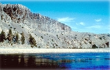
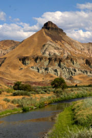
. It flows through exceptionally scenic canyons in its upper course, with several significant paleontological
Paleontology
Paleontology "old, ancient", ὄν, ὀντ- "being, creature", and λόγος "speech, thought") is the study of prehistoric life. It includes the study of fossils to determine organisms' evolution and interactions with each other and their environments...
sites along its banks.
The main branch of the John Day River rises in the Strawberry Mountains
Strawberry Mountains
The Strawberry Range, also known as the Strawberry Mountains, is a mountain range in the U.S. state of Oregon. It is east of John Day, within Malheur National Forest...
in eastern Grant County
Grant County, Oregon
Grant County is a county located in the U.S. state of Oregon. It is included in the 8 county definition of Eastern Oregon. In 2010, its population was 7,445. It is named for President Ulysses S. Grant, who served as an army officer in the Oregon Territory, and at the time of the county's creation...
, and the four main forks each have their heads in different parts of the Malheur National Forest
Malheur National Forest
The Malheur National Forest is a National Forest in the U.S. state of Oregon. It contains 1.7 million acres in the Blue Mountains of eastern Oregon. The forest include high desert grasslands, sage, juniper, pine, fir, and other tree species. Elevations vary from about 4000 feet to the 9038...
. The main fork flows initially north, then west through the John Day Valley and through the city of John Day
John Day, Oregon
John Day is a city located about north of Canyon City in Grant County, Oregon, at the intersection of U.S. Routes 26 and 395. The city was named for the nearby John Day River, which had been named for a Virginian member of the 1811 Astor Expedition, John Day...
. At Dayville
Dayville, Oregon
Dayville is a city in Grant County, Oregon, United States. It was incorporated in 1913. The population was 138 at the 2000 census.-Geography:According to the United States Census Bureau, the city has a total area of , all land....
in western Grant County it is joined from the south by the South Fork John Day River
South Fork John Day River
The South Fork John Day River is a tributary of the John Day River in the U.S. state of Oregon. It begins in the Malheur National Forest in Harney County about north-northwest of Burns and flows generally north to Dayville, where it meets the main stem of the John Day River. Along the way, the...
, then flows north through Picture Gorge and past the Sheep Rock Unit of the John Day Fossil Beds National Monument
John Day Fossil Beds National Monument
John Day Fossil Beds National Monument is a U.S. National Monument in Wheeler and Grant counties in east-central Oregon. Located within the John Day River basin and managed by the National Park Service, the park is known for its well-preserved layers of fossil plants and mammals that lived in the...
.
At Kimberly
Kimberly, Oregon
Kimberly is an unincorporated community in Grant County, Oregon, United States. It is located at the intersection of Oregon Route 19 and Oregon Route 402 and the confluence of the John Day and the North Fork John Day rivers....
in northwestern Grant County, it is joined from the east by the North Fork John Day River
North Fork John Day River
The North Fork John Day River is a tributary of the John Day River in the U.S. state of Oregon. It begins in Grant County about northwest of Baker City near the crest of the Blue Mountains. It flows generally west to the community of Dale on U.S...
(which had already joined with the Middle Fork John Day River
Middle Fork John Day River
The Middle Fork John Day River is a tributary of the North Fork John Day River in the U.S. state of Oregon. It originates in the Blue Mountains of northeast Oregon in the Malheur National Forest near Austin and flows generally west to the North Fork about above Monument...
above Monument, Grant County, Oregon). The river then flows west across Wheeler County
Wheeler County, Oregon
As of the census of 2000, there were 1,547 people, 653 households, and 444 families residing in the county. The population density was 1 people per square mile . There were 842 housing units at an average density of 0 per square mile...
. At the county line with Jefferson County
Jefferson County, Oregon
Jefferson County is a county located in the U.S. state of Oregon. In 2010, its population was 21,720. It is named after Mount Jefferson. The seat of the county is Madras.-History:...
it flows north, past the Clarno Unit of the John Day Fossil Beds National Monument. As it approaches the Columbia River in north-central Oregon it flows in an increasingly meandering course, forming the boundary between Sherman County
Sherman County, Oregon
Sherman County is a county located in the U.S. state of Oregon. The county is named for William Tecumseh Sherman, a Union general in the American Civil War. In 2010, its population was 1,765. The seat of the county is Moro. The largest city is Wasco....
to the west and Gilliam County
Gilliam County, Oregon
-Demographics:As of the census of 2000, there were 1,915 people, 819 households, and 543 families residing in the county. The population density was 2 people per square mile . There were 1,043 housing units at an average density of 1 per square mile...
to the east.
It joins the Columbia from the southeast approximately 16 miles (26 km) northeast of Biggs
Biggs Junction, Oregon
Biggs Junction is an unincorporated community in Sherman County, Oregon, United States. For statistical purposes, the United States Census Bureau has defined Biggs Junction as a census-designated place...
. The mouth of the river is on the narrow Lake Umatilla
Lake Umatilla
Lake Umatilla is a long reservoir on the Columbia River in the United States, between the U.S. states of Washington and Oregon. It was created in 1971 with the construction of John Day Dam, and stretches upstream to the McNary Dam. It lies in parts of Sherman, Gilliam, Morrow, and Umatilla...
reservoir, formed on the Columbia by the John Day Dam
John Day Dam
The John Day Dam is a concrete gravity run-of-the-river dam spanning the Columbia River in the northwestern United States. The dam features a navigation lock plus fish ladders on both sides. The John Day Lock has the highest lift of any U.S. lock...
, approximately 2 miles (3.2 km) downstream from the mouth of the John Day.
Recreation and ecosystem
United States Congress
The United States Congress is the bicameral legislature of the federal government of the United States, consisting of the Senate and the House of Representatives. The Congress meets in the United States Capitol in Washington, D.C....
designated 147.5 miles (237.4 km) of the river from Service Creek
Service Creek, Oregon
Service Creek is an unincorporated community in Wheeler County, in the U.S. state of Oregon. Service Creek lies on Oregon Route 19 near its intersection with Oregon Route 207. It is also near the mouth of a stream, Service Creek, formerly Sarvis Creek, that empties into the John Day River.A...
to Tumwater Falls as the John Day Wild and Scenic River, as part of the National Wild and Scenic River
National Wild and Scenic River
National Wild and Scenic River is a designation for certain protected areas in the United States.The National Wild and Scenic Rivers Act was an outgrowth of the recommendations of a Presidential commission, the Outdoor Recreation Resources Review Commission...
program. The segment of the river is a popular destination for anadromous steelhead
Rainbow trout
The rainbow trout is a species of salmonid native to tributaries of the Pacific Ocean in Asia and North America. The steelhead is a sea run rainbow trout usually returning to freshwater to spawn after 2 to 3 years at sea. In other words, rainbow trout and steelhead trout are the same species....
and warm water bass
Bass (fish)
Bass is a name shared by many different species of popular gamefish. The term encompasses both freshwater and marine species. All belong to the large order Perciformes, or perch-like fishes, and in fact the word bass comes from Middle English bars, meaning "perch."-Types of basses:*The temperate...
fishing, as well as whitewater rafting.
In addition to wild spring chinook salmon
Chinook salmon
The Chinook salmon, Oncorhynchus tshawytscha, is the largest species in the pacific salmon family. Other commonly used names for the species include King salmon, Quinnat salmon, Spring salmon and Tyee salmon...
and bass, the river furnishes habitat for redband trout
Redband trout
Redband trout is a fish name that may be a synonym for the rainbow trout, Oncorhynchus mykiss, but is also used more narrowly for inland subspecies with well-defined geographical distributions in the United States...
, bull trout
Bull trout
The bull trout, Salvelinus confluentus, is a char of the family Salmonidae native to northwestern North America. Historically, S. confluentus has been known as the "Dolly Varden" , but was re-classified as a separate species in 1980. Bull trout are listed as a threatened species under the U.S....
, and westslope cutthroat trout
Westslope cutthroat trout
The westslope cutthroat trout , also known as the blackspotted cutthroat, is a subspecies of the cutthroat trout and is a freshwater fish in the salmon family of order Salmoniformes. The cutthroat is the Montana state fish...
. There are no hatchery salmon or steelhead released in the John Day River.
See also
- List of rivers of Oregon
- List of longest streams of Oregon
- List of National Wild and Scenic Rivers
- Lost Blue Bucket MineLost Blue Bucket MineThe Lost Blue Bucket Mine is a lost mine reputed to be located along the Meek Wagon Train trail between the present day cities of Vale and The Dalles in Oregon, United States...
, a lost mine believed to be somewhere on the John Day