
Tuolumne River
Encyclopedia
The Tuolumne River is a California river that flows nearly 150 miles (241.4 km) from the central Sierra Nevada (U.S.) to the San Joaquin River
in the Central Valley. The river flows from the Sierra Crest
on the west Sierra slope, through the Sierra foothills of the Sierra Nevada, to Don Pedro Reservoir, through farmland in the Central Valley, to its mouth near Modesto
.
Slightly larger than its counterpart in the south, the Merced River
, the Tuolumne River's upper watershed was shaped by glaciations in the previous Ice Age
, which produced Hetch Hetchy Valley
and the Grand Canyon of the Tuolumne
. The river has been a source of controversy for many years, especially from Hetch Hetchy Valley. Much of its water is now diverted to San Francisco from Hetch Hetchy Reservoir
, which fills the valley in the Sierra Nevada once compared to famous Yosemite Valley
. More water is diverted from La Grange Diversion Dam to irrigate farmland in the Central Valley, which leaves the lower course of the river with less than 60% of its historic flow. Despite these extensive water system developments, the Tuolumne is still a popular area in Yosemite National Park, although far less visited than the Merced River.
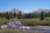
 The Tuolumne headwaters are along ~35 mi (56.3 km) of the Sierra Crest
from the triple watershed point with the Stanislaus River
southward over Mount Dana
and the triple point for the Dana & Lyell Forks (37.818056°N 119.217238°W) to the Upper San Joaquin triple point near Mount Lyell. The Tuolumne source is the confluence of the Dana Fork (from Mount Dana
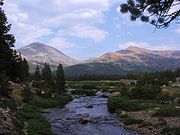
) and the Lyell Fork (from Mount Lyell) in the Tuolumne Meadows
. After the subsequent confluence with Cold Canyon & Conness Creek, the Tuolumne flows through Glen Aulin
(Gaelic: beautiful valley) where the valley walls pull away from each other and become steeper and the meandering riverbed is quite level and forms deep pools. Just northwest of Glen Aulin, the River presents spectacular waterfalls, including LeConte Falls and Waterwheel Falls
, both known for the "waterwheel" phenomenon whereby descending water hits rocks below and wheels back upward.
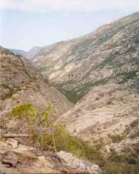 At this point, the Tuolumne enters the Grand Canyon of the Tuolumne
. This canyon is a deep, roughly 'V'-shaped gorge. The walls are not as steep and bare as those of Yosemite Valley
. The flora of the valley bottom is a haphazard melange of chaparral
, manzanita
scrub and oak
woodland characteristic of the foothills and lowlands with a coniferous forest reminiscent of (but different from) that found above the canyon rim. This vegetation clings and clambers up every ledge of the valley walls to the top, giving it a lusher appearance than Yosemite Valley, though this area in fact experiences a drier climate. Class IV whitewater is in an 18-mile section from Meral's Pool to Ward's Ferry Bridge.
 Below the Grand Canyon lies Hetch Hetchy Valley
. The river bottom flattens again, and the canyon walls pull away and become steeper, in a fashion similar to that of Yosemite Valley
; this valley was once perhaps the most spectacular part of the Tuolumne's course. However, at the bottom of Hetch Hetchy Valley stands O'Shaughnessy Dam
, which floods the entire valley under the Hetch Hetchy Reservoir
. Before the river leaves the dam, Falls Creek
, Tiltill Creek and Rancheria Creek enter from the right. Below the dam, the river flows through the Stanislaus National Forest
, within which it is joined by Cherry Creek, the South Fork of the Tuolumne River, and the Middle Fork of the Tuolumne River. Far below the town of Groveland
, the river is designated Wild and Scenic
. This portion is popular for rafting
and kayaking
and is joined by the Clavey River
.
Still farther downstream lie Don Pedro Dam
and Don Pedro Reservoir. These reservoirs provide electricity
and divert water to serve farms in the Modesto Irrigation District and Turlock Irrigation District, and cities in the San Francisco Bay Area
.
Towns along the Tuolumne River:
Cities along the Tuolumne River:
The Modesto Airport lies next to the Tuolumne River. Between the airport and the river lies Veterans' Park.
San Joaquin River
The San Joaquin River is the largest river of Central California in the United States. At over long, the river starts in the high Sierra Nevada, and flows through a rich agricultural region known as the San Joaquin Valley before reaching Suisun Bay, San Francisco Bay, and the Pacific Ocean...
in the Central Valley. The river flows from the Sierra Crest
Sierra Crest
The Sierra Crest is a ~ generally north-to-south ridgeline that demarcates the broad west and narrow east slopes of the Sierra Nevada and that extends as far east as the Sierra's topographic front...
on the west Sierra slope, through the Sierra foothills of the Sierra Nevada, to Don Pedro Reservoir, through farmland in the Central Valley, to its mouth near Modesto
Modesto, California
Modesto is a city in, and is the county seat of, Stanislaus County, California. With a population of approximately 201,165 at the 2010 census, Modesto ranks as the 18th largest city in the state of California....
.
Slightly larger than its counterpart in the south, the Merced River
Merced River
The Merced River , in the central part of the U.S. state of California, is a -long tributary of the San Joaquin River flowing from the Sierra Nevada into the Central Valley. It is most well known for its swift and steep course through the southern part of Yosemite National Park, and the...
, the Tuolumne River's upper watershed was shaped by glaciations in the previous Ice Age
Ice age
An ice age or, more precisely, glacial age, is a generic geological period of long-term reduction in the temperature of the Earth's surface and atmosphere, resulting in the presence or expansion of continental ice sheets, polar ice sheets and alpine glaciers...
, which produced Hetch Hetchy Valley
Hetch Hetchy Valley
Hetch Hetchy Valley is a glacial valley in Yosemite National Park in California. It is currently completely flooded by O'Shaughnessy Dam, forming the Hetch Hetchy Reservoir. The Tuolumne River fills the reservoir. Upstream from the valley lies the Grand Canyon of the Tuolumne. The reservoir...
and the Grand Canyon of the Tuolumne
Grand Canyon of the Tuolumne
The Grand Canyon of the Tuolumne is the portion of the valley of the Tuolumne River in Yosemite National Park, USA. As defined by the United States Geological Survey, it begins immediately below Tuolumne Meadows and ends immediately above Hetch Hetchy Valley.The Tuolumne River runs as a somewhat...
. The river has been a source of controversy for many years, especially from Hetch Hetchy Valley. Much of its water is now diverted to San Francisco from Hetch Hetchy Reservoir
Hetch Hetchy Reservoir
Hetch Hetchy Reservoir is a reservoir in Yosemite National Park, about northeast from the city of Merced, California. The reservoir has a capacity of and is formed by the concrete gravity O'Shaughnessy Dam in Hetch Hetchy Valley on the Tuolumne River...
, which fills the valley in the Sierra Nevada once compared to famous Yosemite Valley
Yosemite Valley
Yosemite Valley is a glacial valley in Yosemite National Park in the western Sierra Nevada mountains of California, carved out by the Merced River. The valley is about long and up to a mile deep, surrounded by high granite summits such as Half Dome and El Capitan, and densely forested with pines...
. More water is diverted from La Grange Diversion Dam to irrigate farmland in the Central Valley, which leaves the lower course of the river with less than 60% of its historic flow. Despite these extensive water system developments, the Tuolumne is still a popular area in Yosemite National Park, although far less visited than the Merced River.
Course
Sierra Crest
The Sierra Crest is a ~ generally north-to-south ridgeline that demarcates the broad west and narrow east slopes of the Sierra Nevada and that extends as far east as the Sierra's topographic front...
from the triple watershed point with the Stanislaus River
Stanislaus River
The Stanislaus River in California is one of the largest tributaries of the San Joaquin River. The river is long and has north, middle and south forks...
southward over Mount Dana
Mount Dana
Mount Dana is a mountain on the eastern edge of Yosemite National Park in the U.S. state of California. At an elevation of , it is the second highest mountain in Yosemite . Mount Dana is the highest peak in Yosemite that is a simple hike to the summit...
and the triple point for the Dana & Lyell Forks (37.818056°N 119.217238°W) to the Upper San Joaquin triple point near Mount Lyell. The Tuolumne source is the confluence of the Dana Fork (from Mount Dana
Mount Dana
Mount Dana is a mountain on the eastern edge of Yosemite National Park in the U.S. state of California. At an elevation of , it is the second highest mountain in Yosemite . Mount Dana is the highest peak in Yosemite that is a simple hike to the summit...
) and the Lyell Fork (from Mount Lyell) in the Tuolumne Meadows
Tuolumne Meadows
Tuolumne Meadows is a gentle, dome-studded sub-alpine meadowy section of the Tuolumne River, in the eastern section of Yosemite National Park. Its approximate location is . Its approximate elevation is 8619 feet .-Natural History:...
. After the subsequent confluence with Cold Canyon & Conness Creek, the Tuolumne flows through Glen Aulin
Glen Aulin
Glen Aulin is a segment of the Tuolumne River valley, upriver from the Grand Canyon of the Tuolumne, approximately long. It is located at , at an elevation of approximately .Glen Aulin is home to the Glen Aulin High Sierra Camp....
(Gaelic: beautiful valley) where the valley walls pull away from each other and become steeper and the meandering riverbed is quite level and forms deep pools. Just northwest of Glen Aulin, the River presents spectacular waterfalls, including LeConte Falls and Waterwheel Falls
Waterwheel Falls
Waterwheel Falls is a waterfall in the Sierra Nevada of California, located at in Yosemite National Park. It is the largest of the many waterfalls of the Tuolumne River. Its upper part contains a series of small ledges, each of which creates a small plume as the water is deflected away from the...
, both known for the "waterwheel" phenomenon whereby descending water hits rocks below and wheels back upward.
Grand Canyon of the Tuolumne
The Grand Canyon of the Tuolumne is the portion of the valley of the Tuolumne River in Yosemite National Park, USA. As defined by the United States Geological Survey, it begins immediately below Tuolumne Meadows and ends immediately above Hetch Hetchy Valley.The Tuolumne River runs as a somewhat...
. This canyon is a deep, roughly 'V'-shaped gorge. The walls are not as steep and bare as those of Yosemite Valley
Yosemite Valley
Yosemite Valley is a glacial valley in Yosemite National Park in the western Sierra Nevada mountains of California, carved out by the Merced River. The valley is about long and up to a mile deep, surrounded by high granite summits such as Half Dome and El Capitan, and densely forested with pines...
. The flora of the valley bottom is a haphazard melange of chaparral
Chaparral
Chaparral is a shrubland or heathland plant community found primarily in the U.S. state of California and in the northern portion of the Baja California peninsula, Mexico...
, manzanita
Manzanita
Manzanita is a common name for many species of the genus Arctostaphylos. They are evergreen shrubs or small trees present in the chaparral biome of western North America, where they occur from southern British Columbia, Washington to California, Arizona and New Mexico in the United States, and...
scrub and oak
Oak
An oak is a tree or shrub in the genus Quercus , of which about 600 species exist. "Oak" may also appear in the names of species in related genera, notably Lithocarpus...
woodland characteristic of the foothills and lowlands with a coniferous forest reminiscent of (but different from) that found above the canyon rim. This vegetation clings and clambers up every ledge of the valley walls to the top, giving it a lusher appearance than Yosemite Valley, though this area in fact experiences a drier climate. Class IV whitewater is in an 18-mile section from Meral's Pool to Ward's Ferry Bridge.
Hetch Hetchy Valley
Hetch Hetchy Valley is a glacial valley in Yosemite National Park in California. It is currently completely flooded by O'Shaughnessy Dam, forming the Hetch Hetchy Reservoir. The Tuolumne River fills the reservoir. Upstream from the valley lies the Grand Canyon of the Tuolumne. The reservoir...
. The river bottom flattens again, and the canyon walls pull away and become steeper, in a fashion similar to that of Yosemite Valley
Yosemite Valley
Yosemite Valley is a glacial valley in Yosemite National Park in the western Sierra Nevada mountains of California, carved out by the Merced River. The valley is about long and up to a mile deep, surrounded by high granite summits such as Half Dome and El Capitan, and densely forested with pines...
; this valley was once perhaps the most spectacular part of the Tuolumne's course. However, at the bottom of Hetch Hetchy Valley stands O'Shaughnessy Dam
O'Shaughnessy Dam
The O'Shaughnessy Dam is a curved gravity dam on the Tuolumne River in the Hetch Hetchy Valley of California's Sierra Nevada. The dam is located in Yosemite National Park, and creates the Hetch Hetchy Reservoir. It is named for former San Francisco chief engineer and the original chief engineer of...
, which floods the entire valley under the Hetch Hetchy Reservoir
Hetch Hetchy Reservoir
Hetch Hetchy Reservoir is a reservoir in Yosemite National Park, about northeast from the city of Merced, California. The reservoir has a capacity of and is formed by the concrete gravity O'Shaughnessy Dam in Hetch Hetchy Valley on the Tuolumne River...
. Before the river leaves the dam, Falls Creek
Falls Creek (California)
Falls Creek, also known as the Falls River, is a tributary of the Tuolumne River in Yosemite National Park, California, United States. The creek begins at the northern boundary of the national park and flows to empty into the Tuolumne at Hetch Hetchy Reservoir, dropping over two well-known...
, Tiltill Creek and Rancheria Creek enter from the right. Below the dam, the river flows through the Stanislaus National Forest
Stanislaus National Forest
Stanislaus National Forest contains in four counties in the Sierra Nevada Mountains of Northern California. It was established on February 22, 1897, making it one of the oldest national forests...
, within which it is joined by Cherry Creek, the South Fork of the Tuolumne River, and the Middle Fork of the Tuolumne River. Far below the town of Groveland
Groveland, California
Groveland is a census-designated place in Tuolumne County, California. Groveland sits at an elevation of . The 2010 United States census reported Groveland's population was 601....
, the river is designated Wild and Scenic
National Wild and Scenic River
National Wild and Scenic River is a designation for certain protected areas in the United States.The National Wild and Scenic Rivers Act was an outgrowth of the recommendations of a Presidential commission, the Outdoor Recreation Resources Review Commission...
. This portion is popular for rafting
Rafting
Rafting or white water rafting is a challenging recreational outdoor activity using an inflatable raft to navigate a river or other bodies of water. This is usually done on white water or different degrees of rough water, in order to thrill and excite the raft passengers. The development of this...
and kayaking
Kayaking
Kayaking is the use of a kayak for moving across water. Kayaking and canoeing are also known as paddling. Kayaking is distinguished from canoeing by the sitting position of the paddler and the number of blades on the paddle...
and is joined by the Clavey River
Clavey River
The Clavey River is a tributary of the Tuolumne River, about long, located in Tuolumne County, California. The Clavey's headwaters originate in the Emigrant Wilderness in the Stanislaus National Forest. Uniquely, it flows north-south, which is exceptional for a west-slope river in the Sierra...
.
Still farther downstream lie Don Pedro Dam
Don Pedro Dam
The Don Pedro Dam, since 1971 also known as the Old Don Pedro Dam, was a dam across the Tuolumne River in Tuolumne County, California. The structure is currently flooded underneath Don Pedro Reservoir, which is formed by the New Don Pedro Dam....
and Don Pedro Reservoir. These reservoirs provide electricity
Electricity
Electricity is a general term encompassing a variety of phenomena resulting from the presence and flow of electric charge. These include many easily recognizable phenomena, such as lightning, static electricity, and the flow of electrical current in an electrical wire...
and divert water to serve farms in the Modesto Irrigation District and Turlock Irrigation District, and cities in the San Francisco Bay Area
San Francisco Bay Area
The San Francisco Bay Area, commonly known as the Bay Area, is a populated region that surrounds the San Francisco and San Pablo estuaries in Northern California. The region encompasses metropolitan areas of San Francisco, Oakland, and San Jose, along with smaller urban and rural areas...
.
Towns along the Tuolumne River:
- La GrangeLa Grange, CaliforniaLa Grange is a small unincorporated community in rural Stanislaus County, California, United States. Its altitude is 249 feet. As of 2008 it has a population of 345. , and it is located at .-History:...
- EmpireEmpire, CaliforniaEmpire is a census-designated place in Stanislaus County, California, United States. The population was 4,189 at the 2010 census, up from 3,903 at the 2000 census. It is part of the Modesto Metropolitan Statistical Area...
Cities along the Tuolumne River:
- WaterfordWaterford, CaliforniaWaterford, California is the eighth largest city in Stanislaus County, California, United States. The population was 8,456 at the 2010 census, up from 6,924 as of the 2000 census...
- HughsonHughson, CaliforniaHughson is a city in Stanislaus County, California, United States. It is part of the Modesto Metropolitan Statistical Area. The population was 6,640 at the 2010 census, up from 3,980 at the 2000 census.-History of farming:...
- CeresCeres, CaliforniaCeres is a city in Stanislaus County, California, United States. The population was 45,417 at the 2010 census, up from 34,609 at the 2000 census. It is part of the Modesto Metropolitan Statistical Area.-General:...
- ModestoModesto, CaliforniaModesto is a city in, and is the county seat of, Stanislaus County, California. With a population of approximately 201,165 at the 2010 census, Modesto ranks as the 18th largest city in the state of California....
The Modesto Airport lies next to the Tuolumne River. Between the airport and the river lies Veterans' Park.