

Ottawa River
Encyclopedia
The Ottawa River is a river
in the Canadian provinces of Ontario
and Quebec
. For most of its length, it now defines the border between these two provinces.
of central Quebec, and flows west to Lake Timiskaming
. From there its route has been used to define the interprovincial border with Ontario.
From Lake Timiskaming, the river flows southeast to Ottawa
and Gatineau
, where it tumbles over the Chaudière Falls
and further takes in the Rideau
and Gatineau
rivers.
The Ottawa River drains into the Lake of Two Mountains and the St. Lawrence River at Montreal
. The total length of the river is 1271 kilometres (789.8 mi); it drains an area of 146,300 km2, 65% in Quebec and the rest in Ontario, with a mean discharge of 1,950 m3/s.
The average annual mean waterflow measured at Carillon dam
, near the Lake of Two Mountains, is 1,939 m3/s, with average annual extremes of 749 to 5,351 m3/s. Record historic levels since 1964 are a low of 529 in 2005 and a high of 8190 m3/s in 1976.
Major tributaries include:
 communities along the Ottawa River include (in down-stream order):
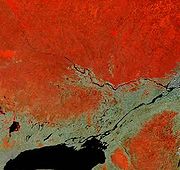
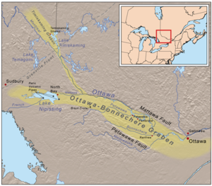 The Ottawa River lies in the Ottawa-Bonnechere Graben
, which is a Mesozoic
rift valley
that formed 175 million years ago. Following the retreat of the glacier
s from the area at the end of the last ice age
, the valley was flooded by an arm of the Atlantic Ocean
known as the Champlain Sea
. Fossil remains of marine life have been found in marine clay
formed during that time. Sediment deposits from this period have resulted in areas of poor drainage and the presence of large bog
s in some ancient channels of this river. Another consequence was the formations of large deposits of a material commonly known as Leda clay
; these deposits become highly unstable after heavy rains. Numerous landslide
s have occurred as a result. The former site of the town of Lemieux, Ontario
collapsed into the South Nation River
in 1993; however, the residents had already been relocated because of the suspected instability of the earth in that location.
Large numbers of Canada Geese
, ducks, gull
s and shorebird
s take advantage of spring flooding and wetlands in the Ottawa River valley during migration. Ducks also overwinter in sections of the river that do not freeze over.
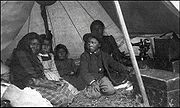 As it does to this day, the river played a vital role in life of the Algonquin people, who lived throughout its watershed at contact. The river is called Kichisìpi, meaning "Great River" in Anicinàbemowin
, the Algonquin language. The Algonquin define themselves in terms of their position on the river, referring to themselves as the Omàmiwinini, 'down-river people'. Although a majority of the Algonquin First Nation lives in Quebec, the entire Ottawa Valley is Algonquin traditional territory. Present settlement is a result of adaptations made as a result of settler pressures.
 Some early European explorers, possibly considering the Ottawa River to be more significant than the Upper St. Lawrence River, applied the name River Canada to the Ottawa River and the St. Lawrence River below the confluence at Montreal. As the extent of the Great Lakes
became clear and the river began to be regarded as a tributary, it was variously known as the Grand River, "Great River" or Grand River of the Algonquins before the present name was settled upon. This name change resulted from the Ottawa people
s' control of the river circa 1685. However, only one band of Ottawa, the Kinouncherpirini or Keinouch, ever inhabited the Ottawa Valley
.
In 1615, Samuel de Champlain
and Étienne Brûlé
, assisted by Algonquin guides, were the first Europeans to travel up the Ottawa River and follow the water route west along the Mattawa
and French Rivers
to the Great Lakes
. See Canadian Canoe Routes (early)
. For the following two centuries, this route was used by French
fur trade
rs, Voyageurs
and Coureur des bois
to Canada's interior. The river posed serious hazards to these travelers. The section near Deux Rivières
used to have spectacular and wild rapids, namely the Rapide de la Veillée, the Trou, the Rapide des Deux Rivières, and the Rapide de la Roche Capitaine. In 1800, explorer Daniel Harmon reported 14 crosses marking the deaths of voyageurs who had drowned in the dangerous waters along this section of the Ottawa.
In the early 19th century, the Ottawa River and its tributaries were used to gain access to large virgin forests of white pine
. A booming trade in timber developed, and large rafts of logs
were floated down the river. A scattering of small subsistence farming communities developed along the shores of the river to provide manpower for the lumber camps in winter. In 1832, following the War of 1812
, the Ottawa River gained strategic importance when the Carillon Canal
was completed. Together with the Rideau Canal
, the Carillon Canal was constructed to provide an alternate military supply route to Kingston
and Lake Ontario
, bypassing the route along the Saint Lawrence River
.
dams have been constructed on the river. In 1950, the dam at Rapides-des-Joachims
, was built, forming Holden Lake behind it and thereby submerging the rapids and portages at Deux Rivières. As an economic route, its importance was eclipsed by railroad and highways in the 20th century. It is no longer used for log driving, however, it is still extensively used for recreational boating. Some 20,000 pleasure boaters visit the Carillon Canal annually.
Today, Outaouais Herald Emeritus
at the Canadian Heraldic Authority
is named after the river.
Lower Ottawa (in downstream order):
* Ontario Power Generation operates generators 2, 3, 4, and 5 with a capacity of 96 MW; and Hydro-Québec operates generators 6, 7, 8, and 9 with a capacity of 89 MW.
River
A river is a natural watercourse, usually freshwater, flowing towards an ocean, a lake, a sea, or another river. In a few cases, a river simply flows into the ground or dries up completely before reaching another body of water. Small rivers may also be called by several other names, including...
in the Canadian provinces of Ontario
Ontario
Ontario is a province of Canada, located in east-central Canada. It is Canada's most populous province and second largest in total area. It is home to the nation's most populous city, Toronto, and the nation's capital, Ottawa....
and Quebec
Quebec
Quebec or is a province in east-central Canada. It is the only Canadian province with a predominantly French-speaking population and the only one whose sole official language is French at the provincial level....
. For most of its length, it now defines the border between these two provinces.
Geography
The river rises from its source in Lake Capimitchigama, in the Laurentian MountainsLaurentian mountains
The Laurentian Mountains are a mountain range in southern Quebec, Canada, north of the St. Lawrence River and Ottawa River, rising to a highest point of 1166 metres at Mont Raoul Blanchard, north east of Quebec City in the Reserve Faunique des Laurentides. The Gatineau, L'Assomption, Lièvre,...
of central Quebec, and flows west to Lake Timiskaming
Lake Timiskaming
Lake Timiskaming is a large freshwater lake on the provincial border between Ontario and Quebec, Canada. The lake, which forms part of the Ottawa River, is in length and covers an area of almost . Its water level ranges between and above sea-level, with a mean annual average of . The lake is...
. From there its route has been used to define the interprovincial border with Ontario.
From Lake Timiskaming, the river flows southeast to Ottawa
Ottawa
Ottawa is the capital of Canada, the second largest city in the Province of Ontario, and the fourth largest city in the country. The city is located on the south bank of the Ottawa River in the eastern portion of Southern Ontario...
and Gatineau
Gatineau
Gatineau is a city in western Quebec, Canada. It is the fourth largest city in the province. It is located on the northern banks of the Ottawa River, immediately across from Ottawa, Ontario, and together they form Canada's National Capital Region. Ottawa and Gatineau comprise a single Census...
, where it tumbles over the Chaudière Falls
Chaudière Falls
The Chaudière Falls are a set of cascades and waterfall in the centre of the Ottawa-Gatineau metropolitan area in Canada where the Ottawa River narrows between a rocky escarpment on both sides of the river. The location is just west of the Chaudière Bridge, northwest of the Canadian War Museum at...
and further takes in the Rideau
Rideau River
thumb|Rapids on the Rideau River opposite [[Carleton University]].The Rideau River is a Southern Ontario river which flows north from Upper Rideau Lake and empties into the Ottawa River at Rideau Falls in Ottawa, Ontario. Its length is 146 km...
and Gatineau
Gatineau River
The Gatineau River is a river in western Quebec, Canada, which rises in lakes north of the Baskatong Reservoir and flows south to join the Ottawa River at the city of Gatineau, Quebec...
rivers.
The Ottawa River drains into the Lake of Two Mountains and the St. Lawrence River at Montreal
Montreal
Montreal is a city in Canada. It is the largest city in the province of Quebec, the second-largest city in Canada and the seventh largest in North America...
. The total length of the river is 1271 kilometres (789.8 mi); it drains an area of 146,300 km2, 65% in Quebec and the rest in Ontario, with a mean discharge of 1,950 m3/s.
The average annual mean waterflow measured at Carillon dam
Carillon Generating Station
The Carillon Generating Station is a hydroelectric power station on the Ottawa River near Carillon, Quebec, Canada. Built between 1959 and 1964, it is managed and operated by Hydro-Québec. It is a run-of-river generating station with an installed capacity of 752 MW, a head of , and a reservoir of...
, near the Lake of Two Mountains, is 1,939 m3/s, with average annual extremes of 749 to 5,351 m3/s. Record historic levels since 1964 are a low of 529 in 2005 and a high of 8190 m3/s in 1976.
Major tributaries include:
- Bonnechere RiverBonnechere RiverThe Bonnechere River is a river in the Saint Lawrence River drainage basin in Nipissing District and Renfrew County in eastern and northeastern Ontario, Canada. The river flows from Algonquin Provincial Park to the Ottawa River east and north of the town of Renfrew...
- Coulonge RiverCoulonge RiverThe Coulonge River is a predominantly wilderness river in western Quebec, Canada. It is 217 km long, has a drainage area of 5060 km² , and runs in a general south-eastern direction from its headwaters in Lac au Barrage to the Ottawa River at Fort-Coulonge, Quebec...
- Dumoine RiverDumoine RiverThe Dumoine River is a river in western Quebec with its source in Machin Lake near La Vérendrye Wildlife Reserve. From Dumoine Lake, the river flows almost due south off the Canadian Shield and empties into the Ottawa River, just west of Rapides-des-Joachims, Quebec, or Rolphton, Ontario...
- Gatineau RiverGatineau RiverThe Gatineau River is a river in western Quebec, Canada, which rises in lakes north of the Baskatong Reservoir and flows south to join the Ottawa River at the city of Gatineau, Quebec...
- Kipawa RiverKipawa RiverThe Kipawa River is a short river in western Quebec, Canada. It is mostly an undeveloped river but the larger lakes have dams, fishing camps, and cottages on their shores. The communities of Kipawa and Laniel are located on Lake Kipawa. Also much logging takes place within its watershed basin,...
- du Lièvre RiverDu Lièvre RiverThe du Lièvre River is a river in western Quebec which flows south from the Mitchinamécus reservoir and empties into the Ottawa River at Masson-Angers. The river is 330 km in length and drains an area of 10,400 km²...
- Madawaska RiverMadawaska River (Ontario)The Madawaska River is a river in Ontario, Canada. The river is long and drains an area of . It originates at Source Lake in the highlands of Algonquin Park at an elevation of and flows east, dropping before emptying into the Ottawa River at Arnprior....
- Mattawa RiverMattawa RiverThe Mattawa River is a river in central Ontario, Canada. It flows east from Trout Lake east of North Bay and enters the Ottawa River at the town of Mattawa. Counting from the head of Trout Lake, it is 76 km in length...
- Mississippi RiverMississippi River (Ontario)The Mississippi River is a tributary of the Ottawa River in eastern Ontario in Canada. It is in length from its source in Upper Mazinaw Lake, has a drainage area of , and has a mean discharge of...
- Montreal RiverMontreal River (Timiskaming District, Ontario)The Montreal River is a river in Timiskaming District, Ontario, Canada. It travels from its source at Smoothwater Lake to its mouth at Lake Timiskaming on the Ottawa River. The river is a significant source of hydroelectricity.-Course:...
- Rivière du NordRivière du Nord (Laurentides)Rivière du Nord is a river in the Laurentides region that flows into the Ottawa River. The oldest bridge over the river was constructed by William Shaw near the village of Shawbridge, now part of the town of Prévost....
- Noire RiverNoire RiverThe Noire River is a river in western Quebec, Canada. It runs in a south-eastern direction into the Ottawa River at Waltham, Quebec. It is named after the dark colour of its water ....
- Petawawa RiverPetawawa RiverThe Petawawa River is a river in the Saint Lawrence River drainage basin in Nipissing District and Renfrew County in eastern and northeastern Ontario, Canada. The river flows from Algonquin Provincial Park to the Ottawa River at the town of Petawawa...
- Rideau RiverRideau Riverthumb|Rapids on the Rideau River opposite [[Carleton University]].The Rideau River is a Southern Ontario river which flows north from Upper Rideau Lake and empties into the Ottawa River at Rideau Falls in Ottawa, Ontario. Its length is 146 km...
- Rouge RiverRouge River (Quebec)The Rouge River is a river in western Quebec, Canada,which empties into the Ottawa River near Pointe-au-Chêne and flows north of Mont Tremblant.It is located in the Laurentides,about halfway between...
- South Nation RiverSouth Nation RiverThe South Nation River is a river in Eastern Ontario, Canada. It springs from forests and marshes located north of Brockville and it flows 175 km northeast to empty into the Ottawa River north of Plantagenet...
|
Gatineau Gatineau is a city in western Quebec, Canada. It is the fourth largest city in the province. It is located on the northern banks of the Ottawa River, immediately across from Ottawa, Ontario, and together they form Canada's National Capital Region. Ottawa and Gatineau comprise a single Census... Orléans, Ontario Orleans , also written Orléans, is a suburban area within the city of Ottawa, Ontario, Canada. It is located in the eastern part of the city along the Ottawa River, about from downtown Ottawa. The Canada 2006 Census gave Orleans a population of 95,491. It became a ward of the City of Ottawa in 2001... Masson-Angers, Quebec Masson-Angers is a former municipality and now a sector within the City of Gatineau, located on the north shore of the Ottawa River, in Quebec, Canada, approximately northeast of downtown Ottawa.-History:... Clarence-Rockland, Ontario Clarence-Rockland is a city in Eastern Ontario, Canada, in the United Counties of Prescott and Russell on the Ottawa River. Clarence-Rockland is located immediately to the east of Ottawa and is considered part of Canada's National Capital Region in the census.... Thurso, Quebec Thurso is a city in the Papineau Regional County Municipality in the Outaouais region of western Quebec. It is located on the Ottawa River, and is within Canada's National Capital Region... Plaisance, Quebec Plaisance is a village located in the Regional County Municipality of Papineau in western Quebec. The village is situated on the Ottawa River near the mouth of the Petite-Nation River, 70 km from Gatineau and 160 km from Montreal on Route 148.... Papineauville, Quebec Papineauville is a town and municipality in the Outaouais region of Quebec, Canada. It is the seat of the Papineau Regional County Municipality and part of Canada's National Capital Region... Montebello, Quebec Montebello is a municipality located in the Papineau Regional County Municipality of Western Quebec . As of the 2001 census, there were 1,039 permanent residents. The village has a total area of , and is located at the eastern edge of Canada's National Capital Region.The village is world famous for... Fassett, Quebec Fassett is a municipality and village in the Papineau Regional County Municipality in Quebec, Canada, located on the north shore of the Ottawa River east of Montebello.Its main access road is Route 148... L'Orignal, Ontario L'Orignal is a village and former municipality, now part of Champlain Township in eastern Ontario, Canada. It likely took its name from its location on the Ottawa River once known as Pointe à l'Orignal , where moose crossed the river.-History:The Seigniory of L'Orignal , was granted by the Company... Grenville, Quebec Grenville is a village and municipality in the Argenteuil Regional County Municipality, Quebec, Canada. It is located opposite Hawkesbury, Ontario, on the Ottawa River.-History:... Hawkesbury, Ontario Hawkesbury is a town in the Eastern portion of Southern Ontario, Canada, on the Ottawa River, near the Quebec-Ontario border.It lies on the south shore of the Ottawa River about halfway between Downtown Ottawa and Downtown Montreal in Prescott and Russell Counties. The Long-Sault Bridge links it... Saint-André-d'Argenteuil, Quebec Saint-André-d'Argenteuil is a municipality in the Laurentides region of Quebec, Canada, part of the Argenteuil Regional County Municipality. It is located along the Ottawa River, just south of Lachute.-History:... Saint-André-d'Argenteuil, Quebec Saint-André-d'Argenteuil is a municipality in the Laurentides region of Quebec, Canada, part of the Argenteuil Regional County Municipality. It is located along the Ottawa River, just south of Lachute.-History:... Rigaud, Quebec Rigaud is a municipality in southwestern Quebec, Canada in the county of Vaudreuil-Soulanges at the junction of the Ottawa River and the Rigaud River. The population as of the Canada 2006 Census was 6,780... Saint-Placide, Quebec Saint-Placide is a municipality in the Laurentides region of Quebec, Canada, part of the Deux-Montagnes Regional County Municipality, along the north shore of the Ottawa River.-History:... Hudson, Quebec Hudson, Quebec, Canada, is a town with a population of 5,088 on the south-west bank of the lower Ottawa River, in the Vaudreuil-Soulanges Regional County Municipality. Situated about west of downtown Montreal, many residents commute to work on the Island of Montreal.- Location and... Oka, Quebec -References:... Vaudreuil-sur-le-Lac, Quebec Vaudreuil-sur-le-Lac is a village and municipality in the Montérégie region of Quebec, Canada, part of the Vaudreuil-Soulanges Regional County Municipality. It is located on the western portion of the Vaudreuil Peninsula, which projects into Lake of Two Mountains... Pincourt, Quebec Pincourt is a municipality on the island of Île Perrot, off the western tip of the island of Montreal, Quebec. The population as of the Canada 2006 Census was 11,197. The town shares the island with the three other municipalities of Notre-Dame-de-l'Île-Perrot, Terrasse Vaudreuil and L'Île-Perrot,... Pointe-des-Cascades, Quebec Pointe-des-Cascades is a village and municipality in the Montérégie region of Quebec, Canada, part of the Vaudreuil-Soulanges Regional County Municipality. It is located on a spit of land where the Saint Lawrence River flows into Lake Saint-Louis... |
Geology
Ottawa-Bonnechere Graben
The Ottawa-Bonnechere Graben , with its branch the Timiskaming Graben, is an ancient rift valley in the Canadian Shield of Northeastern Ontario and Quebec, Canada. This rift valley was formed when the Earth's crust moved downward about a kilometre between two major fault zones known as the Mattawa...
, which is a Mesozoic
Mesozoic
The Mesozoic era is an interval of geological time from about 250 million years ago to about 65 million years ago. It is often referred to as the age of reptiles because reptiles, namely dinosaurs, were the dominant terrestrial and marine vertebrates of the time...
rift valley
Rift valley
A rift valley is a linear-shaped lowland between highlands or mountain ranges created by the action of a geologic rift or fault. This action is manifest as crustal extension, a spreading apart of the surface which is subsequently further deepened by the forces of erosion...
that formed 175 million years ago. Following the retreat of the glacier
Glacier
A glacier is a large persistent body of ice that forms where the accumulation of snow exceeds its ablation over many years, often centuries. At least 0.1 km² in area and 50 m thick, but often much larger, a glacier slowly deforms and flows due to stresses induced by its weight...
s from the area at the end of the last ice age
Ice age
An ice age or, more precisely, glacial age, is a generic geological period of long-term reduction in the temperature of the Earth's surface and atmosphere, resulting in the presence or expansion of continental ice sheets, polar ice sheets and alpine glaciers...
, the valley was flooded by an arm of the Atlantic Ocean
Atlantic Ocean
The Atlantic Ocean is the second-largest of the world's oceanic divisions. With a total area of about , it covers approximately 20% of the Earth's surface and about 26% of its water surface area...
known as the Champlain Sea
Champlain Sea
The Champlain Sea was a temporary inlet of the Atlantic Ocean, a paratropical subsea or epeiric sea created by the retreating glaciers during the close of the last ice age...
. Fossil remains of marine life have been found in marine clay
Clay
Clay is a general term including many combinations of one or more clay minerals with traces of metal oxides and organic matter. Geologic clay deposits are mostly composed of phyllosilicate minerals containing variable amounts of water trapped in the mineral structure.- Formation :Clay minerals...
formed during that time. Sediment deposits from this period have resulted in areas of poor drainage and the presence of large bog
Bog
A bog, quagmire or mire is a wetland that accumulates acidic peat, a deposit of dead plant material—often mosses or, in Arctic climates, lichens....
s in some ancient channels of this river. Another consequence was the formations of large deposits of a material commonly known as Leda clay
Quick clay
Quick clay, also known as Leda clay and Champlain Sea clay in Canada, is a unique form of highly sensitive marine clay, with the tendency to change from a relatively stiff condition to a liquid mass when it is disturbed. Undisturbed quick clay resembles a water-saturated gel...
; these deposits become highly unstable after heavy rains. Numerous landslide
Landslide
A landslide or landslip is a geological phenomenon which includes a wide range of ground movement, such as rockfalls, deep failure of slopes and shallow debris flows, which can occur in offshore, coastal and onshore environments...
s have occurred as a result. The former site of the town of Lemieux, Ontario
The Nation, Ontario
The Nation is a municipality in eastern Ontario, located within Canada's National Capital Region, Canada, in the United Counties of Prescott and Russell.The municipality consists of the former geographic townships of Caledonia, Cambridge and South Plantagenet.Cross by the South Nation River that...
collapsed into the South Nation River
South Nation River
The South Nation River is a river in Eastern Ontario, Canada. It springs from forests and marshes located north of Brockville and it flows 175 km northeast to empty into the Ottawa River north of Plantagenet...
in 1993; however, the residents had already been relocated because of the suspected instability of the earth in that location.
Large numbers of Canada Geese
Canada Goose
The Canada Goose is a wild goose belonging to the genus Branta, which is native to arctic and temperate regions of North America, having a black head and neck, white patches on the face, and a brownish-gray body....
, ducks, gull
Gull
Gulls are birds in the family Laridae. They are most closely related to the terns and only distantly related to auks, skimmers, and more distantly to the waders...
s and shorebird
Wader
Waders, called shorebirds in North America , are members of the order Charadriiformes, excluding the more marine web-footed seabird groups. The latter are the skuas , gulls , terns , skimmers , and auks...
s take advantage of spring flooding and wetlands in the Ottawa River valley during migration. Ducks also overwinter in sections of the river that do not freeze over.
History
Algonquin language
Algonquin is either a distinct Algonquian language closely related to the Ojibwe language or a particularly divergent Ojibwe dialect. It is spoken, alongside French and to some extent English, by the Algonquin First Nations of Quebec and Ontario...
, the Algonquin language. The Algonquin define themselves in terms of their position on the river, referring to themselves as the Omàmiwinini, 'down-river people'. Although a majority of the Algonquin First Nation lives in Quebec, the entire Ottawa Valley is Algonquin traditional territory. Present settlement is a result of adaptations made as a result of settler pressures.
Great Lakes
The Great Lakes are a collection of freshwater lakes located in northeastern North America, on the Canada – United States border. Consisting of Lakes Superior, Michigan, Huron, Erie, and Ontario, they form the largest group of freshwater lakes on Earth by total surface, coming in second by volume...
became clear and the river began to be regarded as a tributary, it was variously known as the Grand River, "Great River" or Grand River of the Algonquins before the present name was settled upon. This name change resulted from the Ottawa people
Ottawa (tribe)
The Odawa or Ottawa, said to mean "traders," are a Native American and First Nations people. They are one of the Anishinaabeg, related to but distinct from the Ojibwe nation. Their original homelands are located on Manitoulin Island, near the northern shores of Lake Huron, on the Bruce Peninsula in...
s' control of the river circa 1685. However, only one band of Ottawa, the Kinouncherpirini or Keinouch, ever inhabited the Ottawa Valley
Ottawa Valley
The Ottawa Valley is the valley along the boundary between Eastern Ontario and Western Quebec along the Ottawa River. The valley is the transition between the Saint Lawrence Lowlands and the Canadian Shield...
.
In 1615, Samuel de Champlain
Samuel de Champlain
Samuel de Champlain , "The Father of New France", was a French navigator, cartographer, draughtsman, soldier, explorer, geographer, ethnologist, diplomat, and chronicler. He founded New France and Quebec City on July 3, 1608....
and Étienne Brûlé
Étienne Brûlé
Étienne Brûlé , was the first of European French explorers to journey along the St. Lawrence River with the Native Americans and to view Georgian Bay and Lake Huron Canada in the 17th century. A rugged outdoorsman, he took to the lifestyle of the First Nations and had a unique contribution to the...
, assisted by Algonquin guides, were the first Europeans to travel up the Ottawa River and follow the water route west along the Mattawa
Mattawa River
The Mattawa River is a river in central Ontario, Canada. It flows east from Trout Lake east of North Bay and enters the Ottawa River at the town of Mattawa. Counting from the head of Trout Lake, it is 76 km in length...
and French Rivers
French River (Ontario)
The French River is a river in Central Ontario, Canada. It flows from Lake Nipissing west to Georgian Bay. The river largely follows the boundary between the Parry Sound District and the Sudbury District, and in most contexts is considered the dividing line between Northern Ontario and Southern...
to the Great Lakes
Great Lakes
The Great Lakes are a collection of freshwater lakes located in northeastern North America, on the Canada – United States border. Consisting of Lakes Superior, Michigan, Huron, Erie, and Ontario, they form the largest group of freshwater lakes on Earth by total surface, coming in second by volume...
. See Canadian Canoe Routes (early)
Canadian canoe routes (early)
This article covers the water routes used by early explorers of Canada with special emphasis on the fur trade.-Canada and Siberia:Both Canada and Siberia were explored mainly by river. Both countries have many navigable rivers with short portages between them. There are no serious barriers to canoe...
. For the following two centuries, this route was used by French
France
The French Republic , The French Republic , The French Republic , (commonly known as France , is a unitary semi-presidential republic in Western Europe with several overseas territories and islands located on other continents and in the Indian, Pacific, and Atlantic oceans. Metropolitan France...
fur trade
Fur trade
The fur trade is a worldwide industry dealing in the acquisition and sale of animal fur. Since the establishment of world market for in the early modern period furs of boreal, polar and cold temperate mammalian animals have been the most valued...
rs, Voyageurs
Voyageurs
The Voyageurs were the persons who engaged in the transportation of furs by canoe during the fur trade era. Voyageur is a French word which literally translates to "traveler"...
and Coureur des bois
Coureur des bois
A coureur des bois or coureur de bois was an independent entrepreneurial French-Canadian woodsman who traveled in New France and the interior of North America. They travelled in the woods to trade various things for fur....
to Canada's interior. The river posed serious hazards to these travelers. The section near Deux Rivières
Head, Clara and Maria, Ontario
Head, Clara and Maria is a township in eastern Ontario, Canada, in the County of Renfrew on the Ottawa River. It is on the northern edge of Algonquin Park....
used to have spectacular and wild rapids, namely the Rapide de la Veillée, the Trou, the Rapide des Deux Rivières, and the Rapide de la Roche Capitaine. In 1800, explorer Daniel Harmon reported 14 crosses marking the deaths of voyageurs who had drowned in the dangerous waters along this section of the Ottawa.
In the early 19th century, the Ottawa River and its tributaries were used to gain access to large virgin forests of white pine
Eastern White Pine
Pinus strobus, commonly known as the eastern white pine, is a large pine native to eastern North America, occurring from Newfoundland west to Minnesota and southeastern Manitoba, and south along the Appalachian Mountains to the northern edge of Georgia.It is occasionally known as simply white pine,...
. A booming trade in timber developed, and large rafts of logs
Timber rafting
Timber rafting is a log transportation method in which logs are tied together into rafts and drifted or pulled across a water body or down a flatter river. It is arguably the second cheapest method of transportation of timber, next after log driving...
were floated down the river. A scattering of small subsistence farming communities developed along the shores of the river to provide manpower for the lumber camps in winter. In 1832, following the War of 1812
War of 1812
The War of 1812 was a military conflict fought between the forces of the United States of America and those of the British Empire. The Americans declared war in 1812 for several reasons, including trade restrictions because of Britain's ongoing war with France, impressment of American merchant...
, the Ottawa River gained strategic importance when the Carillon Canal
Carillon Canal
The Carillon Canal is a National Historic Site in Saint-André-d'Argenteuil, Quebec, Canada. It preserves the historic Carillon Canal that was first built in the 1830s to facilitate travel on the Ottawa River...
was completed. Together with the Rideau Canal
Rideau Canal
The Rideau Canal , also known as the Rideau Waterway, connects the city of Ottawa, Ontario, Canada on the Ottawa River to the city of Kingston, Ontario on Lake Ontario. The canal was opened in 1832 as a precaution in case of war with the United States and is still in use today, with most of its...
, the Carillon Canal was constructed to provide an alternate military supply route to Kingston
Kingston, Ontario
Kingston, Ontario is a Canadian city located in Eastern Ontario where the St. Lawrence River flows out of Lake Ontario. Originally a First Nations settlement called "Katarowki," , growing European exploration in the 17th Century made it an important trading post...
and Lake Ontario
Lake Ontario
Lake Ontario is one of the five Great Lakes of North America. It is bounded on the north and southwest by the Canadian province of Ontario, and on the south by the American state of New York. Ontario, Canada's most populous province, was named for the lake. In the Wyandot language, ontarío means...
, bypassing the route along the Saint Lawrence River
Saint Lawrence River
The Saint Lawrence is a large river flowing approximately from southwest to northeast in the middle latitudes of North America, connecting the Great Lakes with the Atlantic Ocean. It is the primary drainage conveyor of the Great Lakes Basin...
.
Power generation
A pulp and paper mill (at Témiscaming) and several hydroelectricHydroelectricity
Hydroelectricity is the term referring to electricity generated by hydropower; the production of electrical power through the use of the gravitational force of falling or flowing water. It is the most widely used form of renewable energy...
dams have been constructed on the river. In 1950, the dam at Rapides-des-Joachims
Rapides-des-Joachims, Quebec
Rapides-des-Joachims is a municipality and village in western Quebec, Canada, part of Pontiac County in the Outaouais region. The village is situated on Rapides-des-Joachims Island on the Ottawa River, about 100 km northwest of Fort-Coulonge...
, was built, forming Holden Lake behind it and thereby submerging the rapids and portages at Deux Rivières. As an economic route, its importance was eclipsed by railroad and highways in the 20th century. It is no longer used for log driving, however, it is still extensively used for recreational boating. Some 20,000 pleasure boaters visit the Carillon Canal annually.
Today, Outaouais Herald Emeritus
Outaouais Herald Emeritus
Outaouais Herald of Arms Emeritus is the title of one of the officers of arms at the Canadian Heraldic Authority in Ottawa. Herald Emeritus is an honorary position reserved for former heralds who have given distinguished service...
at the Canadian Heraldic Authority
Canadian Heraldic Authority
The Canadian Heraldic Authority is part of the Canadian honours system under the Queen of Canada, whose authority is exercised by the Governor General. The Authority is responsible for the creation and granting of new coats of arms , flags and badges for Canadian citizens, permanent residents and...
is named after the river.
Hydroelectric installations
Hydroelectric installations on the Upper Ottawa (in downstream order):| Installation | Type | Generating cap. | Year built | Name of reservoir | Operator |
|---|---|---|---|---|---|
| Bourque Dam | Dam | n/a | 1949 | Dozois Reservoir Dozois Reservoir The Dozois Reservoir is a man-made lake in central Quebec, Canada. It is fully within the unorganized territory of Réservoir-Dozois and the La Vérendrye Wildlife Reserve.... |
Hydro-Québec Hydro-Québec Hydro-Québec is a government-owned public utility established in 1944 by the Government of Quebec. Based in Montreal, the company is in charge of the generation, transmission and distribution of electricity across Quebec.... |
| Rapide-7 | Generating station | 48 MW | 1941 / 1949 | Decelles Lake | Hydro-Québec |
| Rapide-2 | Run of river Run-of-the-river hydroelectricity Run-of-the-river hydroelectricity is a type of hydroelectric generation whereby a considerably smaller water storage called pondage or none is used to supply a power station. Run-of-the-river power plants are classified as with or without pondage... g.s. |
48 MW | 1954 | n/a | Hydro-Québec |
| Rapides-des-Quinze | Run of river g.s. | 95 MW | 1923 | n/a | Hydro-Québec |
| Rapides-des-îles | Run of river g.s. | 147 MW | 1966 | n/a | Hydro-Québec |
| Première-Chute | Run of river g.s. | 130 MW | 1968 | n/a | Hydro-Québec |
Lower Ottawa (in downstream order):
| Installation | Type | Generating cap. | Year built | Name of reservoir | Operator |
|---|---|---|---|---|---|
| Otto Holden | Run of river g.s. | 243 MW | 1952 | n/a | Ontario Power Generation Ontario Power Generation Ontario Power Generation is a public company wholly owned by the Government of Ontario. OPG is responsible for approximately 70% of the electricity generation in the Province of Ontario, Canada. Sources of electricity include nuclear, hydroelectric, solar, wind, and fossil fuel... |
| Des Joachims | Run of river g.s. | 429 MW | 1950 | Holden Lake | Ontario Power Generation |
| Bryson | Run of river g.s. | 61 MW | 1925 | n/a | Hydro-Québec |
| Chenaux | Run of river g.s. | 144 MW | 1950 | n/a | Ontario Power Generation |
| Chute-des-Chats (Chats Falls) Chats Falls Chats Falls were a set of waterfalls on the Ottawa River, near Fitzroy Harbour, Ontario, and Quyon, Quebec, Canada. A hydroelectric generating station is now located here, owned and operated jointly by Hydro-Québec and Ontario Power Generation... |
Run of river g.s. | 185 MW | 1931 | Lac des Chats | Hydro-Québec and OPG * |
| Hull-2 | Run of river g.s. | 27 MW | 1920 | n/a | Hydro-Québec |
| Carillon Carillon Generating Station The Carillon Generating Station is a hydroelectric power station on the Ottawa River near Carillon, Quebec, Canada. Built between 1959 and 1964, it is managed and operated by Hydro-Québec. It is a run-of-river generating station with an installed capacity of 752 MW, a head of , and a reservoir of... |
Run of river g.s. | 752 MW | 1962 | n/a | Hydro-Québec |
See also
- Lake of Two Mountains
- List of Ontario rivers
- List of crossings of the Ottawa River
- List of islands of Ontario#Ottawa River
- List of longest rivers of Canada
- Southern OntarioSouthern OntarioSouthern Ontario is a region of the province of Ontario, Canada that lies south of the French River and Algonquin Park. Depending on the inclusion of the Parry Sound and Muskoka districts, its surface area would cover between 14 to 15% of the province. It is the southernmost region of...
- Eastern OntarioEastern OntarioEastern Ontario is a subregion of Southern Ontario in the Canadian province of Ontario which lies in a wedge-shaped area between the Ottawa River and St. Lawrence River...
- List of Quebec rivers
- Rivière des Mille ÎlesRivière des Mille ÎlesThe Rivière des Mille Îles is a channel of the Ottawa River in southwestern Quebec, Canada and runs into the Rivière des Prairies....
- Rivière des PrairiesRivière des PrairiesThe Rivière des Prairies is a delta channel of the Ottawa River in southwestern Quebec, Canada....
- QuebecQuebecQuebec or is a province in east-central Canada. It is the only Canadian province with a predominantly French-speaking population and the only one whose sole official language is French at the provincial level....