

West River (Vermont)
Encyclopedia
Tributary
A tributary or affluent is a stream or river that flows into a main stem river or a lake. A tributary does not flow directly into a sea or ocean...
of the Connecticut River
Connecticut River
The Connecticut River is the largest and longest river in New England, and also an American Heritage River. It flows roughly south, starting from the Fourth Connecticut Lake in New Hampshire. After flowing through the remaining Connecticut Lakes and Lake Francis, it defines the border between the...
, about 53.8 miles (86.6 km) long, in southern Vermont
Vermont
Vermont is a state in the New England region of the northeastern United States of America. The state ranks 43rd in land area, , and 45th in total area. Its population according to the 2010 census, 630,337, is the second smallest in the country, larger only than Wyoming. It is the only New England...
in the United States
United States
The United States of America is a federal constitutional republic comprising fifty states and a federal district...
. According to the Geographic Names Information System
Geographic Names Information System
The Geographic Names Information System is a database that contains name and locative information about more than two million physical and cultural features located throughout the United States of America and its territories. It is a type of gazetteer...
, it has also been known historically as "Wantastiquet" and as "Waters of the Lonely Way". Its watershed covers 423 square miles; land use is about 90% forested and 3% agricultural, and the upper river supports wild brook trout and naturalized brown trout, while Atlantic salmon occur in most of the river .
The West River rises in the Green Mountains
Green Mountains
The Green Mountains are a mountain range in the U.S. state of Vermont. The range extends approximately .-Peaks:The most notable mountains in the range include:*Mount Mansfield, , the highest point in Vermont*Killington Peak, *Mount Ellen,...
in the town of Mount Holly
Mount Holly, Vermont
Mount Holly is a town in Rutland County, Vermont, United States. The population was 1,237 at the 2010 census.-Geography:According to the United States Census Bureau, the town has a total area of , of which is land and , or 0.77%, is water.-Demographics:...
in southeastern Rutland County and flows southwardly through southwestern Windsor County into Windham County
Windham County, Vermont
Windham County is a county located in the U.S. state of Vermont. As of 2010, the population was 44,513. Its shire town is Newfane.-Geography:According to the U.S...
, where it turns southeastwardly. Along its course it flows through or along the boundaries of the towns of Weston
Weston, Vermont
Weston is a town in Windsor County, Vermont, United States. The population was 630 at the 2000 census. Home to the Weston Playhouse Theatre Company, it includes the villages of Weston and the Island.-History:...
, Londonderry
Londonderry, Vermont
Londonderry is a town in Windham County, Vermont, United States. It is bounded on the north by Landgrove and Weston, on the east by Windham, on the south by Jamaica and on the west by Winhall and Landgrove. The population was 1,709 at the 2000 census. Londonderry also includes the village of South...
, Jamaica
Jamaica, Vermont
Jamaica is a town in Windham County, Vermont, United States. The population was 946 at the 2000 census. Jamaica includes the villages of East Jamaica and Rawsonville....
, Townshend
Townshend, Vermont
Townshend is a town in Windham County, Vermont, United States. The town was named for the Townshend family, powerful figures in British politics...
, Brookline
Brookline, Vermont
Brookline is a town in Windham County, Vermont, United States. The population was 467 at the 2000 census.-Geography:According to the United States Census Bureau, the town has a total area of 12.9 square miles , all land...
, Newfane
Newfane, Vermont
Newfane is the shire town of Windham County, Vermont, United States. The population was 1,680 at the 2000 census. The town includes the villages of Newfane and Williamsville.-History:...
(where it collects the Rock River
Rock River (West River)
The Rock River is a tributary of the West River in southern Vermont in the United States. Via the West River, it is part of the watershed of the Connecticut River....
), and Dummerston
Dummerston, Vermont
Dummerston is a town in Windham County, Vermont, United States. The population was 1,915 at the 2000 census. Dummerston is home to the longest covered bridge still in use inside the state borders of Vermont.-History:...
to Brattleboro
Brattleboro, Vermont
Brattleboro, originally Brattleborough, is a town in Windham County, Vermont, United States, located in the southeast corner of the state, along the state line with New Hampshire. The population was 12,046 at the 2010 census...
, where it flows into the Connecticut River.
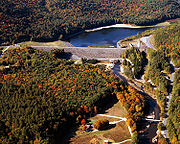
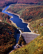
U.S. Army Corps of Engineers dam
Dam
A dam is a barrier that impounds water or underground streams. Dams generally serve the primary purpose of retaining water, while other structures such as floodgates or levees are used to manage or prevent water flow into specific land regions. Hydropower and pumped-storage hydroelectricity are...
s on the West cause the river to form Ball Mountain Lake and Townshend Lake, both of which were built for the purpose of flood control in 1961. The river between Ball Mountain Lake and Townshend Lake is used for white water boating during releases from the Ball Mountain Dam (usually occurring during one weekend in April and one weekend in September).
External links
- Friends of the West River Organization working to restore traditional whitewater releases to the West River, VT.