
Uinta Mountains
Encyclopedia
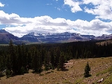
The Uinta Mountains are a high chain
of mountains in northeastern Utah
and extreme northwestern Colorado
in the United States
. A subrange of the Rocky Mountains
, they are unusual for being the highest range in the contiguous United States
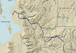
running east to west, and lie approximately 100 miles (160.9 km) east of Salt Lake City
. The peaks range in height from 11000–13500 ft (3,352.8–4,114.8 m), with the highest being Kings Peak
at 13528 ft (4,123 m), the highest point in Utah. The Mirror Lake Highway crosses the western half of the Uintas on its way to Wyoming
.
age (between about 700 million and 800 million years old) and consist primarily of quartzite
, shale
, and slate
. These rocks comprise the Uinta Mountain Group, and reach thicknesses of 4 to 7.3 km (13,123.4 to 23,950.1 ft). Most of the high peaks are in outcrops of the Uinta Mountain Group. Many of the peaks are ringed with bands of cliffs, rising to broad or flat tops.
The flanks of the east-west trending Uinta Mountains contain a sequence of Paleozoic
and Mesozoic
strata ranging from the Cambrian
Lodore Formation to the Cretaceous
Mancos Formation
, all of which have been tilted during the uplift of the mountain range.
The uplift of the range dates to the Laramide orogeny
, about 70 to 50 million years ago, when compressive forces produced high-angle reverse faults on both north and south sides of the present mountain range. The east-west orientation of the Uintas is anomalous compared to most of the ranges of the northern Rocky Mountains
; it may relate to changing stress patterns and rotation of the Colorado Plateau
The high Uintas were extensively glaciated during the last ice age
, and most of the large stream valleys on both the north and south sides of the range held long valley glaciers
.
In between the summits and ridgelines are wide, level basins, with some 500 small lakes. One of the most popular lakes is Mirror Lake
because of its good fishing and scenic views.
.jpg)
 The south and east sides of the range are largely within the Colorado River watershed including Blacks Fork
and Duchesne River
s which are tributaries of the Green River
. The Green is a major tributary of the Colorado River
and flows in a tight arc around the eastern side of the range.
The Bear
and Weber River
s, the two largest tributaries of Great Salt Lake
, rise on the northern side of the range. The Provo River
, the largest tributary to Utah Lake
, rises in the southern side of the range. Utah Lake itself drains via the Jordan River
into Great Salt Lake.
Large portions of the mountain range receive over 40 inches (101.6 cm) of precipitation annually. The high Uintas are snowcapped year-round except for late July through early September. The Uinta Mountains have more than 400 miles (643.7 km) of streams and 1,000 lakes and ponds.
ecoregion
. Nearly the entire range lies within Wasatch-Cache National Forest
(on the north and west) and Ashley National Forest
(on the south and east). The highest peaks of the range are protected as part of the High Uintas Wilderness
. The forests contain many species of trees, including lodgepole pine
, subalpine fir
, Engelmann Spruce
, Douglas-fir
, and Quaking aspen. There are also many species of grasses, shrubs, and forb
s growing in the Uinta Mountains.
, the highest boy scout camp in the United States at 10400 feet (3,169.9 m). The camp is near mile marker 33 of the Mirror Lake Highway.
The Highline Trail
traverses the entire range and is a popular backpacking trail.
Dinosaur National Monument
is located on the southeast flank of the Uinta Mountains on the border between Colorado and Utah.
Uinta Mountain Lakes Map/Info - an interactive map to help you explore the high Uinta lakes
Mountain range
A mountain range is a single, large mass consisting of a succession of mountains or narrowly spaced mountain ridges, with or without peaks, closely related in position, direction, formation, and age; a component part of a mountain system or of a mountain chain...
of mountains in northeastern Utah
Utah
Utah is a state in the Western United States. It was the 45th state to join the Union, on January 4, 1896. Approximately 80% of Utah's 2,763,885 people live along the Wasatch Front, centering on Salt Lake City. This leaves vast expanses of the state nearly uninhabited, making the population the...
and extreme northwestern Colorado
Colorado
Colorado is a U.S. state that encompasses much of the Rocky Mountains as well as the northeastern portion of the Colorado Plateau and the western edge of the Great Plains...
in the United States
United States
The United States of America is a federal constitutional republic comprising fifty states and a federal district...
. A subrange of the Rocky Mountains
Rocky Mountains
The Rocky Mountains are a major mountain range in western North America. The Rocky Mountains stretch more than from the northernmost part of British Columbia, in western Canada, to New Mexico, in the southwestern United States...
, they are unusual for being the highest range in the contiguous United States
Contiguous United States
The contiguous United States are the 48 U.S. states on the continent of North America that are south of Canada and north of Mexico, plus the District of Columbia....
running east to west, and lie approximately 100 miles (160.9 km) east of Salt Lake City
Salt Lake City, Utah
Salt Lake City is the capital and the most populous city of the U.S. state of Utah. The name of the city is often shortened to Salt Lake or SLC. With a population of 186,440 as of the 2010 Census, the city lies in the Salt Lake City metropolitan area, which has a total population of 1,124,197...
. The peaks range in height from 11000–13500 ft (3,352.8–4,114.8 m), with the highest being Kings Peak
Kings Peak
For the mountain in Idaho, see Kings Peak .Kings Peak is the highest peak in the U.S. state of Utah,with an elevation of . It lies just south of the spine of the central Uinta Mountains, in the Ashley National Forest in northeastern Utah, in north-central Duchesne County. It is also located in the...
at 13528 ft (4,123 m), the highest point in Utah. The Mirror Lake Highway crosses the western half of the Uintas on its way to Wyoming
Wyoming
Wyoming is a state in the mountain region of the Western United States. The western two thirds of the state is covered mostly with the mountain ranges and rangelands in the foothills of the Eastern Rocky Mountains, while the eastern third of the state is high elevation prairie known as the High...
.
Geology
The rocks in the core of the Uinta Mountains are of NeoproterozoicNeoproterozoic
The Neoproterozoic Era is the unit of geologic time from 1,000 to 542.0 ± 1.0 million years ago. The terminal Era of the formal Proterozoic Eon , it is further subdivided into the Tonian, Cryogenian, and Ediacaran Periods...
age (between about 700 million and 800 million years old) and consist primarily of quartzite
Quartzite
Quartzite is a hard metamorphic rock which was originally sandstone. Sandstone is converted into quartzite through heating and pressure usually related to tectonic compression within orogenic belts. Pure quartzite is usually white to gray, though quartzites often occur in various shades of pink...
, shale
Shale
Shale is a fine-grained, clastic sedimentary rock composed of mud that is a mix of flakes of clay minerals and tiny fragments of other minerals, especially quartz and calcite. The ratio of clay to other minerals is variable. Shale is characterized by breaks along thin laminae or parallel layering...
, and slate
Slate
Slate is a fine-grained, foliated, homogeneous metamorphic rock derived from an original shale-type sedimentary rock composed of clay or volcanic ash through low-grade regional metamorphism. The result is a foliated rock in which the foliation may not correspond to the original sedimentary layering...
. These rocks comprise the Uinta Mountain Group, and reach thicknesses of 4 to 7.3 km (13,123.4 to 23,950.1 ft). Most of the high peaks are in outcrops of the Uinta Mountain Group. Many of the peaks are ringed with bands of cliffs, rising to broad or flat tops.
The flanks of the east-west trending Uinta Mountains contain a sequence of Paleozoic
Paleozoic
The Paleozoic era is the earliest of three geologic eras of the Phanerozoic eon, spanning from roughly...
and Mesozoic
Mesozoic
The Mesozoic era is an interval of geological time from about 250 million years ago to about 65 million years ago. It is often referred to as the age of reptiles because reptiles, namely dinosaurs, were the dominant terrestrial and marine vertebrates of the time...
strata ranging from the Cambrian
Cambrian
The Cambrian is the first geological period of the Paleozoic Era, lasting from Mya ; it is succeeded by the Ordovician. Its subdivisions, and indeed its base, are somewhat in flux. The period was established by Adam Sedgwick, who named it after Cambria, the Latin name for Wales, where Britain's...
Lodore Formation to the Cretaceous
Cretaceous
The Cretaceous , derived from the Latin "creta" , usually abbreviated K for its German translation Kreide , is a geologic period and system from circa to million years ago. In the geologic timescale, the Cretaceous follows the Jurassic period and is followed by the Paleogene period of the...
Mancos Formation
Mancos Shale
The Mancos Shale or Mancos Group is an Upper Cretaceous geologic formation of the Western United States dominated by mudrock that accumulated in offshore and marine environments of the Cretaceous North American Inland Sea. The Mancos was deposited during the Cenomanian through Campanian ages,...
, all of which have been tilted during the uplift of the mountain range.
The uplift of the range dates to the Laramide orogeny
Laramide orogeny
The Laramide orogeny was a period of mountain building in western North America, which started in the Late Cretaceous, 70 to 80 million years ago, and ended 35 to 55 million years ago. The exact duration and ages of beginning and end of the orogeny are in dispute, as is the cause. The Laramide...
, about 70 to 50 million years ago, when compressive forces produced high-angle reverse faults on both north and south sides of the present mountain range. The east-west orientation of the Uintas is anomalous compared to most of the ranges of the northern Rocky Mountains
Rocky Mountains
The Rocky Mountains are a major mountain range in western North America. The Rocky Mountains stretch more than from the northernmost part of British Columbia, in western Canada, to New Mexico, in the southwestern United States...
; it may relate to changing stress patterns and rotation of the Colorado Plateau
Colorado Plateau
The Colorado Plateau, also called the Colorado Plateau Province, is a physiographic region of the Intermontane Plateaus, roughly centered on the Four Corners region of the southwestern United States. The province covers an area of 337,000 km2 within western Colorado, northwestern New Mexico,...
The high Uintas were extensively glaciated during the last ice age
Ice age
An ice age or, more precisely, glacial age, is a generic geological period of long-term reduction in the temperature of the Earth's surface and atmosphere, resulting in the presence or expansion of continental ice sheets, polar ice sheets and alpine glaciers...
, and most of the large stream valleys on both the north and south sides of the range held long valley glaciers
Glacier
A glacier is a large persistent body of ice that forms where the accumulation of snow exceeds its ablation over many years, often centuries. At least 0.1 km² in area and 50 m thick, but often much larger, a glacier slowly deforms and flows due to stresses induced by its weight...
.
In between the summits and ridgelines are wide, level basins, with some 500 small lakes. One of the most popular lakes is Mirror Lake
Mirror Lake (Utah)
Mirror Lake is a lake in the high Uinta Mountains in Utah. It is a popular fishing and recreation spot. The lake has a Forest Service campground, picnic facilities, and a boat ramp for non-motorized watercraft...
because of its good fishing and scenic views.
Hydrology
Blacks Fork
Blacks Fork is a tributary of the Green River in Utah and Wyoming. The river rises on the northern side of the Uinta Mountains as the combination of three streams draining the area around Tokewanna Peak near the Utah-Wyoming border...
and Duchesne River
Duchesne River
The Duchesne River, located in Uintah Basin region of Utah in the western United States, is a tributary of the Green River. The watershed of the river covers the Northeastern corner of Utah...
s which are tributaries of the Green River
Green River (Utah)
The Green River, located in the western United States, is the chief tributary of the Colorado River. The watershed of the river, known as the Green River Basin, covers parts of Wyoming, Utah, and Colorado. The Green River is long, beginning in the Wind River Mountains of Wyoming and flowing...
. The Green is a major tributary of the Colorado River
Colorado River
The Colorado River , is a river in the Southwestern United States and northwestern Mexico, approximately long, draining a part of the arid regions on the western slope of the Rocky Mountains. The watershed of the Colorado River covers in parts of seven U.S. states and two Mexican states...
and flows in a tight arc around the eastern side of the range.
The Bear
Bear River (Utah)
The Bear River is a river, approximately long, in southwestern Wyoming, southeastern Idaho, and northern Utah, in the United States. The largest tributary of the Great Salt Lake, it drains a mountainous area and farming valleys northeast of the lake and southeast of the Snake River Plain...
and Weber River
Weber River
The Weber River is a c. long river of northern Utah, USA. It begins in the northwest of the Uinta Mountains and empties into the Great Salt Lake. The Weber River was named for American fur trapper John Henry Weber.-Weber River:...
s, the two largest tributaries of Great Salt Lake
Great Salt Lake
The Great Salt Lake, located in the northern part of the U.S. state of Utah, is the largest salt water lake in the western hemisphere, the fourth-largest terminal lake in the world. In an average year the lake covers an area of around , but the lake's size fluctuates substantially due to its...
, rise on the northern side of the range. The Provo River
Provo River (Utah)
The Provo River is located in Utah County and Wasatch County, Utah, in the United States. It rises in the Uinta Mountains at Washington Lake and flows about southwest to Utah Lake at the city of Provo, Utah.-Course:...
, the largest tributary to Utah Lake
Utah Lake
Utah Lake is a freshwater lake in the U.S. state of Utah. On the western side of Utah Valley, the lake is overlooked by Mount Timpanogos and Mount Nebo. The lake's only river outlet, the Jordan River, is a tributary of the Great Salt Lake and is highly regulated with pumps. Evaporation accounts...
, rises in the southern side of the range. Utah Lake itself drains via the Jordan River
Jordan River (Utah)
The Jordan River in the U.S. state of Utah is a river about long. Regulated by pumps at its headwaters at Utah Lake, it flows northward through the Salt Lake Valley and empties into the Great Salt Lake. Four of Utah's five largest cities—Salt Lake City, West Valley City, West Jordan and...
into Great Salt Lake.
Large portions of the mountain range receive over 40 inches (101.6 cm) of precipitation annually. The high Uintas are snowcapped year-round except for late July through early September. The Uinta Mountains have more than 400 miles (643.7 km) of streams and 1,000 lakes and ponds.
Ecology
The Uinta Mountains are part of the Wasatch and Uinta montane forestsWasatch and Uinta montane forests
The Wasatch and Uinta montane forest is a temperate coniferous forest ecoregion of the United States.-Setting:This ecoregion is located almost entirely within the state of Utah, with a very small portion stretching north just into southwestern Wyoming...
ecoregion
Ecoregion
An ecoregion , sometimes called a bioregion, is an ecologically and geographically defined area that is smaller than an ecozone and larger than an ecosystem. Ecoregions cover relatively large areas of land or water, and contain characteristic, geographically distinct assemblages of natural...
. Nearly the entire range lies within Wasatch-Cache National Forest
Wasatch-Cache National Forest
Uinta-Wasatch-Cache National Forest is a United States National Forest located primarily in northern Utah , with smaller parts extending into southeastern Idaho and southwestern Wyoming . The name is from the Ute word Wasatch for a low place in high mountains, and the French word Cache meaning to...
(on the north and west) and Ashley National Forest
Ashley National Forest
Ashley National Forest is a national forest located in northeastern Utah and southwestern Wyoming. Within the Forest’s bounds are of vast forests, lakes, and mountains, with elevations ranging from . The Forest covers portions of Utah; Duchesne; Uintah; Daggett; and Summit counties in Utah and...
(on the south and east). The highest peaks of the range are protected as part of the High Uintas Wilderness
High Uintas Wilderness
The High Uintas Wilderness is a wilderness area located in northeastern Utah, United States. The wilderness covers the Uinta Mountains, encompassing parts of Duchesne and Summit counties. Designated as a wilderness in 1984, the area is located within parts of Ashley National Forest and Wasatch...
. The forests contain many species of trees, including lodgepole pine
Lodgepole Pine
Lodgepole Pine, Pinus contorta, also known as Shore Pine, is a common tree in western North America. Like all pines, it is evergreen.-Subspecies:...
, subalpine fir
Subalpine Fir
The Subalpine Fir or Rocky Mountain Fir is a western North American fir, native to the mountains of Yukon, British Columbia and western Alberta in Canada; southeastern Alaska, Washington, Oregon, Idaho, western Montana, Wyoming, Utah, Colorado, New Mexico, Arizona, northeastern Nevada, and the...
, Engelmann Spruce
Engelmann Spruce
Picea engelmannii is a species of spruce native to western North America, from central British Columbia and southwest Alberta, southwest to northern California and southeast to Arizona and New Mexico; there are also two isolated populations in northern Mexico...
, Douglas-fir
Douglas-fir
Douglas-fir is one of the English common names for evergreen coniferous trees of the genus Pseudotsuga in the family Pinaceae. Other common names include Douglas tree, and Oregon pine. There are five species, two in western North America, one in Mexico, and two in eastern Asia...
, and Quaking aspen. There are also many species of grasses, shrubs, and forb
Forb
A forb is a herbaceous flowering plant that is not a graminoid . The term is used in biology and in vegetation ecology, especially in relation to grasslands and understory.-Etymology:...
s growing in the Uinta Mountains.
Points of interest
The Uintas is home to Camp SteinerCamp Steiner
The Great Salt Lake Council is a local council of the Boy Scouts of America and serves the Utah counties of Salt Lake, Tooele, Summit and much of Davis County.-Organization:The council is divided into these districts:* * * * *...
, the highest boy scout camp in the United States at 10400 feet (3,169.9 m). The camp is near mile marker 33 of the Mirror Lake Highway.
The Highline Trail
Highline Trail, Utah
The Highline Trail is a trail in the Uinta Mountain Range of Utah that crosses the range from the east to the west. The trail, sometimes called the Uinta Highline Trail, is long and follows the crest of the Uintas. Much of the trail is located in the High Uintas Wilderness...
traverses the entire range and is a popular backpacking trail.
Dinosaur National Monument
Dinosaur National Monument
Dinosaur National Monument is a National Monument located on the southeast flank of the Uinta Mountains on the border between Colorado and Utah at the confluence of the Green and Yampa Rivers. Although most of the monument area is in Moffat County, Colorado, the Dinosaur Quarry is located in Utah...
is located on the southeast flank of the Uinta Mountains on the border between Colorado and Utah.
See also
- Features of the Uinta Mountains
- High Uintas WildernessHigh Uintas WildernessThe High Uintas Wilderness is a wilderness area located in northeastern Utah, United States. The wilderness covers the Uinta Mountains, encompassing parts of Duchesne and Summit counties. Designated as a wilderness in 1984, the area is located within parts of Ashley National Forest and Wasatch...
External links
Uinta Mountain Lakes Map/Info - an interactive map to help you explore the high Uinta lakes