
.gif)
Sandy River (Oregon)
Encyclopedia
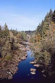
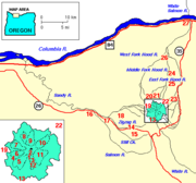
The Sandy River is a 56 miles (90.1 km) tributary of the Columbia River
in northwestern Oregon
in the United States
. Measured by a United States Geological Survey
(USGS) gauge downstream of the Sandy's confluence with the Bull Run River
, 18.4 miles (29.6 km) from the mouth, the river's average discharge
is 2300 ft3/s. The maximum daily recorded flow is 84400 ft3/s, and the minimum is 45 ft3/s. The Sandy joins the Columbia about 14 miles (22.5 km) upstream of Portland
.
on the southwest flanks of Mount Hood
in the Cascade Range
, the Sandy River flows generally west and then north for 56 miles (90.1 km) through Clackamas County
and Multnomah County
to the Columbia River
at Troutdale
. In its first 12 miles (19.3 km), the Sandy River flows across Old Maid Flat, north of Zigzag Mountain
in the Mount Hood Wilderness
of the Mount Hood National Forest
. In this initial stretch near the headwaters, it receives Rushing Water Creek from the left, Muddy Fork
from the right, then Lost Creek and Horseshoe Creek from the left, and crosses under Lolo Pass
Road just before receiving Clear Creek from the right. At about 41 miles (66 km) from the mouth, the Zigzag River
enters from the left near the unincorporated community of Zigzag
. From here the river runs roughly parallel to U.S. Route 26
, which is on its left for about the next 20 miles (32.2 km). Just below Zigzag, the Sandy River passes the unincorporated community of Wemme
on the left.
At about 39 miles (62.8 km) from the mouth, the river receives Hackett Creek from the right, passes the unincorporated community of Brightwood
shortly thereafter, and receives North Boulder Creek from the right. Barlow Trail County Park and remnants of the Barlow Road
lie to the right along this stretch of the river. Between 38 miles (61.2 km) and 37 miles (59.5 km) from the mouth, the Salmon River
enters from the left. Roughly 4 miles (6.4 km) later, Wildcat Creek enters from the left and then Alder Creek and Whiskey Creek, also from the left. The river passes the Marmot gauging station operated by the United States Geological Survey
(USGS) in cooperation with Portland General Electric
at river mile
(RM) 29.8 (river kilometer (RK) 48.0). The unincorporated community of Marmot
lies to the right of the river on a ridge—the Devil's Backbone—separating the Sandy River from the Little Sandy River
to the north.
About 4 miles (6.4 km) below the Marmot gauge, the river receives Badger Creek from the left. It passes under Ten Eyck Road about 24 miles (38.6 km) from the mouth, flowing by the city of Sandy
on the left, shortly thereafter and receiving Cedar Creek, home of the Sandy Fish Hatchery, from the left. At about 22 miles (35.4 km) from the mouth, the river turns away from Highway 26 and flows generally north-northwest for the rest of its course. About 3 miles (4.8 km) further downstream, the river passes Dodge Park on the right, receives the Bull Run River
from the right and passes a second USGS gauge at RM 18.4 (RK 29.6).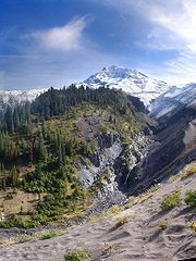 Shortly thereafter, Walker Creek enters from the right. Between 17 miles (27.4 km) and 16 miles (25.7 km) from the mouth, the Sandy River enters Multnomah County, curves back into Clackamas County, and re-enters Multnomah County. About 1 miles (1.6 km) further downstream, Bear Creek enters from the left, and the river flows around Indian John Island.
Soon Trout Creek, Gordon Creek, and Buck Creek all enter from the right as the river winds through Oxbow Regional Park
between 14 miles (22.5 km) and 11 miles (17.7 km) from the mouth. Passing Camp Collins about 1 miles (1.6 km) later, the river receives Big Creek from the right. Dabney State Recreation Area
is on the right about 4 miles (6.4 km) later. Lewis and Clark State Recreation Site
is on the right and Troutdale on the left at about 3 miles (4.8 km) from the mouth, where Beaver Creek enters from the left. Shortly thereafter, the river passes under Interstate 84
and flows by Portland-Troutdale Airport, which is on the left about 2 miles (3.2 km) from the mouth. The Sandy River then joins the Columbia River about 120 miles (193.1 km) from where the larger river enters the Pacific Ocean. The confluence is about 14 miles (22.5 km) east of Portland, near the lower end of the Columbia River Gorge
.
 Archeological evidence suggests that Native Americans
lived along the lower Columbia River as early as 10,000 years ago. The area near what later became The Dalles
, on the Columbia east of the mouth of the Sandy River, eventually became an important trading center. The Indians established villages on floodplains and traveled seasonally to gather huckleberries and other food on upland meadows, to fish for salmon, and to hunt elk and deer. Although no direct evidence exists that these lower-Columbia Indians traveled up the Sandy, it is likely that they did. Traces of these people include petroglyph
s carved into the rocks of the Columbia River Gorge. More recently, within the past few thousand years, Indians created trails across the Cascade Range around Mount Hood. The trail network linked the trading center at Wascopam, near The Dalles, to settlements in the Willamette Valley
. One popular trail crossed over Lolo Pass and another, which later became the Barlow Road, met the Lolo Pass trail roughly where the Zigzag and Salmon rivers enter the Sandy. Indians from villages along the Columbia, Clackamas
, and other rivers also traveled by water to the lower Sandy River area to fish for salmon and to gather berries, nuts and roots.
In 1792 William Robert Broughton
of the Vancouver Expedition
explored the lower Columbia River. He named the Sandy River "Baring River", but noted the existence of a large sand bank that nearly blocked the Columbia River at the mouth of the Sandy River. In 1805 and again in 1806, members of the Lewis and Clark Expedition
explored the lower stretches of the Sandy River as they traveled down the Columbia to the Pacific Ocean. Mount Hood
, at the river's headwaters, had erupted a few years earlier, causing loose sediment to collect at the river's mouth. On November 3, 1805, William Clark wrote: "I arrived at the entrance of a river which appeared to Scatter over a Sand bar, the bottom of which I could See quite across and did not appear to be 4 Inches deep in any part; I attempted to wade this Stream and to my astonishment found the bottom a quick Sand, and impassable... ".
One of the first documented visits by European-Americans to the upper Sandy River basin occurred in 1838, when Daniel Lee, the nephew of missionary Jason Lee
, used the Indian trail over Lolo Pass to drive cattle from a Methodist mission in the Willamette Valley to a mission in Wascopam. Other pioneers later used the trail to drive livestock over the mountains. The first wagons came over the Cascades in 1840, and in 1843 the great east-west migration of settlers to the Oregon Territory
began. The Barlow Road, along the Indian trail leading west from the Lolo Trail, opened in 1846 and became popular with new settlers. A branch of this road followed the Devil's Backbone between the Sandy and the Little Sandy watersheds.
 Until October 2007, the river was dammed and the flow rate regulated. The Bull Run Hydroelectric Project
diverted water from the Sandy River at the Marmot Dam to the Little Sandy River
at the Little Sandy Dam. Water was diverted from the Little Sandy River to Roslyn Lake through a wood box flume
. The artificial lake supplied the 22-megawatt Bull Run hydroelectric powerhouse and emptied into the Bull Run River
.
On July 24, 2007, Marmot Dam was demolished by engineers using 650 pounds (294.8 kg) of explosives. It was followed by the Little Sandy Dam in 2008, and Roslyn Lake ceased to exist. The decommissioning restored the Little Sandy River to steelhead and salmon
runs for the first time in a hundred years. Marmot Dam had always contained a fish ladder. Portland General Electric
, the dams' owner, donated 1500 acres (6.1 km²) of land near the dams to a nature reserve. The final phase of the Marmot Dam removal was completed on October 19, 2007, when the temporary dam was demolished and the river started to flow freely for the first time since 1912.
(boat ramp), Dabney State Recreation Area
(boat ramp + parking fees), Oxbow Regional Park
(boat ramp + parking fees) and Dodge Park. During the summer heat the river is filled with people floating on rafts and tubes from Oxbow park to the downstream Lewis and Clark State Park. Upstream there are many opportunities for whitewater rafting and kayaking.
Columbia River
The Columbia River is the largest river in the Pacific Northwest region of North America. The river rises in the Rocky Mountains of British Columbia, Canada, flows northwest and then south into the U.S. state of Washington, then turns west to form most of the border between Washington and the state...
in northwestern Oregon
Oregon
Oregon is a state in the Pacific Northwest region of the United States. It is located on the Pacific coast, with Washington to the north, California to the south, Nevada on the southeast and Idaho to the east. The Columbia and Snake rivers delineate much of Oregon's northern and eastern...
in the United States
United States
The United States of America is a federal constitutional republic comprising fifty states and a federal district...
. Measured by a United States Geological Survey
United States Geological Survey
The United States Geological Survey is a scientific agency of the United States government. The scientists of the USGS study the landscape of the United States, its natural resources, and the natural hazards that threaten it. The organization has four major science disciplines, concerning biology,...
(USGS) gauge downstream of the Sandy's confluence with the Bull Run River
Bull Run River (Oregon)
The Bull Run River is a tributary of the Sandy River in the U.S. state of Oregon. Beginning at the lower end of Bull Run Lake in the Cascade Range, it flows generally west through the Bull Run Watershed Management Unit , a restricted area meant to protect the river and its tributaries from...
, 18.4 miles (29.6 km) from the mouth, the river's average discharge
Discharge (hydrology)
In hydrology, discharge is the volume rate of water flow, including any suspended solids , dissolved chemical species and/or biologic material , which is transported through a given cross-sectional area...
is 2300 ft3/s. The maximum daily recorded flow is 84400 ft3/s, and the minimum is 45 ft3/s. The Sandy joins the Columbia about 14 miles (22.5 km) upstream of Portland
Portland, Oregon
Portland is a city located in the Pacific Northwest, near the confluence of the Willamette and Columbia rivers in the U.S. state of Oregon. As of the 2010 Census, it had a population of 583,776, making it the 29th most populous city in the United States...
.
Course
Issuing from Reid GlacierReid Glacier (Oregon)
Reid Glacier is an alpine glacier located on the west slope of Mount Hood in the U.S. state of Oregon. It ranges in elevation from about 6,000 to 9,800 ft . The glacier is the source of the Sandy River. The upper extent of the glacier is known for extensive crevasses.The glacier is a...
on the southwest flanks of Mount Hood
Mount Hood
Mount Hood, called Wy'east by the Multnomah tribe, is a stratovolcano in the Cascade Volcanic Arc of northern Oregon. It was formed by a subduction zone and rests in the Pacific Northwest region of the United States...
in the Cascade Range
Cascade Range
The Cascade Range is a major mountain range of western North America, extending from southern British Columbia through Washington and Oregon to Northern California. It includes both non-volcanic mountains, such as the North Cascades, and the notable volcanoes known as the High Cascades...
, the Sandy River flows generally west and then north for 56 miles (90.1 km) through Clackamas County
Clackamas County, Oregon
Clackamas County is a county located in the U.S. state of Oregon. The county was named after the Native Americans living in the area, the Clackamas Indians, who were part of the Chinookan people. As of 2010, the population was 375,992...
and Multnomah County
Multnomah County, Oregon
Multnomah County is one of 36 counties in the U.S. state of Oregon. Though smallest in area, it is the most populous as its county seat, Portland, is the state's largest city...
to the Columbia River
Columbia River
The Columbia River is the largest river in the Pacific Northwest region of North America. The river rises in the Rocky Mountains of British Columbia, Canada, flows northwest and then south into the U.S. state of Washington, then turns west to form most of the border between Washington and the state...
at Troutdale
Troutdale, Oregon
Troutdale is a city in Multnomah County, Oregon, north of Gresham and east of Wood Village. As of the 2010 census, the city population was 15,962....
. In its first 12 miles (19.3 km), the Sandy River flows across Old Maid Flat, north of Zigzag Mountain
Zigzag Mountain
Zigzag Mountain is a volcanic mountain in Clackamas County in the U.S. state of Oregon.It is located west-southwest of Mount Hood, northwest of Government Camp, east of Zigzag, and north of the Zigzag River. Because of its proximity to Mount Hood, it is considered a foothill.The highest peak is ...
in the Mount Hood Wilderness
Mount Hood Wilderness
The Mount Hood Wilderness is a protected wilderness area inside the Mount Hood National Forest which is located in the U.S. state of Oregon. The area, covering , includes the peak of Mount Hood and its upper slopes, and ranges from temperate rain forests at the lower elevations, to glaciers and...
of the Mount Hood National Forest
Mount Hood National Forest
The Mount Hood National Forest is located east of the city of Portland, Oregon, and the northern Willamette River valley. The Forest extends south from the Columbia River Gorge across more than of forested mountains, lakes and streams to the Olallie Scenic Area, a high lake basin under the slopes...
. In this initial stretch near the headwaters, it receives Rushing Water Creek from the left, Muddy Fork
Muddy Fork (Oregon)
Muddy Fork is a tributary, about long, of the Sandy River in the U.S. state of Oregon. Arising at the base of Sandy Glacier on the west slope of Mount Hood, it flows west through the Mount Hood Wilderness in the Mount Hood National Forest. It joins the Sandy River in Old Maid Flat, about ...
from the right, then Lost Creek and Horseshoe Creek from the left, and crosses under Lolo Pass
Lolo Pass (Oregon)
Lolo Pass is a mountain pass northwest of Mount Hood and northeast of Zigzag, Oregon, on the Clackamas–Hood River county line. It divides the Sandy River watershed on the southwest from the Hood River watershed on the northeast....
Road just before receiving Clear Creek from the right. At about 41 miles (66 km) from the mouth, the Zigzag River
Zigzag River
The Zigzag River is a tributary, about long, of the Sandy River in the U.S. state of Oregon. The Zigzag and one of its major tributaries, the Little Zigzag River, drain the Zigzag Glacier on Mount Hood, a high volcanic peak in the Cascade Range. Their waters flow westward to meet the Sandy River...
enters from the left near the unincorporated community of Zigzag
Zigzag, Oregon
Zigzag is an unincorporated community in Clackamas County, Oregon, United States. It is located within the Mount Hood Corridor, between Rhododendron and Welches on U.S. Route 26...
. From here the river runs roughly parallel to U.S. Route 26
U.S. Route 26 in Oregon
In the U.S. state of Oregon, U.S. Route 26 is a major cross-state state highway, connecting U.S. Route 101 on the Oregon Coast near Seaside with the Idaho state line east of Nyssa. Local highway names include the Sunset Highway No. 47, Mount Hood Highway No. 26, and John Day Highway No...
, which is on its left for about the next 20 miles (32.2 km). Just below Zigzag, the Sandy River passes the unincorporated community of Wemme
Wemme, Oregon
Wemme is an unincorporated community in Clackamas County, Oregon, United States. It is located within the Mount Hood Corridor, between Welches and Brightwood along U.S. Route 26. It is one of the communities that make up the Villages at Mount Hood....
on the left.
At about 39 miles (62.8 km) from the mouth, the river receives Hackett Creek from the right, passes the unincorporated community of Brightwood
Brightwood, Oregon
Brightwood is an unincorporated community within the Mount Hood Corridor in Clackamas County, Oregon, United States. It is located between Wemme and Sandy just off of U.S. Route 26 at an elevation of 355 meters. It is one of the communities that make up the Villages at Mount Hood.A post office...
shortly thereafter, and receives North Boulder Creek from the right. Barlow Trail County Park and remnants of the Barlow Road
Barlow Road
The Barlow Road is a historic road in what is now the U.S. state of Oregon. It was built in 1846 by Sam Barlow and Philip Foster, with authorization of the Provisional Legislature of Oregon, and served as the last overland segment of the Oregon Trail...
lie to the right along this stretch of the river. Between 38 miles (61.2 km) and 37 miles (59.5 km) from the mouth, the Salmon River
Salmon River (Clackamas County, Oregon)
The Salmon River is a 33.9 mile river in Oregon's Cascade Range and drains a portion of southwestern Mount Hood.The entire length of the river is protected National Wild and Scenic River, the only such river in the contiguous 48 states....
enters from the left. Roughly 4 miles (6.4 km) later, Wildcat Creek enters from the left and then Alder Creek and Whiskey Creek, also from the left. The river passes the Marmot gauging station operated by the United States Geological Survey
United States Geological Survey
The United States Geological Survey is a scientific agency of the United States government. The scientists of the USGS study the landscape of the United States, its natural resources, and the natural hazards that threaten it. The organization has four major science disciplines, concerning biology,...
(USGS) in cooperation with Portland General Electric
Portland General Electric
Portland General Electric is an electrical utility based in Portland in the U.S. state of Oregon. It distributes electricity to customers in parts of Multnomah, Clackamas, Marion, Yamhill, Washington, and Polk counties - half of the inhabitants of Oregon...
at river mile
River mile
In the United States, a River mile is a measure of distance in miles along a river from its mouth. River mile numbers begin at zero and increase further upstream. The corresponding metric unit using kilometers is the River kilometer...
(RM) 29.8 (river kilometer (RK) 48.0). The unincorporated community of Marmot
Marmot, Oregon
Marmot is an unincorporated community in Clackamas County, Oregon, United States located in the Mount Hood Corridor. It is within the boundaries of the Villages at Mount Hood, on a ridge known at Devil's Backbone, which lies between the Sandy and Little Sandy rivers, along the historic Barlow Road...
lies to the right of the river on a ridge—the Devil's Backbone—separating the Sandy River from the Little Sandy River
Little Sandy River (Oregon)
The Little Sandy River is a tributary, roughly long, of the Bull Run River in the U.S. state of Oregon. Forming west of Mount Hood in the Mount Hood National Forest, it flows generally west, roughly parallel to the Sandy River to the south...
to the north.
About 4 miles (6.4 km) below the Marmot gauge, the river receives Badger Creek from the left. It passes under Ten Eyck Road about 24 miles (38.6 km) from the mouth, flowing by the city of Sandy
Sandy, Oregon
Sandy is a city located in Clackamas County, Oregon, United States, and named after the nearby Sandy River. As of the 2000 census, the city had a total population of 5,385, however the 2006 estimate shows 7,070 people....
on the left, shortly thereafter and receiving Cedar Creek, home of the Sandy Fish Hatchery, from the left. At about 22 miles (35.4 km) from the mouth, the river turns away from Highway 26 and flows generally north-northwest for the rest of its course. About 3 miles (4.8 km) further downstream, the river passes Dodge Park on the right, receives the Bull Run River
Bull Run River (Oregon)
The Bull Run River is a tributary of the Sandy River in the U.S. state of Oregon. Beginning at the lower end of Bull Run Lake in the Cascade Range, it flows generally west through the Bull Run Watershed Management Unit , a restricted area meant to protect the river and its tributaries from...
from the right and passes a second USGS gauge at RM 18.4 (RK 29.6).
Soon Trout Creek, Gordon Creek, and Buck Creek all enter from the right as the river winds through Oxbow Regional Park
Oxbow Regional Park
Oxbow Regional Park is a natural area park located ten miles southeast of Troutdale along the Sandy River in the U.S. state of Oregon. Owned and operated by Metro regional government, it hosts a yearly festival celebrating salmon.-Recreation:...
between 14 miles (22.5 km) and 11 miles (17.7 km) from the mouth. Passing Camp Collins about 1 miles (1.6 km) later, the river receives Big Creek from the right. Dabney State Recreation Area
Dabney State Recreation Area
Dabney State Recreation Area is a park on the Sandy River in the U.S. state of Oregon. Located in Multnomah County outside the city of Troutdale, the park offers swimming, boating, disc golf, and other activities....
is on the right about 4 miles (6.4 km) later. Lewis and Clark State Recreation Site
Lewis and Clark State Recreation Site
Lewis and Clark State Recreation Site is a state park in eastern Multnomah County, Oregon, near Troutdale and Corbett, and is administered by the Oregon Parks and Recreation Department. It is located on the Sandy River, near its confluence with the Columbia River. Broughton's Bluff marks the...
is on the right and Troutdale on the left at about 3 miles (4.8 km) from the mouth, where Beaver Creek enters from the left. Shortly thereafter, the river passes under Interstate 84
Interstate 84 (west)
Interstate 84 is an Interstate Highway in the Western United States that runs from Portland, Oregon, to a junction with Interstate 80 near Echo, Utah. The highway originally served as a fork of I-80 to serve the Pacific Northwest, and was originally numbered Interstate 80N.The highway serves and...
and flows by Portland-Troutdale Airport, which is on the left about 2 miles (3.2 km) from the mouth. The Sandy River then joins the Columbia River about 120 miles (193.1 km) from where the larger river enters the Pacific Ocean. The confluence is about 14 miles (22.5 km) east of Portland, near the lower end of the Columbia River Gorge
Columbia River Gorge
The Columbia River Gorge is a canyon of the Columbia River in the Pacific Northwest of the United States. Up to deep, the canyon stretches for over as the river winds westward through the Cascade Range forming the boundary between the State of Washington to the north and Oregon to the south...
.
History
Native Americans in the United States
Native Americans in the United States are the indigenous peoples in North America within the boundaries of the present-day continental United States, parts of Alaska, and the island state of Hawaii. They are composed of numerous, distinct tribes, states, and ethnic groups, many of which survive as...
lived along the lower Columbia River as early as 10,000 years ago. The area near what later became The Dalles
The Dalles, Oregon
The Dalles is the largest city and county seat of Wasco County, Oregon, United States. The name of the city comes from the French word dalle The Dalles is the largest city and county seat of Wasco County, Oregon, United States. The name of the city comes from the French word dalle The Dalles is...
, on the Columbia east of the mouth of the Sandy River, eventually became an important trading center. The Indians established villages on floodplains and traveled seasonally to gather huckleberries and other food on upland meadows, to fish for salmon, and to hunt elk and deer. Although no direct evidence exists that these lower-Columbia Indians traveled up the Sandy, it is likely that they did. Traces of these people include petroglyph
Petroglyph
Petroglyphs are pictogram and logogram images created by removing part of a rock surface by incising, picking, carving, and abrading. Outside North America, scholars often use terms such as "carving", "engraving", or other descriptions of the technique to refer to such images...
s carved into the rocks of the Columbia River Gorge. More recently, within the past few thousand years, Indians created trails across the Cascade Range around Mount Hood. The trail network linked the trading center at Wascopam, near The Dalles, to settlements in the Willamette Valley
Willamette Valley
The Willamette Valley is the most populated region in the state of Oregon of the United States. Located in the state's northwest, the region is surrounded by tall mountain ranges to the east, west and south and the valley's floor is broad, flat and fertile because of Ice Age conditions...
. One popular trail crossed over Lolo Pass and another, which later became the Barlow Road, met the Lolo Pass trail roughly where the Zigzag and Salmon rivers enter the Sandy. Indians from villages along the Columbia, Clackamas
Clackamas River
The Clackamas River is an approximately tributary of the Willamette River in northwestern Oregon, in the United States. As it drains an area of about , the Clackamas passes through mostly forested and rugged mountainous terrain in its upper reaches, and passes through agricultural and urban areas...
, and other rivers also traveled by water to the lower Sandy River area to fish for salmon and to gather berries, nuts and roots.
In 1792 William Robert Broughton
William Robert Broughton
William Robert Broughton was a British naval officer in the late 18th century. As a Lieutenant in the Royal Navy, he commanded HMS Chatham as part of the Vancouver Expedition, a voyage of exploration through the Pacific Ocean led by Captain George Vancouver in the early 1790s.-With Vancouver:In...
of the Vancouver Expedition
Vancouver Expedition
The Vancouver Expedition was a four-and-a-half-year voyage of exploration and diplomacy, commanded by Captain George Vancouver. The expedition circumnavigated the globe, touched five continents and changed the course of history for the indigenous nations and several European empires and their...
explored the lower Columbia River. He named the Sandy River "Baring River", but noted the existence of a large sand bank that nearly blocked the Columbia River at the mouth of the Sandy River. In 1805 and again in 1806, members of the Lewis and Clark Expedition
Lewis and Clark Expedition
The Lewis and Clark Expedition, or ″Corps of Discovery Expedition" was the first transcontinental expedition to the Pacific Coast by the United States. Commissioned by President Thomas Jefferson and led by two Virginia-born veterans of Indian wars in the Ohio Valley, Meriwether Lewis and William...
explored the lower stretches of the Sandy River as they traveled down the Columbia to the Pacific Ocean. Mount Hood
Mount Hood
Mount Hood, called Wy'east by the Multnomah tribe, is a stratovolcano in the Cascade Volcanic Arc of northern Oregon. It was formed by a subduction zone and rests in the Pacific Northwest region of the United States...
, at the river's headwaters, had erupted a few years earlier, causing loose sediment to collect at the river's mouth. On November 3, 1805, William Clark wrote: "I arrived at the entrance of a river which appeared to Scatter over a Sand bar, the bottom of which I could See quite across and did not appear to be 4 Inches deep in any part; I attempted to wade this Stream and to my astonishment found the bottom a quick Sand, and impassable... ".
One of the first documented visits by European-Americans to the upper Sandy River basin occurred in 1838, when Daniel Lee, the nephew of missionary Jason Lee
Jason Lee (missionary)
Jason Lee , an American missionary and pioneer, was born on a farm near Stanstead, Quebec. He was the first of the Oregon missionaries and helped establish the early foundation of a provisional government in the Oregon Country....
, used the Indian trail over Lolo Pass to drive cattle from a Methodist mission in the Willamette Valley to a mission in Wascopam. Other pioneers later used the trail to drive livestock over the mountains. The first wagons came over the Cascades in 1840, and in 1843 the great east-west migration of settlers to the Oregon Territory
Oregon Territory
The Territory of Oregon was an organized incorporated territory of the United States that existed from August 14, 1848, until February 14, 1859, when the southwestern portion of the territory was admitted to the Union as the State of Oregon. Originally claimed by several countries , the region was...
began. The Barlow Road, along the Indian trail leading west from the Lolo Trail, opened in 1846 and became popular with new settlers. A branch of this road followed the Devil's Backbone between the Sandy and the Little Sandy watersheds.
Hydroelectric decommissioning
Bull Run Hydroelectric Project
The Bull Run Hydroelectric Project was a Portland General Electric development in the Sandy River basin in the U.S. state of Oregon. Originally built between 1908 and 1912 near the town of Bull Run, it supplied hydroelectric power for the Portland area for nearly a century, until it was removed in...
diverted water from the Sandy River at the Marmot Dam to the Little Sandy River
Little Sandy River (Oregon)
The Little Sandy River is a tributary, roughly long, of the Bull Run River in the U.S. state of Oregon. Forming west of Mount Hood in the Mount Hood National Forest, it flows generally west, roughly parallel to the Sandy River to the south...
at the Little Sandy Dam. Water was diverted from the Little Sandy River to Roslyn Lake through a wood box flume
Flume
A flume is an open artificial water channel, in the form of a gravity chute, that leads water from a diversion dam or weir completely aside a natural flow. Often, the flume is an elevated box structure that follows the natural contours of the land. These have been extensively used in hydraulic...
. The artificial lake supplied the 22-megawatt Bull Run hydroelectric powerhouse and emptied into the Bull Run River
Bull Run River (Oregon)
The Bull Run River is a tributary of the Sandy River in the U.S. state of Oregon. Beginning at the lower end of Bull Run Lake in the Cascade Range, it flows generally west through the Bull Run Watershed Management Unit , a restricted area meant to protect the river and its tributaries from...
.
On July 24, 2007, Marmot Dam was demolished by engineers using 650 pounds (294.8 kg) of explosives. It was followed by the Little Sandy Dam in 2008, and Roslyn Lake ceased to exist. The decommissioning restored the Little Sandy River to steelhead and salmon
Salmon
Salmon is the common name for several species of fish in the family Salmonidae. Several other fish in the same family are called trout; the difference is often said to be that salmon migrate and trout are resident, but this distinction does not strictly hold true...
runs for the first time in a hundred years. Marmot Dam had always contained a fish ladder. Portland General Electric
Portland General Electric
Portland General Electric is an electrical utility based in Portland in the U.S. state of Oregon. It distributes electricity to customers in parts of Multnomah, Clackamas, Marion, Yamhill, Washington, and Polk counties - half of the inhabitants of Oregon...
, the dams' owner, donated 1500 acres (6.1 km²) of land near the dams to a nature reserve. The final phase of the Marmot Dam removal was completed on October 19, 2007, when the temporary dam was demolished and the river started to flow freely for the first time since 1912.
Recreation
The river is popular among boaters and inner tube floaters as it is one of the few declared navigable rivers in Oregon. Because of this, public use is permitted from the line of high water mark and below. The most notable parks on the Sandy River (going upstream) are Glenn Otto Park, Lewis and Clark State Recreation SiteLewis and Clark State Recreation Site
Lewis and Clark State Recreation Site is a state park in eastern Multnomah County, Oregon, near Troutdale and Corbett, and is administered by the Oregon Parks and Recreation Department. It is located on the Sandy River, near its confluence with the Columbia River. Broughton's Bluff marks the...
(boat ramp), Dabney State Recreation Area
Dabney State Recreation Area
Dabney State Recreation Area is a park on the Sandy River in the U.S. state of Oregon. Located in Multnomah County outside the city of Troutdale, the park offers swimming, boating, disc golf, and other activities....
(boat ramp + parking fees), Oxbow Regional Park
Oxbow Regional Park
Oxbow Regional Park is a natural area park located ten miles southeast of Troutdale along the Sandy River in the U.S. state of Oregon. Owned and operated by Metro regional government, it hosts a yearly festival celebrating salmon.-Recreation:...
(boat ramp + parking fees) and Dodge Park. During the summer heat the river is filled with people floating on rafts and tubes from Oxbow park to the downstream Lewis and Clark State Park. Upstream there are many opportunities for whitewater rafting and kayaking.
See also
- List of rivers of Oregon
- List of longest streams of Oregon
- Oxbow Regional ParkOxbow Regional ParkOxbow Regional Park is a natural area park located ten miles southeast of Troutdale along the Sandy River in the U.S. state of Oregon. Owned and operated by Metro regional government, it hosts a yearly festival celebrating salmon.-Recreation:...
- List of National Wild and Scenic Rivers