
Gunnison River
Encyclopedia
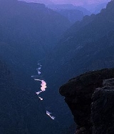
The Gunnison River is a tributary of the Colorado River, 164 miles (263.9 km) long, in the Southwest
state
of Colorado
. It is the fifth largest tributary of the Colorado River, with a mean flow of 4320 ft³/s (122 m³/s).
, formed by the confluence of Taylor
and East
rivers at Almont
. Just past the town of Gunnison
, the river begins to swell into the expanse of Blue Mesa Reservoir
, a 36 miles (57.9 km) long reservoir formed by Blue Mesa Dam, where it receives the Lake Fork of the Gunnison
. Just downstream it is dammed again to form Morrow Point Reservoir
, then just downstream of that dam for the final time to form Crystal Reservoir
. The reservoirs produce hydroelectric power and supply water for the surrounding areas for both municipal and irrigation use. The reservoirs are the upper part of the Black Canyon of the Gunnison, one of the longest, narrowest, and deepest gorges in the world. Below Crystal Dam it begins to roar through massive cataracts and flows through the deepest part of the gorge. At the outlet of the canyon it receives the North Fork River, then downstream near Delta, Colorado
is joined by the Uncompahgre River. It then winds through desert canyonlands, where it receives Kannah Creek
before it empties out of the Dominguez Canyon into the Colorado in Grand Junction
, some years rivaling the Colorado River for equal if not slightly less volume.
The Gunnison River ranges in width from 100 to 1000 ft (30.5 to 304.8 ) and 3 to 50 ft (0.9144 to 15.2 ) in depth. The river's powerful current and many rapids make upstream travel nearly impossible. It is navigable for small craft throughout its course and by larger boats below the Black Canyon. Parts of the Black Canyon are unnavigable to any sorts of craft because of giant cataracts. Navigation through the entire canyon is dangerous and for experienced boaters only.
, who came to the banks of the river just below its confluence with the Uncompahgre River
in 1761 and 1765. It was again seen in 1776 by Silvestre Vélez de Escalante. At the time the Spanish name for the river was Rio de San Javier (Xavier), and the Native American name was Tomichi. Escalante noted that Rivera thought it was "the great Rio del Tizon", the long used Spanish name for the lower Colorado River.
The river is named for U.S. Army Captain John W. Gunnison
of the Topographic Engineers who was ambushed and killed by Pahvant Utes while mapping a trail west in Utah Territory in 1857.
via the 5 miles (8 km) long Gunnison Tunnel
, which was built between 1905 and 1909. Dams on the river include Blue Mesa Dam
, Morrow Point Dam
, and Crystal Dam
.
Southwestern United States
The Southwestern United States is a region defined in different ways by different sources. Broad definitions include nearly a quarter of the United States, including Arizona, California, Colorado, Nevada, New Mexico, Oklahoma, Texas and Utah...
state
U.S. state
A U.S. state is any one of the 50 federated states of the United States of America that share sovereignty with the federal government. Because of this shared sovereignty, an American is a citizen both of the federal entity and of his or her state of domicile. Four states use the official title of...
of Colorado
Colorado
Colorado is a U.S. state that encompasses much of the Rocky Mountains as well as the northeastern portion of the Colorado Plateau and the western edge of the Great Plains...
. It is the fifth largest tributary of the Colorado River, with a mean flow of 4320 ft³/s (122 m³/s).
Description
It rises in west central Colorado, in eastern Gunnison CountyGunnison County, Colorado
Gunnison County is the fifth most extensive of the 64 counties of the state of Colorado in the United States. The county population was 15,324 at the 2010 census. The county was named for John W. Gunnison, a United States Army officer and captain in the Army Topographical Engineers, who surveyed...
, formed by the confluence of Taylor
Taylor River (Colorado)
The Taylor River rises close to Castle Peak in Colorado’s Elk Mountains in the northeast part of Gunnison County, near the Continental Divide....
and East
East River (Colorado)
East River is a stream in central Colorado. It flows south from Emerald Lake in the Maroon Bells Wilderness to a confluence with the Taylor River that forms the Gunnison River....
rivers at Almont
Almont, Colorado
Almont is an unincorporated town and U.S. Post Office in Gunnison County, Colorado, United States. The ZIP Code of the Almont Post Office is 81210.-History:...
. Just past the town of Gunnison
Gunnison, Colorado
The historic City of Gunnison, a Home Rule Municipality, is the county seat and the most populous city of Gunnison County, Colorado, United States. As of the 2010 census, the city had a population of 5,854. It was named in honor of John W...
, the river begins to swell into the expanse of Blue Mesa Reservoir
Blue Mesa Reservoir
-External links:* Blue Mesa related information.* Reservoir maps, conditions and fishing reports...
, a 36 miles (57.9 km) long reservoir formed by Blue Mesa Dam, where it receives the Lake Fork of the Gunnison
Lake Fork Gunnison River
Lake Fork Gunnison River or Lake Fork is a tributary of the Gunnison River in Colorado. The river's source is Sloan Lake near Handies Peak in the San Juan Mountains of Hinsdale County. Lake Fork flows through Lake San Cristobal and Lake City before a confluence with the Gunnison River in Blue...
. Just downstream it is dammed again to form Morrow Point Reservoir
Morrow Point Reservoir
Morrow Point Reservoir is an artificial reservoir on the Gunnison River in southwestern Colorado operated by the U.S. Bureau of Reclamation. Located in the upper Black Canyon of the Gunnison, it is impounded by tall Morrow Point Dam, and is within the National Park Service-operated Curecanti...
, then just downstream of that dam for the final time to form Crystal Reservoir
Crystal Reservoir
Crystal Reservoir is an artificial reservoir on the Gunnison River in southwestern Colorado operated by the U.S. Bureau of Reclamation. Located in the upper Black Canyon of the Gunnison, it is impounded by tall Crystal Dam, and is within the National Park Service-operated Curecanti National...
. The reservoirs produce hydroelectric power and supply water for the surrounding areas for both municipal and irrigation use. The reservoirs are the upper part of the Black Canyon of the Gunnison, one of the longest, narrowest, and deepest gorges in the world. Below Crystal Dam it begins to roar through massive cataracts and flows through the deepest part of the gorge. At the outlet of the canyon it receives the North Fork River, then downstream near Delta, Colorado
Delta, Colorado
The City of Delta is the county seat and the most populous city of Delta County, Colorado, United States. The population was 8,915 at the 2010 census...
is joined by the Uncompahgre River. It then winds through desert canyonlands, where it receives Kannah Creek
Kannah Creek
Kannah Creek is a watershed that descends from the top of the Grand Mesa west southwest, where it meets the Gunnison River about 25 miles south of Grand Junction, Colorado. It offers many recreational opportunities, irrigation, and is an important source of drinking water for Grand Junction...
before it empties out of the Dominguez Canyon into the Colorado in Grand Junction
Grand Junction, Colorado
The City of Grand Junction is the largest city in western Colorado. It is a city with a council–manager government form that is the county seat and the most populous city of Mesa County, Colorado, United States. Grand Junction is situated west-southwest of the Colorado State Capitol in Denver. As...
, some years rivaling the Colorado River for equal if not slightly less volume.
The Gunnison River ranges in width from 100 to 1000 ft (30.5 to 304.8 ) and 3 to 50 ft (0.9144 to 15.2 ) in depth. The river's powerful current and many rapids make upstream travel nearly impossible. It is navigable for small craft throughout its course and by larger boats below the Black Canyon. Parts of the Black Canyon are unnavigable to any sorts of craft because of giant cataracts. Navigation through the entire canyon is dangerous and for experienced boaters only.
History
The first non-native to see and record information of the Gunnison River was Juan Maria de RiveraJuan Rivera (explorer)
Juan Maria Antonio Rivera was an 18th century Spanish explorer who explored southwestern North America, including parts of Southern Rocky Mountains...
, who came to the banks of the river just below its confluence with the Uncompahgre River
Uncompahgre River
The Uncompahgre River is a tributary of the Gunnison River, approximately 75 mi long, in southwestern Colorado in the United States. Lake Como at 12,215 ft in northern San Juan County, in the Uncompahgre National Forest in the northwestern San Juan Mountains is the headwaters of the...
in 1761 and 1765. It was again seen in 1776 by Silvestre Vélez de Escalante. At the time the Spanish name for the river was Rio de San Javier (Xavier), and the Native American name was Tomichi. Escalante noted that Rivera thought it was "the great Rio del Tizon", the long used Spanish name for the lower Colorado River.
The river is named for U.S. Army Captain John W. Gunnison
John W. Gunnison
John Williams Gunnison was an American military officer and explorer.-Biography:Gunnison was born in Goshen, New Hampshire in 1812. He graduated from West Point in 1837, second in his class of fifty cadets. His military career began in Florida, where he spent a year in the campaign against the...
of the Topographic Engineers who was ambushed and killed by Pahvant Utes while mapping a trail west in Utah Territory in 1857.
Engineering
Part of the river's water is diverted to irrigate the Uncompahgre ValleyUncompahgre Valley
The Uncompahgre Valley is an agricultural valley of the Uncompahgre River around the town of Montrose in the western part of the U.S. state of Colorado...
via the 5 miles (8 km) long Gunnison Tunnel
Gunnison Tunnel
The Gunnison Tunnel is a 5.8 mile irrigation tunnel constructed between 1905 and 1909 by the Bureau of Reclamation. At the time of its completion, it was the longest irrigation tunnel in the world...
, which was built between 1905 and 1909. Dams on the river include Blue Mesa Dam
Blue Mesa Dam
Blue Mesa Dam is a zoned earthfill dam on the Gunnison River in Colorado. It creates Blue Mesa Reservoir, and is within Curecanti National Recreation Area just before the river enters the Black Canyon of the Gunnison. The dam is upstream of the Morrow Point Dam. Blue Mesa Dam and reservoir are...
, Morrow Point Dam
Morrow Point Dam
Morrow Point Dam is a concrete double-arch dam on the Gunnison River located in Colorado, the first dam of its type built by the U.S. Bureau of Reclamation. Located in the upper Black Canyon of the Gunnison, it creates Morrow Point Reservoir, and is within the National Park Service-operated...
, and Crystal Dam
Crystal Dam
Crystal Dam is a double curvature, concrete thin arch dam located six miles downstream from Morrow Point Dam on the Gunnison River in Colorado, USA. Crystal Dam is the newest of the three dams in Curecanti National Recreation Area; construction on the dam was finished in 1976. The dam impounds...
.