
Quaboag River
Encyclopedia
The Quaboag River is a 25.7 miles (41.4 km) river in Massachusetts
that heads at Quaboag Pond
in Brookfield
at an elevation of 594 feet (181.1 m) above sea level. It flows west to the village of Three Rivers, Massachusetts
, at an elevation of 290 feet (88.4 m).
, an Indian name meaning "red-water" (place or pond). At one time, this pond was called Podunk Pond. Early industry started along the Quaboag River downstream from West Brookfield
, where the river started a 300 feet (91.4 m) change in elevation, providing significant waterpower. Major heavy industry was located in Warren, Massachusetts
, because of the available waterpower from the river. Many of the dams on the river, used to provide waterpower, were destroyed during floods and not repaired or replaced. Parts of them remain, providing a hint of the river’s industrial past.
, flows through the towns of Brookfield
, West Brookfield
(where Lake Wickaboag drains into it), and Warren
before joining the Ware River
and Swift River in Three Rivers
, to form the Chicopee River
. This river is therefore part of the Chicopee River Watershed.
in East Brookfield drains into Quaboag Pond
, and several other significant water sources drain into it. There are also several wetlands associated with this watershed, the two mayor ones being the Great Swamp south of Brookfield, and the Allen Swamp south of East Brookfield.
and canoeists paddle the Quaboag from a put-in at Lucy Stone Park in Warren, downstream to a take-out along Route 67. The river is Class
III and features several named rapids, Mousehole and Trestle Rapid above the dam, and, downstream, Angel's Field and Devil's Gorge, which contains an abrupt four-foot waterfall called Quaboag Drop. The river has a large watershed, holds its water well (is well formed), and is runnable at levels above four feet on the Brimfield
USGS gauge. It contains one mandatory portage
around an unrunnable dam next to a factory. This dam is shown in the title block.
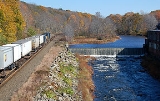
Passage through Warren
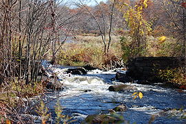
Head south of East Brookfield
Massachusetts
The Commonwealth of Massachusetts is a state in the New England region of the northeastern United States of America. It is bordered by Rhode Island and Connecticut to the south, New York to the west, and Vermont and New Hampshire to the north; at its east lies the Atlantic Ocean. As of the 2010...
that heads at Quaboag Pond
Quaboag Pond
Quaboag Pond is a pond located near the East Brookfield and Brookfield, Massachusetts. The pond lies about two miles south of state Route 9 as it passes through East Brookfield. Quaboag Pond was once named Podunk Pond.-Description:...
in Brookfield
Brookfield, Massachusetts
Brookfield is a town in Worcester County, Massachusetts, United States. The population was 3,390 at the 2010 census.-History:Brookfield was first settled in 1660 and was officially incorporated in 1718...
at an elevation of 594 feet (181.1 m) above sea level. It flows west to the village of Three Rivers, Massachusetts
Three Rivers, Massachusetts
Three Rivers is a village and former census-designated place in the town of Palmer in Hampden County, Massachusetts, United States. It is part of the Springfield, Massachusetts Metropolitan Statistical Area...
, at an elevation of 290 feet (88.4 m).
History
The river receives its name from Quaboag PondQuaboag Pond
Quaboag Pond is a pond located near the East Brookfield and Brookfield, Massachusetts. The pond lies about two miles south of state Route 9 as it passes through East Brookfield. Quaboag Pond was once named Podunk Pond.-Description:...
, an Indian name meaning "red-water" (place or pond). At one time, this pond was called Podunk Pond. Early industry started along the Quaboag River downstream from West Brookfield
West Brookfield, Massachusetts
West Brookfield is a town in Worcester County, Massachusetts, United States. The population was 3,701 at the 2010 census. Lucy Stone was born in West Brookfield, and Noah Webster published his dictionary there....
, where the river started a 300 feet (91.4 m) change in elevation, providing significant waterpower. Major heavy industry was located in Warren, Massachusetts
Warren, Massachusetts
Warren is a town in Worcester County, Massachusetts, United States. The population was 5,135 at the 2010 census.For geographic and demographic information on the census-designated place Warren, please see the article Warren , Massachusetts.- History :...
, because of the available waterpower from the river. Many of the dams on the river, used to provide waterpower, were destroyed during floods and not repaired or replaced. Parts of them remain, providing a hint of the river’s industrial past.
Description
The Quaboag River heads at Quaboag PondQuaboag Pond
Quaboag Pond is a pond located near the East Brookfield and Brookfield, Massachusetts. The pond lies about two miles south of state Route 9 as it passes through East Brookfield. Quaboag Pond was once named Podunk Pond.-Description:...
, flows through the towns of Brookfield
Brookfield, Massachusetts
Brookfield is a town in Worcester County, Massachusetts, United States. The population was 3,390 at the 2010 census.-History:Brookfield was first settled in 1660 and was officially incorporated in 1718...
, West Brookfield
West Brookfield, Massachusetts
West Brookfield is a town in Worcester County, Massachusetts, United States. The population was 3,701 at the 2010 census. Lucy Stone was born in West Brookfield, and Noah Webster published his dictionary there....
(where Lake Wickaboag drains into it), and Warren
Warren, Massachusetts
Warren is a town in Worcester County, Massachusetts, United States. The population was 5,135 at the 2010 census.For geographic and demographic information on the census-designated place Warren, please see the article Warren , Massachusetts.- History :...
before joining the Ware River
Ware River
The Ware River is a river in central Massachusetts. It has two forks, the longest of which begins near Hubbardston, Massachusetts...
and Swift River in Three Rivers
Three Rivers, Massachusetts
Three Rivers is a village and former census-designated place in the town of Palmer in Hampden County, Massachusetts, United States. It is part of the Springfield, Massachusetts Metropolitan Statistical Area...
, to form the Chicopee River
Chicopee River
The Chicopee River is an tributary of the Connecticut River in Metropolitan Springfield, Massachusetts, known for fast-moving water and its extraordinarily large basin: the Connecticut River's largest tributary basin...
. This river is therefore part of the Chicopee River Watershed.
Watershed
Numerous local brooks and streams from the towns of East Brookfield, Brookfield, West Brookfield, and Warren drain the watershed into the Quaboag River. Lake LashawayLake Lashaway
Lake Lashaway is a pond located near the East Brookfield and North Brookfield, Massachusetts town line. The town line cuts the lake approximately in half. The lake lies just to the north of state Route 9 as it passes through East Brookfield.-Description:...
in East Brookfield drains into Quaboag Pond
Quaboag Pond
Quaboag Pond is a pond located near the East Brookfield and Brookfield, Massachusetts. The pond lies about two miles south of state Route 9 as it passes through East Brookfield. Quaboag Pond was once named Podunk Pond.-Description:...
, and several other significant water sources drain into it. There are also several wetlands associated with this watershed, the two mayor ones being the Great Swamp south of Brookfield, and the Allen Swamp south of East Brookfield.
Recreational use
Whitewater kayakersWhitewater kayaking
Whitewater kayaking is the sport of paddling a kayak on a moving body of water, typically a whitewater river. Whitewater kayaking can range from simple, carefree gently moving water, to demanding, dangerous whitewater. River rapids are graded like ski runs according to the difficulty, danger or...
and canoeists paddle the Quaboag from a put-in at Lucy Stone Park in Warren, downstream to a take-out along Route 67. The river is Class
International Scale of River Difficulty
The International Scale of River Difficulty is a standardized scale used to rate the safety of a stretch of river, or a single rapid. The grade reflects the technical difficulty and skill level required associated with the section of river...
III and features several named rapids, Mousehole and Trestle Rapid above the dam, and, downstream, Angel's Field and Devil's Gorge, which contains an abrupt four-foot waterfall called Quaboag Drop. The river has a large watershed, holds its water well (is well formed), and is runnable at levels above four feet on the Brimfield
Brimfield, Massachusetts
Brimfield is a town in Hampden County, Massachusetts, United States. The population was 3,609 at the 2010 census. It is part of the Springfield, Massachusetts Metropolitan Statistical Area.-Geography:...
USGS gauge. It contains one mandatory portage
Portage
Portage or portaging refers to the practice of carrying watercraft or cargo over land to avoid river obstacles, or between two bodies of water. A place where this carrying occurs is also called a portage; a person doing the carrying is called a porter.The English word portage is derived from the...
around an unrunnable dam next to a factory. This dam is shown in the title block.
Coordinates
Mouth in Three RiversThree Rivers, Massachusetts
Three Rivers is a village and former census-designated place in the town of Palmer in Hampden County, Massachusetts, United States. It is part of the Springfield, Massachusetts Metropolitan Statistical Area...
Passage through Warren
Warren, Massachusetts
Warren is a town in Worcester County, Massachusetts, United States. The population was 5,135 at the 2010 census.For geographic and demographic information on the census-designated place Warren, please see the article Warren , Massachusetts.- History :...
Head south of East Brookfield
East Brookfield, Massachusetts
East Brookfield is a town in Worcester County, Massachusetts, United States. The population was 2,183 at the 2010 census.For geographic and demographic information on the census-designated place East Brookfield, please see the article East Brookfield , Massachusetts.- History :East Brookfield was...