
Watauga River
Encyclopedia
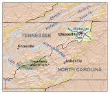
The Watauga River is a large stream
of western North Carolina
and East Tennessee
. It is 60 miles (97 km) long with its headwaters on the slopes of Grandfather Mountain
and Peak Mountain
in Watauga County, North Carolina
.
. The river then flows across the Tennessee
state line at Johnson County. Crossing into Johnson County, the Watauga River is first impounded by the Tennessee Valley Authority
(TVA) Watauga Dam
, creating the 6430 acres (2,602.1 ha) Watauga Lake
. This earth impoundment of the Watauga River receives two important tributaries, the Elk River
and Roan Creek
, whose former valley of bottom land forms a very large embayment of Watauga Lake.
Watauga Lake is bridged by Tennessee State Route 67
at Butler Bridge just as the watercourse enters Carter County, Tennessee
. The Appalachian Trail
crosses the Watauga River at Watauga Dam.
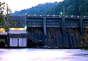
 Just below Watauga Dam on the Horseshoe section of the Watauga River is the TVA Wilbur Dam
, an impoundment which forms a much smaller but very deep reservoir known as Wilbur Lake that releases approximately 130 cuft/s of discharged water back into the Watauga River during the summer months.
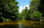
The Watauga River flows generally north and then west into Carter County where it forms the northern limits of Elizabethton
, where the Watauga then receives the Doe River
. Further downstream on the Watauga River at the boundary between Carter County and Washington County is the old TVA Watauga Steam Plant.
A considerable portion of the boundary line between Washington County and Sullivan County is formed by the Watauga River. Boone Lake is located below the slackwater confluence of both the downstream end of the Watauga River and the South Holston River
. The distance afloat between the TVA Watauga Reservoir and Boone Lake is approximately 20.6 miles (33.2 km).
 The word "Watauga" comes from the Cherokee
, who had several towns so named, including one at present-day Elizabethton, which became known as "Watauga Old Fields", first explored by Daniel Boone
and James Robertson
in 1759. A larger Cherokee town called Watauga was located on the Little Tennessee River
near Franklin, North Carolina
. The Cherokee word is more accurately written Watagi. Other common spellings include Watoda, Wattoogee, and Whatoga. A North Carolina State University
web page (The Watauga Medal) cites that the word "Watauga" is a Native-American word meaning "the land beyond", however local reference to the name origin is attributed to the meaning "beautiful river" or "beautiful water".
The original settlers of Nashville, Tennessee
, set out from the Watauga River area, called the Watauga Association
, during the American Revolution
when they realized that the British
Proclamation of 1763 forbidding settlement of its colonists west of the Blue Ridge Mountains
was essentially unenforceable.
Wibur Dam is the site of first hydroelectric
dam constructed in Tennessee (beginning in 1909), going online with power production and distribution in 1912. It was constructed by the former Tennessee Electric Power Company, a privately-owned utility purchased by TVA in the late 1930s. Elizabethton acquired the moniker "City of Power" because of the early local access to hydro-generated electricity from Wilbur Dam.
, canoeing
, fly fishing
, and angling
with fishing reel
s are all popular recreation activities pursued on the Watauga River. Rainbow trout
, brown trout
, and striped bass
are all caught in the Watauga River.
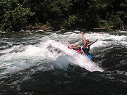
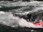 The Watauga River downstream of the TVA dams draws commercial rafting outfitters from both northeast Tennessee and western North Carolina during the summer months and commercial fishing guides throughout the year.The picturesque Class II+ Bee Cliff Rapids
on the Watauga River (also referred to the "Anaconda Rapids" by some North Carolina-based rafting companies) are found downstream between Wilbur Dam and the Siam Bridge, southeast of Elizabethton, Tennessee
.
For commercial whitewater rafting and kayaking on the Watauga River, the most popular Carter County "put-in" for is immediately downstream of the TVA Wilbur Dam, and the most popular "take-out" is 2 to 2½ hours downstream (depending upon the volume of the reservoir release and other factors) at the Blackbottom riverside portion of the city linear trail park in Elizabethton.
 The distance afloat for paddlers from the put-in at Wilbur Dam to the Blackbottom take-out is approximately seven miles with landmarks along the Watauga River providing good estimate of time and distance traveled.
The Watauga also has a section of Class IV-V whitewater popular with expert kayakers, upstream of Watauga Lake. This section requires significant rainfall to bring it up to runnable levels. It features continuous steep boulder bed rapids dropping up to 150 ft/mi, and several falls and ledges only runnable by expert paddlers.
, hiking
trail
, walking trail, wildlife
viewing area, birdwatching
.
(TVA) regulates flow of the Watauga River by scheduling the release of deep, impounded reservoir waters from behind both the TVA Watauga Dam and the TVA Wilbur Dam. As a result, the summer temperature of the Watauga River is approximately downstream of the TVA dams. The Watauga River is generally comfortable for kayaking
, canoeing
, and rafting during the summer months, but care must be taken to prevent hypothermia
by prolonged exposure to the cold river water.
As TVA also guarantees a minimum release schedule during the summer season for riverine recreation below the TVA Wilbur Dam, the Watauga River will draw commercial whitewater rafting companies from distant rivers ---such as the Nolichucky River
running through Erwin, Tennessee
in Unicoi County--- when lack of adequate summer rain fall will not allow for rafting trips on these naturally flowing rivers during seasonal droughts
.
Stream
A stream is a body of water with a current, confined within a bed and stream banks. Depending on its locale or certain characteristics, a stream may be referred to as a branch, brook, beck, burn, creek, "crick", gill , kill, lick, rill, river, syke, bayou, rivulet, streamage, wash, run or...
of western North Carolina
North Carolina
North Carolina is a state located in the southeastern United States. The state borders South Carolina and Georgia to the south, Tennessee to the west and Virginia to the north. North Carolina contains 100 counties. Its capital is Raleigh, and its largest city is Charlotte...
and East Tennessee
East Tennessee
East Tennessee is a name given to approximately the eastern third of the U.S. state of Tennessee, one of the three Grand Divisions of Tennessee defined in state law. East Tennessee consists of 33 counties, 30 located within the Eastern Time Zone and three counties in the Central Time Zone, namely...
. It is 60 miles (97 km) long with its headwaters on the slopes of Grandfather Mountain
Grandfather Mountain
Grandfather Mountain is a mountain, a non-profit attraction, and a North Carolina state parknear Linville, North Carolina. At 5,946 feet , it is the highest peak on the eastern escarpment of the Blue Ridge Mountains, one of the major chains of the Appalachian Mountains. The Blue Ridge Parkway...
and Peak Mountain
Peak Mountain (North Carolina)
Peak Mountain is a mountain in the North Carolina High Country, near the town of Seven Devils. It is wholly in the Pisgah National Forest. Its elevation reaches ....
in Watauga County, North Carolina
Watauga County, North Carolina
-Demographics:As of the census of 2000, there were 42,695 people, 16,540 households, and 9,411 families residing in the county. The population density was 137 people per square mile . There were 23,155 housing units at an average density of 74 per square mile...
.
Hydrography
The Watauga River is formed by the confluence of the Shanty Spring Branch and the Green Ridge Branch in Watauga County, North CarolinaWatauga County, North Carolina
-Demographics:As of the census of 2000, there were 42,695 people, 16,540 households, and 9,411 families residing in the county. The population density was 137 people per square mile . There were 23,155 housing units at an average density of 74 per square mile...
. The river then flows across the Tennessee
Tennessee
Tennessee is a U.S. state located in the Southeastern United States. It has a population of 6,346,105, making it the nation's 17th-largest state by population, and covers , making it the 36th-largest by total land area...
state line at Johnson County. Crossing into Johnson County, the Watauga River is first impounded by the Tennessee Valley Authority
Tennessee Valley Authority
The Tennessee Valley Authority is a federally owned corporation in the United States created by congressional charter in May 1933 to provide navigation, flood control, electricity generation, fertilizer manufacturing, and economic development in the Tennessee Valley, a region particularly affected...
(TVA) Watauga Dam
Watauga Dam
Watauga Dam is a hydroelectric and flood control dam on the Watauga River in Carter County, in the U.S. state of Tennessee. It is owned and operated by the Tennessee Valley Authority, which built the dam in the 1940s as part of efforts to control flooding in the Tennessee River watershed...
, creating the 6430 acres (2,602.1 ha) Watauga Lake
Watauga Lake
Watauga Lake, located southeast of Elizabethton, Tennessee, was created by the Tennessee Valley Authority with the completion of the TVA Watauga Dam and Reservoir....
. This earth impoundment of the Watauga River receives two important tributaries, the Elk River
Elk River (North Carolina)
The Elk River is a large stream in the North Carolina High Country and East Tennessee. The headwaters begin from the Northwestern slopes of Peak Mountain in Avery County, North Carolina and end at the Watauga River in Carter County, Tennessee.-Hydrography:...
and Roan Creek
Roan Creek
Roan Creek rises on the Tennessee and North Carolina border, in Johnson County, Tennessee, near the town of Trade, Tennessee. It flows through Cherokee National Forest to join the Watauga River in Watauga Lake, the reservoir behind Watauga Dam....
, whose former valley of bottom land forms a very large embayment of Watauga Lake.
Watauga Lake is bridged by Tennessee State Route 67
Tennessee State Route 67
State Route 67 is a state-maintained highway in northeastern Tennessee, including a four-lane divided highway segments in both Washington County and Carter County, and part of a significant two-lane segment passing over the Butler Bridge some above the TVA Watauga Reservoir near Butler in Johnson...
at Butler Bridge just as the watercourse enters Carter County, Tennessee
Carter County, Tennessee
Carter County is a county located in the U.S. state of Tennessee. As of 2010, the population was 57,424. Its county seat is Elizabethton.Carter County is part of the Johnson City Metropolitan Statistical Area, which is a component of the Johnson City–Kingsport–Bristol, TN-VA Combined...
. The Appalachian Trail
Appalachian Trail
The Appalachian National Scenic Trail, generally known as the Appalachian Trail or simply the AT, is a marked hiking trail in the eastern United States extending between Springer Mountain in Georgia and Mount Katahdin in Maine. It is approximately long...
crosses the Watauga River at Watauga Dam.
Wilbur Dam
Wilbur Dam is a hydroelectric dam on the Watauga River in Carter County, in the U.S. state of Tennessee. It is one of two dams on the river owned and operated by the Tennessee Valley Authority. The dam impounds Wilbur Lake, which extends for about up the Watauga to the base of Watauga Dam...
, an impoundment which forms a much smaller but very deep reservoir known as Wilbur Lake that releases approximately 130 cuft/s of discharged water back into the Watauga River during the summer months.
The Watauga River flows generally north and then west into Carter County where it forms the northern limits of Elizabethton
Elizabethton, Tennessee
Elizabethton is the county seat of Carter County, Tennessee, United States. Elizabethton is also the historical site both of the first independent American government located west of both the Eastern Continental Divide and the original thirteen British American colonies.Elizabethton is also the...
, where the Watauga then receives the Doe River
Doe River
The Doe River is a naturally flowing river in northeast Tennessee that forms in Carter County near the North Carolina line, just south of Roan Mountain State Park.-Hydrography:...
. Further downstream on the Watauga River at the boundary between Carter County and Washington County is the old TVA Watauga Steam Plant.
A considerable portion of the boundary line between Washington County and Sullivan County is formed by the Watauga River. Boone Lake is located below the slackwater confluence of both the downstream end of the Watauga River and the South Holston River
Holston River
The Holston River is a major river system of southwestern Virginia and east Tennessee. The three major forks of the Holston rise in southwestern Virginia and have their confluence near Kingsport, Tennessee. The North Fork flows southwest from Sharon Springs in Bland County, Virginia...
. The distance afloat between the TVA Watauga Reservoir and Boone Lake is approximately 20.6 miles (33.2 km).
History
Cherokee
The Cherokee are a Native American people historically settled in the Southeastern United States . Linguistically, they are part of the Iroquoian language family...
, who had several towns so named, including one at present-day Elizabethton, which became known as "Watauga Old Fields", first explored by Daniel Boone
Daniel Boone
Daniel Boone was an American pioneer, explorer, and frontiersman whose frontier exploits mad']'e him one of the first folk heroes of the United States. Boone is most famous for his exploration and settlement of what is now the Commonwealth of Kentucky, which was then beyond the western borders of...
and James Robertson
James Robertson (early American)
James Robertson was an explorer and pioneer active primarily in what is now the State of Tennessee during the second half of the 18th century. An early companion of explorer Daniel Boone, Robertson helped establish the Watauga Association in the early 1770s, and helped defend Fort Watauga from an...
in 1759. A larger Cherokee town called Watauga was located on the Little Tennessee River
Little Tennessee River
The Little Tennessee River is a tributary of the Tennessee River, approximately 135 miles long, in the Appalachian Mountains in the southeastern United States.-Geography:...
near Franklin, North Carolina
Franklin, North Carolina
Franklin is a town in Franklin Township, Macon County, North Carolina, United States, within the Nantahala National Forest. The population was 3,490 as of the 2000 census. It is the county seat of Macon County. Franklin is an official Appalachian Trail friendly destination...
. The Cherokee word is more accurately written Watagi. Other common spellings include Watoda, Wattoogee, and Whatoga. A North Carolina State University
North Carolina State University
North Carolina State University at Raleigh is a public, coeducational, extensive research university located in Raleigh, North Carolina, United States. Commonly known as NC State, the university is part of the University of North Carolina system and is a land, sea, and space grant institution...
web page (The Watauga Medal) cites that the word "Watauga" is a Native-American word meaning "the land beyond", however local reference to the name origin is attributed to the meaning "beautiful river" or "beautiful water".
The original settlers of Nashville, Tennessee
Nashville, Tennessee
Nashville is the capital of the U.S. state of Tennessee and the county seat of Davidson County. It is located on the Cumberland River in Davidson County, in the north-central part of the state. The city is a center for the health care, publishing, banking and transportation industries, and is home...
, set out from the Watauga River area, called the Watauga Association
Watauga Association
The Watauga Association was a semi-autonomous government created in 1772 by frontier settlers living along the Watauga River in what is now present day Elizabethton, Tennessee...
, during the American Revolution
American Revolution
The American Revolution was the political upheaval during the last half of the 18th century in which thirteen colonies in North America joined together to break free from the British Empire, combining to become the United States of America...
when they realized that the British
Kingdom of Great Britain
The former Kingdom of Great Britain, sometimes described as the 'United Kingdom of Great Britain', That the Two Kingdoms of Scotland and England, shall upon the 1st May next ensuing the date hereof, and forever after, be United into One Kingdom by the Name of GREAT BRITAIN. was a sovereign...
Proclamation of 1763 forbidding settlement of its colonists west of the Blue Ridge Mountains
Blue Ridge Mountains
The Blue Ridge Mountains are a physiographic province of the larger Appalachian Mountains range. This province consists of northern and southern physiographic regions, which divide near the Roanoke River gap. The mountain range is located in the eastern United States, starting at its southern-most...
was essentially unenforceable.
Wibur Dam is the site of first hydroelectric
Hydroelectricity
Hydroelectricity is the term referring to electricity generated by hydropower; the production of electrical power through the use of the gravitational force of falling or flowing water. It is the most widely used form of renewable energy...
dam constructed in Tennessee (beginning in 1909), going online with power production and distribution in 1912. It was constructed by the former Tennessee Electric Power Company, a privately-owned utility purchased by TVA in the late 1930s. Elizabethton acquired the moniker "City of Power" because of the early local access to hydro-generated electricity from Wilbur Dam.
Recreation
Whitewater rafting, kayakingWhitewater kayaking
Whitewater kayaking is the sport of paddling a kayak on a moving body of water, typically a whitewater river. Whitewater kayaking can range from simple, carefree gently moving water, to demanding, dangerous whitewater. River rapids are graded like ski runs according to the difficulty, danger or...
, canoeing
Canoeing
Canoeing is an outdoor activity that involves a special kind of canoe.Open canoes may be 'poled' , sailed, 'lined and tracked' or even 'gunnel-bobbed'....
, fly fishing
Fly fishing
Fly fishing is an angling method in which an artificial 'fly' is used to catch fish. The fly is cast using a fly rod, reel, and specialized weighted line. Casting a nearly weightless fly or 'lure' requires casting techniques significantly different from other forms of casting...
, and angling
Angling
Angling is a method of fishing by means of an "angle" . The hook is usually attached to a fishing line and the line is often attached to a fishing rod. Fishing rods are usually fitted with a fishing reel that functions as a mechanism for storing, retrieving and paying out the line. The hook itself...
with fishing reel
Fishing reel
A fishing reel is a "cylindrical device attached to a fishing rod used in winding the line". Modern fishing reels usually have fittings which make it easier to retrieve the line and deploy it for better accuracy or distance. Fishing reels are traditionally used in the recreational sport of angling...
s are all popular recreation activities pursued on the Watauga River. Rainbow trout
Rainbow trout
The rainbow trout is a species of salmonid native to tributaries of the Pacific Ocean in Asia and North America. The steelhead is a sea run rainbow trout usually returning to freshwater to spawn after 2 to 3 years at sea. In other words, rainbow trout and steelhead trout are the same species....
, brown trout
Brown trout
The brown trout and the sea trout are fish of the same species....
, and striped bass
Striped bass
The striped bass is the state fish of Maryland, Rhode Island, South Carolina, and the state saltwater fish of New York, Virginia, and New Hampshire...
are all caught in the Watauga River.
Whitewater
Bee Cliff (Tennessee)
The Bee Cliff is a prominent northeast Tennessee geological limestone feature with high caves that overlooks the Watauga River and the Siam community of Carter County, Tennessee.-Geography:...
on the Watauga River (also referred to the "Anaconda Rapids" by some North Carolina-based rafting companies) are found downstream between Wilbur Dam and the Siam Bridge, southeast of Elizabethton, Tennessee
Elizabethton, Tennessee
Elizabethton is the county seat of Carter County, Tennessee, United States. Elizabethton is also the historical site both of the first independent American government located west of both the Eastern Continental Divide and the original thirteen British American colonies.Elizabethton is also the...
.
For commercial whitewater rafting and kayaking on the Watauga River, the most popular Carter County "put-in" for is immediately downstream of the TVA Wilbur Dam, and the most popular "take-out" is 2 to 2½ hours downstream (depending upon the volume of the reservoir release and other factors) at the Blackbottom riverside portion of the city linear trail park in Elizabethton.
| Wilbur Dam to Bee Cliff Rapids | - 15 minutes |
| Wilbur Dam to Siam Bridge | - 45 minutes |
| Wilbur Dam to Hunter Bridge (TWRA put-in/take out) | - 75 minutes |
| Wilbur Dam to Gilbert Peters Bridge at US 19-E in Elizabethton | - 105 minutes |
| Wilbur Dam to Bristol Bridge in Elizabethton | - 135 minutes |
The Watauga also has a section of Class IV-V whitewater popular with expert kayakers, upstream of Watauga Lake. This section requires significant rainfall to bring it up to runnable levels. It features continuous steep boulder bed rapids dropping up to 150 ft/mi, and several falls and ledges only runnable by expert paddlers.
TVA recreation areas
The Tennessee Valley Authority maintains a self-service public campground below Watauga Dam. Amenities and recreational opportunities at the TVA Watauga Dam Tailwater Campground include 29 camp sites with electric hookups, rest rooms with heated showers and flush toilets, dump station, public phone, picnic tables and grills, canoe access, boat ramps above and below dam, lake and river fishingFishing
Fishing is the activity of trying to catch wild fish. Fish are normally caught in the wild. Techniques for catching fish include hand gathering, spearing, netting, angling and trapping....
, hiking
Hiking
Hiking is an outdoor activity which consists of walking in natural environments, often in mountainous or other scenic terrain. People often hike on hiking trails. It is such a popular activity that there are numerous hiking organizations worldwide. The health benefits of different types of hiking...
trail
Trail
A trail is a path with a rough beaten or dirt/stone surface used for travel. Trails may be for use only by walkers and in some places are the main access route to remote settlements...
, walking trail, wildlife
Wildlife
Wildlife includes all non-domesticated plants, animals and other organisms. Domesticating wild plant and animal species for human benefit has occurred many times all over the planet, and has a major impact on the environment, both positive and negative....
viewing area, birdwatching
Birdwatching
Birdwatching or birding is the observation of birds as a recreational activity. It can be done with the naked eye, through a visual enhancement device like binoculars and telescopes, or by listening for bird sounds. Birding often involves a significant auditory component, as many bird species are...
.
Influence of weather
The Tennessee Valley AuthorityTennessee Valley Authority
The Tennessee Valley Authority is a federally owned corporation in the United States created by congressional charter in May 1933 to provide navigation, flood control, electricity generation, fertilizer manufacturing, and economic development in the Tennessee Valley, a region particularly affected...
(TVA) regulates flow of the Watauga River by scheduling the release of deep, impounded reservoir waters from behind both the TVA Watauga Dam and the TVA Wilbur Dam. As a result, the summer temperature of the Watauga River is approximately downstream of the TVA dams. The Watauga River is generally comfortable for kayaking
Kayaking
Kayaking is the use of a kayak for moving across water. Kayaking and canoeing are also known as paddling. Kayaking is distinguished from canoeing by the sitting position of the paddler and the number of blades on the paddle...
, canoeing
Canoeing
Canoeing is an outdoor activity that involves a special kind of canoe.Open canoes may be 'poled' , sailed, 'lined and tracked' or even 'gunnel-bobbed'....
, and rafting during the summer months, but care must be taken to prevent hypothermia
Hypothermia
Hypothermia is a condition in which core temperature drops below the required temperature for normal metabolism and body functions which is defined as . Body temperature is usually maintained near a constant level of through biologic homeostasis or thermoregulation...
by prolonged exposure to the cold river water.
As TVA also guarantees a minimum release schedule during the summer season for riverine recreation below the TVA Wilbur Dam, the Watauga River will draw commercial whitewater rafting companies from distant rivers ---such as the Nolichucky River
Nolichucky River
The Nolichucky River is a major stream draining the Blue Ridge Mountains of western North Carolina and east Tennessee. The river is long.-Hydrography:...
running through Erwin, Tennessee
Erwin, Tennessee
Erwin is a town in and the county seat of Unicoi County, Tennessee, United States. The population was 5,610 at the 2000 census. It is part of the Johnson City Metropolitan Statistical Area, which is a component of the Johnson City–Kingsport–Bristol, TN-VA Combined Statistical Area...
in Unicoi County--- when lack of adequate summer rain fall will not allow for rafting trips on these naturally flowing rivers during seasonal droughts
Drought
A drought is an extended period of months or years when a region notes a deficiency in its water supply. Generally, this occurs when a region receives consistently below average precipitation. It can have a substantial impact on the ecosystem and agriculture of the affected region...
.
| Month | Jan | Feb | Mar | Apr | May | Jun | Jul | Aug | Sep | Oct | Nov | Dec | Annual |
|---|---|---|---|---|---|---|---|---|---|---|---|---|---|
| Avg °F(°C) | |
|
|
|
|
|
|
|
|
|
|
|
|
| Avg high °F(°C) | |
|
|
|
|
|
|
|
|
|
|
|
|
| Avg low °F(°C) | -4.3°C |
-2.9°C |
|
|
|
|
|
|
|
|
|
|
|
| Rain (inches) | |
|
|
|
|
|
|
|
|
|
|
|
|
| Snow (inches) | |
|
|
|
|
|
|
|
|
|
|
|
|
climate-zone.com |
|||||||||||||