
.gif)
Bee Cliff (Tennessee)
Encyclopedia
The Bee Cliff is a prominent northeast Tennessee
geological limestone
feature with high caves that overlooks the Watauga River
and the Siam community of Carter County, Tennessee
.
 Bee Cliff is located in northeastern Tennessee at 36°21′07"N 82°08′11"W 36.351944° North, -82.136389° West.
The lower face of the Bee Cliff is across and immediately above the Watauga River
from Wilbur Dam Road.
The summit of the Bee Cliff is located off Blue Springs Road across the Watauga River from theWilbur Dam Road .
The elevation
at the Bee Cliff summit is 1968 feet (599.8 m).
Wilbur
and Watauga
dam
s and approximately one hour and forty-five minutes upstream of the city of Elizabethton, Tennessee
.
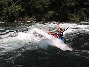
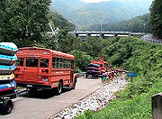 For whitewater rafting and kayaking on the Watauga River, the most popular Carter County "put-in" for whitewater rafting is found immediately downstream of the Wilbur Dam and the most popular "take-out" is found approximately 2 to 2½ hours downstream (depending upon the volume of the reservoir release and other factors) at the Blackbottom riverside portion of the linear trail in Elizabethton. While floating downstream "straight shot" on the Watauga River, you can reference several local landmarks in order to estimate your length of time and distance on the river to Elizabethton:
The distance afloat from the put-in at Wilbur Dam to the Blackbottom take-out is approximately seven miles (11 km).
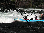 Immediately before the Bee Cliff is an approximate one-hundred and fifty yard stretch of Class I and Class II whitewater
rapids on the Watauga River known locally as the Bee Cliff Rapids (although some North Carolina river guides mistakenly refer to this run as the Anaconda Rapids). The Bee Cliff Rapids are approximately 15 to 20 minutes downstream of the TVA Wilbur Dam "put-in" or launch.
On the left-hand (port) downstream side of the Bee Cliff Rapids (and on the opposite side of the Watauga River from the Bee Cliff) is a private, wooded area with trails --- utilized by commercial rating companies with paid landing permit --- running parallel with and further downstream from the Bee Cliff Rapids. Locals also refer to this particular wooded section of the Watauga River as "Bee Cliff'.
The classification of these rapids by the International Scale of River Difficulty
at the Bee Cliff are largely dependent upon the scheduled release of impounded reservoir water from behind the Tennessee Valley Authority Wilbur and Watauga Dams. TVA runs a summer release schedule that frequently provides for what local river guides refer to as being a "full load" , meaning that the Bee Cliff Rapids can approach Class II and Class III (especially when the TVA is also releasing water over the Wilbur Dam spillways).
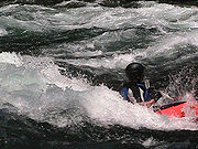
, canoeing
, fly fishing
, and angling
with fishing reel
s are all popular recreation activities pursued at the Bee Cliff. Rainbow trout
, brown trout
, and striped bass
are all caught in the Watauga River.
 The Watauga River downstream of the TVA dams draws commercial rafting outfitters from both northeast Tennessee and western North Carolina during the summer months and commercial fishing guides throughout the year.The picturesque Class II+ Bee Cliff Rapids on the Watauga River (also referred to the "Anaconda Rapids" by some North Carolina-based rafting companies) are found downstream between Wilbur Dam and the Siam Bridge, southeast of Elizabethton, Tennessee
.
For commercial whitewater rafting and kayaking on the Watauga River, the most popular Carter County "put-in" for is immediately downstream of the TVA Wilbur Dam, and the most popular "take-out" is 2 to 2½ hours downstream (depending upon the volume of the reservoir release and other factors) at the Blackbottom riverside portion of the city linear trail park in Elizabethton.
 The distance afloat for paddlers from the put-in at Wilbur Dam to the Blackbottom take-out is approximately seven miles with landmarks along the Watauga River providing good estimate of time and distance traveled.
The Watauga also has a section of Class IV-V whitewater popular with expert kayakers, upstream of Watauga Lake. This section requires significant rainfall to bring it up to runnable levels. It features continuous steep boulder bed rapids dropping up to 150 ft/mi, and several falls and ledges only runnable by expert paddlers.
, hiking
trail
, walking trail, wildlife
viewing area, birdwatching
.
(TVA) regulates flow of the Watauga River by scheduling the release of deep, impounded reservoir waters from behind both the TVA Watauga Dam and the TVA Wilbur Dam. As a result, the summer temperature of the Watauga River at the Bee Cliff is approximately . The Watauga River is generally comfortable for kayaking
, canoeing
, and rafting during the summer months, but care must be taken to prevent hypothermia
by prolonged exposure to the cold river water.
As TVA also guarantees a minimum release schedule during the summer season for rivine recreation below the TVA Wilbur Dam, the Watauga River will draw commercial whitewater rafting companies from distant rivers ---such as the Nolichucky River
running through Erwin, Tennessee
in Unicoi County--- when lack of adequate summer rain fall will not allow for rafting trips on these naturally flowing rivers during seasonal droughts
.
action film Delta Force 2: The Colombian Connection
were filmed at the Bee Cliff and other Carter County sites:
Tennessee
Tennessee is a U.S. state located in the Southeastern United States. It has a population of 6,346,105, making it the nation's 17th-largest state by population, and covers , making it the 36th-largest by total land area...
geological limestone
Limestone
Limestone is a sedimentary rock composed largely of the minerals calcite and aragonite, which are different crystal forms of calcium carbonate . Many limestones are composed from skeletal fragments of marine organisms such as coral or foraminifera....
feature with high caves that overlooks the Watauga River
Watauga River
The Watauga River is a large stream of western North Carolina and East Tennessee. It is 60 miles long with its headwaters on the slopes of Grandfather Mountain and Peak Mountain in Watauga County, North Carolina.-Hydrography:...
and the Siam community of Carter County, Tennessee
Carter County, Tennessee
Carter County is a county located in the U.S. state of Tennessee. As of 2010, the population was 57,424. Its county seat is Elizabethton.Carter County is part of the Johnson City Metropolitan Statistical Area, which is a component of the Johnson City–Kingsport–Bristol, TN-VA Combined...
.
Geography
The lower face of the Bee Cliff is across and immediately above the Watauga River
Watauga River
The Watauga River is a large stream of western North Carolina and East Tennessee. It is 60 miles long with its headwaters on the slopes of Grandfather Mountain and Peak Mountain in Watauga County, North Carolina.-Hydrography:...
from Wilbur Dam Road.
The summit of the Bee Cliff is located off Blue Springs Road across the Watauga River from theWilbur Dam Road .
The elevation
Elevation
The elevation of a geographic location is its height above a fixed reference point, most commonly a reference geoid, a mathematical model of the Earth's sea level as an equipotential gravitational surface ....
at the Bee Cliff summit is 1968 feet (599.8 m).
Travel afloat
By travel afloat on the Watauga River, the Bee Cliff is located approximately 10 to 15 minutes downstream from the Tennessee Valley AuthorityTennessee Valley Authority
The Tennessee Valley Authority is a federally owned corporation in the United States created by congressional charter in May 1933 to provide navigation, flood control, electricity generation, fertilizer manufacturing, and economic development in the Tennessee Valley, a region particularly affected...
Wilbur
Wilbur Dam
Wilbur Dam is a hydroelectric dam on the Watauga River in Carter County, in the U.S. state of Tennessee. It is one of two dams on the river owned and operated by the Tennessee Valley Authority. The dam impounds Wilbur Lake, which extends for about up the Watauga to the base of Watauga Dam...
and Watauga
Watauga Dam
Watauga Dam is a hydroelectric and flood control dam on the Watauga River in Carter County, in the U.S. state of Tennessee. It is owned and operated by the Tennessee Valley Authority, which built the dam in the 1940s as part of efforts to control flooding in the Tennessee River watershed...
dam
Dam
A dam is a barrier that impounds water or underground streams. Dams generally serve the primary purpose of retaining water, while other structures such as floodgates or levees are used to manage or prevent water flow into specific land regions. Hydropower and pumped-storage hydroelectricity are...
s and approximately one hour and forty-five minutes upstream of the city of Elizabethton, Tennessee
Elizabethton, Tennessee
Elizabethton is the county seat of Carter County, Tennessee, United States. Elizabethton is also the historical site both of the first independent American government located west of both the Eastern Continental Divide and the original thirteen British American colonies.Elizabethton is also the...
.
- approximately thirty minutes to float downstream to the old iron bridge at the Siam community (long stretch of flat water);
- approximately sixty minutes to float to the first concrete bridge at the Hunter community (beginning of brief swift and punchy rapidRapidA rapid is a section of a river where the river bed has a relatively steep gradient causing an increase in water velocity and turbulence. A rapid is a hydrological feature between a run and a cascade. A rapid is characterised by the river becoming shallower and having some rocks exposed above the...
s on right bank); - approximately ninety minutes to float to the concrete U.S. Highway 19E bridge and Carter Mansion(coming on fast rapids onto steep left bank) at Elizabethton, and;
- approximately one hundred twenty minutes (two hours) to float to the Blackbottom "take-out" in Elizabethton.
The distance afloat from the put-in at Wilbur Dam to the Blackbottom take-out is approximately seven miles (11 km).
Difficulty of the rapids
Whitewater
Whitewater is formed in a rapid, when a river's gradient increases enough to disturb its laminar flow and create turbulence, i.e. form a bubbly, or aerated and unstable current; the frothy water appears white...
rapids on the Watauga River known locally as the Bee Cliff Rapids (although some North Carolina river guides mistakenly refer to this run as the Anaconda Rapids). The Bee Cliff Rapids are approximately 15 to 20 minutes downstream of the TVA Wilbur Dam "put-in" or launch.
On the left-hand (port) downstream side of the Bee Cliff Rapids (and on the opposite side of the Watauga River from the Bee Cliff) is a private, wooded area with trails --- utilized by commercial rating companies with paid landing permit --- running parallel with and further downstream from the Bee Cliff Rapids. Locals also refer to this particular wooded section of the Watauga River as "Bee Cliff'.
The classification of these rapids by the International Scale of River Difficulty
International Scale of River Difficulty
The International Scale of River Difficulty is a standardized scale used to rate the safety of a stretch of river, or a single rapid. The grade reflects the technical difficulty and skill level required associated with the section of river...
at the Bee Cliff are largely dependent upon the scheduled release of impounded reservoir water from behind the Tennessee Valley Authority Wilbur and Watauga Dams. TVA runs a summer release schedule that frequently provides for what local river guides refer to as being a "full load" , meaning that the Bee Cliff Rapids can approach Class II and Class III (especially when the TVA is also releasing water over the Wilbur Dam spillways).
Water hazards
There are several minor water hazards at the Bee Cliff Rapids that paddlers should keep in mind:- Personal flotation devices (life jackets) and water footwear are required;
- The water temperature is approximately 53 °F (11.7 °C) (even during the summer months) as this impounded reservoir water being released from behind a dam;
- Be aware that the "Big Hole" (formed by water dropping over an underwater ledge) is found approximately 10 to 20 ft (3 to 6.1 ) off the downstream port (left) bank near the end of the Bee Cliff Rapids;
- Rain and prevailing wind conditions through the Siam valley often create thick blankets of fog following moderate to heavy rain storms;
- Steep underwater slides are found in the center-to-starboard (right) downstream bottom section of the Bee Cliff Rapids that can easily flip a canoe end-over-end;
- A sharp-edged and small limestoneLimestoneLimestone is a sedimentary rock composed largely of the minerals calcite and aragonite, which are different crystal forms of calcium carbonate . Many limestones are composed from skeletal fragments of marine organisms such as coral or foraminifera....
bolder found above the waterline that has punctured inflatable rafts is located at the downstream starboard (right) bank immediately at the end of the Bee Cliff Rapids.
Recreation
Whitewater rafting, kayakingWhitewater kayaking
Whitewater kayaking is the sport of paddling a kayak on a moving body of water, typically a whitewater river. Whitewater kayaking can range from simple, carefree gently moving water, to demanding, dangerous whitewater. River rapids are graded like ski runs according to the difficulty, danger or...
, canoeing
Canoeing
Canoeing is an outdoor activity that involves a special kind of canoe.Open canoes may be 'poled' , sailed, 'lined and tracked' or even 'gunnel-bobbed'....
, fly fishing
Fly fishing
Fly fishing is an angling method in which an artificial 'fly' is used to catch fish. The fly is cast using a fly rod, reel, and specialized weighted line. Casting a nearly weightless fly or 'lure' requires casting techniques significantly different from other forms of casting...
, and angling
Angling
Angling is a method of fishing by means of an "angle" . The hook is usually attached to a fishing line and the line is often attached to a fishing rod. Fishing rods are usually fitted with a fishing reel that functions as a mechanism for storing, retrieving and paying out the line. The hook itself...
with fishing reel
Fishing reel
A fishing reel is a "cylindrical device attached to a fishing rod used in winding the line". Modern fishing reels usually have fittings which make it easier to retrieve the line and deploy it for better accuracy or distance. Fishing reels are traditionally used in the recreational sport of angling...
s are all popular recreation activities pursued at the Bee Cliff. Rainbow trout
Rainbow trout
The rainbow trout is a species of salmonid native to tributaries of the Pacific Ocean in Asia and North America. The steelhead is a sea run rainbow trout usually returning to freshwater to spawn after 2 to 3 years at sea. In other words, rainbow trout and steelhead trout are the same species....
, brown trout
Brown trout
The brown trout and the sea trout are fish of the same species....
, and striped bass
Striped bass
The striped bass is the state fish of Maryland, Rhode Island, South Carolina, and the state saltwater fish of New York, Virginia, and New Hampshire...
are all caught in the Watauga River.
Whitewater
Elizabethton, Tennessee
Elizabethton is the county seat of Carter County, Tennessee, United States. Elizabethton is also the historical site both of the first independent American government located west of both the Eastern Continental Divide and the original thirteen British American colonies.Elizabethton is also the...
.
For commercial whitewater rafting and kayaking on the Watauga River, the most popular Carter County "put-in" for is immediately downstream of the TVA Wilbur Dam, and the most popular "take-out" is 2 to 2½ hours downstream (depending upon the volume of the reservoir release and other factors) at the Blackbottom riverside portion of the city linear trail park in Elizabethton.
| Wilbur Dam to Bee Cliff Rapids | - 15 minutes |
| Wilbur Dam to Siam Bridge | - 45 minutes |
| Wilbur Dam to Hunter Bridge (TWRA put-in/take out) | - 75 minutes |
| Wilbur Dam to Gilbert Peters Bridge at US 19-E in Elizabethton | - 105 minutes |
| Wilbur Dam to Bristol Bridge in Elizabethton | - 135 minutes |
The Watauga also has a section of Class IV-V whitewater popular with expert kayakers, upstream of Watauga Lake. This section requires significant rainfall to bring it up to runnable levels. It features continuous steep boulder bed rapids dropping up to 150 ft/mi, and several falls and ledges only runnable by expert paddlers.
TVA recreation areas
The Tennessee Valley Authority maintains a self-service public campground just minutes upstream of the Bee Cliff. Amenities and recreational opportunities at the TVA Watauga Dam Tailwater Campground include 29 camp sites with electric hookups, rest rooms with heated showers and flush toilets, dump station, public phone, picnic tables and grills, canoe access, boat ramps above and below dam, lake and river fishingFishing
Fishing is the activity of trying to catch wild fish. Fish are normally caught in the wild. Techniques for catching fish include hand gathering, spearing, netting, angling and trapping....
, hiking
Hiking
Hiking is an outdoor activity which consists of walking in natural environments, often in mountainous or other scenic terrain. People often hike on hiking trails. It is such a popular activity that there are numerous hiking organizations worldwide. The health benefits of different types of hiking...
trail
Trail
A trail is a path with a rough beaten or dirt/stone surface used for travel. Trails may be for use only by walkers and in some places are the main access route to remote settlements...
, walking trail, wildlife
Wildlife
Wildlife includes all non-domesticated plants, animals and other organisms. Domesticating wild plant and animal species for human benefit has occurred many times all over the planet, and has a major impact on the environment, both positive and negative....
viewing area, birdwatching
Birdwatching
Birdwatching or birding is the observation of birds as a recreational activity. It can be done with the naked eye, through a visual enhancement device like binoculars and telescopes, or by listening for bird sounds. Birding often involves a significant auditory component, as many bird species are...
.
Influence of weather
The Tennessee Valley AuthorityTennessee Valley Authority
The Tennessee Valley Authority is a federally owned corporation in the United States created by congressional charter in May 1933 to provide navigation, flood control, electricity generation, fertilizer manufacturing, and economic development in the Tennessee Valley, a region particularly affected...
(TVA) regulates flow of the Watauga River by scheduling the release of deep, impounded reservoir waters from behind both the TVA Watauga Dam and the TVA Wilbur Dam. As a result, the summer temperature of the Watauga River at the Bee Cliff is approximately . The Watauga River is generally comfortable for kayaking
Kayaking
Kayaking is the use of a kayak for moving across water. Kayaking and canoeing are also known as paddling. Kayaking is distinguished from canoeing by the sitting position of the paddler and the number of blades on the paddle...
, canoeing
Canoeing
Canoeing is an outdoor activity that involves a special kind of canoe.Open canoes may be 'poled' , sailed, 'lined and tracked' or even 'gunnel-bobbed'....
, and rafting during the summer months, but care must be taken to prevent hypothermia
Hypothermia
Hypothermia is a condition in which core temperature drops below the required temperature for normal metabolism and body functions which is defined as . Body temperature is usually maintained near a constant level of through biologic homeostasis or thermoregulation...
by prolonged exposure to the cold river water.
As TVA also guarantees a minimum release schedule during the summer season for rivine recreation below the TVA Wilbur Dam, the Watauga River will draw commercial whitewater rafting companies from distant rivers ---such as the Nolichucky River
Nolichucky River
The Nolichucky River is a major stream draining the Blue Ridge Mountains of western North Carolina and east Tennessee. The river is long.-Hydrography:...
running through Erwin, Tennessee
Erwin, Tennessee
Erwin is a town in and the county seat of Unicoi County, Tennessee, United States. The population was 5,610 at the 2000 census. It is part of the Johnson City Metropolitan Statistical Area, which is a component of the Johnson City–Kingsport–Bristol, TN-VA Combined Statistical Area...
in Unicoi County--- when lack of adequate summer rain fall will not allow for rafting trips on these naturally flowing rivers during seasonal droughts
Drought
A drought is an extended period of months or years when a region notes a deficiency in its water supply. Generally, this occurs when a region receives consistently below average precipitation. It can have a substantial impact on the ecosystem and agriculture of the affected region...
.
| Month | Jan | Feb | Mar | Apr | May | Jun | Jul | Aug | Sep | Oct | Nov | Dec | Annual |
|---|---|---|---|---|---|---|---|---|---|---|---|---|---|
| Avg °F(°C) | |
|
|
|
|
|
|
|
|
|
|
|
|
| Avg high °F(°C) | |
|
|
|
|
|
|
|
|
|
|
|
|
| Avg low °F(°C) | -4.3°C |
-2.9°C |
|
|
|
|
|
|
|
|
|
|
|
| Rain (inches) | |
|
|
|
|
|
|
|
|
|
|
|
|
| Snow (inches) | |
|
|
|
|
|
|
|
|
|
|
|
|
climate-zone.com |
|||||||||||||
Motion picture scene filmed at the Bee Cliff
During 1989, many scenes from the Chuck NorrisChuck Norris
Carlos Ray "Chuck" Norris is an American martial artist and actor. After serving in the United States Air Force, he began his rise to fame as a martial artist and has since founded his own school, Chun Kuk Do...
action film Delta Force 2: The Colombian Connection
Delta Force 2: The Colombian Connection
Delta Force 2 is a 1990 action film, and a sequel to the Chuck Norris film, The Delta Force , also starring Norris as Maj. Scott McCoy...
were filmed at the Bee Cliff and other Carter County sites:
- Filmed in the Philippines, Elizabethton, TennesseeElizabethton, TennesseeElizabethton is the county seat of Carter County, Tennessee, United States. Elizabethton is also the historical site both of the first independent American government located west of both the Eastern Continental Divide and the original thirteen British American colonies.Elizabethton is also the...
, and other various Carter County, TennesseeCarter County, TennesseeCarter County is a county located in the U.S. state of Tennessee. As of 2010, the population was 57,424. Its county seat is Elizabethton.Carter County is part of the Johnson City Metropolitan Statistical Area, which is a component of the Johnson City–Kingsport–Bristol, TN-VA Combined...
locations such as Buck Mountain and the Bee Cliff. The "Palace In The Sky" resort in Tagaytay was used as the setting for Ramon Cota's hideout. The interior set of the Cota's hideout (and the sets from many other interior scenes) from Delta Force 2 were actually constructed within the warehouse of former shampoo manufacturer in Elizabethton. Shampoo labels with an Elvis-like caricature for "Love Me Tender Shampoo" were found still attached to columns within the warehouse stage.
- A long shot showing the Colonel Scot McCoy character (played in the movie by Chuck NorrisChuck NorrisCarlos Ray "Chuck" Norris is an American martial artist and actor. After serving in the United States Air Force, he began his rise to fame as a martial artist and has since founded his own school, Chun Kuk Do...
) climbing a towering cliff face in order to invade Ramon Cota's palace was filmed in the Philippines, but the accompanying close-up shot of McCoy pausing on the cliff face was actually shot at the river level base of the Bee Cliff with Norris and film crew aboard inflatable rafts while filming this close-up afloat on the Watauga River.