
.gif)
Green River (Utah)
Encyclopedia
The Green River, located in the western United States
, is the chief tributary of the Colorado River
. The watershed
of the river, known as the Green River Basin, covers parts of Wyoming
, Utah
, and Colorado
. The Green River is 730 miles (1,174.8 km) long, beginning in the Wind River Mountains of Wyoming and flowing through Wyoming and Utah for most of its course, except for 40 miles (64.4 km) into western Colorado. Much of the route is through the Colorado Plateau
and through some of the most spectacular canyon
s in the United States
. It is only slightly smaller than the Colorado when the two rivers merge, but typically carries a larger load of silt
. The average yearly mean flow of the river at Green River, Utah
is 6121 cubic feet (173.3 m³) per second.
The status of the Green River as a tributary of the Colorado River came about for mainly political reasons. In earlier nomenclature, the Colorado River began at its confluence with the Green River. Above the confluence the Colorado was called the Grand River. In 1921, Colorado
U.S. Representative Edward T. Taylor
petitioned the Congressional Committee on Interstate and Foreign Commerce
to rename the Grand River as the Colorado River. On July 25, 1921 the name change was made official in House Joint Resolution 460 of the 66th Congress
, over the objections of representatives from Wyoming
and Utah
and the United States Geological Survey
which noted that the drainage basin of the Green River was more than 70% more extensive than that of the Grand River, although the Grand carried a slightly higher volume of water at its confluence with the Green.
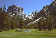 It rises in western Wyoming, in northern Sublette County, on the western side of the Continental Divide
in the Bridger-Teton National Forest
in the Wind River Range
. It flows south through Sublette County and western Wyoming in an area known as the Upper Green River Valley, then southwest and is joined by the Big Sandy River
in western Sweetwater County. At the town of La Barge, it flows into Fontenelle Reservoir, formed by Fontenelle Dam. Below there, it flows through open sage covered rolling prairie where it is crossed by the Oregon
, California
and Mormon
emigration trails and then further south until it flows past the town of Green River
and into the Flaming Gorge Reservoir
in Southwestern Wyoming, formed by the Flaming Gorge Dam
in northeastern Utah. Prior to the creation of the reservoir, the Blacks Fork
joined the Green River south of Green River, today the mouth of Blacks Fork is submerged by the reservoir.
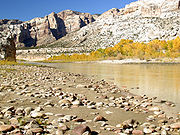 South of the dam it flows eastward, looping around the eastern tip of the Uinta Mountains
going from Utah into northwestern Colorado and through Browns Park before turning west and then south into Dinosaur National Monument
where it passes through the Canyon of the Lodore (Otherwise known as the Gates of Lodore) and is joined by the Yampa River
at Steamboat Rock. It turns westward back into Utah along the southern edge of the Uintas in Whirlpool Canyon. In Utah it meanders southwest across the Yampa Plateau and through the Uintah and Ouray Indian Reservation
and the Ouray National Wildlife Refuge
. Two miles south of Ouray, Utah, it is joined by Duchesne River
, and three miles (5 km) downstream by the White River
. Ten miles farther downstream it is joined by the Willow River.
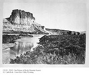
South of the plateau, it is joined by the Nine Mile River, then enters the Roan Cliffs where it flows south through the back-to-back Desolation
and Gray Canyons, with a combined length of 120 mi (192 km). In Gray Canyon, it is joined by the Price River
. South of the canyon it passes the town of Green River, Utah
and is joined by the San Rafael River
in southern Emery County
. In eastern Wayne County
it meanders through Canyonlands National Park
where it joins the Colorado.
The Flaming Gorge Dam in Utah is a significant regional source of water for irrigation and mining, as well as for hydroelectric power. Begun in the 1950s and finished in 1963, it was highly controversial and opposed by conservationists. Originally, a dam was to be built in Whirlpool Canyon, but the conservationist movement traded the Flaming Gorge dam for halting that proposal. Apocryphally, the Sierra Club
, a not-for-profit environmental organization, lost its tax-exempt status for opposing the proposed dam.
The Green is a large, deep, powerful river. It ranges from 100 to 300 feet (30 to 100 m) wide in the upper course to 300 to 1500 feet (457.2 m) wide in its lower course and ranges from 3 to 50 feet (1 to 15 m) in depth. It is navigable by small craft throughout its course and by large motorboats upstream to Flaming Gorge Dam. Near the areas where the Oregon Trail crosses, the river is 400 - 500 feet (152.4 m) wide and averages about 20 feet (6.1 m) deep at normal flow.
 Archaeological
evidence indicates that the tributary canyons and sheltered areas in the river valley were home to the Fremont Culture, which flourished from the 7th century to the 13th century. The Fremont were a semi-nomadic people who lived in pithouses and are best known for the rock art on canyon walls and in sheltered overhangs.
In later centuries, the river basin was home to the Shoshone
and Ute
peoples, both nomadic hunters. The Shoshone inhabited the river valley north of the Uinta Mountains
, whereas the Utes lived to the south. The current reservation of the Utes is in the Uinta Basin. The Shoshone
called the river the Seeds-kee-dee-Agie, meaning "Prairie Hen River."
In 1776, the Spanish friars Silvestre Vélez de Escalante and Francisco Atanasio Domínguez crossed the river near present-day Jensen, naming it the Rio de San Buenaventura
. The map-maker of the expedition, Captain Bernardo Miera y Pacheco, erroneously indicated that the river flowed southwest to what is now known as Sevier Lake
. Later cartographers extended the error, representing the Buenaventura River as flowing into the Pacific Ocean
. At least one charted the Buenaventura as draining the Great Salt Lake
. Later Spanish and Mexican explorers adopted the name Rio Verde, meaning "Green River" in Spanish
. Exactly when the Spanish started using this name and why is unknown. Explanations of the name "Green" include ideas about the color of the water (though it is usually just as red as that of the Colorado), the color of soapstone along its banks, the color of the vegetation, and the name of a trapper. No explanation can be verified.http://historytogo.utah.gov/utah_chapters/the_land/greenriver.html Wilson Hunt of John Jacob Astor
's Pacific Fur Company
called it The Spanish River in 1811. By that time it was clear to the trappers that Miera's map (if they had seen it) was wrong, for they had learned from the Native Americans that the Green River drained to the Colorado River and the Gulf of California
. When Jedediah Smith
reached the lower Colorado in 1826 he at first called it the Seedskeedee, as the Green/Colorado River was commonly known among the trappers. By the time of Bonneville's expedition in 1832, the names "Seeds-kee-dee", "Spanish River", "Green River", and even "Colorado River" were used interchageably by the trappers and American explorers.
While it was known that the Green River drained to the Colorado, the exact course was not known. Miera's map showed the Colorado River branching into two major streams - the Nabajoo (San Juan) and the Zaguananas. It also showed the Zaguananas branching into four heads, including the Dolores and the Rafael (the latter of which Escalante's journal equates with the Colorado per information from the Native Americans). A map of 1847 redirects the course of the Rafael to the north and labels it as Green River. It would be some time before the true confluence of the Green and Colorado Rivers would be known.
The Old Spanish Trail
from New Mexico
to California
crossed the river just above the present-day town of Green River, Utah.
In the early 19th century, the upper river in Wyoming was part of the disputed Oregon Country
. It was explored by trappers from the North West Company
and Hudson's Bay Company
, such as Donald Mackenzie who pioneered the area, from 1819. In 1825, the American William Ashley and party of American explorers floated down the river from north of the Uintah Mountains to the mouth of the White River
. The valley of the river became increasingly used as a wintering ground for American trappers in the next decades, with trading posts established at the mouth of the White near Whiterocks, Utah
, and Browns Park. The Upper Green River Rendezvous Site
near Pinedale, Wyoming
was a popular location for annual mountain man
rendezvous during the 1820s and 1830s, with as many as 450 to 500 trappers attending during its heyday in the 1830s.
The region was explored by John C. Fremont
on several of his expeditions in the 1840s. Fremont corrected the cartographic error of Miera, establishing firmly that the river did not drain the Great Salt Lake. In 1869, the river was surveyed and mapped by John Wesley Powell
as part of the first of his two expeditions to the region. During his two voyages in 1869 and 1871, he and his men gave most of the current names of the canyons, geographic features, and rapids along the river.
From the 1840s through the 1860s hundreds of thousands of emigrants made their way west along the Oregon
, California
and Mormon
emigration trails. Nearly all of the primary emigration routes had to cross the Green River at some point. The main trail crossed near where the Big Sandy River
joins the Green River in Wyoming. The river is too big and deep to ford, and is the largest, most dangerous river crossed by the Oregon Trail. For that reason, ferries were commonly run on this stretch of the river. Some of the popular ferries included the Lombard and Robinson ferries at the main crossing, and the Mormon, Mountain Man, and Names Hill ferries where the popular Sublette-Greenwood cutoff crossed the river further upstream.
In 1878 the first permanent settlement in the river valley was founded at Vernal
by a party of Mormons
led by Jeremiah Hatch. The settlement survived a diphtheria
epidemic its first winter, as well as a panic caused by the Meeker Massacre in Colorado. The town is currently the largest in the Green River Valley.
Most of the land in the valley of the river today is owned and controlled by the federal government. Private holdings are largely limited to bottoms. Until the 1940s, the economy of the valley was based largely on ranching. Tourism has emerged as the dominant industry in the region in the last several decades.
at the Ashley Field after World War II
has led to the exploitation of oil and natural gas
in the region. The Green River Formation
is said to have the largest fossil fuel deposits in the world. in the form of oil shale
. There is estimated to be between 500 billion and 1.1 trillion barrels (80 and 175 km³) of potentially recoverable oil in the basin.
The Green River Basin contains the world's largest known deposit of trona
ore near Green River, Wyoming. Soda ash mining from trona veins 900 and 1600 feet (300 and 500 m) deep is a major industrial activity in the area, employing over 2000 persons at four mines. The mining operation is less expensive for production of soda ash in the United States than the synthetic Solvay process
, which predominates in the rest of the world.
The area has been mined for uranium
.
United States
The United States of America is a federal constitutional republic comprising fifty states and a federal district...
, is the chief tributary of the Colorado River
Colorado River
The Colorado River , is a river in the Southwestern United States and northwestern Mexico, approximately long, draining a part of the arid regions on the western slope of the Rocky Mountains. The watershed of the Colorado River covers in parts of seven U.S. states and two Mexican states...
. The watershed
Drainage basin
A drainage basin is an extent or an area of land where surface water from rain and melting snow or ice converges to a single point, usually the exit of the basin, where the waters join another waterbody, such as a river, lake, reservoir, estuary, wetland, sea, or ocean...
of the river, known as the Green River Basin, covers parts of Wyoming
Wyoming
Wyoming is a state in the mountain region of the Western United States. The western two thirds of the state is covered mostly with the mountain ranges and rangelands in the foothills of the Eastern Rocky Mountains, while the eastern third of the state is high elevation prairie known as the High...
, Utah
Utah
Utah is a state in the Western United States. It was the 45th state to join the Union, on January 4, 1896. Approximately 80% of Utah's 2,763,885 people live along the Wasatch Front, centering on Salt Lake City. This leaves vast expanses of the state nearly uninhabited, making the population the...
, and Colorado
Colorado
Colorado is a U.S. state that encompasses much of the Rocky Mountains as well as the northeastern portion of the Colorado Plateau and the western edge of the Great Plains...
. The Green River is 730 miles (1,174.8 km) long, beginning in the Wind River Mountains of Wyoming and flowing through Wyoming and Utah for most of its course, except for 40 miles (64.4 km) into western Colorado. Much of the route is through the Colorado Plateau
Colorado Plateau
The Colorado Plateau, also called the Colorado Plateau Province, is a physiographic region of the Intermontane Plateaus, roughly centered on the Four Corners region of the southwestern United States. The province covers an area of 337,000 km2 within western Colorado, northwestern New Mexico,...
and through some of the most spectacular canyon
Canyon
A canyon or gorge is a deep ravine between cliffs often carved from the landscape by a river. Rivers have a natural tendency to reach a baseline elevation, which is the same elevation as the body of water it will eventually drain into. This forms a canyon. Most canyons were formed by a process of...
s in the United States
United States
The United States of America is a federal constitutional republic comprising fifty states and a federal district...
. It is only slightly smaller than the Colorado when the two rivers merge, but typically carries a larger load of silt
Silt
Silt is granular material of a size somewhere between sand and clay whose mineral origin is quartz and feldspar. Silt may occur as a soil or as suspended sediment in a surface water body...
. The average yearly mean flow of the river at Green River, Utah
Green River, Utah
Green River is a city in Emery County, Utah, United States. The population was 973 at the 2000 census.-Geography:Green River is located at , on the banks of the Green River, after which the city is named. The San Rafael Swell region is to the west of Green River, while Canyonlands National Park...
is 6121 cubic feet (173.3 m³) per second.
The status of the Green River as a tributary of the Colorado River came about for mainly political reasons. In earlier nomenclature, the Colorado River began at its confluence with the Green River. Above the confluence the Colorado was called the Grand River. In 1921, Colorado
Colorado
Colorado is a U.S. state that encompasses much of the Rocky Mountains as well as the northeastern portion of the Colorado Plateau and the western edge of the Great Plains...
U.S. Representative Edward T. Taylor
Edward T. Taylor
Edward Thomas Taylor was a U.S. Representative from Colorado.Taylor was born on a farm near Metamora, Illinois. He attended the common schools of Illinois and Kansas, and graduated from the high school at Leavenworth, Kansas, in 1881. Taylor moved to Leadville, Colorado and was principal of...
petitioned the Congressional Committee on Interstate and Foreign Commerce
United States House Committee on Energy and Commerce
The Committee on Energy and Commerce is one of the oldest standing committees of the United States House of Representatives. Established in 1795, it has operated continuously—with various name changes and jurisdictional changes—for more than 200 years...
to rename the Grand River as the Colorado River. On July 25, 1921 the name change was made official in House Joint Resolution 460 of the 66th Congress
66th United States Congress
The Sixty-sixth United States Congress was a meeting of the legislative branch of the United States federal government, comprising the United States Senate and the United States House of Representatives. It met in Washington, DC from March 4, 1919 to March 4, 1921, during the last two years of...
, over the objections of representatives from Wyoming
Wyoming
Wyoming is a state in the mountain region of the Western United States. The western two thirds of the state is covered mostly with the mountain ranges and rangelands in the foothills of the Eastern Rocky Mountains, while the eastern third of the state is high elevation prairie known as the High...
and Utah
Utah
Utah is a state in the Western United States. It was the 45th state to join the Union, on January 4, 1896. Approximately 80% of Utah's 2,763,885 people live along the Wasatch Front, centering on Salt Lake City. This leaves vast expanses of the state nearly uninhabited, making the population the...
and the United States Geological Survey
United States Geological Survey
The United States Geological Survey is a scientific agency of the United States government. The scientists of the USGS study the landscape of the United States, its natural resources, and the natural hazards that threaten it. The organization has four major science disciplines, concerning biology,...
which noted that the drainage basin of the Green River was more than 70% more extensive than that of the Grand River, although the Grand carried a slightly higher volume of water at its confluence with the Green.
Description
Continental Divide
The Continental Divide of the Americas, or merely the Continental Gulf of Division or Great Divide, is the name given to the principal, and largely mountainous, hydrological divide of the Americas that separates the watersheds that drain into the Pacific Ocean from those river systems that drain...
in the Bridger-Teton National Forest
Bridger-Teton National Forest
Bridger-Teton National Forest is located in western Wyoming, United States. The forest consists of , making it the second largest National Forest outside of Alaska. The forest stretches from Yellowstone National Park, along the eastern boundary of Grand Teton National Park and from there rides...
in the Wind River Range
Wind River Range
The Wind River Range , is a mountain range of the Rocky Mountains in western Wyoming in the United States. The range runs roughly NW-SE for approximately 100 miles . The Continental Divide follows the crest of the range and includes Gannett Peak, which at 13,804 feet , is the highest peak...
. It flows south through Sublette County and western Wyoming in an area known as the Upper Green River Valley, then southwest and is joined by the Big Sandy River
Big Sandy River (Wyoming)
right|thumb|300px|Big Sandy Creek, WyomingThe Big Sandy River is a tributary of the Green River in Wyoming in the United States....
in western Sweetwater County. At the town of La Barge, it flows into Fontenelle Reservoir, formed by Fontenelle Dam. Below there, it flows through open sage covered rolling prairie where it is crossed by the Oregon
Oregon Trail
The Oregon Trail is a historic east-west wagon route that connected the Missouri River to valleys in Oregon and locations in between.After 1840 steam-powered riverboats and steamboats traversing up and down the Ohio, Mississippi and Missouri rivers sped settlement and development in the flat...
, California
California Trail
The California Trail was an emigrant trail of about across the western half of the North American continent from Missouri River towns to what is now the state of California...
and Mormon
Mormon Trail
The Mormon Trail or Mormon Pioneer Trail is the 1,300 mile route that members of The Church of Jesus Christ of Latter-day Saints traveled from 1846 to 1868...
emigration trails and then further south until it flows past the town of Green River
Green River, Wyoming
Green River is a city in and the county seat of Sweetwater County, Wyoming, United States, in the southwestern part of the state. The population was 11,808 at the 2000 census....
and into the Flaming Gorge Reservoir
Flaming Gorge Reservoir
Flaming Gorge Reservoir is a reservoir in Wyoming and Utah, on the Green River, created by Flaming Gorge Dam. Construction on the dam began in 1958 and was completed in 1964...
in Southwestern Wyoming, formed by the Flaming Gorge Dam
Flaming Gorge Dam
The Flaming Gorge Dam is a concrete thin-arch dam in the Flaming Gorge of the Green River, a major tributary of the Colorado River, in the U.S. state of Utah. One of the largest dams in the American West, Flaming Gorge Dam forms the Flaming Gorge Reservoir, which extends into southern Wyoming,...
in northeastern Utah. Prior to the creation of the reservoir, the Blacks Fork
Blacks Fork
Blacks Fork is a tributary of the Green River in Utah and Wyoming. The river rises on the northern side of the Uinta Mountains as the combination of three streams draining the area around Tokewanna Peak near the Utah-Wyoming border...
joined the Green River south of Green River, today the mouth of Blacks Fork is submerged by the reservoir.
Uinta Mountains
The Uinta Mountains are a high chain of mountains in northeastern Utah and extreme northwestern Colorado in the United States. A subrange of the Rocky Mountains, they are unusual for being the highest range in the contiguous United States running east to west, and lie approximately east of Salt...
going from Utah into northwestern Colorado and through Browns Park before turning west and then south into Dinosaur National Monument
Dinosaur National Monument
Dinosaur National Monument is a National Monument located on the southeast flank of the Uinta Mountains on the border between Colorado and Utah at the confluence of the Green and Yampa Rivers. Although most of the monument area is in Moffat County, Colorado, the Dinosaur Quarry is located in Utah...
where it passes through the Canyon of the Lodore (Otherwise known as the Gates of Lodore) and is joined by the Yampa River
Yampa River
The Yampa River is a tributary of the Green River, approximately 250 mi long, in the U.S. state of Colorado. It's located in the Southwestern United States...
at Steamboat Rock. It turns westward back into Utah along the southern edge of the Uintas in Whirlpool Canyon. In Utah it meanders southwest across the Yampa Plateau and through the Uintah and Ouray Indian Reservation
Uintah and Ouray Indian Reservation
The Uintah and Ouray Indian Reservation is located in northeastern Utah, USA. It is the homeland of the Northern Ute Tribe, and is the largest of three Indian reservations inhabited by members of the Ute Tribe of Native Americans. It lies in parts of seven counties; in descending order of land area...
and the Ouray National Wildlife Refuge
Ouray National Wildlife Refuge
Ouray National Wildlife Refuge is a wildlife refuge in central Uintah County, Utah in the northeastern part of the state...
. Two miles south of Ouray, Utah, it is joined by Duchesne River
Duchesne River
The Duchesne River, located in Uintah Basin region of Utah in the western United States, is a tributary of the Green River. The watershed of the river covers the Northeastern corner of Utah...
, and three miles (5 km) downstream by the White River
White River (Utah)
The White River is a tributary of the Green River, approximately long, in the U.S. states of Colorado and Utah. Flows vary from 450 ft³/s late summers in dry years to well over 12,000 ft³/s in spring....
. Ten miles farther downstream it is joined by the Willow River.
South of the plateau, it is joined by the Nine Mile River, then enters the Roan Cliffs where it flows south through the back-to-back Desolation
Desolation Canyon (Utah)
Desolation Canyon is a remote canyon on the Green River in the eastern part of the U.S. state of Utah. It was traversed by John Wesley Powell in 1869 as part of an expedition that was sponsored by the Smithsonian Institution....
and Gray Canyons, with a combined length of 120 mi (192 km). In Gray Canyon, it is joined by the Price River
Price River
The Price River is a river in the state of Utah, in the United States. The river originates in the Wasatch Plateau in central Utah and flows southeastward through Price Canyon, alongside U.S. Route 6, to the cities of Helper and Price...
. South of the canyon it passes the town of Green River, Utah
Green River, Utah
Green River is a city in Emery County, Utah, United States. The population was 973 at the 2000 census.-Geography:Green River is located at , on the banks of the Green River, after which the city is named. The San Rafael Swell region is to the west of Green River, while Canyonlands National Park...
and is joined by the San Rafael River
San Rafael River (Utah)
The San Rafael River is a tributary of the Green River, approximately long, in east central Utah in the United States. The river flows across a sparsely populated arid region of the Colorado Plateau, and is known for the isolated, scenic gorge through which it flows.It rises in northwestern...
in southern Emery County
Emery County, Utah
Emery County is a county located in the U.S. state of Utah. As of 2000 the population was 10,860, and by 2009 had been estimated to decrease to 10,629. It was named for George W. Emery, governor of the Utah Territory in 1875...
. In eastern Wayne County
Wayne County, Utah
Wayne County is a county located in the U.S. state of Utah. It was formed from Piute County in 1892. The county gets its name from a man who served as delegate to the constitutional convention, in honor of his son who was dragged to death by a horse. As of 2000 the population was 2,509, and by...
it meanders through Canyonlands National Park
Canyonlands National Park
Canyonlands National Park is a U.S. National Park located in southeastern Utah near the town of Moab and preserves a colorful landscape eroded into countless canyons, mesas and buttes by the Colorado River, the Green River, and their respective tributaries. The park is divided into four districts:...
where it joins the Colorado.
The Flaming Gorge Dam in Utah is a significant regional source of water for irrigation and mining, as well as for hydroelectric power. Begun in the 1950s and finished in 1963, it was highly controversial and opposed by conservationists. Originally, a dam was to be built in Whirlpool Canyon, but the conservationist movement traded the Flaming Gorge dam for halting that proposal. Apocryphally, the Sierra Club
Sierra Club
The Sierra Club is the oldest, largest, and most influential grassroots environmental organization in the United States. It was founded on May 28, 1892, in San Francisco, California, by the conservationist and preservationist John Muir, who became its first president...
, a not-for-profit environmental organization, lost its tax-exempt status for opposing the proposed dam.
The Green is a large, deep, powerful river. It ranges from 100 to 300 feet (30 to 100 m) wide in the upper course to 300 to 1500 feet (457.2 m) wide in its lower course and ranges from 3 to 50 feet (1 to 15 m) in depth. It is navigable by small craft throughout its course and by large motorboats upstream to Flaming Gorge Dam. Near the areas where the Oregon Trail crosses, the river is 400 - 500 feet (152.4 m) wide and averages about 20 feet (6.1 m) deep at normal flow.
History
Archaeology
Archaeology, or archeology , is the study of human society, primarily through the recovery and analysis of the material culture and environmental data that they have left behind, which includes artifacts, architecture, biofacts and cultural landscapes...
evidence indicates that the tributary canyons and sheltered areas in the river valley were home to the Fremont Culture, which flourished from the 7th century to the 13th century. The Fremont were a semi-nomadic people who lived in pithouses and are best known for the rock art on canyon walls and in sheltered overhangs.
In later centuries, the river basin was home to the Shoshone
Shoshone
The Shoshone or Shoshoni are a Native American tribe in the United States with three large divisions: the Northern, the Western and the Eastern....
and Ute
Ute Tribe
The Ute are an American Indian people now living primarily in Utah and Colorado. There are three Ute tribal reservations: Uintah-Ouray in northeastern Utah ; Southern Ute in Colorado ; and Ute Mountain which primarily lies in Colorado, but extends to Utah and New Mexico . The name of the state of...
peoples, both nomadic hunters. The Shoshone inhabited the river valley north of the Uinta Mountains
Uinta Mountains
The Uinta Mountains are a high chain of mountains in northeastern Utah and extreme northwestern Colorado in the United States. A subrange of the Rocky Mountains, they are unusual for being the highest range in the contiguous United States running east to west, and lie approximately east of Salt...
, whereas the Utes lived to the south. The current reservation of the Utes is in the Uinta Basin. The Shoshone
Shoshone
The Shoshone or Shoshoni are a Native American tribe in the United States with three large divisions: the Northern, the Western and the Eastern....
called the river the Seeds-kee-dee-Agie, meaning "Prairie Hen River."
In 1776, the Spanish friars Silvestre Vélez de Escalante and Francisco Atanasio Domínguez crossed the river near present-day Jensen, naming it the Rio de San Buenaventura
Buenaventura River (legend)
The non-existent Buenaventura River, alternatively San Buenaventura River, Río Buenaventura, etc. was once believed to run from the Rocky Mountains to the Pacific Ocean in what is now the western United States...
. The map-maker of the expedition, Captain Bernardo Miera y Pacheco, erroneously indicated that the river flowed southwest to what is now known as Sevier Lake
Sevier Lake
Sevier Lake is an intermittent and endorheic lake which lies in the lowest part of the Sevier Desert, Millard County, Utah. Like Great Salt Lake and Utah Lake, it is a remnant of Pleistocene Lake Bonneville. Sevier Lake is fed primarily by the Beaver and Sevier rivers, and the additional inflow...
. Later cartographers extended the error, representing the Buenaventura River as flowing into the Pacific Ocean
Pacific Ocean
The Pacific Ocean is the largest of the Earth's oceanic divisions. It extends from the Arctic in the north to the Southern Ocean in the south, bounded by Asia and Australia in the west, and the Americas in the east.At 165.2 million square kilometres in area, this largest division of the World...
. At least one charted the Buenaventura as draining the Great Salt Lake
Great Salt Lake
The Great Salt Lake, located in the northern part of the U.S. state of Utah, is the largest salt water lake in the western hemisphere, the fourth-largest terminal lake in the world. In an average year the lake covers an area of around , but the lake's size fluctuates substantially due to its...
. Later Spanish and Mexican explorers adopted the name Rio Verde, meaning "Green River" in Spanish
Spanish language
Spanish , also known as Castilian , is a Romance language in the Ibero-Romance group that evolved from several languages and dialects in central-northern Iberia around the 9th century and gradually spread with the expansion of the Kingdom of Castile into central and southern Iberia during the...
. Exactly when the Spanish started using this name and why is unknown. Explanations of the name "Green" include ideas about the color of the water (though it is usually just as red as that of the Colorado), the color of soapstone along its banks, the color of the vegetation, and the name of a trapper. No explanation can be verified.http://historytogo.utah.gov/utah_chapters/the_land/greenriver.html Wilson Hunt of John Jacob Astor
John Jacob Astor
John Jacob Astor , born Johann Jakob Astor, was a German-American business magnate and investor who was the first prominent member of the Astor family and the first multi-millionaire in the United States...
's Pacific Fur Company
Pacific Fur Company
The Pacific Fur Company was founded June 23, 1810, in New York City. Half of the stock of the company was held by the American Fur Company, owned exclusively by John Jacob Astor, and Astor provided all of the capital for the enterprise. The other half of the stock was ascribed to working partners...
called it The Spanish River in 1811. By that time it was clear to the trappers that Miera's map (if they had seen it) was wrong, for they had learned from the Native Americans that the Green River drained to the Colorado River and the Gulf of California
Gulf of California
The Gulf of California is a body of water that separates the Baja California Peninsula from the Mexican mainland...
. When Jedediah Smith
Jedediah Smith
Jedediah Strong Smith was a hunter, trapper, fur trader, trailblazer, author, cartographer, cattleman, and explorer of the Rocky Mountains, the American West Coast and the Southwest during the 19th century...
reached the lower Colorado in 1826 he at first called it the Seedskeedee, as the Green/Colorado River was commonly known among the trappers. By the time of Bonneville's expedition in 1832, the names "Seeds-kee-dee", "Spanish River", "Green River", and even "Colorado River" were used interchageably by the trappers and American explorers.
While it was known that the Green River drained to the Colorado, the exact course was not known. Miera's map showed the Colorado River branching into two major streams - the Nabajoo (San Juan) and the Zaguananas. It also showed the Zaguananas branching into four heads, including the Dolores and the Rafael (the latter of which Escalante's journal equates with the Colorado per information from the Native Americans). A map of 1847 redirects the course of the Rafael to the north and labels it as Green River. It would be some time before the true confluence of the Green and Colorado Rivers would be known.
The Old Spanish Trail
Old Spanish Trail (trade route)
The Old Spanish Trail is a historical trade route which connected the northern New Mexico settlements near or in Santa Fe, New Mexico with that of Los Angeles, California and southern California. Approximately long, it ran through areas of high mountains, arid deserts, and deep canyons. It is...
from New Mexico
New Mexico
New Mexico is a state located in the southwest and western regions of the United States. New Mexico is also usually considered one of the Mountain States. With a population density of 16 per square mile, New Mexico is the sixth-most sparsely inhabited U.S...
to California
California
California is a state located on the West Coast of the United States. It is by far the most populous U.S. state, and the third-largest by land area...
crossed the river just above the present-day town of Green River, Utah.
In the early 19th century, the upper river in Wyoming was part of the disputed Oregon Country
Oregon Country
The Oregon Country was a predominantly American term referring to a disputed ownership region of the Pacific Northwest of North America. The region was occupied by British and French Canadian fur traders from before 1810, and American settlers from the mid-1830s, with its coastal areas north from...
. It was explored by trappers from the North West Company
North West Company
The North West Company was a fur trading business headquartered in Montreal from 1779 to 1821. It competed with increasing success against the Hudson's Bay Company in what was to become Western Canada...
and Hudson's Bay Company
Hudson's Bay Company
The Hudson's Bay Company , abbreviated HBC, or "The Bay" is the oldest commercial corporation in North America and one of the oldest in the world. A fur trading business for much of its existence, today Hudson's Bay Company owns and operates retail stores throughout Canada...
, such as Donald Mackenzie who pioneered the area, from 1819. In 1825, the American William Ashley and party of American explorers floated down the river from north of the Uintah Mountains to the mouth of the White River
White River (Utah)
The White River is a tributary of the Green River, approximately long, in the U.S. states of Colorado and Utah. Flows vary from 450 ft³/s late summers in dry years to well over 12,000 ft³/s in spring....
. The valley of the river became increasingly used as a wintering ground for American trappers in the next decades, with trading posts established at the mouth of the White near Whiterocks, Utah
Whiterocks, Utah
Whiterocks is a census-designated place in Uintah County, Utah, United States. The population was 341 at the 2000 census, a slight increase over the 1990 population of 312.-Geography:Whiterocks is located at ....
, and Browns Park. The Upper Green River Rendezvous Site
Upper Green River Rendezvous Site
Upper Green River Rendezvous Site is a site on the Green River above and below Daniel, Wyoming, United States.It was declared a National Historic Landmark in 1961...
near Pinedale, Wyoming
Pinedale, Wyoming
Pinedale is a town in and the county seat of Sublette County, Wyoming, United States. The population was 1,412 at the 2000 census. Pinedale is an important hunting outfitting town and a gateway to the Wind River Mountains. It is also a major gateway to the Jackson Hole area in Wyoming. Pinedale is...
was a popular location for annual mountain man
Mountain man
Mountain men were trappers and explorers who roamed the North American Rocky Mountains from about 1810 through the 1880s where they were instrumental in opening up the various Emigrant Trails allowing Americans in the east to settle the new territories of the far west by organized wagon trains...
rendezvous during the 1820s and 1830s, with as many as 450 to 500 trappers attending during its heyday in the 1830s.
The region was explored by John C. Fremont
John C. Frémont
John Charles Frémont , was an American military officer, explorer, and the first candidate of the anti-slavery Republican Party for the office of President of the United States. During the 1840s, that era's penny press accorded Frémont the sobriquet The Pathfinder...
on several of his expeditions in the 1840s. Fremont corrected the cartographic error of Miera, establishing firmly that the river did not drain the Great Salt Lake. In 1869, the river was surveyed and mapped by John Wesley Powell
John Wesley Powell
John Wesley Powell was a U.S. soldier, geologist, explorer of the American West, and director of major scientific and cultural institutions...
as part of the first of his two expeditions to the region. During his two voyages in 1869 and 1871, he and his men gave most of the current names of the canyons, geographic features, and rapids along the river.
From the 1840s through the 1860s hundreds of thousands of emigrants made their way west along the Oregon
Oregon Trail
The Oregon Trail is a historic east-west wagon route that connected the Missouri River to valleys in Oregon and locations in between.After 1840 steam-powered riverboats and steamboats traversing up and down the Ohio, Mississippi and Missouri rivers sped settlement and development in the flat...
, California
California Trail
The California Trail was an emigrant trail of about across the western half of the North American continent from Missouri River towns to what is now the state of California...
and Mormon
Mormon Trail
The Mormon Trail or Mormon Pioneer Trail is the 1,300 mile route that members of The Church of Jesus Christ of Latter-day Saints traveled from 1846 to 1868...
emigration trails. Nearly all of the primary emigration routes had to cross the Green River at some point. The main trail crossed near where the Big Sandy River
Big Sandy River (Wyoming)
right|thumb|300px|Big Sandy Creek, WyomingThe Big Sandy River is a tributary of the Green River in Wyoming in the United States....
joins the Green River in Wyoming. The river is too big and deep to ford, and is the largest, most dangerous river crossed by the Oregon Trail. For that reason, ferries were commonly run on this stretch of the river. Some of the popular ferries included the Lombard and Robinson ferries at the main crossing, and the Mormon, Mountain Man, and Names Hill ferries where the popular Sublette-Greenwood cutoff crossed the river further upstream.
In 1878 the first permanent settlement in the river valley was founded at Vernal
Vernal, Utah
Vernal, Uintah County's largest city, is located in eastern Utah near the Colorado State Line, and 175 miles east of Salt Lake City. It is bordered on the north by the Uinta Mountains, one of the few mountains ranges in the world which lie in an east-west rather than the usual north to south...
by a party of Mormons
Mormonism
Mormonism is the religion practiced by Mormons, and is the predominant religious tradition of the Latter Day Saint movement. This movement was founded by Joseph Smith, Jr. beginning in the 1820s as a form of Christian primitivism. During the 1830s and 1840s, Mormonism gradually distinguished itself...
led by Jeremiah Hatch. The settlement survived a diphtheria
Diphtheria
Diphtheria is an upper respiratory tract illness caused by Corynebacterium diphtheriae, a facultative anaerobic, Gram-positive bacterium. It is characterized by sore throat, low fever, and an adherent membrane on the tonsils, pharynx, and/or nasal cavity...
epidemic its first winter, as well as a panic caused by the Meeker Massacre in Colorado. The town is currently the largest in the Green River Valley.
Most of the land in the valley of the river today is owned and controlled by the federal government. Private holdings are largely limited to bottoms. Until the 1940s, the economy of the valley was based largely on ranching. Tourism has emerged as the dominant industry in the region in the last several decades.
Natural resources
The discovery of petroleumPetroleum
Petroleum or crude oil is a naturally occurring, flammable liquid consisting of a complex mixture of hydrocarbons of various molecular weights and other liquid organic compounds, that are found in geologic formations beneath the Earth's surface. Petroleum is recovered mostly through oil drilling...
at the Ashley Field after World War II
World War II
World War II, or the Second World War , was a global conflict lasting from 1939 to 1945, involving most of the world's nations—including all of the great powers—eventually forming two opposing military alliances: the Allies and the Axis...
has led to the exploitation of oil and natural gas
Natural gas
Natural gas is a naturally occurring gas mixture consisting primarily of methane, typically with 0–20% higher hydrocarbons . It is found associated with other hydrocarbon fuel, in coal beds, as methane clathrates, and is an important fuel source and a major feedstock for fertilizers.Most natural...
in the region. The Green River Formation
Green River Formation
The Green River Formation is an Eocene geologic formation that records the sedimentation in a group of intermountain lakes. The sediments are deposited in very fine layers, a dark layer during the growing season and a light-hue inorganic layer in winter. Each pair of layers is called a varve and...
is said to have the largest fossil fuel deposits in the world. in the form of oil shale
Oil shale
Oil shale, an organic-rich fine-grained sedimentary rock, contains significant amounts of kerogen from which liquid hydrocarbons called shale oil can be produced...
. There is estimated to be between 500 billion and 1.1 trillion barrels (80 and 175 km³) of potentially recoverable oil in the basin.
The Green River Basin contains the world's largest known deposit of trona
Trona
Trona ; Na3•2H2O is an evaporite mineral. It is mined as the primary source of sodium carbonate in the United States, where it has replaced the Solvay process used in most of the rest of the world for sodium carbonate production.- Etymology :The word "trona" comes to English by way of either...
ore near Green River, Wyoming. Soda ash mining from trona veins 900 and 1600 feet (300 and 500 m) deep is a major industrial activity in the area, employing over 2000 persons at four mines. The mining operation is less expensive for production of soda ash in the United States than the synthetic Solvay process
Solvay process
The Solvay process, also referred to as the ammonia-soda process, is the major industrial process for the production of soda ash . The ammonia-soda process was developed into its modern form by Ernest Solvay during the 1860s...
, which predominates in the rest of the world.
The area has been mined for uranium
Uranium
Uranium is a silvery-white metallic chemical element in the actinide series of the periodic table, with atomic number 92. It is assigned the chemical symbol U. A uranium atom has 92 protons and 92 electrons, of which 6 are valence electrons...
.
See also
- Raven RidgeRaven RidgeRaven Ridge is a starkly visible sedimentary rock exposure on an ancient tributary of the Green River, located in Rio Blanco County, Colorado and Uintah County, Utah, USA. It is managed by the Bureau of Land Management. The ridge contains a diverse selection of rare plants unique to the state of...
- Crystal GeyserCrystal GeyserCrystal Geyser is located on the east bank of the Green River approximately 4.5 miles downstream from Green River, Utah. It is a rare example of a cold water carbon dioxide driven geyser; geothermal activity does not play a role in the activity of the geyser...
- Dinosaur National MonumentDinosaur National MonumentDinosaur National Monument is a National Monument located on the southeast flank of the Uinta Mountains on the border between Colorado and Utah at the confluence of the Green and Yampa Rivers. Although most of the monument area is in Moffat County, Colorado, the Dinosaur Quarry is located in Utah...
- Green River (Washington)Green River (Washington)The Green River is a long river in the state of Washington in the United States, arising on the western slopes of the Cascade Mountains south of I-90....
- List of longest rivers of the United States (by main stem)
- List of rivers of Wyoming
- List of rivers of Colorado
- List of rivers of Utah
- List of tributaries of the Colorado River
- Emigrant Trail in WyomingEmigrant Trail in WyomingThe path followed by the Oregon Trail, California Trail and Mormon Trail spans through the U.S. state of Wyoming. The trail enters from Nebraska on the eastern border of the state near the present day town of Torrington and exited on the western border near the towns of Cokeville and Afton...