
McKenzie River
Encyclopedia
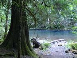
The McKenzie River is a 90 miles (145 km) tributary of the Willamette River
in western Oregon
in the United States
. It drains part of the Cascade Range
east of Eugene
and flows into the southernmost end of the Willamette Valley
. It is named for Donald MacKenzie, a Scottish Canadian
fur trader. There are six large dams on the McKenzie and its tributaries.
in the high Cascades of eastern Linn County
in the Willamette National Forest
. Clear Lake is fed by Ikenick Creek and Fish Lake Creek, the latter of which flows from Fish Lake
(a few miles north of Clear Lake, in Marion County
). Fish Lake's main tributary is Hackieman Creek, which drains the north side of Browder Ridge east of Tombstone Pass. U.S. Route 20
crosses the pass and follows Hackieman Creek. The McKenzie River flows south from Clear Lake, paralleled by Oregon Route 126. It enters Lane County
and flows west past McKenzie Bridge
. It receives the South Fork McKenzie River approximately 3 miles (4.8 km) east of Blue River
. The South Fork rises near the Pacific Crest Trail
in the Three Sisters Wilderness Area
and flows north-northwest approximately 30 miles (48.3 km) through Cougar Reservoir
and Cougar Dam
.
After the South Fork confluence, the main stem McKenzie River flows west through a narrow valley in the mountains, past Vida
and Walterville
. As it emerges from the mountains it passes along the north side of Springfield
and joins the Willamette from the east 5 miles (8 km) north of Eugene.
Fed by numerous other creeks in the Oregon Cascades, the McKenzie Watershed includes the summit of South Sister
, at 10358 feet (3,157.1 m), as well as the McKenzie's confluence with the Willamette, at 375 feet (114.3 m) above sea level. The McKenzie is the sole source of municipal drinking water for Eugene
.
. This flat-bottomed boat with a high bow is used throughout the world for fishing in fast moving rivers.
Willamette River
The Willamette River is a major tributary of the Columbia River, accounting for 12 to 15 percent of the Columbia's flow. The Willamette's main stem is long, lying entirely in northwestern Oregon in the United States...
in western Oregon
Oregon
Oregon is a state in the Pacific Northwest region of the United States. It is located on the Pacific coast, with Washington to the north, California to the south, Nevada on the southeast and Idaho to the east. The Columbia and Snake rivers delineate much of Oregon's northern and eastern...
in the United States
United States
The United States of America is a federal constitutional republic comprising fifty states and a federal district...
. It drains part of the Cascade Range
Cascade Range
The Cascade Range is a major mountain range of western North America, extending from southern British Columbia through Washington and Oregon to Northern California. It includes both non-volcanic mountains, such as the North Cascades, and the notable volcanoes known as the High Cascades...
east of Eugene
Eugene, Oregon
Eugene is the second largest city in the U.S. state of Oregon and the seat of Lane County. It is located at the south end of the Willamette Valley, at the confluence of the McKenzie and Willamette rivers, about east of the Oregon Coast.As of the 2010 U.S...
and flows into the southernmost end of the Willamette Valley
Willamette Valley
The Willamette Valley is the most populated region in the state of Oregon of the United States. Located in the state's northwest, the region is surrounded by tall mountain ranges to the east, west and south and the valley's floor is broad, flat and fertile because of Ice Age conditions...
. It is named for Donald MacKenzie, a Scottish Canadian
Scottish Canadian
Scottish Canadians are people of Scottish descent or heritage living in Canada. As the third-largest ethnic group in Canada and among the first to settle in Canada, Scottish people have made a large impact on Canadian culture since colonial times...
fur trader. There are six large dams on the McKenzie and its tributaries.
Course
The McKenzie River originates as the outflow of Clear LakeClear Lake (Linn County, Oregon)
Clear Lake is a mountain lake 86 mi northeast of Eugene, Oregon, United States in Linn County. It has two main bodies connected by a bottleneck. The lake is primarily fed by snow runoff from nearby Mount Washington and the surrounding areas. The runoff filters through underground caverns for...
in the high Cascades of eastern Linn County
Linn County, Oregon
Linn County is a county located in the U.S. state of Oregon. It is named in honor of Lewis F. Linn, a U.S. Senator from Missouri who advocated the American occupation of the Oregon Country. By the 2010 US census the population of Linn county was 116,672 showing a 13.2% growth since the 2000 census...
in the Willamette National Forest
Willamette National Forest
The Willamette National Forest is a National Forest located in the central portion of the Cascade Range of US state of Oregon.It comprises 1,675,407 acres making it one of the largest national forests. Over 380,000 acres are designated wilderness which include seven major mountain peaks...
. Clear Lake is fed by Ikenick Creek and Fish Lake Creek, the latter of which flows from Fish Lake
Fish Lake (Marion County, Oregon)
Fish Lake is a lake in Marion County, Oregon, United States. Fish Lake lies at an elevation of 4265 feet .-References:*...
(a few miles north of Clear Lake, in Marion County
Marion County, Oregon
Marion County is a county located in the U.S. state of Oregon. It was originally named the Champooick District, after Champoeg, a meeting place on the Willamette River. On September 3, 1849, the territorial legislature renamed it in honor of Francis Marion, a Continental Army general of the...
). Fish Lake's main tributary is Hackieman Creek, which drains the north side of Browder Ridge east of Tombstone Pass. U.S. Route 20
U.S. Route 20
U.S. Route 20 is an east–west United States highway. As the "0" in its route number implies, US 20 is a coast-to-coast route. Spanning , it is the longest road in the United States, and the route sparsely parallels Interstate 90...
crosses the pass and follows Hackieman Creek. The McKenzie River flows south from Clear Lake, paralleled by Oregon Route 126. It enters Lane County
Lane County, Oregon
-National protected areas:*Oregon Islands National Wildlife Refuge *Siuslaw National Forest *Umpqua National Forest *Willamette National Forest -Government:...
and flows west past McKenzie Bridge
McKenzie Bridge, Oregon
McKenzie Bridge is an unincorporated community in Lane County, Oregon, United States, on the McKenzie River and within Willamette National Forest. It is located along Oregon Route 126, about 53 miles east of Eugene, between Rainbow and Belknap Springs...
. It receives the South Fork McKenzie River approximately 3 miles (4.8 km) east of Blue River
Blue River, Oregon
Blue River is an unincorporated community in Lane County, Oregon, United States. It is located on Oregon Route 126 along the McKenzie River, between the communities of Finn Rock and Rainbow. It is in the Willamette National Forest, where the Blue River empties into the McKenzie...
. The South Fork rises near the Pacific Crest Trail
Pacific Crest Trail
The Pacific Crest Trail is a long-distance mountain hiking and equestrian trail on the Western Seaboard of the United States. The southern terminus is at the California border with Mexico...
in the Three Sisters Wilderness Area
Three Sisters Wilderness
The Three Sisters Wilderness is a wilderness area in the Cascade Range, within the Willamette and Deschutes National Forests in Oregon. It comprises 286,708 acres , making it the second largest Wilderness area in Oregon...
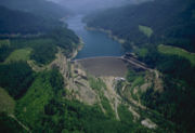
and flows north-northwest approximately 30 miles (48.3 km) through Cougar Reservoir
Cougar Reservoir
Cougar Reservoir is a reservoir on the South Fork McKenzie River in the U.S. state of Oregon. It is located in Lane County. It was created in 1964 with the construction of the hydroelectric Cougar Dam....
and Cougar Dam
Cougar Dam
Cougar Dam is a tall rockfill hydroelectric dam in the U.S. state of Oregon. It has a gated concrete spillway and a powerhouse with two turbines totaling 25 megawatts of electric power....
.
After the South Fork confluence, the main stem McKenzie River flows west through a narrow valley in the mountains, past Vida
Vida, Oregon
Vida is an unincorporated community in Lane County, Oregon, United States. It is located on Oregon Route 126 and the McKenzie River.Vida was originally named "Gate Creek", but this caused confusion with a community of "Gates Creek" in Washington County, so the name of the postmaster's daughter was...
and Walterville
Walterville, Oregon
Walterville is an unincorporated community in Lane County, Oregon, United States. It is located six miles east of Springfield on Oregon Route 126 near the McKenzie River....
. As it emerges from the mountains it passes along the north side of Springfield
Springfield, Oregon
Springfield is a city in Lane County, Oregon, United States. Located in the Southern Willamette Valley, it is within the Eugene-Springfield Metropolitan Statistical Area. Separated from Eugene to the west, mainly by Interstate 5, Springfield is the second-most populous city in the metropolitan area...
and joins the Willamette from the east 5 miles (8 km) north of Eugene.
History
The McKenzie has been home to Native Americans for over 8,000 years. Soon after he had arrived to establish a fur trading post at the mouth of the Columbia River, Donald Mackenzie and others explored the McKenzie and Willamette Rivers in April 1812 as part of an expedition in the Willamette Valley.Watershed
Fed by numerous other creeks in the Oregon Cascades, the McKenzie Watershed includes the summit of South Sister
Three Sisters (Oregon)
The Three Sisters are three volcanic peaks of the Cascade Volcanic Arc and the Cascade Range in Oregon, each of which exceeds in elevation. They are the third, fourth, and fifth highest peaks in the state of Oregon and are located in the Three Sisters Wilderness, about southwest from the nearest...
, at 10358 feet (3,157.1 m), as well as the McKenzie's confluence with the Willamette, at 375 feet (114.3 m) above sea level. The McKenzie is the sole source of municipal drinking water for Eugene
Eugene, Oregon
Eugene is the second largest city in the U.S. state of Oregon and the seat of Lane County. It is located at the south end of the Willamette Valley, at the confluence of the McKenzie and Willamette rivers, about east of the Oregon Coast.As of the 2010 U.S...
.
Drift boat
The McKenzie River is also home of the McKenzie River Drift BoatMcKenzie River dory
The McKenzie dory or Rogue River dory also called by many a Drift Boat is an evolution of the open-water dory, converted for use in rivers. The design is characterized by a wide, flat bottom, flared sides, a narrow, flat bow, and a pointed stern. The sole identifying characteristic of the McKenzie...
. This flat-bottomed boat with a high bow is used throughout the world for fishing in fast moving rivers.
Communities in the McKenzie River Valley
The eastern portion of Oregon Route 126 passes through the valley of the McKenzie River, closely following the river for much of its route. The 60-mile stretch of the river from the edge of the Springfield metro area east to the Cascades is known as the McKenzie Valley. The following communities are located on or near the river and/or the highway in the valley (west to east):- Cedar Flat
- WaltervilleWalterville, OregonWalterville is an unincorporated community in Lane County, Oregon, United States. It is located six miles east of Springfield on Oregon Route 126 near the McKenzie River....
- DeerhornDeerhorn, OregonDeerhorn is an unincorporated community in Lane County, Oregon, United States. It is located about four miles west of Leaburg on Oregon Route 126 in the McKenzie River valley....
- LeaburgLeaburg, OregonLeaburg is an unincorporated community in Lane County, Oregon, United States located on the McKenzie River and Oregon Route 126 east of Walterville and west of Vida.-History:...
- VidaVida, OregonVida is an unincorporated community in Lane County, Oregon, United States. It is located on Oregon Route 126 and the McKenzie River.Vida was originally named "Gate Creek", but this caused confusion with a community of "Gates Creek" in Washington County, so the name of the postmaster's daughter was...
- NimrodNimrod, OregonNimrod is an unincorporated community in Lane County, Oregon, United States, on the McKenzie River. It is located along Oregon Route 126, between Vida and Blue River, 35 miles east of Eugene, in the Willamette National Forest. As of 2003, its population was roughly 190. Nimrod is the site of a...
- Finn RockFinn Rock, OregonFinn Rock is an unincorporated community in Lane County, Oregon, United States. It is located on Oregon Route 126 and the McKenzie River, between the communities of Nimrod and Blue River, in the Willamette National Forest.-Background and history:...
- Blue RiverBlue River, OregonBlue River is an unincorporated community in Lane County, Oregon, United States. It is located on Oregon Route 126 along the McKenzie River, between the communities of Finn Rock and Rainbow. It is in the Willamette National Forest, where the Blue River empties into the McKenzie...
- RainbowRainbow, OregonRainbow is an unincorporated community in Lane County, Oregon, United States. It lies off Oregon Route 126, northeast of Eugene. Rainbow's elevation is . A post office was established on July 1, 1924, and closed August 31, 1937. The post office got its name from the rainbow trout that swim in the...
- McKenzie BridgeMcKenzie Bridge, OregonMcKenzie Bridge is an unincorporated community in Lane County, Oregon, United States, on the McKenzie River and within Willamette National Forest. It is located along Oregon Route 126, about 53 miles east of Eugene, between Rainbow and Belknap Springs...
- Belknap SpringsBelknap Springs, OregonBelknap Springs is an unincorporated community and private hot springs resort in Lane County, Oregon, United States, near the McKenzie River. The springs were located and initially developed by R. S. Belknap in 1869. A post office named "Salt Springs" was established in the location in 1874, and...
See also
- List of rivers of Oregon
- List of longest streams of Oregon