
Fraser River
Encyclopedia
- For other uses of this name see Fraser River (disambiguation)Fraser River (disambiguation)The Fraser River may refer to:*The Fraser River in British Columbia, Canada*The Fraser River, a tributary of the Colorado River in Colorado in the United States.*The Fraser River in Labrador, Canada...
.
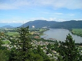
The Fraser River (icon) is the longest river within British Columbia
British Columbia
British Columbia is the westernmost of Canada's provinces and is known for its natural beauty, as reflected in its Latin motto, Splendor sine occasu . Its name was chosen by Queen Victoria in 1858...
, Canada
Canada
Canada is a North American country consisting of ten provinces and three territories. Located in the northern part of the continent, it extends from the Atlantic Ocean in the east to the Pacific Ocean in the west, and northward into the Arctic Ocean...
, rising at Fraser Pass
Fraser Pass
Fraser Pass is a mountain pass in British Columbia's Rockies. Although immediately adjacent to the Continental Divide, the pass does not cross it; rather, it bridges the drainage basins of the Fraser River and Columbia River, both Pacific-draining rivers....
near Mount Robson
Mount Robson
Mount Robson is the most prominent mountain in North America's Rocky Mountain range; it is also the highest point in the Canadian Rockies. The mountain is located entirely within Mount Robson Provincial Park of British Columbia, and is part of the Rainbow Range. It is commonly thought to be the...
in the Rocky Mountains
Rocky Mountains
The Rocky Mountains are a major mountain range in western North America. The Rocky Mountains stretch more than from the northernmost part of British Columbia, in western Canada, to New Mexico, in the southwestern United States...
and flowing for 1375 kilometres (854.4 mi), into the Strait of Georgia
Strait of Georgia
The Strait of Georgia or the Georgia Strait is a strait between Vancouver Island and the mainland coast of British Columbia, Canada. It is approximately long and varies in width from...
at the city of Vancouver
Vancouver
Vancouver is a coastal seaport city on the mainland of British Columbia, Canada. It is the hub of Greater Vancouver, which, with over 2.3 million residents, is the third most populous metropolitan area in the country,...
. It is the tenth longest river in Canada. The river's annual discharge at its mouth is 112 km3 (27 cubic miles or 3550 m3/s), and it discharges 20 million tons of sediment into the ocean. The river is named for Simon Fraser
Simon Fraser (explorer)
Simon Fraser was a fur trader and an explorer who charted much of what is now the Canadian province of British Columbia. Fraser was employed by the Montreal-based North West Company. By 1805, he had been put in charge of all the company's operations west of the Rocky Mountains...
, who led an expedition on behalf of the North West Company
North West Company
The North West Company was a fur trading business headquartered in Montreal from 1779 to 1821. It competed with increasing success against the Hudson's Bay Company in what was to become Western Canada...
from the site of present-day Prince George
Prince George, British Columbia
Prince George, with a population of 71,030 , is the largest city in northern British Columbia, Canada, and is known as "BC's Northern Capital"...
to the mouth of the river.
Geography
The Fraser drains a 220,000 km² (85,000 sq mi) area. Its source is a dripping spring at Fraser PassFraser Pass
Fraser Pass is a mountain pass in British Columbia's Rockies. Although immediately adjacent to the Continental Divide, the pass does not cross it; rather, it bridges the drainage basins of the Fraser River and Columbia River, both Pacific-draining rivers....
. The river then flows north to the Yellowhead Highway and west past Mount Robson
Mount Robson
Mount Robson is the most prominent mountain in North America's Rocky Mountain range; it is also the highest point in the Canadian Rockies. The mountain is located entirely within Mount Robson Provincial Park of British Columbia, and is part of the Rainbow Range. It is commonly thought to be the...
to the Rocky Mountain Trench
Rocky Mountain Trench
The Rocky Mountain Trench, or the Trench or The Valley of a Thousand Peaks, is a large valley in the northern part of the Rocky Mountains. It is both visually and cartographically a striking physiographic feature extending approximately from Flathead Lake, Montana, to the Liard River, just south...
and the Robson Valley
Robson Valley
The Robson Valley is a geographic region of the Canadian province of British Columbia, comprising the section of the Rocky Mountain Trench that lies southeast of the city of Prince George following the Fraser River to the Yellowhead Pass. The name is derived from Mount Robson, which stands near...
near Valemount
Valemount, British Columbia
Valemount is a village of 1,018 people in east central British Columbia, Canada. It is situated between the Rocky, Monashee, and Cariboo Mountains. It is the nearest community to the west of Jasper National Park, and is also the nearest community to Mount Robson Provincial Park, which features...
. After running northwest past 54° north, it makes a sharp turn to the south at Giscome Portage
Giscome Portage
The Giscome Portage was a portage between the Fraser River and Summit Lake in British Columbia, Canada. The south end of the portage is now the location of a heritage site, the Huble Homestead, which is located on the Fraser River, 40 km north of Prince George and 6 km off Highway...
, meeting the Nechako River
Nechako River
The Nechako River arises on the Nechako Plateau east of the Kitimat Ranges of the Coast Mountains of British Columbia and flows north toward Fort Fraser, then east to Prince George where it enters the Fraser River...
at the city of Prince George, then continuing south, progressively cutting deeper and deeper into the Fraser Plateau
Fraser Plateau
The Fraser Plateau is an intermontane plateau. It is one of the main subdivisions of the Interior Plateau located in the Central Interior of British Columbia, and includes the Cariboo and Chilcotin Plateaus and the adjoining Marble, Clear and Camelsfoot Ranges on its southwestern edge...
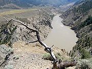
to form the Fraser Canyon
Fraser Canyon
The Fraser Canyon is an 84 km landform of the Fraser River where it descends rapidly through narrow rock gorges in the Coast Mountains en route from the Interior Plateau of British Columbia to the Fraser Valley...
from roughly the confluence of the Chilcotin River
Chilcotin River
The Chilcotin River is a long tributary of the Fraser River in southern British Columbia, Canada. It drains the Chilcotin Plateau, which lies between the Fraser River and the Coast Mountains...
, near the city of Williams Lake
Williams Lake, British Columbia
Williams Lake, is a city in the Central Interior of British Columbia, Canada. Located in the central part of a region known as the Cariboo, it is the largest urban centre between Kamloops and Prince George, with a population of 11,150 in city limits....
, southwards. It is joined by the Bridge
Bridge River
The Bridge River is, or was, a major tributary of British Columbia's Fraser River, entering that stream about six miles upstream from the town of Lillooet.-Name:Its name in the Lillooet language is Xwisten , sometimes spelled Nxwisten or Nxo-isten)...
and Seton River
Seton River
The Seton River is a tributary of the Fraser River in the Canadian province of British Columbia.-Course:The Seton River originates at the foot of Anderson Lake and runs initially for only 3km to the head of Seton Lake...
s at the town of Lillooet
Lillooet, British Columbia
Lillooet is a community on the Fraser River in western Canada, about up the British Columbia Railway line from Vancouver. Situated at an intersection of deep gorges in the lee of the Coast Mountains, it has a dry climate- of precipitation is recorded annually at the town's weather station,...
, then by the Thompson River
Thompson River
The Thompson River is the largest tributary of the Fraser River, flowing through the south-central portion of British Columbia, Canada. The Thompson River has two main branches called the South Thompson and the North Thompson...
at Lytton
Lytton, British Columbia
Lytton in British Columbia, Canada, sits at the confluence of the Thompson River and Fraser River on the east side of the Fraser. The location has been inhabited by the Nlaka'pamux people for over 10,000 years, and is one of the earliest locations settled by non-natives in the Southern Interior of...
, where it proceeds south until it is approximately 40 miles (64.4 km) north of the 49th parallel
49th parallel north
The 49th parallel north is a circle of latitude that is 49 degrees north of the Earth's equatorial plane. It crosses Europe, Asia, the Pacific Ocean, North America, and the Atlantic Ocean....
, which is Canada's border with the United States
United States
The United States of America is a federal constitutional republic comprising fifty states and a federal district...
.
From Lytton southwards it runs through a progressively deeper canyon between the Lillooet Ranges
Lillooet Ranges
The Lillooet Ranges are the southeasternmost subdivision of the Pacific Ranges of the Coast Mountains of British Columbia. They are located between the drainage of the Lillooet River and Harrison Lake on the west and the canyon of the Fraser River on the east, and by the lowland coastal valley of...
of the Coast Mountains
Coast Mountains
The Coast Mountains are a major mountain range, in the Pacific Coast Ranges, of western North America, extending from southwestern Yukon through the Alaska Panhandle and virtually all of the Coast of British Columbia. They are so-named because of their proximity to the sea coast, and are often...
on its west and the Cascade Mountains on its east. At Yale
Yale, British Columbia
Yale is an unincorporated town in the Canadian province of British Columbia. It was founded in 1848 by the Hudson's Bay Company as Fort Yale by Ovid Allard, the appointed manager of the new post, who named it after his superior, James Murray Yale, then Chief Factor of the Columbia District...
, at the head of navigation on the river, the canyon opens up and the river is wider, though without much adjoining lowland until Hope
Hope, British Columbia
Hope is a district municipality located at the confluence of the Fraser and Coquihalla rivers in the province of British Columbia, Canada. Hope is at the eastern end of both the Fraser Valley and the Lower Mainland region, and is at the southern end of the Fraser Canyon...
, where the river then turns west and southwest into a lush lowland valley, known as the Fraser Valley
Fraser Valley
The Fraser Valley is the section of the Fraser River basin in southwestern British Columbia downstream of the Fraser Canyon. The term is sometimes used to refer to the Fraser Canyon and stretches upstream from there, but in general British Columbian usage of the term refers to the stretch of the...
, past Chilliwack
Chilliwack, British Columbia
Chilliwack is a Canadian city in the Province of British Columbia. It is a predominantly agricultural community with an estimated population of 80,000 people. Chilliwack is the second largest city in the Fraser Valley Regional District after Abbotsford. The city is surrounded by mountains and...
and the confluence of the Harrison
Harrison River
The Harrison River is a short but large tributary of the Fraser River, entering it near the community of Chehalis, British Columbia. The Harrison drains Harrison Lake and is the de facto continuation of the Lillooet River, which feeds the lake....
and Sumas River
Sumas River
The Sumas River is a tributary of the Fraser River in the Canadian province of British Columbia and the U.S. state of Washington.-Course:The Sumas River originates in Whatcom County, Washington just north of the Nooksack River and west of Sumas Mountain...
s, bending northwest at Abbotsford
Abbotsford, British Columbia
Abbotsford is a Canadian city located in the Lower Mainland of British Columbia, adjacent to Greater Vancouver. It is the fifth largest municipality in British Columbia, home to 123,864 people . Its Census Metropolitan Area, which includes the District of Mission, is the 23rd largest in Canada,...
and Mission
Mission, British Columbia
Mission, the core of which was formerly known as Mission City, is a district municipality in the province of British Columbia, Canada. It is situated on the north bank of the Fraser River overlooking the City of Abbotsford and with that city is part of the Central Fraser Valley. Mission is the...
, turning southwest again just east of New Westminster, where it splits into a North Arm, which is the southern boundary of the city of Vancouver, and the South Arm, which divides the City of Richmond
Richmond, British Columbia
Richmond is a coastal city, incorporated in the Canadian province of British Columbia. Part of Metro Vancouver, its neighbouring communities are Vancouver and Burnaby to the north, New Westminster to the east, and Delta to the south, while the Strait of Georgia forms its western border...
from the Corporation of Delta.
Richmond is on the largest island in the Fraser, Lulu Island
Lulu Island
Lulu Island is the name of the largest island in the estuary of the Fraser River. The island makes up most of the City of Richmond, a major suburb of Vancouver, British Columbia...
and also on Sea Island
Sea Island
Sea Island may refer to:*Sea Island , an island in Richmond, British Columbia that contains the Vancouver International Airport*Sea Island, Georgia, an isolated resort island in Glynn County, Georgia...
, which is the location of Vancouver Airport; the eastern end of Lulu Island is within the City of New Westminster and is called Queensborough
Queensborough, British Columbia
Queensborough is a neighbourhood in the city of New Westminster, British Columbia, Canada. It is on the eastern tip of Lulu Island on the Fraser River.-History:...
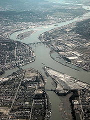
. Also in the lowermost Fraser, among other smaller islands, is Annacis Island
Annacis Island
Annacis Island is an island located in the South Arm of the Fraser River in Delta, British Columbia, Canada. The island is now mostly industrial, and it contains one of the Metro Vancouver's secondary wastewater treatment plants...
, an important industrial and port area, which lies to the southeast of the eastern end of Lulu Island (Sea, Lulu and Annacis Islands lie between the North and South Arms. Other notable islands in the lower Fraser are Barnston Island, Matsqui Island
Matsqui Island
Matsqui Island is a large island in the Fraser River in the Central Fraser Valley region of British Columbia, Canada, located between the City of Abbotsford and the District of Mission and about a mile downstream from the Mission Bridge...
, Nicomen Island
Nicomen Island
Nicomen Island is an island in the Fraser River east of Mission and between Deroche and Dewdney . Located on the river's north side, and separated from the foot of the Douglas Ranges by Nicomen Slough, the island is near-totally given over to agriculture and constitutes a rural community in its...
and Sea Bird Island
Sea Bird Island (British Columbia)
Sea Bird Island is an island in the Fraser River just east of Agassiz, British Columbia, Canada, in the Upper Fraser Valley region of that province, about 75 miles east of Vancouver...
.` Other islands lie on the outer side of the estuary, most notably Westham Island
Westham Island
Westham Island is an island located near Ladner, British Columbia, Canada. The island is accessible via the Westham Island Bridge. The George C. Reifel Refuge for migratory birds is located at the northern end of the island. The Alaksen National Wildlife Area is also located on the...
, a wildfowl preserve, and Iona Island, the location of the main sewage plant for the City of Vancouver.
After 100 kilometres (about 60 mi), it forms a delta
River delta
A delta is a landform that is formed at the mouth of a river where that river flows into an ocean, sea, estuary, lake, reservoir, flat arid area, or another river. Deltas are formed from the deposition of the sediment carried by the river as the flow leaves the mouth of the river...
where it empties into the Strait of Georgia
Strait of Georgia
The Strait of Georgia or the Georgia Strait is a strait between Vancouver Island and the mainland coast of British Columbia, Canada. It is approximately long and varies in width from...
between the mainland and Vancouver Island
Vancouver Island
Vancouver Island is a large island in British Columbia, Canada. It is one of several North American locations named after George Vancouver, the British Royal Navy officer who explored the Pacific Northwest coast of North America between 1791 and 1794...
. The lands south of the City of Vancouver, including the cities of Richmond
Richmond, British Columbia
Richmond is a coastal city, incorporated in the Canadian province of British Columbia. Part of Metro Vancouver, its neighbouring communities are Vancouver and Burnaby to the north, New Westminster to the east, and Delta to the south, while the Strait of Georgia forms its western border...
and Delta
Delta, British Columbia
Delta is a district municipality in British Columbia, and forms part of Metro Vancouver. Located south of Richmond, it is bordered by the Fraser River to the north, the United States to the south and the city of Surrey to the east...
, sit on the flat flood plain. The islands of the delta include Iona Island
Iona Island, British Columbia
Iona Island in Richmond, British Columbia, Canada was formerly an island, but is now a peninsula physically connected to Sea Island via a causeway...
, Sea Island
Sea Island, British Columbia
Sea Island is located in the city of Richmond, British Columbia, directly across the river from Vancouver and fifteen kilometres from Vancouver's downtown core. The island is in the estuary of the Fraser River, giving it a unique ecological environment...
, Lulu Island
Lulu Island
Lulu Island is the name of the largest island in the estuary of the Fraser River. The island makes up most of the City of Richmond, a major suburb of Vancouver, British Columbia...
, Annacis Island
Annacis Island
Annacis Island is an island located in the South Arm of the Fraser River in Delta, British Columbia, Canada. The island is now mostly industrial, and it contains one of the Metro Vancouver's secondary wastewater treatment plants...
, and a number of smaller islands. While the vast majority of the river's drainage basin
Drainage basin
A drainage basin is an extent or an area of land where surface water from rain and melting snow or ice converges to a single point, usually the exit of the basin, where the waters join another waterbody, such as a river, lake, reservoir, estuary, wetland, sea, or ocean...
lies within British Columbia, a small portion in the drainage basin lies across the international border in Washington in the United States, namely the upper reaches of the tributary Chilliwack
Vedder River
The Vedder River, called the Chilliwack River above Vedder Crossing, is a river in the Canadian province of British Columbia and the U.S. state of Washington....
and Sumas River
Sumas River
The Sumas River is a tributary of the Fraser River in the Canadian province of British Columbia and the U.S. state of Washington.-Course:The Sumas River originates in Whatcom County, Washington just north of the Nooksack River and west of Sumas Mountain...
s. Most of lowland Whatcom County, Washington
Whatcom County, Washington
Whatcom County is a county located in the U.S. state of Washington. Its name ultimately derives from the Lummi word Xwotʼqom, meaning "noisy water." As of 2010, the population was 201,140. The county seat is at Bellingham, which is also the county's largest city...
is part of the Fraser Lowland
Fraser Lowland
The Fraser Lowland is a landform and physiographic region of the Pacific Northwest, in the Canadian province of British Columbia and the U.S. state of Washington. It includes much of the Lower Mainland region of British Columbia and a portion of Whatcom County, south of the Canada–US border...
and was formed also by sediment deposited from the Fraser, though most of the county is not in the Fraser drainage basin.
Similar to the Columbia River Gorge
Columbia River Gorge
The Columbia River Gorge is a canyon of the Columbia River in the Pacific Northwest of the United States. Up to deep, the canyon stretches for over as the river winds westward through the Cascade Range forming the boundary between the State of Washington to the north and Oregon to the south...
east of Portland, Oregon
Portland, Oregon
Portland is a city located in the Pacific Northwest, near the confluence of the Willamette and Columbia rivers in the U.S. state of Oregon. As of the 2010 Census, it had a population of 583,776, making it the 29th most populous city in the United States...
, the Fraser exploits a topographic cleft between two mountain ranges separating a more continental climate (in this case, that of the British Columbia Interior
British Columbia Interior
The British Columbia Interior or BC Interior or Interior of British Columbia, usually referred to only as the Interior, is one of the three main regions of the Canadian province of British Columbia, the other two being the Lower Mainland, which comprises the overlapping areas of Greater Vancouver...
) from a milder climate near the coast. When an Arctic high-pressure area moves into the British Columbia Interior and a relatively low-pressure area builds over the general Puget Sound
Puget Sound
Puget Sound is a sound in the U.S. state of Washington. It is a complex estuarine system of interconnected marine waterways and basins, with one major and one minor connection to the Strait of Juan de Fuca and the Pacific Ocean — Admiralty Inlet being the major connection and...
and Strait of Georgia
Strait of Georgia
The Strait of Georgia or the Georgia Strait is a strait between Vancouver Island and the mainland coast of British Columbia, Canada. It is approximately long and varies in width from...
region, the cold Arctic air accelerates southwest through the Fraser Canyon
Fraser Canyon
The Fraser Canyon is an 84 km landform of the Fraser River where it descends rapidly through narrow rock gorges in the Coast Mountains en route from the Interior Plateau of British Columbia to the Fraser Valley...
. These outflow winds can gust up to 60 to 80 mph (26.8 to 35.8 ) and have at times exceeded 100 miles per hour (44.7 m/s). Such winds frequently reach Bellingham
Bellingham, Washington
Bellingham is the largest city in, and the county seat of, Whatcom County in the U.S. state of Washington. It is the twelfth-largest city in the state. Situated on Bellingham Bay, Bellingham is protected by Lummi Island, Portage Island, and the Lummi Peninsula, and opens onto the Strait of Georgia...
and the San Juan Islands
San Juan Islands
The San Juan Islands are an archipelago in the northwest corner of the contiguous United States between the US mainland and Vancouver Island, British Columbia, Canada. The San Juan Islands are part of the U.S...
, gaining strength over the open water of the Strait of Juan de Fuca
Strait of Juan de Fuca
The Strait of Juan de Fuca is a large body of water about long that is the Salish Sea outlet to the Pacific Ocean...
.
The estuary at the river's mouth is a site of hemispheric importance in the Western Hemisphere Shorebird Reserve Network
Western Hemisphere Shorebird Reserve Network
The Western Hemisphere Shorebird Reserve Network is a conservation strategy targeting shorebirds in the Americas launched in 1985. Its aim is to protect the nesting, breeding and staging habitats of migratory shorebirds...
.
Discharge
With an average flow at the mouth of about 3475 m3/s, the Fraser is the largest river by volume flowing into the Pacific seaboard of Canada and the fifth largest in the country. The average flow is highly seasonal; summer discharge rates can be ten times larger than the flow during the winter.The Fraser's highest recorded flow, in June 1894, is estimated to have been 17000 m3/s at Hope
Hope, British Columbia
Hope is a district municipality located at the confluence of the Fraser and Coquihalla rivers in the province of British Columbia, Canada. Hope is at the eastern end of both the Fraser Valley and the Lower Mainland region, and is at the southern end of the Fraser Canyon...
. It was calculated using high water marks near the hydrometric station at Hope and various statistical methods. In 1958 the Fraser River Board adopted the estimate for the 1894 flood. It remains the value specified by regulatory agencies for all flood control work on the river. Further studies and hydraulic models have estimated the maximum discharge of the Fraser River, at Hope during the 1894 flood, as within a range of about 16000 m3/s.
History
On June 14, 1792, the Spanish explorers Dionisio Alcalá GalianoDionisio Alcalá Galiano
Dionisio Alcalá Galiano was a Spanish naval officer, cartographer, and explorer. He mapped various coastlines in Europe and the Americas with unprecedented accuracy, using new technology such as chronometers...
and Cayetano Valdés
Cayetano Valdés y Flores
Cayetano Valdés y Flores Bazán was a commander of the Spanish Navy, explorer, and captain general who served in the French Revolutionary and Napoleonic Wars, fighting for both sides at different times due to the changing fortunes of Spain in the conflict...
entered and anchored in the north arm of the Fraser River, becoming the first Europeans to find and enter it. The existence of the river, but not its location, had been deduced during the 1791 voyage of José María Narváez
José María Narváez
José María Narváez was a Spanish naval officer, explorer, and navigator notable for his work in the Pacific Northwest of present-day Canada. In 1791, as commander of the schooner Santa Saturnina, he led the first European exploration of the Strait of Georgia, including a landing on present-day...
, under Francisco de Eliza
Francisco de Eliza
Francisco de Eliza y Reventa was a Spanish naval officer, navigator, and explorer. He is remembered mainly for his work in the Pacific Northwest...
.
The upper reaches of the Fraser River were first explored by Sir Alexander Mackenzie in 1793, and fully traced by Simon Fraser in 1808, who confirmed that it was not connected with the Columbia River
Columbia River
The Columbia River is the largest river in the Pacific Northwest region of North America. The river rises in the Rocky Mountains of British Columbia, Canada, flows northwest and then south into the U.S. state of Washington, then turns west to form most of the border between Washington and the state...
.
In 1828 George Simpson
George Simpson (administrator)
Sir George Simpson was a Scots-Quebecer and employee of the Hudson's Bay Company . His title was Governor-in-Chief of Rupert's Land and administrator over the Northwest Territories and Columbia Department in British North America from 1821 to 1860.-Early years:George Simpson was born in Dingwall,...
visited the river, mainly to examine Fort Langley
Fort Langley National Historic Site
Fort Langley is a former trading post of the Hudson's Bay Company, now located in the village of Fort Langley, British Columbia. Commonly referred to as "the birthplace of British Columbia", it is designated a National Historic Site of Canada and administered by Parks Canada.-A new fort:After John...
and determine whether it would be suitable as the company's main Pacific depot. Simpson had believed the Fraser River might be navigable throughout its length, even though Simon Fraser had described it as non-navigable. Simpson journeyed down the river and through the Fraser Canyon
Fraser Canyon
The Fraser Canyon is an 84 km landform of the Fraser River where it descends rapidly through narrow rock gorges in the Coast Mountains en route from the Interior Plateau of British Columbia to the Fraser Valley...
and afterwords wrote "I should consider the passage down, to be certain Death, in nine attempts out of Ten. I shall therefore no longer talk about it as a navigable stream". His trip down the river convinced him that Fort Langley could not replace Fort Vancouver
Fort Vancouver
Fort Vancouver was a 19th century fur trading outpost along the Columbia River that served as the headquarters of the Hudson's Bay Company in the company's Columbia District...
as the company's main depot on the Pacific coast.
Much of British Columbia's history has been bound to the Fraser, partly because it was the essential route between the Interior and the Lower Coast after the loss of the lands south of the 49th Parallel with the Oregon Treaty
Oregon Treaty
The Oregon Treaty is a treaty between the United Kingdom and the United States that was signed on June 15, 1846, in Washington, D.C. The treaty brought an end to the Oregon boundary dispute by settling competing American and British claims to the Oregon Country, which had been jointly occupied by...
of 1846. It was the site of its first recorded settlements of Aboriginal people (see Musqueam, Stó:lō
Stó:lo
The Sto:lo , alternately written as Stó:lō, Stó:lô or Stó:lõ and historically as Staulo or Stahlo, and historically known and commonly referred to in ethnographic literature as the Fraser River Indians or Lower Fraser Salish, are a group of First Nations peoples inhabiting the Fraser Valley of...
, St'at'imc
St'at'imc
The St'át'imc are an Interior Salish people located in the southern Coast Mountains and Fraser Canyon region of the Interior of the Canadian province of British Columbia.St'át'imc culture displayed many features typical of Northwest Coast peoples: the...
, Secwepemc
Secwepemc
The Secwepemc , known in English as the Shuswap people, are a First Nations people residing in the Canadian province of British Columbia. Their traditional territory ranges from the eastern Chilcotin Plateau and the Cariboo Plateau southeast through the Thompson Country to Kamloops and the Shuswap...
and Nlaka'pamux
Nlaka'pamux
The Nlaka'pamux , commonly called "the Thompson", and also Thompson River Salish, Thompson Salish, Thompson River Indians or Thompson River people) are an indigenous First Nations/Native American people of the Interior Salish language group in southern British Columbia...
), the route of multitudes of prospectors during the Fraser Canyon Gold Rush
Fraser Canyon Gold Rush
The Fraser Canyon Gold Rush, began in 1858 after gold was discovered on the Thompson River in British Columbia at its confluence with the Nicoamen River. This was a few miles upstream from the Thompson's confluence with the Fraser River at present-day Lytton...
and the main vehicle of the province's early commerce and industry.
This river has been designated a Canadian Heritage River
Canadian Heritage Rivers System
The Canadian Heritage Rivers System was established in 1984 by the federal, provincial and territorial governments to conserve and protect the best examples of Canada's river heritage, to give them national recognition, and to encourage the public to enjoy and appreciate them. It is a cooperative...
for its natural and human heritage.
Uses
Pulp mill
A pulp mill is a manufacturing facility that converts wood chips or other plant fibre source into a thick fibre board which can be shipped to a paper mill for further processing. Pulp can be manufactured using mechanical, semi-chemical or fully chemical methods...
s, and a few dams on some tributaries provide hydroelectric power. The main flow of the Fraser has never been dammed partly because its high level of sediment flows would result in a short dam lifespan, but mostly because of strong opposition from fisheries and other environmental concerns. In 1858, the Fraser River and surrounding areas were occupied when the gold rush came to the Fraser Canyon and the Fraser River.
The delta
River delta
A delta is a landform that is formed at the mouth of a river where that river flows into an ocean, sea, estuary, lake, reservoir, flat arid area, or another river. Deltas are formed from the deposition of the sediment carried by the river as the flow leaves the mouth of the river...
of the river, especially in the Boundary Bay
Boundary Bay
Boundary Bay is situated on the Pacific coast of North America on the border between the Canadian province of British Columbia and the U.S. state of Washington....
area, is an important stopover location for migrating
Bird migration
Bird migration is the regular seasonal journey undertaken by many species of birds. Bird movements include those made in response to changes in food availability, habitat or weather. Sometimes, journeys are not termed "true migration" because they are irregular or in only one direction...
shorebirds
The Fraser Herald
Fraser Herald
Fraser Herald of Arms is the title of one of the officers of arms at the Canadian Heraldic Authority in Ottawa. Like the other heralds at the Authority, the name is derived from the Canadian river of the same name. Since the inception of the office, Fraser Herald of Arms has been the principal...
, a regional position within the Canadian Heraldic Authority
Canadian Heraldic Authority
The Canadian Heraldic Authority is part of the Canadian honours system under the Queen of Canada, whose authority is exercised by the Governor General. The Authority is responsible for the creation and granting of new coats of arms , flags and badges for Canadian citizens, permanent residents and...
is named after the river.
Flooding
After European settlement, the first disastrous flood in the Fraser Valley occurred in 1894. With no protection against the rising waters of the Fraser River, Fraser Valley communities from Chilliwack downstream were inundated with water. In the 1894 floods, the water mark at Mission reached 25.75 ft (7.8 m).After the 1894 flood, a dyking system was constructed throughout the Fraser Valley. The dyking and drainage projects greatly improved the flood problems, but unfortunately over time, the dykes were allowed to fall into disrepair and became overgrown with brush and trees. With some dykes constructed of a wooden frame, they gave way in 1948 in several locations, marking the second disastrous flood. Flooding since 1948 has been minor in comparison.
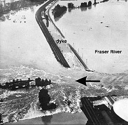
1948 flood
1948 saw massive flooding in Chilliwack and other areas along the Fraser River. The high water mark at Mission rose to 24.7 ft (7.5 m).Timeline
- Throughout the May 24 long weekend, the waters of the Fraser were rising steadily, but only a few thought any real danger lay ahead.
- On May 28, 1948, the Semiault Creek Dyke broke.
- On May 29, 1948, dykes near Glendale (now Cottonwood Corners) gave way and in four days, 12000 acres (48.6 km²) of fertile ground were under water.
- On June 1, 1948, the Cannor Dyke (east of Vedder Canal near Trans Canada Highway) broke and released tons of Fraser River water onto the Greendale area, destroying homes and fields.
- On June 3, 1948, the steamer Gladys supplied flood-stricken Chilliwack with tents and provisions as well as moving people and stock onto high ground.
Reasons for the flood of 1948
Cool temperatures during March, April and early May had delayed the melting of the heavy snowpack that had accumulated over the winter season. Several days of hot weather and warm rains over the holiday weekend in late May hastened the thawing of the snowpack. Rivers and streams quickly swelled with spring runoff, reaching heights surpassed only in 1894. Finally, the poorly-maintained dike systems failed to contain the water.At the height of the 1948 flood, 50000 acres (202.3 km²) stood under water. Dykes broke at Agassiz, Chiliwack, Nicomen Island, Glen Valley and Matsqui. By the time the flood waters receded a month later, 16,000 people had been evacuated, damages totaled $20 million.
Later Flooding
Due to record snowpacks on the mountains in the Fraser River catch basin which began melting, combined with heavy rainfall, water levels on the Fraser River rose in 2007 to a level not reached since 1972. Low-lying land in areas upriver such as Prince GeorgePrince George, British Columbia
Prince George, with a population of 71,030 , is the largest city in northern British Columbia, Canada, and is known as "BC's Northern Capital"...
suffered minor flooding. Evacuation alerts were given for the low-lying areas not protected by dikes in the Lower Mainland
Lower Mainland
The Lower Mainland is a name commonly applied to the region surrounding and including Vancouver, British Columbia, Canada. As of 2007, 2,524,113 people live in the region; sixteen of the province's thirty most populous municipalities are located there.While the term Lower Mainland has been...
. However, the water levels did not breach the dikes, and major flooding was averted.
Tributaries (listed from the mouth up)
- Brunette RiverBrunette RiverThe Brunette River runs through East Burnaby and Coquitlam, flowing out of Burnaby Lake and to the Fraser River. According to a map and materials by Heritage Advisory Committee and Environment and Waste Management Committee of the City of Burnaby , the number of native campsites discovered on the...
- Coquitlam RiverCoquitlam RiverThe Coquitlam River is located in between the cities of Coquitlam and Port Coquitlam, suburban municipalities located in the Metro Vancouver. This river is a tributary for the Fraser River. Each year hundreds of salmon return to spawn in the Coquitlam River. There is a reservoir near the...
- Pitt RiverPitt RiverThe Pitt River in British Columbia, Canada is a large tributary of the Fraser River, entering it a few miles upstream from New Westminster and about 25 km ESE of Downtown Vancouver. The river, which begins in the Garibaldi Ranges of the Coast Mountains, is in two sections above and below Pitt...
- Stave RiverStave RiverThe Stave River is a tributary of the Fraser, joining it at the boundary between the municipalities of Maple Ridge and Mission, about 35 km east of Vancouver, British Columbia, Canada, in the Central Fraser Valley region....
- D'Herbomez CreekD'Herbomez CreekD'Herbomez Creek is a creek in eastern Mission, British Columbia, flowing southeast to join the Fraser River at the Pekw'Xe:yles Indian Reserve D'Herbomez Creek is a creek in eastern Mission, British Columbia, flowing southeast to join the Fraser River at the Pekw'Xe:yles Indian Reserve D'Herbomez...
- Norrish CreekNorrish CreekNorrish Creek is a tributary of the Fraser River. It is located in the Coast Mountains of British Columbia, Canada.- Course :Norrish Creek has its source in Dickson Lake, a medium sized, seldom visited reservoir at the bases of Mount Wardrop and Catherwood. The creek flows alongside Norrish Creek...
- Sumas RiverSumas RiverThe Sumas River is a tributary of the Fraser River in the Canadian province of British Columbia and the U.S. state of Washington.-Course:The Sumas River originates in Whatcom County, Washington just north of the Nooksack River and west of Sumas Mountain...
- Harrison RiverHarrison RiverThe Harrison River is a short but large tributary of the Fraser River, entering it near the community of Chehalis, British Columbia. The Harrison drains Harrison Lake and is the de facto continuation of the Lillooet River, which feeds the lake....
- Ruby Creek
- Coquihalla RiverCoquihalla RiverThe Coquihalla River is located in the Cascade Mountains near the town of Hope, British Columbia. It originates in the Coquihalla Lakes and empties into the Fraser River at Hope....
- Anderson RiverAnderson River (British Columbia)The Anderson River is a tributary of the Fraser River in the Canadian province of British Columbia.The river is presumably named after Alexander Caulfield Anderson of the Hudson's Bay Company who traveled through the region in 1847-48.-Course:...
- Nahatlatch RiverNahatlatch RiverThe Nahatlatch River is a tributary of the Fraser River in the Canadian province of British Columbia.-Course:The Nahatlatch River originates in the Coast Mountains and flows generally east to join the Fraser River north of Boston Bar....
- Thompson RiverThompson RiverThe Thompson River is the largest tributary of the Fraser River, flowing through the south-central portion of British Columbia, Canada. The Thompson River has two main branches called the South Thompson and the North Thompson...
- Stein RiverStein RiverThe Stein River is a tributary of the Fraser River in the Canadian province of British Columbia.The name is derived from the Nlaka'pamux word Stagyn, meaning "hidden place", referring to the fact that the size and extent of the Stein River valley is not very noticeable from the river's confluence...
- Seton RiverSeton RiverThe Seton River is a tributary of the Fraser River in the Canadian province of British Columbia.-Course:The Seton River originates at the foot of Anderson Lake and runs initially for only 3km to the head of Seton Lake...
- Bridge RiverBridge RiverThe Bridge River is, or was, a major tributary of British Columbia's Fraser River, entering that stream about six miles upstream from the town of Lillooet.-Name:Its name in the Lillooet language is Xwisten , sometimes spelled Nxwisten or Nxo-isten)...
- Churn CreekChurn CreekChurn Creek is a tributary of the Fraser River in the Canadian province of British Columbia.-Course:Churn Creek flows generally northeast, joining the Fraser River just south of the headquarters of the Gang Ranch and opposite the community of Dog Creek and associated creek...
- Chilcotin RiverChilcotin RiverThe Chilcotin River is a long tributary of the Fraser River in southern British Columbia, Canada. It drains the Chilcotin Plateau, which lies between the Fraser River and the Coast Mountains...
- Williams Lake RiverWilliams Lake RiverWilliams Lake River is a tributary of the Fraser River in the Canadian province of British Columbia.-Course:Williams Lake River originates in Williams Lake, whose main tributary is the San Jose River. From Williams Lake the Williams Lake River flows a short distance west to join the Fraser River....
- Quesnel RiverQuesnel RiverThe Quesnel River is a major tributary of the Fraser River in the Cariboo District of central British Columbia. It begins at the outflow of Quesnel Lake, at the town of Likely and flows for about northwest to its confluence with the Fraser at the city of Quesnel.- History :Just downstream from...
- Cottonwood River
- West Road RiverWest Road RiverThe West Road River or Blackwater River is a major tributary of the Fraser River, flowing generally north-eastward from the northern slopes of the Ilgachuz Range and across the Fraser Plateau in the Chilcotin region of central British Columbia, Canada...
(Blackwater River) - Nechako RiverNechako RiverThe Nechako River arises on the Nechako Plateau east of the Kitimat Ranges of the Coast Mountains of British Columbia and flows north toward Fort Fraser, then east to Prince George where it enters the Fraser River...
- Salmon RiverSalmon River (Fraser River)The Salmon River is a tributary of the Fraser River in the Central Interior of British Columbia, Canada, flowing southeast to meet that river to the west of Eaglet Lake, to the north of the city of Prince George. The community of Salmon Valley is located in its basin.The nearby McGregor River was...
- Willow RiverWillow River (British Columbia)The Willow River is a tributary of the Fraser River in the north-central Interior of British Columbia, Canada. It enters the Fraser at the community of Willow River, just upstream from the city of Prince George, near the confluence of the McGregor River...
- McGregor RiverMcGregor RiverThe McGregor River is a tributary of the Fraser River in the Canadian province of British Columbia.The river is named in honor of Captain James Herrick McGregor who fought and died in 1915 at the Second Battle of Ypres, in Belgian Flanders.-Course:...
- Bowron RiverBowron RiverThe Bowron River, also formerly named the Bear River and Reid Creek, originates in Bowron Lake Provincial Park of east central British Columbia and flows northwest from the outlet of the Bowron Lakes, then northeast, to join the Fraser River...
- Torpy RiverTorpy RiverThe Torpy River is a tributary of the Fraser River, rising in the Northern Rockies and the McGregor Range, a subdivision of the McGregor Plateau, and forming the boundary between the Rockies and the McGregor Plateau....
- Morkill River
- Goat River
- Doré RiverDoré River (Fraser)The Doré River is a tributary of the Fraser River in the Canadian province of British Columbia.According to a trapper named Jack Damon, the river was originally called Fifty Mile Creek and was given the name doré, French for "golden", by a Norwegian prospector named Olson.Creek-Course:The Doré...
- Holmes RiverHolmes RiverThe Holmes River is a tributary of the upper Fraser River in the Robson Valley region of British Columbia, Canada, entering that river southeast of the village of McBride.-References:***-External links:*...
- Castle Creek
- Rausch River
- Kiwa Creek
- Tete Creek
- McLennan River
- Swiftcurrent CreekSwiftcurrent Creek (British Columbia)This article is on a creek in British Columbia. For an article on a creek of the same name in the US state of Montana, see Swiftcurrent Creek . Swiftcurrent Creek is a river in Mount Robson Provincial Park of British Columbia...
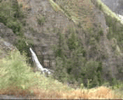
- Robson RiverRobson RiverThe Robson River is a short but swift, rapid and waterfall-infested river in Mount Robson Provincial Park of British Columbia. It is a tributary of the Upper Fraser River and it originates near Robson Pass, which divides the Robson River & the headwaters of the Smoky River drainage...
- Moose RiverMoose River (British Columbia)The Moose River is a river in Mount Robson Provincial Park of British Columbia. It is the first "river" tributary of the Fraser, entering the Fraser just above the inlet to Moose Lake, which ironically, is along the course of the Fraser & not the Moose....
See also
- List of crossings of the Fraser River
- List of crossings of the Thompson River
- List of crossings of the Nechako River
- List of longest rivers of Canada
- French Bar CanyonFrench Bar CanyonFrench Bar Canyon is a canyon on the Fraser River in British Columbia, Canada, near Big Bar and Jesmond, about 60 km upstream from Lillooet.-References:*...
- Fraser CanyonFraser CanyonThe Fraser Canyon is an 84 km landform of the Fraser River where it descends rapidly through narrow rock gorges in the Coast Mountains en route from the Interior Plateau of British Columbia to the Fraser Valley...
- List of British Columbia rivers
- Moran DamMoran DamMoran Dam, also called High Moran Dam or Moran Canyon Dam, was a 1950s proposal to dam the Fraser River in the Canadian province of British Columbia . The structure was planned in the wake of devastating floods in a time of rapidly growing power demand, and if built, would have powered the largest...
(proposal) - Steamboats of the Lower Fraser and Harrison Lake