
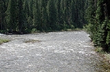
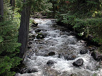
Lochsa River
Encyclopedia
The Lochsa River is located in the northwestern United States
, in the mountains of north central
Idaho
. It is one of two primary tributaries (with the Selway
to the south) of the Middle Fork of the Clearwater River
in the Clearwater National Forest
. Lochsa is a Nez Perce
word meaning rough water.
The Lochsa was included by the U.S. Congress
in 1968 as part of the National Wild and Scenic River
s Act. The Lochsa and Selway rivers and their tributaries have no dams, and their flow is unregulated. In late spring, mid-May to mid-June, the Lochsa River is rated as one of the world's best for continuous whitewater
.
The main stem of the Lochsa is 70 miles (113 km) long from its headwaters near Powell Ranger Station in the Bitterroots
to Lowell, Idaho, where the Lochsa joins the Selway River to form the Middle Fork of the Clearwater. Over this distance, the river drops nearly 2000 feet (609.6 m) from 3441 feet (1,048.8 m) above sea level at Powell to 1453 feet (443 m) at Lowell.
The drainage basin for the Lochsa River system covers 1180 mi2 in Idaho County
. The river is fed by the melting of the significant snowpack of the Bitterroot Range.
in the Bitterroot Mountains
. Just below Lowell, the Lochsa and the Selway River
join to form the Middle Fork Clearwater River
.
At its point of formation just west of Elk Summit Road 360, the Lochsa receives a small tributary, Walton Creek, from the left. The creek flows through a salmon
-rearing station before entering the river. Slightly downstream from the salmon station, the Lochsa passes White Sand Campground on the right. About 1.5 miles (2.4 km) later, it flows by the Powell Ranger Station and heliport
and, shortly thereafter, Lochsa Lodge and Powell Campground, all on the right, and receives Cliff Creek and Jay Creek, both from the left.
Between 66 miles (106.2 km) and 65 miles (104.6 km) from the mouth, the Lochsa receives Papoose Creek from the right, then Robin Creek from the left, and passes Whitehouse Campground and Wendover Campground, both on the right, and receives Wendover Creek from the right. Cold Storage Creek enters from the right at about 64 miles (103 km) from the mouth. Eagle Creek enters from the left about 1 miles (1.6 km) later, and Badger Creek from the right 1 miles (1.6 km) further on. Between 60 miles (96.6 km) and 50 miles (80.5 km) from the mouth, the river receives Doe Creek from the right, passes under the Jerry Johnson Pack Bridge, receives Burnt Creek from the right and Warm Springs Creek from the left; passes Jerry Johnson Campground on the right; receives Colgate Creek from the left and Mink Creek on the right; passes Colgate Warm Springs and the Colgate Licks on the right, and receives Bear Mountain Creek from the right, Post Office Creek from the right, Lake Creek from the left, and passes under Mocus Point Pack Bridge, in that order.
From about 48 miles (77.2 km) to 40 miles (64.4 km) from the mouth, the Lochsa passes Weir Creek Hot Springs and receives Weir Creek and Ginger Creek, both from the right, Mocus Creek from the left, and Ashpile Creek from the right, then Indian Meadows Creek from the left, Indian Grave Creek from the right, passes the White Pine Access Area on the right, receives Eagle Mountain Creek from the left, and passes under Eagle Mountain Pack Bridge, in that order. Over the next 10 miles (16.1 km), the river receives Skookum Creek from the right, Stanley Creek from the left, and Castle Creek from the right, passes Green Flat Campground and Nine Mile Rest Area, both on the right, receives Bald Mountain Creek from the right, and Dutch Creek and Hard Creek from the left. Just below 30 miles (48.3 km) from the mouth, the Lochsa receives Pass Creek from the right and over the next 10 miles (16.1 km) receives No-See-Um Creek, Dipper Creek, and Sherman Creek, all from the right, then Lone Knob Creek from the left, passes Wilderness Gateway Campground on the left and Boulder Flat on the right, receives Boulder Creek from the left, passes the Lochsa Work Center on the right; receives Sardine Creek, Fish Creek, Bee Creek, Eel Creek, and Otter Slide Creek, all from the right, then passes Beaver Flat on the right and receives Big Stew Creek from the left and Snowshoe Creek from the right.
 Between about 19 miles (30.6 km) and 10 miles (16.1 km) from the mouth, the Lochsa receives Macaroni Creek, Wild Horse Creek, and Tomcat Creek, all from the right, Old Man Creek from the left, Tumble Creek from the right, Split Creek from the left, passes under Split Creek Pack Bridge, receives Fire Creek from the left, Bimerick Creek and Tick Creek from the right, Coolwater Creek from the left, passes Knife Edge Campground and Major Fenn Picnic Area on the right, receives Stub Creek from the left, and Deadman Creek from the right, in that order. Over its last 10 miles (16.1 km), the river passes Glade Creek Campground and receives Glade Creek, both on the right, passes Apgar Campground and receives Apgar Creek, both on the right, receives Chance Creek from the left, Canyon Creek from the right, Hellgate Creek and Handy Creek, both from the left, Rye Patch Creek from the right, Cat Creek and Kerr Creek, both from the left, Pete King Creek from the right, passes Icicle Spring on the right, receives Lowell Creek from the right, passes a United States Geological Survey
(USGS) stream gage
0.9 miles (1.4 km) from the mouth, receives Lottie Creek from the left, passes the town of Lowell on the left, passes under the Lowell Bridge, and meets the Selway River.
Downstream from Lowell, the Middle Fork of the Clearwater River flows west, meets the South and North Forks, and enters the Snake River
at Lewiston
on the Idaho—Washington border, 98 miles (157.7 km) by river from Lowell. Below Lewiston, the Snake flows 140 miles (225.3 km) to its confluence with the Columbia River
just south of the Tri-Cities
. Over this stretch, four dams in Washington block the Snake. They are the Lower Granite Dam
, Little Goose Dam
, Lower Monumental Dam
, and Ice Harbor Dam
, in that order.
s in the 19th century, the Nez Perce people in Idaho used the trail along the Lochsa River to travel to the plains of Montana
to hunt buffalo
. Kootenai and Salish
(Flatheads) from Montana used the river trail to reach salmon runs in the rivers and streams feeding into the Columbia basin
.
During mid-September 1805, the explorers Lewis and Clark traveled westward along the Lolo Trail
, descending into and out of the Lochsa Gorge, then above its north rim. They described the region near the modern-day ranger station at Powell as follows:
They experienced significant early season snowfall and suffered near starvation before exiting the mountains onto the Weippe Prairie
, where they first encountered the Nez Perce tribe.
In recent history, the U.S. Forest Service has leased areas of the Upper Lochsa for timber extraction. The Forest Service is currently pursuing a controversial land exchange deal with timber and real estate developer Tim Blixseth
and Western Pacific Timber. Previous land exchange deals with this developer resulted in one of the largest recorded fines for violating environmental laws. The proposed land swap deal has former forest service senior administrators claiming corruption.
follows the Lochsa River along its north bank. One of the last two-lane U.S. highways constructed, it was completed in the early 1960s, connecting Lewiston with Missoula
over Lolo Pass
. Two railroads, the Northern Pacific and Union Pacific
, had originally planned to ascend the Lochsa; the Northern won the rights and even completed some grades in 1908, but abandoned the project in 1909. The highway along the river was not completed for another 50 years.
, black bear
on the hillsides and moose
in meadows and wet places. Among the birds along the river are Canada Geese
, swan
s, eagle
s, Osprey
and Great Blue Heron
s. Wild turkeys are seen at lower elevations. More rare are mountain lions, Snow Geese
, mountain goats, and Harlequin Duck
s. Cutthroat trout
, rainbow trout
, Chinook salmon
and steelhead are among the fish living in the river.
ers and whitewater rafter
s run the Lochsa, generally between April and June. The "Lochsa River Floating Guide" lists more than 60 rapids between Powell and Lowell, most of which are rated Class III-IV (medium to difficult). Depending on the discharge
rate, the level of difficulty can rise in places to Class VI (the limits of navigation) on the International Scale of River Difficulty
. The ratings in the "Floating Guide" reflect the difficulty of the Lochsa's rapids when the water levels at the bridge at Lowell are between 5 feet (1.5 m) and 8 feet (2.4 m). The gage at the bridge differs from the USGS gage. A warning to whitewater rafters posted at the USGS web site for its gage says: "This stage reading is from the USGS gaging station 0.7 miles upstream from Lowell bridge, and it may read between 2-3 feet higher than the stage reading on the staff gage at Lowell bridge. This [the USGS gage reading] is not the stage reference to float the Lochsa River." The USGS site advises rafters to check with the Lochsa Ranger District for readings from the bridge.
The "Floating Guide" describes the Class VI rapids at Castle Creek as follows:
Commercial outfitters offer pre-arranged trips, and people with sufficient technical expertise run the rapids on their own. River access points with parking lots along Highway 12 are at the following sites and highway mile markers: Knife Edge, 107; Split Creek, 111; Fish Creek, 119; Nine Mile, 130, and White Pine, 138.
Other recreation in the watershed includes backcountry skiing
, bicycling on part of the TransAmerica Trail or other roads and trails, fly fishing
with daily limits or catch-and-release
rules, hiking, swimming, camping, and picnicking.
Hazelbaker, Kris (2004). Caring for a wild and scenic river In: Shepperd, Wayne D.; Eskew, Lane G., compilers. 2004. Silviculture in special places: Proceedings of the National Silviculture Workshop; September 8–11, 2003; Granby, CO. Proceedings RMRS-P-34. Fort Collins, CO: U.S. Department of Agriculture, Forest Service, Rocky Mountain Research Station
. pp. 207–16.
Moore, W. R. (1996). The Lochsa story - Land Ethics In The Bitterroot Mountains. Missoula, Montana: Mountain Publishing Co. ISBN 0878423419
United States
The United States of America is a federal constitutional republic comprising fifty states and a federal district...
, in the mountains of north central
North Central Idaho
North Central Idaho is an area which spans the central part of the state of Idaho and borders Oregon, Montana, and Washington. It is the southern half of the Idaho Panhandle region and is rich in agriculture and natural resources. Lewis and Clark travelled throughout this area on their journey to...
Idaho
Idaho
Idaho is a state in the Rocky Mountain area of the United States. The state's largest city and capital is Boise. Residents are called "Idahoans". Idaho was admitted to the Union on July 3, 1890, as the 43rd state....
. It is one of two primary tributaries (with the Selway
Selway River
The Selway River is located in north central Idaho in the northwestern United States within the Selway-Bitterroot Wilderness. It is a tributary of the Middle Fork of the Clearwater River in the Clearwater National Forest...
to the south) of the Middle Fork of the Clearwater River
Clearwater River (Idaho)
The Clearwater River is a river in north central Idaho, which flows westward from the Bitterroot Mountains along the Idaho-Montana border, and joins the Snake River at Lewiston. In October 1805, the Lewis and Clark Expedition descended the Clearwater River in dugout canoes, putting in at "Canoe...
in the Clearwater National Forest
Clearwater National Forest
Clearwater National Forest is located in North Central Idaho in the northwestern United States. The forest is bounded on the east by the state of Montana, on the north by the Idaho Panhandle National Forest, and on the south and west by the Nez Perce National Forest and Palouse Prairie.]The forest...
. Lochsa is a Nez Perce
Nez Perce language
Nez Perce , also spelled Nez Percé, is a Sahaptian language related to the several dialects of Sahaptin . The Sahaptian sub-family is one of the branches of the Plateau Penutian family...
word meaning rough water.
The Lochsa was included by the U.S. Congress
United States Congress
The United States Congress is the bicameral legislature of the federal government of the United States, consisting of the Senate and the House of Representatives. The Congress meets in the United States Capitol in Washington, D.C....
in 1968 as part of the National Wild and Scenic River
National Wild and Scenic River
National Wild and Scenic River is a designation for certain protected areas in the United States.The National Wild and Scenic Rivers Act was an outgrowth of the recommendations of a Presidential commission, the Outdoor Recreation Resources Review Commission...
s Act. The Lochsa and Selway rivers and their tributaries have no dams, and their flow is unregulated. In late spring, mid-May to mid-June, the Lochsa River is rated as one of the world's best for continuous whitewater
Whitewater
Whitewater is formed in a rapid, when a river's gradient increases enough to disturb its laminar flow and create turbulence, i.e. form a bubbly, or aerated and unstable current; the frothy water appears white...
.
The main stem of the Lochsa is 70 miles (113 km) long from its headwaters near Powell Ranger Station in the Bitterroots
Bitterroot Range
The Bitterroot Range runs along the border of Montana and Idaho in the northwestern United States. The range spans an area of 62,736 square kilometers and is named after the bitterroot , a small pink flower that is the state flower of Montana.- History :In 1805, the Corps of Discovery,...
to Lowell, Idaho, where the Lochsa joins the Selway River to form the Middle Fork of the Clearwater. Over this distance, the river drops nearly 2000 feet (609.6 m) from 3441 feet (1,048.8 m) above sea level at Powell to 1453 feet (443 m) at Lowell.
The drainage basin for the Lochsa River system covers 1180 mi2 in Idaho County
Idaho County, Idaho
Idaho County is a county located in the U.S. state of Idaho. As of the 2010 Census the county had a population of 16,267. The county seat is Grangeville...
. The river is fed by the melting of the significant snowpack of the Bitterroot Range.
Course
The Lochsa River begins at the confluence of Crooked Fork and Colt Killed Creek (also called White Sand Creek) near the Powell Ranger Station in northeastern Idaho and flows 70.1 miles (112.8 km) southwest to the small town of Lowell. Running parallel to U.S. Highway 12 for its entire length, the river winds through the Clearwater National ForestClearwater National Forest
Clearwater National Forest is located in North Central Idaho in the northwestern United States. The forest is bounded on the east by the state of Montana, on the north by the Idaho Panhandle National Forest, and on the south and west by the Nez Perce National Forest and Palouse Prairie.]The forest...
in the Bitterroot Mountains
Bitterroot Mountains
The Northern and Central Bitterroot Range, collectively the Bitterroot Mountains, is the largest portion of the Bitterroot Range, part of the Rocky Mountains, located in the panhandle of Idaho and westernmost Montana in the Western United States...
. Just below Lowell, the Lochsa and the Selway River
Selway River
The Selway River is located in north central Idaho in the northwestern United States within the Selway-Bitterroot Wilderness. It is a tributary of the Middle Fork of the Clearwater River in the Clearwater National Forest...
join to form the Middle Fork Clearwater River
Clearwater River (Idaho)
The Clearwater River is a river in north central Idaho, which flows westward from the Bitterroot Mountains along the Idaho-Montana border, and joins the Snake River at Lewiston. In October 1805, the Lewis and Clark Expedition descended the Clearwater River in dugout canoes, putting in at "Canoe...
.
At its point of formation just west of Elk Summit Road 360, the Lochsa receives a small tributary, Walton Creek, from the left. The creek flows through a salmon
Salmon
Salmon is the common name for several species of fish in the family Salmonidae. Several other fish in the same family are called trout; the difference is often said to be that salmon migrate and trout are resident, but this distinction does not strictly hold true...
-rearing station before entering the river. Slightly downstream from the salmon station, the Lochsa passes White Sand Campground on the right. About 1.5 miles (2.4 km) later, it flows by the Powell Ranger Station and heliport
Heliport
A heliport is a small airport suitable only for use by helicopters. Heliports typically contain one or more helipads and may have limited facilities such as fuel, lighting, a windsock, or even hangars...
and, shortly thereafter, Lochsa Lodge and Powell Campground, all on the right, and receives Cliff Creek and Jay Creek, both from the left.
Between 66 miles (106.2 km) and 65 miles (104.6 km) from the mouth, the Lochsa receives Papoose Creek from the right, then Robin Creek from the left, and passes Whitehouse Campground and Wendover Campground, both on the right, and receives Wendover Creek from the right. Cold Storage Creek enters from the right at about 64 miles (103 km) from the mouth. Eagle Creek enters from the left about 1 miles (1.6 km) later, and Badger Creek from the right 1 miles (1.6 km) further on. Between 60 miles (96.6 km) and 50 miles (80.5 km) from the mouth, the river receives Doe Creek from the right, passes under the Jerry Johnson Pack Bridge, receives Burnt Creek from the right and Warm Springs Creek from the left; passes Jerry Johnson Campground on the right; receives Colgate Creek from the left and Mink Creek on the right; passes Colgate Warm Springs and the Colgate Licks on the right, and receives Bear Mountain Creek from the right, Post Office Creek from the right, Lake Creek from the left, and passes under Mocus Point Pack Bridge, in that order.
From about 48 miles (77.2 km) to 40 miles (64.4 km) from the mouth, the Lochsa passes Weir Creek Hot Springs and receives Weir Creek and Ginger Creek, both from the right, Mocus Creek from the left, and Ashpile Creek from the right, then Indian Meadows Creek from the left, Indian Grave Creek from the right, passes the White Pine Access Area on the right, receives Eagle Mountain Creek from the left, and passes under Eagle Mountain Pack Bridge, in that order. Over the next 10 miles (16.1 km), the river receives Skookum Creek from the right, Stanley Creek from the left, and Castle Creek from the right, passes Green Flat Campground and Nine Mile Rest Area, both on the right, receives Bald Mountain Creek from the right, and Dutch Creek and Hard Creek from the left. Just below 30 miles (48.3 km) from the mouth, the Lochsa receives Pass Creek from the right and over the next 10 miles (16.1 km) receives No-See-Um Creek, Dipper Creek, and Sherman Creek, all from the right, then Lone Knob Creek from the left, passes Wilderness Gateway Campground on the left and Boulder Flat on the right, receives Boulder Creek from the left, passes the Lochsa Work Center on the right; receives Sardine Creek, Fish Creek, Bee Creek, Eel Creek, and Otter Slide Creek, all from the right, then passes Beaver Flat on the right and receives Big Stew Creek from the left and Snowshoe Creek from the right.
United States Geological Survey
The United States Geological Survey is a scientific agency of the United States government. The scientists of the USGS study the landscape of the United States, its natural resources, and the natural hazards that threaten it. The organization has four major science disciplines, concerning biology,...
(USGS) stream gage
Stream gauge
A stream gauge, stream gage or gauging station is a location used by hydrologists or environmental scientists to monitor and test terrestrial bodies of water. Hydrometric measurements of water surface elevation and/or volumetric discharge are generally taken and observations of biota may also be...
0.9 miles (1.4 km) from the mouth, receives Lottie Creek from the left, passes the town of Lowell on the left, passes under the Lowell Bridge, and meets the Selway River.
Downstream from Lowell, the Middle Fork of the Clearwater River flows west, meets the South and North Forks, and enters the Snake River
Snake River
The Snake is a major river of the greater Pacific Northwest in the United States. At long, it is the largest tributary of the Columbia River, the largest North American river that empties into the Pacific Ocean...
at Lewiston
Lewiston, Idaho
Lewiston is a city in and also the county seat of Nez Perce County in the Pacific Northwest state of Idaho. It is the second-largest city in the northern Idaho region, behind Coeur d'Alene and ninth-largest in the state. Lewiston is the principal city of the Lewiston, ID - Clarkston, WA...
on the Idaho—Washington border, 98 miles (157.7 km) by river from Lowell. Below Lewiston, the Snake flows 140 miles (225.3 km) to its confluence with the Columbia River
Columbia River
The Columbia River is the largest river in the Pacific Northwest region of North America. The river rises in the Rocky Mountains of British Columbia, Canada, flows northwest and then south into the U.S. state of Washington, then turns west to form most of the border between Washington and the state...
just south of the Tri-Cities
Tri-Cities, Washington
The Tri-Cities is a mid-sized metropolitan area in the southeastern part of the U.S. state of Washington, consisting of three neighboring cities: Kennewick, Pasco, and Richland. The cities are located at the confluence of the Yakima, Snake, and Columbia rivers in the semi-arid region of...
. Over this stretch, four dams in Washington block the Snake. They are the Lower Granite Dam
Lower Granite Lock and Dam
Lower Granite Lock and Dam is a concrete gravity run-of-the-river dam on the Snake River, and bridges Whitman County and Garfield County, in the U.S. state of Washington. The dam is located 22 miles south of the town of Colfax, and 35 miles north of Pomeroy.Lower Granite Dam is part of the...
, Little Goose Dam
Little Goose Lock and Dam
Little Goose Lock and Dam is a hydroelectric, concrete, run-of-the-river dam in Columbia and Whitman counties in the state of Washington, on the Snake River. The dam is located northeast of the town of Starbuck, and north of Dayton....
, Lower Monumental Dam
Lower Monumental Lock and Dam
Lower Monumental Lock and Dam is a hydroelectric, concrete, run-of-the-river dam on the Snake River, and bridges Franklin County and Walla Walla County, in the state of Washington. The dam is located six miles south of the town of Kahlotus, and 43 miles north of the town of Walla...
, and Ice Harbor Dam
Ice Harbor Lock and Dam
Ice Harbor Lock and Dam is a hydroelectric, concrete gravity run-of-the-river dam on the Snake River in Walla Walla and Franklin counties in the U.S. state of Washington. The dam is located 8 miles northeast of the town of Burbank and 12 miles east of Pasco, river mile 9.2...
, in that order.
History
Long before the arrival of European AmericanEuropean American
A European American is a citizen or resident of the United States who has origins in any of the original peoples of Europe...
s in the 19th century, the Nez Perce people in Idaho used the trail along the Lochsa River to travel to the plains of Montana
Montana
Montana is a state in the Western United States. The western third of Montana contains numerous mountain ranges. Smaller, "island ranges" are found in the central third of the state, for a total of 77 named ranges of the Rocky Mountains. This geographical fact is reflected in the state's name,...
to hunt buffalo
American Bison
The American bison , also commonly known as the American buffalo, is a North American species of bison that once roamed the grasslands of North America in massive herds...
. Kootenai and Salish
Confederated Salish and Kootenai Tribes of the Flathead Nation
The Confederated Salish and Kootenai Tribes of the Flathead Reservation are the Bitterroot Salish, Kootenai and Pend d'Oreilles Tribes. The Flatheads lived between the Cascade Mountains and Rocky Mountains. The Salish initially lived entirely east of the Continental Divide but established their...
(Flatheads) from Montana used the river trail to reach salmon runs in the rivers and streams feeding into the Columbia basin
Columbia River Plateau
The Columbia Plateau is a geologic and geographic region that lies across parts of the U.S. states of Washington, Oregon, and Idaho. It is a wide flood basalt plateau between the Cascade Range and the Rocky Mountains, cut through by the Columbia River...
.
During mid-September 1805, the explorers Lewis and Clark traveled westward along the Lolo Trail
Lolo Pass (Idaho-Montana)
Lolo Pass, elevation , is a mountain pass in the United States, in the Bitterroot Range of the northern Rocky Mountains. It is on the border between the states of Montana and Idaho, approximately west-southwest of Missoula, Montana....
, descending into and out of the Lochsa Gorge, then above its north rim. They described the region near the modern-day ranger station at Powell as follows:
" ...the grass entirely eaten out by the horses, we proceeded on 2 miles & Encamped opposit a Small Island at the mouth of a branch on the right side of the river which is at this place 80 yards wide. Swift and Stoney, here we were compelled to kill a Colt for our men & Selves to eat for the want of meat & we named the South fork Colt killed Creek ... The Mountains which we passed to day much worst than yesterday the last excessively bad & thickly Strowed with falling timber & Pine Spruce fur Hackmatak & Tamerack, Steep and Stoney our men and horses much fatigued... "
They experienced significant early season snowfall and suffered near starvation before exiting the mountains onto the Weippe Prairie
Weippe Prairie
Weippe Prairie is a "beautiful upland prairie field of about nine by twenty miles of open farmland bordered by pine forests" at 3,000 feet elevation in Clearwater County, Idaho, at Weippe, Idaho. Camas flowers grow well there, and attracted native gatherers of the camas roots...
, where they first encountered the Nez Perce tribe.
In recent history, the U.S. Forest Service has leased areas of the Upper Lochsa for timber extraction. The Forest Service is currently pursuing a controversial land exchange deal with timber and real estate developer Tim Blixseth
Tim Blixseth
Timothy Lee "Tim" Blixseth is an American real estate developer, record producer, songwriter and timber baron who is best known for co-founding the Yellowstone Club in Montana. Raised in Roseburg, Oregon, Blixseth amassed a fortune in real estate and timber holdings and, in 2006, was featured in...
and Western Pacific Timber. Previous land exchange deals with this developer resulted in one of the largest recorded fines for violating environmental laws. The proposed land swap deal has former forest service senior administrators claiming corruption.
U.S. Route 12
U.S. Route 12U.S. Route 12
U.S. Route 12 or US 12 is an east–west United States highway, running from Grays Harbor on the Pacific Ocean, in the state of Washington, to downtown Detroit, for almost . As a thoroughfare, it has mostly been supplanted by I-90 and I-94, but remains an important road for local travel.The...
follows the Lochsa River along its north bank. One of the last two-lane U.S. highways constructed, it was completed in the early 1960s, connecting Lewiston with Missoula
Missoula, Montana
Missoula is a city located in western Montana and is the county seat of Missoula County. The 2010 Census put the population of Missoula at 66,788 and the population of Missoula County at 109,299. Missoula is the principal city of the Missoula Metropolitan Area...
over Lolo Pass
Lolo Pass (Idaho-Montana)
Lolo Pass, elevation , is a mountain pass in the United States, in the Bitterroot Range of the northern Rocky Mountains. It is on the border between the states of Montana and Idaho, approximately west-southwest of Missoula, Montana....
. Two railroads, the Northern Pacific and Union Pacific
Union Pacific Railroad
The Union Pacific Railroad , headquartered in Omaha, Nebraska, is the largest railroad network in the United States. James R. Young is president, CEO and Chairman....
, had originally planned to ascend the Lochsa; the Northern won the rights and even completed some grades in 1908, but abandoned the project in 1909. The highway along the river was not completed for another 50 years.
Wildlife
Common among the animals using the Lochsa River watershed are deer, elkElk
The Elk is the large deer, also called Cervus canadensis or wapiti, of North America and eastern Asia.Elk may also refer to:Other antlered mammals:...
, black bear
American black bear
The American black bear is a medium-sized bear native to North America. It is the continent's smallest and most common bear species. Black bears are omnivores, with their diets varying greatly depending on season and location. They typically live in largely forested areas, but do leave forests in...
on the hillsides and moose
Moose
The moose or Eurasian elk is the largest extant species in the deer family. Moose are distinguished by the palmate antlers of the males; other members of the family have antlers with a dendritic configuration...
in meadows and wet places. Among the birds along the river are Canada Geese
Canada Goose
The Canada Goose is a wild goose belonging to the genus Branta, which is native to arctic and temperate regions of North America, having a black head and neck, white patches on the face, and a brownish-gray body....
, swan
Swan
Swans, genus Cygnus, are birds of the family Anatidae, which also includes geese and ducks. Swans are grouped with the closely related geese in the subfamily Anserinae where they form the tribe Cygnini. Sometimes, they are considered a distinct subfamily, Cygninae...
s, eagle
Eagle
Eagles are members of the bird family Accipitridae, and belong to several genera which are not necessarily closely related to each other. Most of the more than 60 species occur in Eurasia and Africa. Outside this area, just two species can be found in the United States and Canada, nine more in...
s, Osprey
Osprey
The Osprey , sometimes known as the sea hawk or fish eagle, is a diurnal, fish-eating bird of prey. It is a large raptor, reaching more than in length and across the wings...
and Great Blue Heron
Great Blue Heron
The Great Blue Heron is a large wading bird in the heron family Ardeidae, common near the shores of open water and in wetlands over most of North and Central America as well as the West Indies and the Galápagos Islands. It is a rare vagrant to Europe, with records from Spain, the Azores and England...
s. Wild turkeys are seen at lower elevations. More rare are mountain lions, Snow Geese
Snow Goose
The Snow Goose , also known as the Blue Goose, is a North American species of goose. Its name derives from the typically white plumage. The genus of this bird is disputed...
, mountain goats, and Harlequin Duck
Harlequin Duck
The Harlequin Duck is a small sea duck. It takes its name from Arlecchino, Harlequin in French, a colourfully dressed character in Commedia dell'arte. The species name comes from the Latin word "histrio", "actor". In North America it is also known as Lords and ladies...
s. Cutthroat trout
Cutthroat trout
The cutthroat trout is a species of freshwater fish in the salmon family of order Salmoniformes. It is one of the many fish species colloquially known as trout...
, rainbow trout
Rainbow trout
The rainbow trout is a species of salmonid native to tributaries of the Pacific Ocean in Asia and North America. The steelhead is a sea run rainbow trout usually returning to freshwater to spawn after 2 to 3 years at sea. In other words, rainbow trout and steelhead trout are the same species....
, Chinook salmon
Chinook salmon
The Chinook salmon, Oncorhynchus tshawytscha, is the largest species in the pacific salmon family. Other commonly used names for the species include King salmon, Quinnat salmon, Spring salmon and Tyee salmon...
and steelhead are among the fish living in the river.
Recreation
KayakKayak
A kayak is a small, relatively narrow, human-powered boat primarily designed to be manually propelled by means of a double blade paddle.The traditional kayak has a covered deck and one or more cockpits, each seating one paddler...
ers and whitewater rafter
Rafting
Rafting or white water rafting is a challenging recreational outdoor activity using an inflatable raft to navigate a river or other bodies of water. This is usually done on white water or different degrees of rough water, in order to thrill and excite the raft passengers. The development of this...
s run the Lochsa, generally between April and June. The "Lochsa River Floating Guide" lists more than 60 rapids between Powell and Lowell, most of which are rated Class III-IV (medium to difficult). Depending on the discharge
Discharge (hydrology)
In hydrology, discharge is the volume rate of water flow, including any suspended solids , dissolved chemical species and/or biologic material , which is transported through a given cross-sectional area...
rate, the level of difficulty can rise in places to Class VI (the limits of navigation) on the International Scale of River Difficulty
International Scale of River Difficulty
The International Scale of River Difficulty is a standardized scale used to rate the safety of a stretch of river, or a single rapid. The grade reflects the technical difficulty and skill level required associated with the section of river...
. The ratings in the "Floating Guide" reflect the difficulty of the Lochsa's rapids when the water levels at the bridge at Lowell are between 5 feet (1.5 m) and 8 feet (2.4 m). The gage at the bridge differs from the USGS gage. A warning to whitewater rafters posted at the USGS web site for its gage says: "This stage reading is from the USGS gaging station 0.7 miles upstream from Lowell bridge, and it may read between 2-3 feet higher than the stage reading on the staff gage at Lowell bridge. This [the USGS gage reading] is not the stage reference to float the Lochsa River." The USGS site advises rafters to check with the Lochsa Ranger District for readings from the bridge.
The "Floating Guide" describes the Class VI rapids at Castle Creek as follows:
Probably the largest, most technical rapid on the river. A long, twisting rapid whose 1/2-mile length is not totally observable from the water at any one time. Large holes become large waves at high water, and everything pillows left off a huge block of bedrock at the bottom of the rapid. Considered un-runnable at high flows. Must scout. Cannot be seen from highway.
Commercial outfitters offer pre-arranged trips, and people with sufficient technical expertise run the rapids on their own. River access points with parking lots along Highway 12 are at the following sites and highway mile markers: Knife Edge, 107; Split Creek, 111; Fish Creek, 119; Nine Mile, 130, and White Pine, 138.
Other recreation in the watershed includes backcountry skiing
Backcountry skiing
Backcountry skiing is skiing in a sparsely inhabited rural region over ungroomed and unmarked slopes or pistes, including skiing in unmarked or unpatrolled areas either within the ski resort's boundaries or in the backcountry, frequently amongst trees , usually in pursuit of fresh fallen powder...
, bicycling on part of the TransAmerica Trail or other roads and trails, fly fishing
Fly fishing
Fly fishing is an angling method in which an artificial 'fly' is used to catch fish. The fly is cast using a fly rod, reel, and specialized weighted line. Casting a nearly weightless fly or 'lure' requires casting techniques significantly different from other forms of casting...
with daily limits or catch-and-release
Catch and release
Catch and release is a practice within recreational fishing intended as a technique of conservation. After capture, the fish are unhooked and returned to the water before experiencing serious exhaustion or injury...
rules, hiking, swimming, camping, and picnicking.
Further reading
Endangered and Threatened Wildlife and Plants; Proposed Designation of Critical Habitat for the Klamath River and Columbia River Distinct Population Segments of Bull Trout. Washington D.C. ; U.S. Fish and Wildlife Service. Office of Endangered Species, 2002Hazelbaker, Kris (2004). Caring for a wild and scenic river In: Shepperd, Wayne D.; Eskew, Lane G., compilers. 2004. Silviculture in special places: Proceedings of the National Silviculture Workshop; September 8–11, 2003; Granby, CO. Proceedings RMRS-P-34. Fort Collins, CO: U.S. Department of Agriculture, Forest Service, Rocky Mountain Research Station
Rocky Mountain Research Station
The Rocky Mountain Research Station is one of five regional units that make up the US Forest Service Research and Development organization — the most extensive natural resources research organization in the world. The station headquarters are located in Fort Collins, Colorado. The director is...
. pp. 207–16.
Moore, W. R. (1996). The Lochsa story - Land Ethics In The Bitterroot Mountains. Missoula, Montana: Mountain Publishing Co. ISBN 0878423419
External links
- Bearpaw River Expeditions - Custom Lochsa Raft Trips
- The Weather Channel - Epic Adventures - Lochsa River, Idaho
- Lochsa.info - stream flows, weather, etc.
- Backcountry Secrets.com - Lochsa River, Idaho
- Idaho Whitewater Trail Map - official state tourism site
- Paddling.net - Lochsa River, Idaho
- Topographic map - Lowell, Idaho from USGS via Microsoft Research Maps
- Kayak Idaho.com - photos - Idaho rivers
- ROW Adventures.com - Lochsa River
- Rafting Adventures.com - Lochsa River
- Lewis and Clark Trail Adventures - Lochsa River
- Lochsa Historical Ranger Station Museum