

Esopus Creek
Encyclopedia
Esopus Creek is a 65.4 miles (105.3 km) tributary
of the Hudson River
that drains the east-central Catskill Mountains
of the U.S. state
of New York
. From its source at Winnisook Lake
on the slopes of Slide Mountain, the Catskills' highest peak, it flows across Ulster County
to the Hudson at Saugerties
. Many tributaries extend its watershed
into neighboring Greene County
and a small portion of Delaware County
. Midway along its length, it is impounded
at Olive Bridge
to create Ashokan Reservoir
, the first of several built in the Catskills as part of New York City
's water supply system. Its own flow
is supplemented 13 miles (20.9 km) above the reservoir by the Shandaken Tunnel
, which carries water from the city's Schoharie Reservoir
into the creek.
It takes its name from the Esopus tribe of the Lenape
, who were the Native American
residents of the lower Esopus when the Dutch
first explored and settled the Hudson Valley
in the early 17th century. The creek's wide valley made it an ideal trading route for the Esopus and other Lenape who harvested the beaver
pelts the European traders desired. Later, under the English, it became the beginning point for contentious land claims in the mountains. After independence, the Esopus corridor became the main route into the Catskills, first by road then later by the Ulster and Delaware Railroad
, for forest-product industries like logging, tanning and charcoal-making. Those industries declined in the late 19th century, shortly before the creation of the Forest Preserve
and the Catskill Park made the region more attractive for resorts and recreation, particularly trout
fishing. The renewed Esopus also attracted the attention of fast-growing New York City, which was able to acquire land and build the reservoir and tunnel after overcoming local political opposition.
It divided the creek into an upper stretch, mostly a wild mountain stream, and a lower stretch closer to the Hudson that gradually becomes more estuarine
. Above the reservoir, its water quality
is closely monitored, not only for its role in the city's water supply but to preserve its local economic importance as a recreational resource. As one of the most productive trout streams in the Northeast
, fly fishermen
still come in great numbers to take trout from its relatively accessible banks. Canoeists
and kayakers
have been drawn to its whitewater
, which has also spawned a busy local tubing
industry in the summer months. The lower Esopus is mainly an aesthetic and ecological resource, although the estuary at Saugerties is a popular bass fishery
.
The Esopus's role in the state and regional economy has led to a concentrated effort to protect and manage it, particularly on the upper stretch. The interests of the various stakeholders have not always converged, particularly where it concerns the city's management of its water needs. Turbidity
created by discharges from the Shandaken Tunnel after a 1996 flood led to a successful lawsuit against the city and a state regulation; downstream of the reservoir the city has been criticized for contributing to flooding problems by releasing too much water during heavy rainstorms. Boaters and anglers have also clashed, and invasive species
are beginning to enter the upper creek as well.
The upper portion, where most recreational use takes place, has the characteristics of a mountain stream — shallow, rocky and swift and is where most trout fishing takes place. Below the reservoir's spillway the stream begins again, becoming flatter, deeper and slower to its short estuary
.
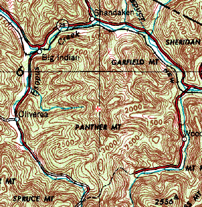
on the northwest slopes of Slide Mountain, the Catskills' highest peak, within 300 feet (100 m) of the West Branch of the Neversink River
on the other side of the divide between the Hudson and Delaware
watershed
s. It descends from there northward into Big Indian Hollow, dropping a thousand feet (305 m) in its first mile (1.6 km), a narrow and rocky stream through this section. Its curving course marks the walls of the buried meteor
impact crater
that created Panther Mountain
to the east. Several tributaries flow down from the slopes of Fir
, Big Indian
, Balsam
and Belleayre mountains to the west.
At the hamlet of Big Indian
, it receives Birch Creek, which drains from the small former village of Pine Hill
to the west, and then turns eastward, closely paralleling state highway
NY 28
. Bushnellsville Creek flows in from the north, where it drains Deep Notch
and the slopes of Halcott Mountain
and Mount Sherrill
. Through this section it widens to 15–40 ft (4.6–12.2 ). Five miles (9 km) further west, near the small former hamlet of Shandaken
, the 18 miles (29 km) Shandaken Tunnel
brings water from Schoharie Reservoir
into the Esopus, a junction known by fishermen as the Portal, increasing its flow.
The creek continues westward, now 40–80 ft (12.2–24.4 ) wide, along the circular route around Panther. At Phoenicia
, four miles (6.5 km) west of the Portal, the first major settlement along its course, Woodland Creek flows in from the south along the other side of the circle from its headwaters on Wittenberg Mountain
. At the NY 214
junction, the Esopus receives Stony Clove Creek
from the north, where it drains southern Greene County
. The creek is now 60–100 ft (18.3–30.5 ) wide but shallow here, remaining on the north side of Route 28 as the Catskill Mountain Railroad
parallels its banks. It crosses and recrosses the highway after Mount Tremper
.
Just west of Route 28's intersection with NY 212
at Mount Pleasant
, the Esopus crosses Route 28 again in an area with flood control
measures along its banks. It stays south of the road all the way to where NY 28A
crosses it above the west end of Ashokan Reservoir
. This is the end of the creek's 26 miles (41.8 km) upper section.
near Olive Bridge. Its eastern section, slightly to the north, is not part of the creek's course. Below the dam, having descended almost 2000 feet (609.6 m) from Winnisook Lake, it runs through a wild, rocky section with cascades and rapid
s, flowing southeast, away from Route 28, until it reaches US 209 at Marbletown
. There, it turns northeast and parallels the road to Hurley
, where it crosses.
 After the New York State Thruway
crosses just west of Kingston
, the Esopus bends to the north and meanders parallel to it. After Route 209 crosses again, it receives the Saw Kill, which drains the southeastern corner of Greene County, from the west and straightens out past Lake Katrine
. The riverside is more developed here, with homes and docks on the east bank. Just southeast of the village of Saugerties
, it turns east and forms the south boundary of the village, with one bridge carrying US 9W
and NY 32
. Just below the bridge it flows over a small dam. It bends north, passes Saugerties Light
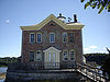
, and empties into the Hudson 1.3 miles (2.1 km) east of the dam.
to the present day.
era, when the Catskills were still a river delta
of low sedimentary beaches and the shallow channels between them to a large inland sea that corresponds to the location today of the Allegheny Plateau
. A meteor impact
during this time left a crater
whose walls correspond to the courses of the upper Esopus and Woodland Creek today. Geologist Yngvar Isachsen of the New York State Geological Survey discovered the traces of the meteor impact, including a higher fault density in the bedrock on the Esopus, in the late 20th century.
Later, the crater began to fill in with silt and became a crater lake
, as the delta uplifted
into a single plateau
, the stream began to form along the weakened shale
and sandstone
at what had been the rim of the crater wall. As with the Catskills as a whole the newly forming streams began dissecting
the plateau into mountains and valleys. This process led the Esopus, with its particularly deep and wide valley, to fill up its bed with the red clay
that clouds the waters of the stream in high water and floods. More recently in geologic time, about 12,000 years ago, the Wisconsin glaciation
filled the valley, carving the slopes on its sides more steeply and eroding more sediment into the river. It shaped the lower Esopus as well, as the long glacial ridges closer to the Hudson channeled the stream north to Saugerties after they melted.
As the glaciers melted slowly, they created ice dam
s and glacial lake
s. The most significant along the Esopus's course left behind the large plain at Shokan. In the 20th century the original lake would be recreated as Ashokan Reservoir
.
The Esopus was one of three valleys trees followed into the Catskills as revegetation
of the mountain slopes took place in the glaciers' wake. First to come were the boreal species, such as balsam fir
, that today persist only on the summits of the range's higher peaks
. Next were the northern hardwood
s, primarily beech
, birch
and maple
species, that dominate much of the Catskill forests today. Last were southern hardwood species, mostly oak
, hickory
and American chestnut
, probably following the Indians as they migrated north. Most of the chestnuts died in the chestnut blight
of the early 20th century. Catskill forest historian Michael Kudish
found that other southern hardwood species can be found in the Esopus valley all the way to Oliverea, a mile or so below the creek's source.
used the flat flood plains of the lower Esopus for cornfields, and there are accounts of the area around Olive, today innundated by the reservoir, planted as an apple orchard
. The Natives did not settle the area permanently, and only ventured into the higher reaches of the valley to hunt as there was less arable land there.
The Esopus would be important to the area's early European colonization
. It took its name from the Lenape
band that inhabited its banks, some of whom entertained Henry Hudson
on his voyage up the river in 1609 after possible earlier contact with fur traders. European traders began plying the river in greater numbers, eventually establishing permanent settlements for the purpose. Dutch settlers
established Wiltwyck, today's Kingston
, on the high ground between the Esopus and the Rondout
in 1649. After the Esopus drove them out of the settlement
in two wars
, colonial governor Peter Stuyvesant
ordered that it be enclosed in a stockade
so it would be safer from raids by Indians and the other contending colonial power in the area, the English. The latter took over the New Netherland
colony in 1664, taking a more nuanced approach to the native peoples of the area.
The settlement's location above the point where the Esopus came out of the Catskills made it an ideal trading post
for Indians responding to the European demand for beaver pelts to make the beaver hat
s then in vogue. In the later 17th century, with European settlement well established around the eastern Catskills, land replaced fur as the Indian-held commodity most desired by the new arrivals. The English government in London charged local officials with granting
large chunks of land on the colonial frontier so that it might be better protected from the French
to the north and west, but those officials dallied, only making such grants when they could enrich themselves and their friends in the process. The Catskills and the Esopus Valley, with little land that could be cleared for farming, were not suitable to that end.
petitioned the colonial governor, Viscount Cornbury
, for some of the undeveloped land to their west along the creek to use as common pasture
and firewood, since they were getting squeezed by Kingston to their east and Marbletown
to the south. The petition was put off for several years while it was ostensibly being surveyed, and in 1706 a grant of 2 million acres (8,000 km²) was made to Johannes Hardenbergh
and a group of investors starting from the same point along the Esopus near Kingston and going out to the Delaware River
, taking not only all of Ulster County to the west but much of today's Delaware
and Sullivan
counties as well. The Hardenbugh Patent, as it became known, is the source of much of the land titles
in the Catskills today, although its legitimacy was contested from the beginning, a dispute which continued until after the Revolution
, aggravated by inadequate surveys
of the region. Encumbrance
s remained on many properties into the 20th century.
The complications with the land claim delayed an accurate survey of the Catskills until 1885. In the meantime permanent settlement of the Esopus valley began in the mid-18th century and finished with the establishment of the Slide Mountain post office in 1805. Most of these communities were supported by local forest-products industries: loggers harvested trees for sawmill
operators, and furniture makers set up shop nearby. A road, the Ulster, Delaware and Dutchess Turnpike, was improved from an old colonial path that led up the valley and then into Delaware County past Highmount. It would, by the middle of the century, be paralleled by the Ulster and Delaware Railroad
.
Timber wasn't the only product taken from the mountainsides and sent down the valley. Tanners
brought up cowhide
s via those routes to treat in water boiled in hemlock
bark, and charcoal
kiln
s were more numerous in the Esopus Valley than anywhere else in the Catskills. Bluestone
for city sidewalks and buildings was also quarried out of the hills. These industries had a deleterious effect on the creek at the center of the valley, adding eroded soil and pollutants to it.
from eroded Adirondack
slopes to clog the Erie Canal
had led the state's business community to rally for the creation of the Forest Preserve
in 1885. A legislative maneuver by the Ulster County delegation later that year added the Catskills, relieving the county of property tax
obligations to the state on lands it had taken by foreclosure after the tanners and loggers had harvested everything of value and absconded with the revenue. The lands transferred to the state by the legislation were required to be kept forever wild. The legislation became Article 14 of the state constitution nine years later, in 1894, with added provisos that prohibited their sale, lease or any other transfer without a new amendment
authorizing such a transaction.
By that era most of the easily accessible woodlands had been harvested. In combination with technological advances in some fields that eliminated the need for the raw materials of the forest, most of the industries that had made such an impact on the region in the early 19th century declined. In their place a new one arose, mountain tourism, giving the newly affluent of the Gilded Age
a place to connect with nature and get away from hot cities in the summer months.
One destination resort was the Tremper Mountain House, outside Phoenicia
on the slopes of Mount Tremper
. During its peak period in the 1880s, it had a small trout pond out front. The house doctor, H.R. Winter, was an avid practitioner and promoter of the new sport of fly fishing
, which he believed had therapeutic effects, making "a person for a time forget he ever had any care, business, or anxiety".
Anglers of the era who ventured into the Esopus valley were usually advised by guidebooks and magazine articles touting the Catskills' trout populations to bypass the main stream in favor of the tributaries, since the Esopus itself was generally too warm for brook trout, the favored species at that time, and still too polluted by runoff from the tanneries. In the 1880s pioneering fish farmer
Seth Green
advocated the stocking of rainbow trout in streams where the brook trout population was beginning to thin as a result of the fishing pressure, as they could handle warmer water better. Other anglers feared that, if introduced, the more aggressive rainbows would displace the native brooks.
In 1883 and 1884, thousands of rainbow fry and mature fish were stocked in the Esopus between Phoenicia and Big Indian. They soon became the stream's dominant fish, and the Esopus became an angling destination in its own right. Specimens of 3–4 pounds (1.2–1.6 kg) were reported, and some were displayed in tanks at the Big Indian Railroad Station
.
 Unlike the Beaver Kill and Willowemoc Creek
to the south, the development of Esopus Creek as a fishing stream did not result in the establishment of private fishing clubs, with one exception. In 1887 Alton Parker and his friends bought the 600 acres (242.8 ha) on the slopes of Slide Mountain where the stream's source was located. They dammed the stream and created the 6.4 acres (2.6 ha) Winnisook Lake
, the highest lake in the Catskills, for their exclusive enjoyment. In 1896 the members received William Jennings Bryan
, then the Democratic
nominee for President, as a guest. His visit attracted much attention locally, with residents lining the Ulster and Delaware's rails to see him and huge crowds waiting to shake his hand at stations.
 In 1861 the city of Kingston had considered buying the land around Bishop's Falls near Ashokan to dam and use as a reservoir. It dropped the idea quickly since the creek's waters were still fouled by tanning effluents. A quarter-century later it took a second look, and found the waters had returned to their pristine state with the tanneries gone. It eventually developed Cooper Lake (New York)
on a tributary of the Saw Kill, for its water needs instead, after the privately owned Ramapo Water Company bought the rights
.
Twenty years after that, in the early years of the 20th century, New York City's reservoirs in Westchester
and Putnam
counties were barely keeping up with the growing city's demand. The city's agents looked at land along the Ramapo River
on the other side of the Hudson, in Rockland
and Orange
counties, for new reservoir sites, but found the Ramapo Water Company had gotten their first, and was locking up similar rights in Delaware and Sullivan counties as well. The city balked at rewarding this act of speculative
profiteering, and after political wrangling the state created water commissions and granted the city the exclusive right to acquire land in the Esopus and Schoharie
watersheds and construct two reservoirs. The former was particularly promising as a water source since the summit of Slide Mountain, the north slopes of which are in the creek's watershed, gets 63 inches (1,600.2 mm) of precipitation
annually, the highest average annual rainfall in not only the Catskills but the state.
Residents in the Esopus valley objected to the dislocation the proposed reservoir would require, forcing out the population of seven hamlets and relocating the Ulster and Delaware. They also noted that both reservoirs would be outmoded in a decade, requiring the construction of more reservoirs, and suggested the city look further north, to the Adirondacks. They feared the dam would fail, and called the project the "Esopus folly".
The state's water supply commission ruled in the city's favor, and once the city began acquiring land most local objections faded because local lawyers, well versed in the tangled history of land claims on the former Hardenburgh Patent, were able to negotiate prices highly favorable to local landowners. The reservoir was completed in 1913 and began delivering its first water to the city via the Catskill Aqueduct
two years later. It became the prototype for six other reservoirs built in the region over the next half century.
The water releases from the Portal made the sections below it into a whitewater
stream with rapids of Class II-III on the International Scale of River Difficulty
. In the mid-1960s the Kayak and Canoe Club of New York began holding an annual whitewater slalom near Phoenicia. Later businesses in the hamlet began offering tubing
to summer visitors; it has become one of the most popular recreational activities on the creek despite its negative impact on angling and occasional fatalities.
In the late 20th century, the population of the upper Esopus valley has more than doubled. Most of the increase comes from residential land use, which has also more than doubled as agricultural use has decreased 80%. Newer residents are primarily using the area for second home
s.
, nets
, and even sledgehammers, to catch enough to make sure their families had plenty to eat whatever the outcome of their harvests. By the 1840s the Esopus's trout fishery was beginning to attract anglers from outside the region. Many stayed at Milo Barber's Inn in Shandaken
.
Today the upper Esopus still attracts many anglers
who fly-fish
for trout
, particularly because the state land around it in the Slide Mountain
and Big Indian-Beaverkill wilderness areas makes it more accessible than other streams in the region, with a number of public parking areas. In the late 19th century it became the first place in the Catskills where rainbow trout
were successfully stocked
, and the population of that fish has since become indigenous to the point that it is considered one of the most productive wild-trout streams in the Northeast
. The state augments it with regular stockings of brown trout
as well. Because of that species' preference for later spawning dates in the fall, trout season along the Esopus extends until November 30, a month and a half later than most other streams in the state.
The Esopus is the only stream in the county with no minimum size restriction; up to five may be taken per day. Most fish taken are thus less than 12 inches (30.5 cm) in length, but in 1923 a brown trout was taken at Chimney Hole just above the reservoir that weighed 19 pounds (8.6183 kg). It was a state record that stood for three decades.
 Anglers subdivide the upper Esopus into four sections: the small Esopus, from Winnisook Lake to Big Indian, and the three sections of the big Esopus. These are from Big Indian to the Portal, from the Portal to Phoenicia, and from Phoenicia to the reservoir.
Trout, along with walleye
, bass
and crappie
are also taken in the reservoir, where anglers must have a permit from the New York City Department of Environmental Protection
as well as a state license. They must use unpowered boats stored at designated areas along the shoreline and used only in the reservoir. Here there is a 12-inch minimum with a limit of three per day.
The creek's estuary
below the dam at Saugerties has also become a popular spot for bass fishing
. Several tournaments
are held for both largemouth
and smallmouths
. Striped bass
from the Hudson also spawn in the estuarine Esopus, making it a popular spot for them as well.
. They only run the Esopus when the stream gauge
at Cold Brook near the put-in records water levels from 5–6.25 ft (1.5–1.9 ). These usually occur after major releases from the Portal or heavy rains. The KCCNY has its annual 400 metres (1,312.3 ft) whitewater slalom race in early June after one of the former. The American Canoe Association
has also held its Atlantic Division Championships there every fall since 1979, and the stream hosted the U.S. Open Canoe Championship there in 1980.
The lower Esopus is also attractive to boating enthusiasts who prefer flatwater. Much of it outside the Esopus Bend Nature Preserve is private property, open to the public only once a year when the Esopus Creek Conservancy holds its annual Decks and Docks on the Esopus fundraiser
. Marina
s on the estuary in Saugerties shelter craft used on the Hudson.
Tubing
the Esopus above and below Phoenicia has long been popular, with about 15,000 people a year taking the float. Since the 1970s, local businesses have rented tubes to visitors, and it has become a major draw to the Catskills in summertime. Some residents complaining about its local impact and its negative effect on fishing (Other anglers are not as bothered by tubers, pointing out most tubing takes place during daylight hours rather than the crepuscular
times at which trout are most active).). The Shandaken Town Board proposed a law in 1983 that would have limited tubing to the lower stretch during prescribed hours, required bathroom facilities and levied a 10-cent surcharge
on each rented tube to cover the expenses to the town. It was not adopted, but later the town required a special use permit under its zoning
code. That requirement was dropped after one of the tube-rental businesses challenged it in court.
Currently, two companies in the area rent to visitors, who can choose between the wilder but more dangerous stretch north of the hamlet (not recommended for children) or the calmer stretch below it. Those who take the latter option can ride the Catskill Mountain Railroad
back. Tubes are rented only when the stream gauge at Coldbrook indicates a level of 4–6 ft (1.2–1.8 ).
. Below the reservoir it is not a source of drinking water, and its surrounding land is more heavily farmed. Conservation efforts on that stretch primarily focus on its aesthetic and ecological role.
(DEP). Between the DEC's Forest Preserve
holdings, city-owned buffer lands and privately held forested parcels, 99% of the land in the upper watershed is forested. Trout fishermen are also active through groups like Trout Unlimited
in working to keep the creek's water clean, although their interests sometimes clash with the city's.
According to the 2007 Upper Esopus management plan compiled by DEP, the Cornell
Cooperative Extension
and the U.S. Army Corps of Engineers for the Ashokan Watershed Stream Management Program, water quality
in that part of the stream is generally good. Property owners and other stakeholders in the stream expressed concern about flooding risks and attendant erosion
problems. The plan did not find any evidence that floods have become more common in the last century (the record flood for the stream occurred in 1980, with discharges
of 65300 cuft/s recorded above the reservoir and was calculated to be a 40-year flood
), despite two heavy floods in the preceding decade. It recommends that new construction on the creek's flood plain be avoided wherever possible and that flood control measures and warning systems be improved along the length of the upper creek.
The Portal's effect on the creek's fishery
is a continuing source of friction. For a long time after its construction it was believed to have a positive effect on the trout, but after the floods of 1996 some fishermen began complaining that the waters from Schoharie have been too turbid
and warm (some calling it "Yoo Hoo Creek"), with the rainbow trout population declining as a consequence. New York's Department of Environmental Conservation
(DEC) says it has found no sign of that, but in 2000 the Catskills chapter of Trout Unlimited, Riverkeeper
and some other groups sued the city, arguing the Portal releases into the creek violated the federal Clean Water Act
. After lengthy litigation the city was eventually required to get a state permit for the discharges. Environmental groups have said the problems would be solved if the Schoharie, like all the other city reservoirs, had a multi-level discharge structure, allowing water to be taken from the less turbid surface as well as the cooler depths.
Boater and tuber user groups depend on releases from the Portal, which can add up to 900 cuft/s to the creek's flow, to make those activities possible. Their interests also sometimes differ with the stream's angling community on the question of large woody debris (LWD), such as trees or limbs loosened from the banks during floods. Those usually come to rest in the stream, sometimes at bridge abutment
s, creating habitat for trout and other aquatic life but creating navigational hazards. In 2002 a kayaker and tuber were killed in separate instances as a result of LWD in the stream; both deaths led to lawsuits against property owners. The management plan has recommended clarifying the liability
issues.
Riparian buffer
s are another issue to be addressed. Most of the upper Esopus has at least 100 feet (30 m) of buffer on either side, but there are portions with 25 feet (7.6 m) or less and 6.25 miles (10.1 km) have no buffer at all, with revetment
s shoring up the sides next to the highway or the railroad. The buffers are mostly closed-canpoy floodplain forests, with mowed lawns making up the remainder. In recent years colonies of Japanese knotweed
, an invasive species
, have been observed along the banks and in buffer areas. They are considered detrimental to the stream's health since they do not provide shade, are less effective at controlling erosion and, since they grow in thick clusters, impede access to the stream.
Oriental bittersweet
, a vine which kills the trees in buffer forests by wrapping itself tightly around them, has also been observed in some areas. The stream management plan recommends that a comprehensive plan be developed for controlling and eradicating both species, and any others that may be found in the future.
In 2009, the invasive species problem in the buffers was complicated further by the confirmed arrival of Didymosphenia geminata
, an algae
species commonly referred to as rock snot, in the creek's waters between Shandaken and the reservoir. It was the third stream in the state where it has been found, after Batten Kill
in Washington County
and the East
and West
branches of the Delaware River
in Delaware County, just to the west of the Esopus valley. The species can clog water intakes but poses no threat to human life. Trout are more at risk because it often grows over river bottoms, smothering the insect hatches they depend on as a food source. There is no way at present to eradicate the species; the state has instead advised fishermen to thoroughly clean and disinfect their waders
after trips in order to slow its growth and prevent it from reaching other streams.
began holding an annual Esopus Creek Lower Basin Watershed Conference. One of its chief concerns was the effects of that flood on the region, where it took some farmers several months to recover from its effects.
The town of Marbletown
, first along the stream's course below the Esopus, was where much of the farmland affected by the flood was located. Silt and other eroded materials pile up on the land and must be removed, and some of the farmland was lost permanently. Marbletown has planned to work with its farmers to acquire development
rights to at least 750 acres (303.5 ha) outside the creek's flood plain, which cannot be developed, and further protect the rare plant and animal communities along the creek in addition to minimizing the effect of any future floods.
Flooding concerns in the lower Esopus have also led to criticism of the DEP for maintaining the reservoir at capacity levels that may be higher than necessary, requiring releases during periods of heavy rain that aggravate flooding. In 2010 the city began implementing new computer software that more closely monitors water levels in all its reservoirs as well as data that allows it to estimate near term water availability. Local officials, particularly State Senator
John Bonacic
, praised the move but said they would keep working for DEP to be more conscious of its impact on downstream property owners
Further downstream, in the Saugerties area, conservation efforts have been led by the Esopus Creek Conservancy, a non-profit organization
that works to conserve the landscapes and ecosystem
s around the creek. It was created in 1999 from a local citizen's efforts to protect a section of creekside property from development. Five years later, with the help of the Catskill Center for Conservation and Development
, the land was purchased and the conservancy formed. It is now the 161 acres (65.2 ha) Esopus Bend Nature Preserve, just outside the village of Saugerties, that protects a long stretch of crucial habitat along the south shore of the creek. Trails within it lead to views over the creek to the Catskill Escarpment
beyond.
Tributary
A tributary or affluent is a stream or river that flows into a main stem river or a lake. A tributary does not flow directly into a sea or ocean...
of the Hudson River
Hudson River
The Hudson is a river that flows from north to south through eastern New York. The highest official source is at Lake Tear of the Clouds, on the slopes of Mount Marcy in the Adirondack Mountains. The river itself officially begins in Henderson Lake in Newcomb, New York...
that drains the east-central Catskill Mountains
Catskill Mountains
The Catskill Mountains, an area in New York State northwest of New York City and southwest of Albany, are a mature dissected plateau, an uplifted region that was subsequently eroded into sharp relief. They are an eastward continuation, and the highest representation, of the Allegheny Plateau...
of the U.S. state
U.S. state
A U.S. state is any one of the 50 federated states of the United States of America that share sovereignty with the federal government. Because of this shared sovereignty, an American is a citizen both of the federal entity and of his or her state of domicile. Four states use the official title of...
of New York
New York
New York is a state in the Northeastern region of the United States. It is the nation's third most populous state. New York is bordered by New Jersey and Pennsylvania to the south, and by Connecticut, Massachusetts and Vermont to the east...
. From its source at Winnisook Lake
Winnisook Lake
Winnisook Lake is an artificial lake located in Oliverea, New York, United States. It is the source of Esopus Creek and the highest lake in the Catskill Mountains at above sea level....
on the slopes of Slide Mountain, the Catskills' highest peak, it flows across Ulster County
Ulster County, New York
Ulster County is a county located in the state of New York, USA. It sits in the state's Mid-Hudson Region of the Hudson Valley. As of the 2010 census, the population was 182,493. Recent population estimates completed by the United States Census Bureau for the 12-month period ending July 1 are at...
to the Hudson at Saugerties
Saugerties (village), New York
Saugerties is a village in Ulster County, New York, USA. The population was 4,955 at the 2000 census.The Village of Saugerties is a Town in the eastern part of the Town of Saugerties. U.S. Route 9W passes through the village...
. Many tributaries extend its watershed
Drainage basin
A drainage basin is an extent or an area of land where surface water from rain and melting snow or ice converges to a single point, usually the exit of the basin, where the waters join another waterbody, such as a river, lake, reservoir, estuary, wetland, sea, or ocean...
into neighboring Greene County
Greene County, New York
Greene County is a county located in the U.S. state of New York. Its name is in honor of the American Revolutionary War general Nathanael Greene. Its county seat is Catskill...
and a small portion of Delaware County
Delaware County, New York
Delaware County is a county located in the U.S. state of New York. As of 2010 the population was 47,980. The county seat is Delhi. It is named after the Delaware River, which was named in honor of Thomas West, 3rd Baron De La Warr, appointed governor of Virginia in 1609.-History:When counties...
. Midway along its length, it is impounded
Dam
A dam is a barrier that impounds water or underground streams. Dams generally serve the primary purpose of retaining water, while other structures such as floodgates or levees are used to manage or prevent water flow into specific land regions. Hydropower and pumped-storage hydroelectricity are...
at Olive Bridge
Olive, New York
Olive is a town in Ulster County, New York, United States. The population was 4,579 at the 2000 census.The Town of Olive is an interior town of Ulster County. The town is west of Kingston, New York and is inside the Catskill Park.- History :...
to create Ashokan Reservoir
Ashokan Reservoir
The Ashokan Reservoir is a reservoir in Ulster County, New York, USA. The reservoir is in the eastern end of the Catskill Park, and is one of several reservoirs created to provide the City of New York with water. However, it is one of only two reservoirs in the Catskill Watershed. It is also New...
, the first of several built in the Catskills as part of New York City
New York City
New York is the most populous city in the United States and the center of the New York Metropolitan Area, one of the most populous metropolitan areas in the world. New York exerts a significant impact upon global commerce, finance, media, art, fashion, research, technology, education, and...
's water supply system. Its own flow
Streamflow
Streamflow, or channel runoff, is the flow of water in streams, rivers, and other channels, and is a major element of the water cycle. It is one component of the runoff of water from the land to waterbodies, the other component being surface runoff...
is supplemented 13 miles (20.9 km) above the reservoir by the Shandaken Tunnel
Shandaken Tunnel
The Shandaken Tunnel is a tunnel in Eastern New York State, part of the New York City water supply system. It was constructed between 1916 and 1924. The aqueduct starts in Gilboa, New York at the Schoharie Reservoir, which is in the counties of Schoharie, Delaware, and Greene. The water flows south...
, which carries water from the city's Schoharie Reservoir
Schoharie Reservoir
The Schoharie Reservoir is a small reservoir in the Catskill Mountains of New York State that was created to be one of 19 reservoirs that supplies New York City with water. It was created by impounding Schoharie Creek...
into the creek.
It takes its name from the Esopus tribe of the Lenape
Lenape
The Lenape are an Algonquian group of Native Americans of the Northeastern Woodlands. They are also called Delaware Indians. As a result of the American Revolutionary War and later Indian removals from the eastern United States, today the main groups live in Canada, where they are enrolled in the...
, who were the Native American
Native Americans in the United States
Native Americans in the United States are the indigenous peoples in North America within the boundaries of the present-day continental United States, parts of Alaska, and the island state of Hawaii. They are composed of numerous, distinct tribes, states, and ethnic groups, many of which survive as...
residents of the lower Esopus when the Dutch
Dutch colonization of the Americas
Dutch trading posts and plantations in the Americas precede the much wider known colonization activities of the Dutch in Asia. Whereas the first Dutch fort in Asia was built in 1600 , the first forts and settlements on the Essequibo river in Guyana and on the Amazon date from the 1590s...
first explored and settled the Hudson Valley
Hudson Valley
The Hudson Valley comprises the valley of the Hudson River and its adjacent communities in New York State, United States, from northern Westchester County northward to the cities of Albany and Troy.-History:...
in the early 17th century. The creek's wide valley made it an ideal trading route for the Esopus and other Lenape who harvested the beaver
Beaver
The beaver is a primarily nocturnal, large, semi-aquatic rodent. Castor includes two extant species, North American Beaver and Eurasian Beaver . Beavers are known for building dams, canals, and lodges . They are the second-largest rodent in the world...
pelts the European traders desired. Later, under the English, it became the beginning point for contentious land claims in the mountains. After independence, the Esopus corridor became the main route into the Catskills, first by road then later by the Ulster and Delaware Railroad
Ulster and Delaware Railroad
The Ulster and Delaware Railroad Company was a Class I railroad located in New York State, headquartered in Rondout and founded in 1866. It was often advertised as "The Only All-Rail Route To the Catskill Mountains." At its greatest extent, the U&D ran from Kingston Point, on the Hudson River,...
, for forest-product industries like logging, tanning and charcoal-making. Those industries declined in the late 19th century, shortly before the creation of the Forest Preserve
Forest Preserve (New York)
New York's Forest Preserve is all the land owned by the state within the Adirondack and Catskill parks, managed by its Department of Environmental Conservation. These properties are required to be kept "forever wild" by Article 14 of the state constitution, and thus enjoy the highest degree of...
and the Catskill Park made the region more attractive for resorts and recreation, particularly trout
Trout
Trout is the name for a number of species of freshwater and saltwater fish belonging to the Salmoninae subfamily of the family Salmonidae. Salmon belong to the same family as trout. Most salmon species spend almost all their lives in salt water...
fishing. The renewed Esopus also attracted the attention of fast-growing New York City, which was able to acquire land and build the reservoir and tunnel after overcoming local political opposition.
It divided the creek into an upper stretch, mostly a wild mountain stream, and a lower stretch closer to the Hudson that gradually becomes more estuarine
Estuary
An estuary is a partly enclosed coastal body of water with one or more rivers or streams flowing into it, and with a free connection to the open sea....
. Above the reservoir, its water quality
Water quality
Water quality is the physical, chemical and biological characteristics of water. It is a measure of the condition of water relative to the requirements of one or more biotic species and or to any human need or purpose. It is most frequently used by reference to a set of standards against which...
is closely monitored, not only for its role in the city's water supply but to preserve its local economic importance as a recreational resource. As one of the most productive trout streams in the Northeast
Northeastern United States
The Northeastern United States is a region of the United States as defined by the United States Census Bureau.-Composition:The region comprises nine states: the New England states of Connecticut, Maine, Massachusetts, New Hampshire, Rhode Island and Vermont; and the Mid-Atlantic states of New...
, fly fishermen
Fly fishing
Fly fishing is an angling method in which an artificial 'fly' is used to catch fish. The fly is cast using a fly rod, reel, and specialized weighted line. Casting a nearly weightless fly or 'lure' requires casting techniques significantly different from other forms of casting...
still come in great numbers to take trout from its relatively accessible banks. Canoeists
Canoeing
Canoeing is an outdoor activity that involves a special kind of canoe.Open canoes may be 'poled' , sailed, 'lined and tracked' or even 'gunnel-bobbed'....
and kayakers
Kayaking
Kayaking is the use of a kayak for moving across water. Kayaking and canoeing are also known as paddling. Kayaking is distinguished from canoeing by the sitting position of the paddler and the number of blades on the paddle...
have been drawn to its whitewater
Whitewater
Whitewater is formed in a rapid, when a river's gradient increases enough to disturb its laminar flow and create turbulence, i.e. form a bubbly, or aerated and unstable current; the frothy water appears white...
, which has also spawned a busy local tubing
Tubing (recreation)
Tubing is a recreational activity where an individual rides on top of an inner tube, either on water, snow, or through the air. The tubes themselves are also known as "donuts" or "biscuits" due to their shape.-Water:Tubing on water generally consists of two forms: towed and free-floating, also...
industry in the summer months. The lower Esopus is mainly an aesthetic and ecological resource, although the estuary at Saugerties is a popular bass fishery
Bass fishing
Bass fishing is the activity of angling for the North American gamefish known colloquially as the black bass. There are numerous black bass species considered as gamefish in North America, including largemouth bass , smallmouth bass , Spotted bass or Kentucky bass , Guadalupe bass Bass fishing is...
.
The Esopus's role in the state and regional economy has led to a concentrated effort to protect and manage it, particularly on the upper stretch. The interests of the various stakeholders have not always converged, particularly where it concerns the city's management of its water needs. Turbidity
Turbidity
Turbidity is the cloudiness or haziness of a fluid caused by individual particles that are generally invisible to the naked eye, similar to smoke in air. The measurement of turbidity is a key test of water quality....
created by discharges from the Shandaken Tunnel after a 1996 flood led to a successful lawsuit against the city and a state regulation; downstream of the reservoir the city has been criticized for contributing to flooding problems by releasing too much water during heavy rainstorms. Boaters and anglers have also clashed, and invasive species
Invasive species
"Invasive species", or invasive exotics, is a nomenclature term and categorization phrase used for flora and fauna, and for specific restoration-preservation processes in native habitats, with several definitions....
are beginning to enter the upper creek as well.
Course
The Esopus is usually discussed as an upper and lower stream divided by the reservoir.The upper portion, where most recreational use takes place, has the characteristics of a mountain stream — shallow, rocky and swift and is where most trout fishing takes place. Below the reservoir's spillway the stream begins again, becoming flatter, deeper and slower to its short estuary
Estuary
An estuary is a partly enclosed coastal body of water with one or more rivers or streams flowing into it, and with a free connection to the open sea....
.
Upper Esopus
The Esopus flows out of Winnisook LakeWinnisook Lake
Winnisook Lake is an artificial lake located in Oliverea, New York, United States. It is the source of Esopus Creek and the highest lake in the Catskill Mountains at above sea level....
on the northwest slopes of Slide Mountain, the Catskills' highest peak, within 300 feet (100 m) of the West Branch of the Neversink River
Neversink River
The Neversink River is a tributary of the Delaware River in southeastern New York in the United States...
on the other side of the divide between the Hudson and Delaware
Delaware River
The Delaware River is a major river on the Atlantic coast of the United States.A Dutch expedition led by Henry Hudson in 1609 first mapped the river. The river was christened the South River in the New Netherland colony that followed, in contrast to the North River, as the Hudson River was then...
watershed
Drainage basin
A drainage basin is an extent or an area of land where surface water from rain and melting snow or ice converges to a single point, usually the exit of the basin, where the waters join another waterbody, such as a river, lake, reservoir, estuary, wetland, sea, or ocean...
s. It descends from there northward into Big Indian Hollow, dropping a thousand feet (305 m) in its first mile (1.6 km), a narrow and rocky stream through this section. Its curving course marks the walls of the buried meteor
METEOR
METEOR is a metric for the evaluation of machine translation output. The metric is based on the harmonic mean of unigram precision and recall, with recall weighted higher than precision...
impact crater
Impact crater
In the broadest sense, the term impact crater can be applied to any depression, natural or manmade, resulting from the high velocity impact of a projectile with a larger body...
that created Panther Mountain
Panther Mountain (New York)
Panther Mountain is one of the Catskill High Peaks, located in the Town of Shandaken in Ulster County, New York. At approximately 3,720 feet in elevation, it is the 18th highest in the range...
to the east. Several tributaries flow down from the slopes of Fir
Fir Mountain (New York)
Fir Mountain is a mountain located in Ulster County, New York.The mountain is part of the Catskill Mountains.Fir Mountain is flanked to the northwest by Big Indian Mountain, and to the southeast by Spruce Mountain....
, Big Indian
Big Indian Mountain (New York)
Big Indian Mountain is a mountain located in Ulster County, New York.The mountain is part of the Catskill Mountains.It is flanked to the northwest by Eagle Mountain, to the southeast by Fir Mountain, and to the southwest by Doubletop Mountain....
, Balsam
Balsam Mountain (Ulster County, New York)
Balsam Mountain is one of the High Peaks of the Catskill Mountains in the U.S. state of New York. Its exact height has not been determined, so the highest contour line, , is usually given as its elevation. It is located in western Ulster County, on the divide between the Hudson and Delaware...
and Belleayre mountains to the west.
At the hamlet of Big Indian
Big Indian, New York
Big Indian is a hamlet within the Town of Shandaken in Ulster County, New York, United States, located along State Route 28, within the Catskill Park 17 miles west of Woodstock. The Esopus Creek runs through the area, as Birch Creek feeds in from the north. Big Indian Hollow is located slightly to...
, it receives Birch Creek, which drains from the small former village of Pine Hill
Pine Hill, New York
Pine Hill is a hamlet in the western part of the town of Shandaken in Ulster County, New York, United States. As of the 2000 census, the CDP had a total population of 308.- History :...
to the west, and then turns eastward, closely paralleling state highway
State highway
State highway, state road or state route can refer to one of three related concepts, two of them related to a state or provincial government in a country that is divided into states or provinces :#A...
NY 28
New York State Route 28
New York State Route 28 is a state highway extending for in the shape of a "C" between the Hudson Valley city of Kingston and southern Warren County in the U.S. state of New York. Along the way, it intersects several major routes, including Interstate 88 , U.S. Route 20 , and the...
. Bushnellsville Creek flows in from the north, where it drains Deep Notch
Deep Notch
Deep Notch, sometimes West Kill Notch, or Echo Notch, is a mountain pass in Lexington, New York, United States. It divides two Catskill peaks, both subpeaks of high peaks of the range. The narrow groove between the steep, high slopes on either side is traversed by state highway NY 42 and the...
and the slopes of Halcott Mountain
Halcott Mountain
Halcott Mountain is one of the Catskill Mountains of the U.S. state of New York. It is mostly located in Greene County, with some of its lower slopes in Delaware and Ulster counties. Its exact summit elevation has not been officially determined, but the highest contour line on the mountain is...
and Mount Sherrill
Mount Sherrill
Mount Sherrill is a mountain located in Greene County, New York and is part of the Catskill Mountains.Mount Sherrill is flanked to the east by North Dome, and to the west by Balsam Mountain....
. Through this section it widens to 15–40 ft (4.6–12.2 ). Five miles (9 km) further west, near the small former hamlet of Shandaken
Shandaken, New York
Shandaken is a town in Ulster County, New York, United States. United States. As of the 2000 census, the town had a total population of 3,235. The name is from a native phrase for "land of rapid waters."...
, the 18 miles (29 km) Shandaken Tunnel
Shandaken Tunnel
The Shandaken Tunnel is a tunnel in Eastern New York State, part of the New York City water supply system. It was constructed between 1916 and 1924. The aqueduct starts in Gilboa, New York at the Schoharie Reservoir, which is in the counties of Schoharie, Delaware, and Greene. The water flows south...
brings water from Schoharie Reservoir
Schoharie Reservoir
The Schoharie Reservoir is a small reservoir in the Catskill Mountains of New York State that was created to be one of 19 reservoirs that supplies New York City with water. It was created by impounding Schoharie Creek...
into the Esopus, a junction known by fishermen as the Portal, increasing its flow.
The creek continues westward, now 40–80 ft (12.2–24.4 ) wide, along the circular route around Panther. At Phoenicia
Phoenicia, New York
Phoenicia is a hamlet in Ulster County, New York, United States. The population was 381 at the 2000 census.Phoenicia is located in the northeast part of Town of Shandaken, on Route 28. It is the largest community in the town...
, four miles (6.5 km) west of the Portal, the first major settlement along its course, Woodland Creek flows in from the south along the other side of the circle from its headwaters on Wittenberg Mountain
Wittenberg Mountain
Wittenberg Mountain is a mountain located in Ulster County, New York.The mountain is part of the Burroughs Range of the Catskill Mountains.Wittenberg is flanked to the southwest by Cornell Mountain....
. At the NY 214
New York State Route 214
New York State Route 214 is a short but scenic state highway in the heart of the Catskill Park. It runs north–south from near the hamlet of Phoenicia up near an old railroad route into the narrow pass known as Stony Clove Notch, then down into the upper Schoharie Creek valley to end...
junction, the Esopus receives Stony Clove Creek
Stony Clove Creek
Stony Clove Creek is a creek in the Catskill Mountains in New York. It is a tributary of Esopus Creek, which in turn is a tributary of the Hudson River. It joins the Esopus in the village of Phoenicia, and has two smaller tributaries up north of Phoenicia....
from the north, where it drains southern Greene County
Greene County, New York
Greene County is a county located in the U.S. state of New York. Its name is in honor of the American Revolutionary War general Nathanael Greene. Its county seat is Catskill...
. The creek is now 60–100 ft (18.3–30.5 ) wide but shallow here, remaining on the north side of Route 28 as the Catskill Mountain Railroad
Catskill Mountain Railroad
The Catskill Mountain Railroad , is a heritage railroad based in Shokan, New York, United States that began operations in 1983. It leases from Ulster County the former Ulster and Delaware Railroad tracks from Mile Post 2.8 in Kingston to MP 41.4 in Highmount, where it connects with the Delaware...
parallels its banks. It crosses and recrosses the highway after Mount Tremper
Mount Tremper
Mount Tremper, officially known as Tremper Mountain and originally called Timothyberg, is one of the Catskill Mountains in the U.S. state of New York. It is located near the hamlet of Phoenicia, in the valley of Esopus Creek....
.
Just west of Route 28's intersection with NY 212
New York State Route 212
New York State Route 212 is a state highway located entirely within Ulster County. It runs from the interior of the Catskill Park to the west bank of the Hudson River, providing a key interchange with the New York State Thruway along the way.It visits the picturesque and historic villages of...
at Mount Pleasant
Mount Pleasant, New York
Mount Pleasant is a town in Westchester County, New York, in the United States. As of the 2010 census, the town population was 43,724.-Geography:...
, the Esopus crosses Route 28 again in an area with flood control
Flood control
In communications, flood control is a feature of many communication protocols designed to prevent overwhelming of a destination receiver. Such controls can be implemented either in software or in hardware, and will often request that the message be resent after the receiver has finished...
measures along its banks. It stays south of the road all the way to where NY 28A
New York State Route 28A
New York State Route 28A is an east–west state highway in Ulster County, New York, in the United States. It extends for along the south side of Ashokan Reservoir in Catskill Park, serving as a southerly alternate route of NY 28 through the area...
crosses it above the west end of Ashokan Reservoir
Ashokan Reservoir
The Ashokan Reservoir is a reservoir in Ulster County, New York, USA. The reservoir is in the eastern end of the Catskill Park, and is one of several reservoirs created to provide the City of New York with water. However, it is one of only two reservoirs in the Catskill Watershed. It is also New...
. This is the end of the creek's 26 miles (41.8 km) upper section.
Lower Esopus
The reservoir continues for 6.5 miles (10.5 km) to its spillwaySpillway
A spillway is a structure used to provide the controlled release of flows from a dam or levee into a downstream area, typically being the river that was dammed. In the UK they may be known as overflow channels. Spillways release floods so that the water does not overtop and damage or even destroy...
near Olive Bridge. Its eastern section, slightly to the north, is not part of the creek's course. Below the dam, having descended almost 2000 feet (609.6 m) from Winnisook Lake, it runs through a wild, rocky section with cascades and rapid
Rapid
A rapid is a section of a river where the river bed has a relatively steep gradient causing an increase in water velocity and turbulence. A rapid is a hydrological feature between a run and a cascade. A rapid is characterised by the river becoming shallower and having some rocks exposed above the...
s, flowing southeast, away from Route 28, until it reaches US 209 at Marbletown
Marbletown, New York
Marbletown is a town in Ulster County, New York, United States. The population was 5,854 at the 2000 census.The Town of Marbletown is near the center of Ulster County, southwest of the City of Kingston. US 209 and NY 213 pass through the town...
. There, it turns northeast and parallels the road to Hurley
Hurley (town), New York
Hurley is a town in Ulster County, New York, USA. The population was 6,314 at the 2010 census.The Town of Hurley is in the northeast part of the county, west of the City of Kingston...
, where it crosses.
New York State Thruway
The New York State Thruway is a system of limited-access highways located within the state of New York in the United States. The system, known officially as the Governor Thomas E. Dewey Thruway for former New York Governor Thomas E. Dewey, is operated by the New York State Thruway Authority and...
crosses just west of Kingston
Kingston, New York
Kingston is a city in and the county seat of Ulster County, New York, USA. It is north of New York City and south of Albany. It became New York's first capital in 1777, and was burned by the British Oct. 16, 1777, after the Battles of Saratoga...
, the Esopus bends to the north and meanders parallel to it. After Route 209 crosses again, it receives the Saw Kill, which drains the southeastern corner of Greene County, from the west and straightens out past Lake Katrine
Lake Katrine, New York
Lake Katrine is a hamlet Lake Katrine is a hamlet Lake Katrine is a hamlet (and census-designated place (CDP) in Ulster County, New York, United States. The population was 2,396 at the 2000 census....
. The riverside is more developed here, with homes and docks on the east bank. Just southeast of the village of Saugerties
Saugerties (village), New York
Saugerties is a village in Ulster County, New York, USA. The population was 4,955 at the 2000 census.The Village of Saugerties is a Town in the eastern part of the Town of Saugerties. U.S. Route 9W passes through the village...
, it turns east and forms the south boundary of the village, with one bridge carrying US 9W
U.S. Route 9W
U.S. Route 9W is a north–south U.S. Highway in the states of New Jersey and New York. It begins on Fletcher Avenue in Fort Lee, New Jersey as it crosses the US 1 & 9, US 46, and the Interstate 95 approaches to the George Washington Bridge, where it heads north up the west...
and NY 32
New York State Route 32
New York State Route 32 is a north–south state highway that extends for through the Hudson Valley and Capital District regions of the U.S. state of New York. It is a two-lane surface road for nearly its entire length, with few divided and no limited-access sections. From Harriman to Albany,...
. Just below the bridge it flows over a small dam. It bends north, passes Saugerties Light
Saugerties Light
Saugerties Light, known also as the Saugerties Lighthouse, is a lighthouse on the Hudson River north of Saugerties, New York.-History:When it was built in 1869, it replaced the earlier 1838 lighthouse. Its Coast Guard service was ended in 1954. It is currently managed by the non-profit Saugerties...
, and empties into the Hudson 1.3 miles (2.1 km) east of the dam.
History
The history of the Esopus, like the creek itself, has several distinct eras. Its story begins with a meteor falling on the future mountains and goes through several phases of human history from prehistoryPrehistory
Prehistory is the span of time before recorded history. Prehistory can refer to the period of human existence before the availability of those written records with which recorded history begins. More broadly, it refers to all the time preceding human existence and the invention of writing...
to the present day.
Natural history
The Esopus's upper course was set 375 million years ago in the DevonianDevonian
The Devonian is a geologic period and system of the Paleozoic Era spanning from the end of the Silurian Period, about 416.0 ± 2.8 Mya , to the beginning of the Carboniferous Period, about 359.2 ± 2.5 Mya...
era, when the Catskills were still a river delta
River delta
A delta is a landform that is formed at the mouth of a river where that river flows into an ocean, sea, estuary, lake, reservoir, flat arid area, or another river. Deltas are formed from the deposition of the sediment carried by the river as the flow leaves the mouth of the river...
of low sedimentary beaches and the shallow channels between them to a large inland sea that corresponds to the location today of the Allegheny Plateau
Allegheny Plateau
The Allegheny Plateau is a large dissected plateau area in western and central New York, northern and western Pennsylvania, northern and western West Virginia, and eastern Ohio...
. A meteor impact
Impact event
An impact event is the collision of a large meteorite, asteroid, comet, or other celestial object with the Earth or another planet. Throughout recorded history, hundreds of minor impact events have been reported, with some occurrences causing deaths, injuries, property damage or other significant...
during this time left a crater
Impact crater
In the broadest sense, the term impact crater can be applied to any depression, natural or manmade, resulting from the high velocity impact of a projectile with a larger body...
whose walls correspond to the courses of the upper Esopus and Woodland Creek today. Geologist Yngvar Isachsen of the New York State Geological Survey discovered the traces of the meteor impact, including a higher fault density in the bedrock on the Esopus, in the late 20th century.
Later, the crater began to fill in with silt and became a crater lake
Crater lake
A crater lake is a lake that forms in a volcanic crater or caldera, such as a maar; less commonly and with lower association to the term a lake may form in an impact crater caused by a meteorite. Sometimes lakes which form inside calderas are called caldera lakes, but often this distinction is not...
, as the delta uplifted
Tectonic uplift
Tectonic uplift is a geological process most often caused by plate tectonics which increases elevation. The opposite of uplift is subsidence, which results in a decrease in elevation. Uplift may be orogenic or isostatic.-Orogenic uplift:...
into a single plateau
Plateau
In geology and earth science, a plateau , also called a high plain or tableland, is an area of highland, usually consisting of relatively flat terrain. A highly eroded plateau is called a dissected plateau...
, the stream began to form along the weakened shale
Shale
Shale is a fine-grained, clastic sedimentary rock composed of mud that is a mix of flakes of clay minerals and tiny fragments of other minerals, especially quartz and calcite. The ratio of clay to other minerals is variable. Shale is characterized by breaks along thin laminae or parallel layering...
and sandstone
Sandstone
Sandstone is a sedimentary rock composed mainly of sand-sized minerals or rock grains.Most sandstone is composed of quartz and/or feldspar because these are the most common minerals in the Earth's crust. Like sand, sandstone may be any colour, but the most common colours are tan, brown, yellow,...
at what had been the rim of the crater wall. As with the Catskills as a whole the newly forming streams began dissecting
Dissected plateau
A dissected plateau is a plateau area that has been severely eroded so that the relief is sharp. Such an area may be referred to as mountainous, but dissected plateaus are distinguishable from orogenic mountain belts by the lack of folding, metamorphism, extensive faulting, or magmatic activity...
the plateau into mountains and valleys. This process led the Esopus, with its particularly deep and wide valley, to fill up its bed with the red clay
Clay
Clay is a general term including many combinations of one or more clay minerals with traces of metal oxides and organic matter. Geologic clay deposits are mostly composed of phyllosilicate minerals containing variable amounts of water trapped in the mineral structure.- Formation :Clay minerals...
that clouds the waters of the stream in high water and floods. More recently in geologic time, about 12,000 years ago, the Wisconsin glaciation
Wisconsin glaciation
The last glacial period was the most recent glacial period within the current ice age occurring during the last years of the Pleistocene, from approximately 110,000 to 10,000 years ago....
filled the valley, carving the slopes on its sides more steeply and eroding more sediment into the river. It shaped the lower Esopus as well, as the long glacial ridges closer to the Hudson channeled the stream north to Saugerties after they melted.
As the glaciers melted slowly, they created ice dam
Ice dam
An ice dam occurs when water builds up behind a blockage of ice. Ice dams can occur in various ways.-Caused by a glacier:Sometimes a glacier flows down a valley to a confluence where the other branch carries an unfrozen river...
s and glacial lake
Glacial lake
A glacial lake is a lake with origins in a melted glacier. Near the end of the last glacial period, roughly 10,000 years ago, glaciers began to retreat. A retreating glacier often left behind large deposits of ice in hollows between drumlins or hills. As the ice age ended, these melted to create...
s. The most significant along the Esopus's course left behind the large plain at Shokan. In the 20th century the original lake would be recreated as Ashokan Reservoir
Ashokan Reservoir
The Ashokan Reservoir is a reservoir in Ulster County, New York, USA. The reservoir is in the eastern end of the Catskill Park, and is one of several reservoirs created to provide the City of New York with water. However, it is one of only two reservoirs in the Catskill Watershed. It is also New...
.
The Esopus was one of three valleys trees followed into the Catskills as revegetation
Revegetation
Revegetation is the process of replanting and rebuilding the soil of disturbed land. This may be a natural process produced by plant colonization and succession, or an artificial , accelerated process designed to repair damage to a landscape due to wildfire, mining, flood, or other cause...
of the mountain slopes took place in the glaciers' wake. First to come were the boreal species, such as balsam fir
Balsam Fir
The balsam fir is a North American fir, native to most of eastern and central Canada and the northeastern United States .-Growth:It is a small to medium-size evergreen tree typically tall, rarely to tall, with a narrow conic crown...
, that today persist only on the summits of the range's higher peaks
Catskill High Peaks
The Catskill High Peaks are all of the mountains in New York's Catskill Mountains above 3,500 ft in elevation whose summits are separated either by one-half mile or a vertical drop of at least 250 ft between it and the next nearest separate summit...
. Next were the northern hardwood
Hardwood
Hardwood is wood from angiosperm trees . It may also be used for those trees themselves: these are usually broad-leaved; in temperate and boreal latitudes they are mostly deciduous, but in tropics and subtropics mostly evergreen.Hardwood contrasts with softwood...
s, primarily beech
Beech
Beech is a genus of ten species of deciduous trees in the family Fagaceae, native to temperate Europe, Asia and North America.-Habit:...
, birch
Birch
Birch is a tree or shrub of the genus Betula , in the family Betulaceae, closely related to the beech/oak family, Fagaceae. The Betula genus contains 30–60 known taxa...
and maple
Maple
Acer is a genus of trees or shrubs commonly known as maple.Maples are variously classified in a family of their own, the Aceraceae, or together with the Hippocastanaceae included in the family Sapindaceae. Modern classifications, including the Angiosperm Phylogeny Group system, favour inclusion in...
species, that dominate much of the Catskill forests today. Last were southern hardwood species, mostly oak
Oak
An oak is a tree or shrub in the genus Quercus , of which about 600 species exist. "Oak" may also appear in the names of species in related genera, notably Lithocarpus...
, hickory
Hickory
Trees in the genus Carya are commonly known as hickory, derived from the Powhatan language of Virginia. The genus includes 17–19 species of deciduous trees with pinnately compound leaves and big nuts...
and American chestnut
American Chestnut
The American Chestnut is a large, deciduous tree of the beech family native to eastern North America. Before the species was devastated by the chestnut blight, a fungal disease, it was one of the most important forest trees throughout its range...
, probably following the Indians as they migrated north. Most of the chestnuts died in the chestnut blight
Chestnut blight
The pathogenic fungus Cryphonectria parasitica is a member of the ascomycota category, and is the main cause of chestnut blight, a devastating disease of the American chestnut tree that caused a mass extinction in the early 1900s of this once plentiful tree from its historic range in the eastern...
of the early 20th century. Catskill forest historian Michael Kudish
Michael Kudish
Michael Kudish is an author, railroad historian, forester, and retired professor. He received his Ph.D. in 1971 from the State University of New York College of Environmental Science and Forestry at Syracuse. His dissertation, on the history of Catskill forests, was the beginning of a lifelong...
found that other southern hardwood species can be found in the Esopus valley all the way to Oliverea, a mile or so below the creek's source.
Prehistory–1704: Native and European use
Human habitation or use of the stream's lower reaches has been recorded as far back as 4,000 years ago. As with many other streams in Ulster County, the Native AmericansNative Americans in the United States
Native Americans in the United States are the indigenous peoples in North America within the boundaries of the present-day continental United States, parts of Alaska, and the island state of Hawaii. They are composed of numerous, distinct tribes, states, and ethnic groups, many of which survive as...
used the flat flood plains of the lower Esopus for cornfields, and there are accounts of the area around Olive, today innundated by the reservoir, planted as an apple orchard
Orchard
An orchard is an intentional planting of trees or shrubs that is maintained for food production. Orchards comprise fruit or nut-producing trees which are grown for commercial production. Orchards are also sometimes a feature of large gardens, where they serve an aesthetic as well as a productive...
. The Natives did not settle the area permanently, and only ventured into the higher reaches of the valley to hunt as there was less arable land there.
The Esopus would be important to the area's early European colonization
European colonization of the Americas
The start of the European colonization of the Americas is typically dated to 1492. The first Europeans to reach the Americas were the Vikings during the 11th century, who established several colonies in Greenland and one short-lived settlement in present day Newfoundland...
. It took its name from the Lenape
Lenape
The Lenape are an Algonquian group of Native Americans of the Northeastern Woodlands. They are also called Delaware Indians. As a result of the American Revolutionary War and later Indian removals from the eastern United States, today the main groups live in Canada, where they are enrolled in the...
band that inhabited its banks, some of whom entertained Henry Hudson
Henry Hudson
Henry Hudson was an English sea explorer and navigator in the early 17th century. Hudson made two attempts on behalf of English merchants to find a prospective Northeast Passage to Cathay via a route above the Arctic Circle...
on his voyage up the river in 1609 after possible earlier contact with fur traders. European traders began plying the river in greater numbers, eventually establishing permanent settlements for the purpose. Dutch settlers
Dutch colonization of the Americas
Dutch trading posts and plantations in the Americas precede the much wider known colonization activities of the Dutch in Asia. Whereas the first Dutch fort in Asia was built in 1600 , the first forts and settlements on the Essequibo river in Guyana and on the Amazon date from the 1590s...
established Wiltwyck, today's Kingston
Kingston, New York
Kingston is a city in and the county seat of Ulster County, New York, USA. It is north of New York City and south of Albany. It became New York's first capital in 1777, and was burned by the British Oct. 16, 1777, after the Battles of Saratoga...
, on the high ground between the Esopus and the Rondout
Rondout Creek
Rondout Creek is a tributary of the Hudson River in Ulster and Sullivan counties, New York, USA. It rises on Rocky Mountain in the eastern Catskills, flows south into Rondout Reservoir, part of New York City's water supply network, then into the valley between the Catskills and the Shawangunk...
in 1649. After the Esopus drove them out of the settlement
Kingston Stockade District
The Kingston Stockade District is an eight-block area in the western section of Kingston, New York, United States, commonly referred to as Uptown Kingston...
in two wars
Esopus Wars
The Esopus Wars were two localized conflicts between Dutch settlers and the Esopus tribe of Lenape Indians during the latter half of the 17th century in what is now Ulster County, New York. Like many other wars during the colonial period, at bottom they were the result of competition between...
, colonial governor Peter Stuyvesant
Peter Stuyvesant
Peter Stuyvesant , served as the last Dutch Director-General of the colony of New Netherland from 1647 until it was ceded provisionally to the English in 1664, after which it was renamed New York...
ordered that it be enclosed in a stockade
Stockade
A stockade is an enclosure of palisades and tall walls made of logs placed side by side vertically with the tops sharpened to provide security.-Stockade as a security fence:...
so it would be safer from raids by Indians and the other contending colonial power in the area, the English. The latter took over the New Netherland
New Netherland
New Netherland, or Nieuw-Nederland in Dutch, was the 17th-century colonial province of the Republic of the Seven United Netherlands on the East Coast of North America. The claimed territories were the lands from the Delmarva Peninsula to extreme southwestern Cape Cod...
colony in 1664, taking a more nuanced approach to the native peoples of the area.
The settlement's location above the point where the Esopus came out of the Catskills made it an ideal trading post
Trading post
A trading post was a place or establishment in historic Northern America where the trading of goods took place. The preferred travel route to a trading post or between trading posts, was known as a trade route....
for Indians responding to the European demand for beaver pelts to make the beaver hat
Beaver hat
A beaver hat is a hat made from felted beaver fur. They were fashionable across much of Europe during the period 1550-1850 because the soft yet resilient material could be easily combed to make a variety of hat shapes...
s then in vogue. In the later 17th century, with European settlement well established around the eastern Catskills, land replaced fur as the Indian-held commodity most desired by the new arrivals. The English government in London charged local officials with granting
Land grant
A land grant is a gift of real estate – land or its privileges – made by a government or other authority as a reward for services to an individual, especially in return for military service...
large chunks of land on the colonial frontier so that it might be better protected from the French
French colonization of the Americas
The French colonization of the Americas began in the 16th century, and continued in the following centuries as France established a colonial empire in the Western Hemisphere. France founded colonies in much of eastern North America, on a number of Caribbean islands, and in South America...
to the north and west, but those officials dallied, only making such grants when they could enrich themselves and their friends in the process. The Catskills and the Esopus Valley, with little land that could be cleared for farming, were not suitable to that end.
1704–1885: Settlement and exploitation
In 1704 a group of farmers in HurleyHurley (town), New York
Hurley is a town in Ulster County, New York, USA. The population was 6,314 at the 2010 census.The Town of Hurley is in the northeast part of the county, west of the City of Kingston...
petitioned the colonial governor, Viscount Cornbury
Edward Hyde, 3rd Earl of Clarendon
Edward Hyde, 3rd Earl of Clarendon , styled Viscount Cornbury between 1674 and 1709, was Governor of New York and New Jersey between 1701 and 1708, and is perhaps best known for the claims of his cross-dressing while in office.-Career:Born The Hon...
, for some of the undeveloped land to their west along the creek to use as common pasture
The commons
The commons is terminology referring to resources that are owned in common or shared between or among communities populations. These resources are said to be "held in common" and can include everything from natural resources and common land to software. The commons contains public property and...
and firewood, since they were getting squeezed by Kingston to their east and Marbletown
Marbletown, New York
Marbletown is a town in Ulster County, New York, United States. The population was 5,854 at the 2000 census.The Town of Marbletown is near the center of Ulster County, southwest of the City of Kingston. US 209 and NY 213 pass through the town...
to the south. The petition was put off for several years while it was ostensibly being surveyed, and in 1706 a grant of 2 million acres (8,000 km²) was made to Johannes Hardenbergh
Johannes Hardenbergh
Major Johannes Hardenbergh , also known as Sir Johannes Hardenbergh, was the owner of the Hardenbergh patent of land in the Catskill Mountains.-Biography:He was born in Albany, New York, was High Sheriff of Ulster County in 1690...
and a group of investors starting from the same point along the Esopus near Kingston and going out to the Delaware River
Delaware River
The Delaware River is a major river on the Atlantic coast of the United States.A Dutch expedition led by Henry Hudson in 1609 first mapped the river. The river was christened the South River in the New Netherland colony that followed, in contrast to the North River, as the Hudson River was then...
, taking not only all of Ulster County to the west but much of today's Delaware
Delaware County, New York
Delaware County is a county located in the U.S. state of New York. As of 2010 the population was 47,980. The county seat is Delhi. It is named after the Delaware River, which was named in honor of Thomas West, 3rd Baron De La Warr, appointed governor of Virginia in 1609.-History:When counties...
and Sullivan
Sullivan County, New York
Sullivan County is a county located in the U.S. state of New York. As of the 2010 census, the population was 77,547. The county seat is Monticello. The name is in honor of Major General John Sullivan, who was a hero in the American Revolutionary War...
counties as well. The Hardenbugh Patent, as it became known, is the source of much of the land titles
Title (property)
Title is a legal term for a bundle of rights in a piece of property in which a party may own either a legal interest or an equitable interest. The rights in the bundle may be separated and held by different parties. It may also refer to a formal document that serves as evidence of ownership...
in the Catskills today, although its legitimacy was contested from the beginning, a dispute which continued until after the Revolution
American Revolution
The American Revolution was the political upheaval during the last half of the 18th century in which thirteen colonies in North America joined together to break free from the British Empire, combining to become the United States of America...
, aggravated by inadequate surveys
Surveying
See Also: Public Land Survey SystemSurveying or land surveying is the technique, profession, and science of accurately determining the terrestrial or three-dimensional position of points and the distances and angles between them...
of the region. Encumbrance
Encumbrance
Encumbrance is legal technical terminology for anything that affects or limits the title of a property, such as mortgages, leases, easements, liens, or restrictions. Also, those considered as potentially making the title defeasible are encumbrances...
s remained on many properties into the 20th century.
The complications with the land claim delayed an accurate survey of the Catskills until 1885. In the meantime permanent settlement of the Esopus valley began in the mid-18th century and finished with the establishment of the Slide Mountain post office in 1805. Most of these communities were supported by local forest-products industries: loggers harvested trees for sawmill
Sawmill
A sawmill is a facility where logs are cut into boards.-Sawmill process:A sawmill's basic operation is much like those of hundreds of years ago; a log enters on one end and dimensional lumber exits on the other end....
operators, and furniture makers set up shop nearby. A road, the Ulster, Delaware and Dutchess Turnpike, was improved from an old colonial path that led up the valley and then into Delaware County past Highmount. It would, by the middle of the century, be paralleled by the Ulster and Delaware Railroad
Ulster and Delaware Railroad
The Ulster and Delaware Railroad Company was a Class I railroad located in New York State, headquartered in Rondout and founded in 1866. It was often advertised as "The Only All-Rail Route To the Catskill Mountains." At its greatest extent, the U&D ran from Kingston Point, on the Hudson River,...
.
Timber wasn't the only product taken from the mountainsides and sent down the valley. Tanners
Tanning
Tanning is the making of leather from the skins of animals which does not easily decompose. Traditionally, tanning used tannin, an acidic chemical compound from which the tanning process draws its name . Coloring may occur during tanning...
brought up cowhide
Cowhide
Cowhide is the natural, unbleached skin and hair of a cow. It retains the original coloring of the animal. Cowhides are a natural product/by-product of the food industry from cattle. Cowhide can also be processed into a leather, which can be used to make such things as shoes, wallets and leather...
s via those routes to treat in water boiled in hemlock
Eastern Hemlock
Tsuga canadensis, also known as eastern or Canadian hemlock, and in the French-speaking regions of Canada as pruche du Canada, is a coniferous tree native to eastern North America. It ranges from northeastern Minnesota eastward through southern Quebec to Nova Scotia, and south in the Appalachian...
bark, and charcoal
Charcoal
Charcoal is the dark grey residue consisting of carbon, and any remaining ash, obtained by removing water and other volatile constituents from animal and vegetation substances. Charcoal is usually produced by slow pyrolysis, the heating of wood or other substances in the absence of oxygen...
kiln
Kiln
A kiln is a thermally insulated chamber, or oven, in which a controlled temperature regime is produced. Uses include the hardening, burning or drying of materials...
s were more numerous in the Esopus Valley than anywhere else in the Catskills. Bluestone
Bluestone
Bluestone is a cultural or commercial name for a number of dimension or building stone varieties, including:*a feldspathic sandstone in the U.S. and Canada;*limestone in the Shenandoah Valley in the U.S...
for city sidewalks and buildings was also quarried out of the hills. These industries had a deleterious effect on the creek at the center of the valley, adding eroded soil and pollutants to it.
1885–1915: Recreational development
The potential for siltSilt
Silt is granular material of a size somewhere between sand and clay whose mineral origin is quartz and feldspar. Silt may occur as a soil or as suspended sediment in a surface water body...
from eroded Adirondack
Adirondack Mountains
The Adirondack Mountains are a mountain range located in the northeastern part of New York, that runs through Clinton, Essex, Franklin, Fulton, Hamilton, Herkimer, Lewis, Saint Lawrence, Saratoga, Warren, and Washington counties....
slopes to clog the Erie Canal
Erie Canal
The Erie Canal is a waterway in New York that runs about from Albany, New York, on the Hudson River to Buffalo, New York, at Lake Erie, completing a navigable water route from the Atlantic Ocean to the Great Lakes. The canal contains 36 locks and encompasses a total elevation differential of...
had led the state's business community to rally for the creation of the Forest Preserve
Forest Preserve (New York)
New York's Forest Preserve is all the land owned by the state within the Adirondack and Catskill parks, managed by its Department of Environmental Conservation. These properties are required to be kept "forever wild" by Article 14 of the state constitution, and thus enjoy the highest degree of...
in 1885. A legislative maneuver by the Ulster County delegation later that year added the Catskills, relieving the county of property tax
Property tax
A property tax is an ad valorem levy on the value of property that the owner is required to pay. The tax is levied by the governing authority of the jurisdiction in which the property is located; it may be paid to a national government, a federated state or a municipality...
obligations to the state on lands it had taken by foreclosure after the tanners and loggers had harvested everything of value and absconded with the revenue. The lands transferred to the state by the legislation were required to be kept forever wild. The legislation became Article 14 of the state constitution nine years later, in 1894, with added provisos that prohibited their sale, lease or any other transfer without a new amendment
Constitutional amendment
A constitutional amendment is a formal change to the text of the written constitution of a nation or state.Most constitutions require that amendments cannot be enacted unless they have passed a special procedure that is more stringent than that required of ordinary legislation...
authorizing such a transaction.
By that era most of the easily accessible woodlands had been harvested. In combination with technological advances in some fields that eliminated the need for the raw materials of the forest, most of the industries that had made such an impact on the region in the early 19th century declined. In their place a new one arose, mountain tourism, giving the newly affluent of the Gilded Age
Gilded Age
In United States history, the Gilded Age refers to the era of rapid economic and population growth in the United States during the post–Civil War and post-Reconstruction eras of the late 19th century. The term "Gilded Age" was coined by Mark Twain and Charles Dudley Warner in their book The Gilded...
a place to connect with nature and get away from hot cities in the summer months.
One destination resort was the Tremper Mountain House, outside Phoenicia
Phoenicia, New York
Phoenicia is a hamlet in Ulster County, New York, United States. The population was 381 at the 2000 census.Phoenicia is located in the northeast part of Town of Shandaken, on Route 28. It is the largest community in the town...
on the slopes of Mount Tremper
Mount Tremper
Mount Tremper, officially known as Tremper Mountain and originally called Timothyberg, is one of the Catskill Mountains in the U.S. state of New York. It is located near the hamlet of Phoenicia, in the valley of Esopus Creek....
. During its peak period in the 1880s, it had a small trout pond out front. The house doctor, H.R. Winter, was an avid practitioner and promoter of the new sport of fly fishing
Fly fishing
Fly fishing is an angling method in which an artificial 'fly' is used to catch fish. The fly is cast using a fly rod, reel, and specialized weighted line. Casting a nearly weightless fly or 'lure' requires casting techniques significantly different from other forms of casting...
, which he believed had therapeutic effects, making "a person for a time forget he ever had any care, business, or anxiety".
Anglers of the era who ventured into the Esopus valley were usually advised by guidebooks and magazine articles touting the Catskills' trout populations to bypass the main stream in favor of the tributaries, since the Esopus itself was generally too warm for brook trout, the favored species at that time, and still too polluted by runoff from the tanneries. In the 1880s pioneering fish farmer
Fish farming
Fish farming is the principal form of aquaculture, while other methods may fall under mariculture. Fish farming involves raising fish commercially in tanks or enclosures, usually for food. A facility that releases young fish into the wild for recreational fishing or to supplement a species'...
Seth Green
Seth Green (Pisciculture)
Seth Green was a pioneer in fish farming . He established the first fish hatchery in the United States in the Town of Caledonia....
advocated the stocking of rainbow trout in streams where the brook trout population was beginning to thin as a result of the fishing pressure, as they could handle warmer water better. Other anglers feared that, if introduced, the more aggressive rainbows would displace the native brooks.
In 1883 and 1884, thousands of rainbow fry and mature fish were stocked in the Esopus between Phoenicia and Big Indian. They soon became the stream's dominant fish, and the Esopus became an angling destination in its own right. Specimens of 3–4 pounds (1.2–1.6 kg) were reported, and some were displayed in tanks at the Big Indian Railroad Station
Big Indian Railroad Station
The station at Big Indian, MP 36.4, was another Ulster and Delaware Railroad station. It served the town of Big Indian, New York, and was at the bottom of the Pine Hill Grade. At this stop, a second or third locomotive was coupled to the train to help it up the grade to Grand Hotel Station...
.
Willowemoc Creek
Willowemoc Creek is a tributary of Beaver Kill that is a popular trout fishing stream near the Catskill Park in Sullivan County, New York.- Course:...
to the south, the development of Esopus Creek as a fishing stream did not result in the establishment of private fishing clubs, with one exception. In 1887 Alton Parker and his friends bought the 600 acres (242.8 ha) on the slopes of Slide Mountain where the stream's source was located. They dammed the stream and created the 6.4 acres (2.6 ha) Winnisook Lake
Winnisook Lake
Winnisook Lake is an artificial lake located in Oliverea, New York, United States. It is the source of Esopus Creek and the highest lake in the Catskill Mountains at above sea level....
, the highest lake in the Catskills, for their exclusive enjoyment. In 1896 the members received William Jennings Bryan
William Jennings Bryan
William Jennings Bryan was an American politician in the late-19th and early-20th centuries. He was a dominant force in the liberal wing of the Democratic Party, standing three times as its candidate for President of the United States...
, then the Democratic
Democratic Party (United States)
The Democratic Party is one of two major contemporary political parties in the United States, along with the Republican Party. The party's socially liberal and progressive platform is largely considered center-left in the U.S. political spectrum. The party has the lengthiest record of continuous...
nominee for President, as a guest. His visit attracted much attention locally, with residents lining the Ulster and Delaware's rails to see him and huge crowds waiting to shake his hand at stations.
1915–present: Watershed development
Cooper Lake (New York)
Cooper Lake, located near Lake Hill in the Town of Woodstock, Ulster County, New York, is the largest natural lake in the Catskill Mountains. However, it has been expanded somewhat over the years since it serves as the main reservoir for the nearby city of Kingston, which stores water there that it...
on a tributary of the Saw Kill, for its water needs instead, after the privately owned Ramapo Water Company bought the rights
Riparian water rights
Riparian water rights are system for allocating water among those who possess land about its source. It has its origins in English common law...
.
Twenty years after that, in the early years of the 20th century, New York City's reservoirs in Westchester
Westchester County, New York
Westchester County is a county located in the U.S. state of New York. Westchester covers an area of and has a population of 949,113 according to the 2010 Census, residing in 45 municipalities...
and Putnam
Putnam County, New York
Putnam County is a county located in the U.S. state of New York, in the lower Hudson River Valley. Putnam county formed in 1812, when it detached from Dutchess County. , the population was 99,710. It is part of the New York Metropolitan Area. The county seat is the hamlet of Carmel...
counties were barely keeping up with the growing city's demand. The city's agents looked at land along the Ramapo River
Ramapo River
The Ramapo River is a tributary of the Pompton River, approximately 30 mi long, in southern New York and northern New Jersey in the United States.-Course:...
on the other side of the Hudson, in Rockland
Rockland County, New York
Rockland County is a suburban county 15 miles to the northwest of Manhattan and part of the New York City Metropolitan Area, in the U.S. state of New York. It is the southernmost county in New York west of the Hudson River, and the smallest county in New York outside of New York City. The...
and Orange
Orange County, New York
Orange County is a county located in the U.S. state of New York. It is part of the Poughkeepsie–Newburgh–Middletown, NY Metropolitan Statistical Area and is located at the northern reaches of the New York metropolitan area. The county sits in the state's scenic Mid-Hudson Region of the Hudson Valley...
counties, for new reservoir sites, but found the Ramapo Water Company had gotten their first, and was locking up similar rights in Delaware and Sullivan counties as well. The city balked at rewarding this act of speculative
Speculation
In finance, speculation is a financial action that does not promise safety of the initial investment along with the return on the principal sum...
profiteering, and after political wrangling the state created water commissions and granted the city the exclusive right to acquire land in the Esopus and Schoharie
Schoharie Creek
Schoharie Creek in New York, USA flows north from the foot of Indian Head Mountain in the Catskill Mountains through the Schoharie Valley to the Mohawk River. It is twice impounded north of Prattsville to create New York City's Schoharie Reservoir and the Blenheim-Gilboa Power Project.Two notable...
watersheds and construct two reservoirs. The former was particularly promising as a water source since the summit of Slide Mountain, the north slopes of which are in the creek's watershed, gets 63 inches (1,600.2 mm) of precipitation
Precipitation (meteorology)
In meteorology, precipitation In meteorology, precipitation In meteorology, precipitation (also known as one of the classes of hydrometeors, which are atmospheric water phenomena is any product of the condensation of atmospheric water vapor that falls under gravity. The main forms of precipitation...
annually, the highest average annual rainfall in not only the Catskills but the state.
Residents in the Esopus valley objected to the dislocation the proposed reservoir would require, forcing out the population of seven hamlets and relocating the Ulster and Delaware. They also noted that both reservoirs would be outmoded in a decade, requiring the construction of more reservoirs, and suggested the city look further north, to the Adirondacks. They feared the dam would fail, and called the project the "Esopus folly".
The state's water supply commission ruled in the city's favor, and once the city began acquiring land most local objections faded because local lawyers, well versed in the tangled history of land claims on the former Hardenburgh Patent, were able to negotiate prices highly favorable to local landowners. The reservoir was completed in 1913 and began delivering its first water to the city via the Catskill Aqueduct
Catskill Aqueduct
The Catskill Aqueduct, part of the New York City water supply system, brings water from the Catskill Mountains to Yonkers where it connects to other parts of the system.-History:Construction commenced in 1907...
two years later. It became the prototype for six other reservoirs built in the region over the next half century.
The water releases from the Portal made the sections below it into a whitewater
Whitewater
Whitewater is formed in a rapid, when a river's gradient increases enough to disturb its laminar flow and create turbulence, i.e. form a bubbly, or aerated and unstable current; the frothy water appears white...
stream with rapids of Class II-III on the International Scale of River Difficulty
International Scale of River Difficulty
The International Scale of River Difficulty is a standardized scale used to rate the safety of a stretch of river, or a single rapid. The grade reflects the technical difficulty and skill level required associated with the section of river...
. In the mid-1960s the Kayak and Canoe Club of New York began holding an annual whitewater slalom near Phoenicia. Later businesses in the hamlet began offering tubing
Tubing (recreation)
Tubing is a recreational activity where an individual rides on top of an inner tube, either on water, snow, or through the air. The tubes themselves are also known as "donuts" or "biscuits" due to their shape.-Water:Tubing on water generally consists of two forms: towed and free-floating, also...
to summer visitors; it has become one of the most popular recreational activities on the creek despite its negative impact on angling and occasional fatalities.
In the late 20th century, the population of the upper Esopus valley has more than doubled. Most of the increase comes from residential land use, which has also more than doubled as agricultural use has decreased 80%. Newer residents are primarily using the area for second home
Vacation property
Vacation property is a niche in the real estate market dealing with residences used for holiday vacations . In the United Kingdom this type of property is usually termed a holiday home, in Australia, a holiday house/home, or weekender, in New Zealand, a bach or crib...
s.
Angling
Trout from local streams had been a dietary staple since the earliest days of settlement in the Catskills. The farmers used every means they could, including baitBait (luring substance)
Bait is any substance used to attract prey, e.g. in a mousetrap.-In Australia:Baiting in Australia refers to specific campaigns to control foxes, wild dogs and dingos by poisoning in areas where they are a problem...
, nets
Fishing net
A fishing net or fishnet is a net that is used for fishing. Fishing nets are meshes usually formed by knotting a relatively thin thread. Modern nets are usually made of artificial polyamides like nylon, although nets of organic polyamides such as wool or silk thread were common until recently and...
, and even sledgehammers, to catch enough to make sure their families had plenty to eat whatever the outcome of their harvests. By the 1840s the Esopus's trout fishery was beginning to attract anglers from outside the region. Many stayed at Milo Barber's Inn in Shandaken
Shandaken, New York
Shandaken is a town in Ulster County, New York, United States. United States. As of the 2000 census, the town had a total population of 3,235. The name is from a native phrase for "land of rapid waters."...
.
Today the upper Esopus still attracts many anglers
Angling
Angling is a method of fishing by means of an "angle" . The hook is usually attached to a fishing line and the line is often attached to a fishing rod. Fishing rods are usually fitted with a fishing reel that functions as a mechanism for storing, retrieving and paying out the line. The hook itself...
who fly-fish
Fly fishing
Fly fishing is an angling method in which an artificial 'fly' is used to catch fish. The fly is cast using a fly rod, reel, and specialized weighted line. Casting a nearly weightless fly or 'lure' requires casting techniques significantly different from other forms of casting...
for trout
Trout
Trout is the name for a number of species of freshwater and saltwater fish belonging to the Salmoninae subfamily of the family Salmonidae. Salmon belong to the same family as trout. Most salmon species spend almost all their lives in salt water...
, particularly because the state land around it in the Slide Mountain
Slide Mountain Wilderness Area
The Slide Mountain Wilderness Area is, at 47,500 acres , the largest tract of state-owned Forest Preserve in New York's Catskill Park, and the largest area under any kind of wilderness area protection between the Adirondacks and the southern Appalachians...
and Big Indian-Beaverkill wilderness areas makes it more accessible than other streams in the region, with a number of public parking areas. In the late 19th century it became the first place in the Catskills where rainbow trout
Rainbow trout
The rainbow trout is a species of salmonid native to tributaries of the Pacific Ocean in Asia and North America. The steelhead is a sea run rainbow trout usually returning to freshwater to spawn after 2 to 3 years at sea. In other words, rainbow trout and steelhead trout are the same species....
were successfully stocked
Fish stocking
Fish stocking is the practice of raising fish in a hatchery and releasing them into a river, lake, or the ocean to supplement existing populations, or to create a population where none exists...
, and the population of that fish has since become indigenous to the point that it is considered one of the most productive wild-trout streams in the Northeast
Northeastern United States
The Northeastern United States is a region of the United States as defined by the United States Census Bureau.-Composition:The region comprises nine states: the New England states of Connecticut, Maine, Massachusetts, New Hampshire, Rhode Island and Vermont; and the Mid-Atlantic states of New...
. The state augments it with regular stockings of brown trout
Brown trout
The brown trout and the sea trout are fish of the same species....
as well. Because of that species' preference for later spawning dates in the fall, trout season along the Esopus extends until November 30, a month and a half later than most other streams in the state.
The Esopus is the only stream in the county with no minimum size restriction; up to five may be taken per day. Most fish taken are thus less than 12 inches (30.5 cm) in length, but in 1923 a brown trout was taken at Chimney Hole just above the reservoir that weighed 19 pounds (8.6183 kg). It was a state record that stood for three decades.
Trout, along with walleye
Walleye
Walleye is a freshwater perciform fish native to most of Canada and to the northern United States. It is a North American close relative of the European pikeperch...
, bass
Bass (fish)
Bass is a name shared by many different species of popular gamefish. The term encompasses both freshwater and marine species. All belong to the large order Perciformes, or perch-like fishes, and in fact the word bass comes from Middle English bars, meaning "perch."-Types of basses:*The temperate...
and crappie
Crappie
Crappie is a genus of freshwater fish in the sunfish family of order Perciformes. The type species is P. annularis, the white crappie...
are also taken in the reservoir, where anglers must have a permit from the New York City Department of Environmental Protection
New York City Department of Environmental Protection
The New York City Department of Environmental Protection is a City agency of nearly 6,000 employees that manages and conserves the City’s water supply; distributes more than one billion gallons of clean drinking water each day to nine million New Yorkers and collects wastewater through a vast...
as well as a state license. They must use unpowered boats stored at designated areas along the shoreline and used only in the reservoir. Here there is a 12-inch minimum with a limit of three per day.
The creek's estuary
Estuary
An estuary is a partly enclosed coastal body of water with one or more rivers or streams flowing into it, and with a free connection to the open sea....
below the dam at Saugerties has also become a popular spot for bass fishing
Bass fishing
Bass fishing is the activity of angling for the North American gamefish known colloquially as the black bass. There are numerous black bass species considered as gamefish in North America, including largemouth bass , smallmouth bass , Spotted bass or Kentucky bass , Guadalupe bass Bass fishing is...
. Several tournaments
Fishing tournament
A fishing tournament, or derby, is an organised competition among anglers. Fishing tournaments typically take place as a series of competitive events around or on a clearly defined body of water with specific rules applying to each event...
are held for both largemouth
Largemouth bass
The largemouth bass is a species of black bass in the sunfish family native to North America . It is also known as widemouth bass, bigmouth, black bass, bucketmouth, Potter's fish, Florida bass, Florida largemouth, green bass, green trout, linesides, Oswego bass, southern largemouth...
and smallmouths
Smallmouth bass
The smallmouth bass is a species of freshwater fish in the sunfish family of the order Perciformes. It is the type species of its genus...
. Striped bass
Striped bass
The striped bass is the state fish of Maryland, Rhode Island, South Carolina, and the state saltwater fish of New York, Virginia, and New Hampshire...
from the Hudson also spawn in the estuarine Esopus, making it a popular spot for them as well.
Boating
Canoeists and kayakers use the stretch from just above the Portal at Allaben to just above the reservoir at BoicevilleBoiceville, New York
Boiceville is a community in Ulster County, New York, USA. Boiceville is located at the intersection with New York State Route 28 and New York State Route 28A, within Catskill State Park. The community is located at .-Education:...
. They only run the Esopus when the stream gauge
Stream gauge
A stream gauge, stream gage or gauging station is a location used by hydrologists or environmental scientists to monitor and test terrestrial bodies of water. Hydrometric measurements of water surface elevation and/or volumetric discharge are generally taken and observations of biota may also be...
at Cold Brook near the put-in records water levels from 5–6.25 ft (1.5–1.9 ). These usually occur after major releases from the Portal or heavy rains. The KCCNY has its annual 400 metres (1,312.3 ft) whitewater slalom race in early June after one of the former. The American Canoe Association
American Canoe Association
The American Canoe Association is the oldest and largest paddle sports organization in the United States, promoting canoeing, kayaking, and rafting. The ACA sponsors more than seven hundred events each year, along with safety education, instructor certification, waterway conservation and public...
has also held its Atlantic Division Championships there every fall since 1979, and the stream hosted the U.S. Open Canoe Championship there in 1980.
The lower Esopus is also attractive to boating enthusiasts who prefer flatwater. Much of it outside the Esopus Bend Nature Preserve is private property, open to the public only once a year when the Esopus Creek Conservancy holds its annual Decks and Docks on the Esopus fundraiser
Fundraiser
A fundraiser is an event or campaign whose primary purpose is to raise money for a cause. See also: fundraising. A fundraiser can also be an individual or company whose primary job is to raise money for a specific charity or non-profit organization...
. Marina
Marina
A marina is a dock or basin with moorings and supplies for yachts and small boats.A marina differs from a port in that a marina does not handle large passenger ships or cargo from freighters....
s on the estuary in Saugerties shelter craft used on the Hudson.
Tubing
Tubing (recreation)
Tubing is a recreational activity where an individual rides on top of an inner tube, either on water, snow, or through the air. The tubes themselves are also known as "donuts" or "biscuits" due to their shape.-Water:Tubing on water generally consists of two forms: towed and free-floating, also...
the Esopus above and below Phoenicia has long been popular, with about 15,000 people a year taking the float. Since the 1970s, local businesses have rented tubes to visitors, and it has become a major draw to the Catskills in summertime. Some residents complaining about its local impact and its negative effect on fishing (Other anglers are not as bothered by tubers, pointing out most tubing takes place during daylight hours rather than the crepuscular
Crepuscular
Crepuscular animals are those that are active primarily during twilight, that is during dawn and dusk. The word is derived from the Latin word crepusculum, meaning "twilight." Crepuscular is, thus, in contrast with diurnal and nocturnal behavior. Crepuscular animals may also be active on a bright...
times at which trout are most active).). The Shandaken Town Board proposed a law in 1983 that would have limited tubing to the lower stretch during prescribed hours, required bathroom facilities and levied a 10-cent surcharge
Fee
A fee is the price one pays as remuneration for services. Fees usually allow for overhead, wages, costs, and markup.Traditionally, professionals in Great Britain received a fee in contradistinction to a payment, salary, or wage, and would often use guineas rather than pounds as units of account...
on each rented tube to cover the expenses to the town. It was not adopted, but later the town required a special use permit under its zoning
Zoning in the United States
Zoning in the United States comprise land use state laws falling under the police power rights that State governments and local governments have the authority to exercise over privately owned real property.-Origins and history:...
code. That requirement was dropped after one of the tube-rental businesses challenged it in court.
Currently, two companies in the area rent to visitors, who can choose between the wilder but more dangerous stretch north of the hamlet (not recommended for children) or the calmer stretch below it. Those who take the latter option can ride the Catskill Mountain Railroad
Catskill Mountain Railroad
The Catskill Mountain Railroad , is a heritage railroad based in Shokan, New York, United States that began operations in 1983. It leases from Ulster County the former Ulster and Delaware Railroad tracks from Mile Post 2.8 in Kingston to MP 41.4 in Highmount, where it connects with the Delaware...
back. Tubes are rented only when the stream gauge at Coldbrook indicates a level of 4–6 ft (1.2–1.8 ).
Conservation and management
The upper and lower Esopus have different conservation and management issues as a result of the reservoir's intervention. Management of the upper stream is more hands-on due to its major role in New York City's water supply system, its importance as a recreational resource and its location amid the Forest PreserveForest Preserve (New York)
New York's Forest Preserve is all the land owned by the state within the Adirondack and Catskill parks, managed by its Department of Environmental Conservation. These properties are required to be kept "forever wild" by Article 14 of the state constitution, and thus enjoy the highest degree of...
. Below the reservoir it is not a source of drinking water, and its surrounding land is more heavily farmed. Conservation efforts on that stretch primarily focus on its aesthetic and ecological role.
Upper Esopus
The upper Esopus, located within both the Catskill Park and the New York City watershed, is closely monitored by both the state DEC and the New York City Department of Environmental ProtectionNew York City Department of Environmental Protection
The New York City Department of Environmental Protection is a City agency of nearly 6,000 employees that manages and conserves the City’s water supply; distributes more than one billion gallons of clean drinking water each day to nine million New Yorkers and collects wastewater through a vast...
(DEP). Between the DEC's Forest Preserve
Forest Preserve (New York)
New York's Forest Preserve is all the land owned by the state within the Adirondack and Catskill parks, managed by its Department of Environmental Conservation. These properties are required to be kept "forever wild" by Article 14 of the state constitution, and thus enjoy the highest degree of...
holdings, city-owned buffer lands and privately held forested parcels, 99% of the land in the upper watershed is forested. Trout fishermen are also active through groups like Trout Unlimited
Trout Unlimited
Trout Unlimited is an international non-profit organization dedicated to the conservation of freshwater streams, rivers, and associated upland habitats for trout, salmon, other aquatic species, and people. Often contracted as "TU," the organization began in 1959 in Michigan...
in working to keep the creek's water clean, although their interests sometimes clash with the city's.
According to the 2007 Upper Esopus management plan compiled by DEP, the Cornell
Cornell University College of Agriculture and Life Sciences
The New York State College of Agriculture and Life Sciences is a statutory college at Cornell University, a private university located in Ithaca, New York...
Cooperative Extension
Cooperative extension service
The Cooperative Extension Service, also known as the Extension Service of the USDA, is a non-formal educational program implemented in the United States designed to help people use research-based knowledge to improve their lives. The service is provided by the state's designated land-grant...
and the U.S. Army Corps of Engineers for the Ashokan Watershed Stream Management Program, water quality
Water quality
Water quality is the physical, chemical and biological characteristics of water. It is a measure of the condition of water relative to the requirements of one or more biotic species and or to any human need or purpose. It is most frequently used by reference to a set of standards against which...
in that part of the stream is generally good. Property owners and other stakeholders in the stream expressed concern about flooding risks and attendant erosion
Erosion
Erosion is when materials are removed from the surface and changed into something else. It only works by hydraulic actions and transport of solids in the natural environment, and leads to the deposition of these materials elsewhere...
problems. The plan did not find any evidence that floods have become more common in the last century (the record flood for the stream occurred in 1980, with discharges
Discharge (hydrology)
In hydrology, discharge is the volume rate of water flow, including any suspended solids , dissolved chemical species and/or biologic material , which is transported through a given cross-sectional area...
of 65300 cuft/s recorded above the reservoir and was calculated to be a 40-year flood
100-year flood
A one-hundred-year flood is calculated to be the level of flood water expected to be equaled or exceeded every 100 years on average. The 100-year flood is more accurately referred to as the 1% annual exceedance probability flood, since it is a flood that has a 1% chance of being equaled or exceeded...
), despite two heavy floods in the preceding decade. It recommends that new construction on the creek's flood plain be avoided wherever possible and that flood control measures and warning systems be improved along the length of the upper creek.
The Portal's effect on the creek's fishery
Fishery
Generally, a fishery is an entity engaged in raising or harvesting fish which is determined by some authority to be a fishery. According to the FAO, a fishery is typically defined in terms of the "people involved, species or type of fish, area of water or seabed, method of fishing, class of boats,...
is a continuing source of friction. For a long time after its construction it was believed to have a positive effect on the trout, but after the floods of 1996 some fishermen began complaining that the waters from Schoharie have been too turbid
Turbidity
Turbidity is the cloudiness or haziness of a fluid caused by individual particles that are generally invisible to the naked eye, similar to smoke in air. The measurement of turbidity is a key test of water quality....
and warm (some calling it "Yoo Hoo Creek"), with the rainbow trout population declining as a consequence. New York's Department of Environmental Conservation
New York State Department of Environmental Conservation
The New York State Department of Environmental Conservation is responsible for the conservation, improvement, and protection of natural resources within the U.S. state of New York. It was founded in 1970, replacing the previous Conservation Department...
(DEC) says it has found no sign of that, but in 2000 the Catskills chapter of Trout Unlimited, Riverkeeper
Riverkeeper
Riverkeeper is an environmental non-profit organization dedicated to the protection of the Hudson River and its tributaries, as well as the watersheds that provide New York City with its drinking water...
and some other groups sued the city, arguing the Portal releases into the creek violated the federal Clean Water Act
Clean Water Act
The Clean Water Act is the primary federal law in the United States governing water pollution. Commonly abbreviated as the CWA, the act established the goals of eliminating releases of high amounts of toxic substances into water, eliminating additional water pollution by 1985, and ensuring that...
. After lengthy litigation the city was eventually required to get a state permit for the discharges. Environmental groups have said the problems would be solved if the Schoharie, like all the other city reservoirs, had a multi-level discharge structure, allowing water to be taken from the less turbid surface as well as the cooler depths.
Boater and tuber user groups depend on releases from the Portal, which can add up to 900 cuft/s to the creek's flow, to make those activities possible. Their interests also sometimes differ with the stream's angling community on the question of large woody debris (LWD), such as trees or limbs loosened from the banks during floods. Those usually come to rest in the stream, sometimes at bridge abutment
Abutment
An abutment is, generally, the point where two structures or objects meet. This word comes from the verb abut, which means adjoin or having common boundary. An abutment is an engineering term that describes a structure located at the ends of a bridge, where the bridge slab adjoins the approaching...
s, creating habitat for trout and other aquatic life but creating navigational hazards. In 2002 a kayaker and tuber were killed in separate instances as a result of LWD in the stream; both deaths led to lawsuits against property owners. The management plan has recommended clarifying the liability
Public liability
Public liability is part of the law of tort which focuses on civil wrongs. An applicant usually sues the respondent under common law based on negligence and/or damages...
issues.
Riparian buffer
Riparian buffer
A riparian buffer is a vegetated area near a stream, usually forested, which helps shade and partially protect a stream from the impact of adjacent land uses...
s are another issue to be addressed. Most of the upper Esopus has at least 100 feet (30 m) of buffer on either side, but there are portions with 25 feet (7.6 m) or less and 6.25 miles (10.1 km) have no buffer at all, with revetment
Revetment
Revetments, or revêtements , have a variety of meanings in architecture, engineering and art history. In stream restoration, river engineering or coastal management, they are sloping structures placed on banks or cliffs in such a way as to absorb the energy of incoming water...
s shoring up the sides next to the highway or the railroad. The buffers are mostly closed-canpoy floodplain forests, with mowed lawns making up the remainder. In recent years colonies of Japanese knotweed
Japanese knotweed
Japanese Knotweed is a large, herbaceous perennial plant, native to eastern Asia in Japan, China and Korea...
, an invasive species
Invasive species
"Invasive species", or invasive exotics, is a nomenclature term and categorization phrase used for flora and fauna, and for specific restoration-preservation processes in native habitats, with several definitions....
, have been observed along the banks and in buffer areas. They are considered detrimental to the stream's health since they do not provide shade, are less effective at controlling erosion and, since they grow in thick clusters, impede access to the stream.
Oriental bittersweet
Oriental Staff Vine
Oriental Staff Vine is a woody vine native to East Asia of the Celastraceae family. It is also commonly called Oriental Bittersweet, Japanese Bittersweet or Asiatic Bittersweet. Oriental staff vine was introduced into North America in 1879, and is considered to be an invasive species in eastern...
, a vine which kills the trees in buffer forests by wrapping itself tightly around them, has also been observed in some areas. The stream management plan recommends that a comprehensive plan be developed for controlling and eradicating both species, and any others that may be found in the future.
In 2009, the invasive species problem in the buffers was complicated further by the confirmed arrival of Didymosphenia geminata
Didymosphenia geminata
Didymosphenia geminata, commonly known as didymo or rock snot, is a species of diatom that grows in warm and shallow water. If it overgrows, it can form large mats on the bottom of lakes, rivers and streams. It is not considered a significant human health risk, but it can affect stream habitats and...
, an algae
Algae
Algae are a large and diverse group of simple, typically autotrophic organisms, ranging from unicellular to multicellular forms, such as the giant kelps that grow to 65 meters in length. They are photosynthetic like plants, and "simple" because their tissues are not organized into the many...
species commonly referred to as rock snot, in the creek's waters between Shandaken and the reservoir. It was the third stream in the state where it has been found, after Batten Kill
Batten Kill
The Batten Kill, or Battenkill, or the Battenkill River, is a river rising in Vermont that flows into New York and is a tributary of the Hudson River....
in Washington County
Washington County, New York
Washington County is a county located in the U.S. state of New York. It is part of the Glens Falls, New York, Metropolitan Statistical Area. As of the 2010 census, the population was 63,216. It was named for the Revolutionary War general George Washington...
and the East
East Branch Delaware River
The East Branch Delaware River, approximately 75 miles long in the U.S. state of New York, is one of two branches, along with the West Branch, that join to form the Delaware River. It flows through a mountainous area on the southwestern edge of the Catskill Park. For a long stretch it serves...
and West
West Branch Delaware River
The West Branch Delaware River, approximately 90 mi long in the U.S. states of New York and Pennsylvania, is one of the two branches, along with the East Branch, that join to form the Delaware River...
branches of the Delaware River
Delaware River
The Delaware River is a major river on the Atlantic coast of the United States.A Dutch expedition led by Henry Hudson in 1609 first mapped the river. The river was christened the South River in the New Netherland colony that followed, in contrast to the North River, as the Hudson River was then...
in Delaware County, just to the west of the Esopus valley. The species can clog water intakes but poses no threat to human life. Trout are more at risk because it often grows over river bottoms, smothering the insect hatches they depend on as a food source. There is no way at present to eradicate the species; the state has instead advised fishermen to thoroughly clean and disinfect their waders
Waders (footwear)
Waders refers to a waterproof boot extending from the foot to the chest, traditionally made from vulcanised rubber, but available in more modern PVC, neoprene and Gore-Tex variants. Waders are generally distinguished from counterpart waterproof boots by shaft height; the hip boot extending to the...
after trips in order to slow its growth and prevent it from reaching other streams.
Lower Esopus
Conservation and management efforts in the lower Esopus are not as coordinated as they are in the upper stream, and there is no stream management plan. Most efforts have been spearheaded by local municipalities. In the wake of the 2005 flood, the towns of the lower Esopus and the city of KingstonKingston, New York
Kingston is a city in and the county seat of Ulster County, New York, USA. It is north of New York City and south of Albany. It became New York's first capital in 1777, and was burned by the British Oct. 16, 1777, after the Battles of Saratoga...
began holding an annual Esopus Creek Lower Basin Watershed Conference. One of its chief concerns was the effects of that flood on the region, where it took some farmers several months to recover from its effects.
The town of Marbletown
Marbletown, New York
Marbletown is a town in Ulster County, New York, United States. The population was 5,854 at the 2000 census.The Town of Marbletown is near the center of Ulster County, southwest of the City of Kingston. US 209 and NY 213 pass through the town...
, first along the stream's course below the Esopus, was where much of the farmland affected by the flood was located. Silt and other eroded materials pile up on the land and must be removed, and some of the farmland was lost permanently. Marbletown has planned to work with its farmers to acquire development
Land development
Land development refers to altering the landscape in any number of ways such as:* changing landforms from a natural or semi-natural state for a purpose such as agriculture or housing...
rights to at least 750 acres (303.5 ha) outside the creek's flood plain, which cannot be developed, and further protect the rare plant and animal communities along the creek in addition to minimizing the effect of any future floods.
Flooding concerns in the lower Esopus have also led to criticism of the DEP for maintaining the reservoir at capacity levels that may be higher than necessary, requiring releases during periods of heavy rain that aggravate flooding. In 2010 the city began implementing new computer software that more closely monitors water levels in all its reservoirs as well as data that allows it to estimate near term water availability. Local officials, particularly State Senator
New York State Senate
The New York State Senate is one of two houses in the New York State Legislature and has members each elected to two-year terms. There are no limits on the number of terms one may serve...
John Bonacic
John Bonacic
John J. Bonacic is the Republican New York State Senator from the 42nd District...
, praised the move but said they would keep working for DEP to be more conscious of its impact on downstream property owners
Further downstream, in the Saugerties area, conservation efforts have been led by the Esopus Creek Conservancy, a non-profit organization
Non-profit organization
Nonprofit organization is neither a legal nor technical definition but generally refers to an organization that uses surplus revenues to achieve its goals, rather than distributing them as profit or dividends...
that works to conserve the landscapes and ecosystem
Ecosystem
An ecosystem is a biological environment consisting of all the organisms living in a particular area, as well as all the nonliving , physical components of the environment with which the organisms interact, such as air, soil, water and sunlight....
s around the creek. It was created in 1999 from a local citizen's efforts to protect a section of creekside property from development. Five years later, with the help of the Catskill Center for Conservation and Development
Catskill Center for Conservation and Development
The Catskill Center for Conservation and Development, usually referred to as the Catskill Center, is a not-for-profit organization based in Arkville, New York, United States...
, the land was purchased and the conservancy formed. It is now the 161 acres (65.2 ha) Esopus Bend Nature Preserve, just outside the village of Saugerties, that protects a long stretch of crucial habitat along the south shore of the creek. Trails within it lead to views over the creek to the Catskill Escarpment
Catskill Escarpment
The Catskill Escarpment, often referred to locally as just the Escarpment or the Great Wall of Manitou, and known as the Catskill Front to geologists, is the range forming the northeastern corner of the Catskill Mountains in Greene and Ulster counties in the U.S. state of New York...
beyond.
Tributaries
- Birch Creek
- Bushnellsville Creek
- Woodland Creek
- Stony Clove CreekStony Clove CreekStony Clove Creek is a creek in the Catskill Mountains in New York. It is a tributary of Esopus Creek, which in turn is a tributary of the Hudson River. It joins the Esopus in the village of Phoenicia, and has two smaller tributaries up north of Phoenicia....
- Beaver Kill
- Little Beaver Kill
- Bush Kill
- Saw Kill
- Plattekill Creek