
Clackamas River
Encyclopedia
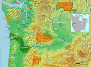
The Clackamas River is an approximately 83 miles (133.6 km) tributary of the Willamette River
in northwestern Oregon
, in the United States
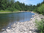
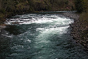
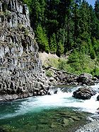
. As it drains an area of about 940 square miles (2,435 km²), the Clackamas passes through mostly forested and rugged mountainous terrain in its upper reaches, and passes through agricultural and urban areas in its lower third.
The river rises in eastern Marion County
, about 55 miles (89 km) east-southeast of Salem
. The headwaters are in the Cascades'
Mount Hood National Forest
, on the slopes of Olallie Butte
—which is about 10 miles (16 km) north of Mt. Jefferson
—at an elevation of 4909 feet (1,496 m). The Clackamas flows briefly north and then flows northwest through the mountains, passing through North Fork Reservoir and Estacada
. It then emerges from the mountains southeast of Portland
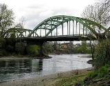
. It joins the Willamette near Oregon City
, and forms the boundary between Oregon City and Gladstone
.
The Clackamas provides hydroelectric power and drinking water for some of the Portland metropolitan area, and supports runs of Coho salmon
, spring and fall Chinook salmon
, and summer and winter steelhead
. The river's old-growth forests, its habitat for several species of birds, its healthy fish runs, and the recreational opportunities that it provides—such as fishing and whitewater rafting—led to the designation of more than half of the length of the river into the National Wild and Scenic Rivers System (NWSRS). This environment also allowed Native Americans
to settle in the river's basin as early as 10,000 years ago.
Regulation of the river began in 1905 with the Cazadero Dam
. In 1912, the River Mill Dam intercepted wood and coarse sediment. Later dams at North Fork, Oak Grove, Stone Creek, and Timothy Lake also intercepted wood sediment on the lower river.
near Olallie Butte
, between Mount Hood
and Mount Jefferson
in the Mount Hood National Forest
. Flowing generally northwest and then west for about 83 miles (133.6 km), it joins the Willamette River at Gladstone
. The river falls nearly 4900 feet (1,493.5 m) between its source and its mouth
.
Originating in Marion County
, the Clackamas River receives Squirrel Creek from the left bank and Lemiti Creek from the right bank before entering Clackamas County about 76 miles (122.3 km) from the mouth. Over its next 10 miles (16.1 km), much of which is in a relatively level stretch known as Big Bottom, the river receives Cub Creek from the left, Sisi Creek from the right, then Hunter, Fawn, Rhododendron, and Lowe creeks, all from the left, followed by Wall, Pinhead, and Campbell creeks, all from the right, Kansas Creek from the left, and Cabin Creek and Lost Creek, both from the right. About 61 miles (98.2 km) from the mouth, Granite Creek enters from the left, and the river flows by Austin Hot Springs and Picnic Area. Shortly thereafter, Switch Creek enters from the right, and at about 57 miles (91.7 km) from the mouth, the Clackamas receives the Collawash River
from the left. At the confluence, Two Rivers Picnic Area is on the left and Riverford Campground is on the right. About 1 miles (1.6 km) further downstream, Trout Creek enters from the left, and Riverside Campground is on the right.
 Shortly thereafter, Tag Creek enters from the right, and at about 53 miles (85.3 km) from the mouth, the Clackamas River receives Oak Grove Fork Clackamas River
from the right. From its confluence with Oak Grove Fork, the river runs close to Oregon Route 224 for most of the rest of its course. The highway is initially north and east of the river; that is, to its right. Over the next few miles, the river receives Big Creek, Sandstone Creek, and Whale Creek, all from the left, passes under Route 224, receives Cripple Creek, and passes under Route 224 again at the unincorporated community of Three Lynx. It receives Three Lynx Creek and Deer Creek from the right, Cat Creek from the left, and then Dinner Creek from the right as it enters a chute known as The Narrows about 46 miles (74 km) from the mouth. Soon Pup Creek enters from the left opposite the Sunstrip Campground before Roaring River enters from the right at about 44 miles (70.8 km) from the mouth. Near this point, Roaring River Campground is on the right. Shortly thereafter, Murphy Creek enters from the right, and Fish Creek enters from the left about 42 miles (67.6 km) from the mouth.
 Over the next few miles, the river flows by Fish Creek Campground and Armstrong Campground, where it passes under Route 224. The river then passes Lockaby Campground and Carter Bridge Campground, where it passes under Route 224 again for the fourth and final time. From here to near Gladstone, the river flows south and west of the highway, which is on its right. Below Carter Bridge, the Clackamas River receives Hellion Creek from the left about 40 miles (64.4 km) from the mouth, passes Big Eddy Campground, receives Moore Creek from the right, and passes Lazy Bend Campground. Around 35 miles (56.3 km) from the mouth, the river receives the South Fork Clackamas River
from the left opposite a landform
known as Big Cliff. About 2 miles (3.2 km) later, the river enters North Fork Reservoir and soon receives the North Fork Clackamas River
from the right. The Clackamas reaches the Faraday Dam, formerly known as the Cazadero Dam
, about 28 miles (45.1 km) from the mouth and passes Faraday Lake, which is on the river's left about 2 miles (3.2 km) later. Shortly thereafter, the Clackamas receives Lingleback Creek from the right, passes under Oregon Route 211 at Estacada, receives Dubois Creek from the left, and reaches River Mill Dam. It flows by Milo McIver State Park
, south of the river between 24 miles (38.6 km) and 20 miles (32.2 km) from its mouth.
The river then flows by Bonnie Lure State Recreation Area
, which lies to the north, and receives Eagle Creek from the right about 17 miles (27.4 km) from the mouth. It receives Goose Creek from the right before passing Barton County Park, which lies north of the river about 3 miles (4.8 km) downstream of Bonnie Lure. Deep Creek then enters from the right, Foster Creek from the left, and Richardson Creek from the right before the Clackamas River reaches Carver
at about 8 miles (12.9 km) from the mouth. Here it receives Clear Creek from the left. Thereafter, Rock Creek enters from the right and Johnson Creek from the left before the river passes under Interstate 205
and then Oregon Route 99E (McLoughlin Boulevard) between Oregon City
to the south and Gladstone to the north. Clackamette Park lies to the left of the river's last stretch as it enters the Willamette 25 miles (40.2 km) above its confluence with the Columbia River
.
 Before 1800, conifer
ous forests covered most of the watershed, and its streams supported big populations of salmon
, steelhead
, and other fish. Native Americans hunted, fished and gathered food and materials in the Clackamas River drainage as early as 10,000 years ago. By 2,000 to 3,000 years ago, they had established permanent settlements along the river's lower floodplain. This was home to the Clackamas Indians, a subgroup of the Chinookan
speakers who lived in the Columbia River Valley from Celilo Falls
to the Pacific Ocean. The Clackamas lands, reaching into the Cascade Range
foothills, included the lower Willamette River from Willamette Falls
at what became Oregon City
to the confluence with the Columbia.
When Lewis and Clark
visited the area in 1806, the Clackamas tribe consisted of about 1,800 people living in 11 villages. Big villages lay near the falls and the mouth of the Clackamas River; others lay near Estacada
and Eagle Creek
. In the winter, families stayed in the villages, but at other times they used an extensive system of trails to visit seasonal camps. Epidemics of smallpox
, malaria
, and measles
reduced the Clackamas population to 88 by 1851, and in 1855 the tribe surrendered its lands. Remnants of the tribe continued to travel from the Warm Springs Indian Reservation
to fish and to gather berries near Estacada through the 1930s.
, while most of the lower watershed, partly agricultural and more heavily populated, is privately owned. Private timber companies own some of the land between the national forest and the lower watershed, and some of it is public land managed by the Bureau of Land Management
. Roughly 72 percent of the watershed is on public land; 25 percent is private, and 3 percent is owned by Native American tribes. The watershed's estimated population in 1995 was 63,702.
The Clackamas River supplies drinking water to more than 200,000 people. The City of Estacada
, Clackamas River Water, the combined Oak Lodge Water District and Sunrise Water Authority, the South Fork Water Board, and the City of Lake Oswego all draw water from the Clackamas.
 Forty-seven miles (76 km) of the Clackamas River, from Big Springs to Big Cliff, are federally protected as part of the NWSRS. Of these, 20 miles (32 km) are designated as "scenic" and 27 miles (43 km) as "recreational". The protected portion of the Clackamas features five categories of resources that are considered to be "outstandingly remarkable", defined by the NWSRS as having "importance to the region or nation".
The five are opportunities for recreation such as white water rafting near the Portland metropolitan area; anadromous fish habitat supporting wild late winter coho, spring chinook
, and winter steelhead; habitat for the federally threatened Bald Eagle
and Northern Spotted Owl
and potential habitat for the threatened Peregrine Falcon
; the forests of old-growth Douglas-fir
along its banks; and historic importance. Fourteen miles (23 km) of a tributary, the Roaring River, from its headwaters to its confluence with the Clackamas River, are designated wild and scenic. In addition, 4.2 miles (6.8 km) of the South Fork Clackamas River were designated "wild" in 2009.
(USGS) released a report entitled "Pesticide Occurrence and Distribution in the Lower Clackamas River Basin, Oregon, 2000–2005." It details pesticide pollution in the lower mainstem Clackamas River, its tributaries, and in pre- and post-treatment drinking water.
The study concluded that "Given their frequent and widespread occurrence, especially during storms, pesticides have the potential to affect aquatic life and the quality of drinking water derived from the lower river," and laid out areas for further study.
Willamette River
The Willamette River is a major tributary of the Columbia River, accounting for 12 to 15 percent of the Columbia's flow. The Willamette's main stem is long, lying entirely in northwestern Oregon in the United States...
in northwestern Oregon
Oregon
Oregon is a state in the Pacific Northwest region of the United States. It is located on the Pacific coast, with Washington to the north, California to the south, Nevada on the southeast and Idaho to the east. The Columbia and Snake rivers delineate much of Oregon's northern and eastern...
, in the United States
United States
The United States of America is a federal constitutional republic comprising fifty states and a federal district...
. As it drains an area of about 940 square miles (2,435 km²), the Clackamas passes through mostly forested and rugged mountainous terrain in its upper reaches, and passes through agricultural and urban areas in its lower third.
The river rises in eastern Marion County
Marion County, Oregon
Marion County is a county located in the U.S. state of Oregon. It was originally named the Champooick District, after Champoeg, a meeting place on the Willamette River. On September 3, 1849, the territorial legislature renamed it in honor of Francis Marion, a Continental Army general of the...
, about 55 miles (89 km) east-southeast of Salem
Salem, Oregon
Salem is the capital of the U.S. state of Oregon, and the county seat of Marion County. It is located in the center of the Willamette Valley alongside the Willamette River, which runs north through the city. The river forms the boundary between Marion and Polk counties, and the city neighborhood...
. The headwaters are in the Cascades'
Cascade Range
The Cascade Range is a major mountain range of western North America, extending from southern British Columbia through Washington and Oregon to Northern California. It includes both non-volcanic mountains, such as the North Cascades, and the notable volcanoes known as the High Cascades...
Mount Hood National Forest
Mount Hood National Forest
The Mount Hood National Forest is located east of the city of Portland, Oregon, and the northern Willamette River valley. The Forest extends south from the Columbia River Gorge across more than of forested mountains, lakes and streams to the Olallie Scenic Area, a high lake basin under the slopes...
, on the slopes of Olallie Butte
Olallie Butte
Olallie Butte is a steep-sided shield volcano in the Cascade Range of northern Oregon. It is the largest volcano and highest point in the distance between Mount Hood and Mount Jefferson, Oregon's two highest peaks...
—which is about 10 miles (16 km) north of Mt. Jefferson
Mount Jefferson (Oregon)
Mount Jefferson is a stratovolcano in the Cascade Volcanic Arc, part of the Cascade Range, and is the second highest mountain in Oregon. Situated in the far northeastern corner of Linn County on the Jefferson County line, about east of Corvallis, Mount Jefferson is in a rugged wilderness and is...
—at an elevation of 4909 feet (1,496 m). The Clackamas flows briefly north and then flows northwest through the mountains, passing through North Fork Reservoir and Estacada
Estacada, Oregon
Estacada is a city in Clackamas County, Oregon, United States, about 30 miles southeast of Portland. The population was 2,695 at the 2010 census. -History:The Estacada post office opened in February 1904 and the city was incorporated in May 1905...
. It then emerges from the mountains southeast of Portland
Portland, Oregon
Portland is a city located in the Pacific Northwest, near the confluence of the Willamette and Columbia rivers in the U.S. state of Oregon. As of the 2010 Census, it had a population of 583,776, making it the 29th most populous city in the United States...
. It joins the Willamette near Oregon City
Oregon City, Oregon
Oregon City was the first city in the United States west of the Rocky Mountains to be incorporated. It is the county seat of Clackamas County, Oregon...
, and forms the boundary between Oregon City and Gladstone
Gladstone, Oregon
Gladstone is a city located in Clackamas County, Oregon, United States. As of the 2000 census, the city had a total population of 11,438. The 2007 estimate is 12,200 residents. Gladstone is a four-square-mile suburban community twelve miles south of Portland at the confluence of the Clackamas and...
.
The Clackamas provides hydroelectric power and drinking water for some of the Portland metropolitan area, and supports runs of Coho salmon
Coho salmon
The Coho salmon, Oncorhynchus kisutch, is a species of anadromous fish in the salmon family. Coho salmon are also known as silver salmon or "silvers". It is the state animal of Chiba, Japan.-Description:...
, spring and fall Chinook salmon
Chinook salmon
The Chinook salmon, Oncorhynchus tshawytscha, is the largest species in the pacific salmon family. Other commonly used names for the species include King salmon, Quinnat salmon, Spring salmon and Tyee salmon...
, and summer and winter steelhead
Rainbow trout
The rainbow trout is a species of salmonid native to tributaries of the Pacific Ocean in Asia and North America. The steelhead is a sea run rainbow trout usually returning to freshwater to spawn after 2 to 3 years at sea. In other words, rainbow trout and steelhead trout are the same species....
. The river's old-growth forests, its habitat for several species of birds, its healthy fish runs, and the recreational opportunities that it provides—such as fishing and whitewater rafting—led to the designation of more than half of the length of the river into the National Wild and Scenic Rivers System (NWSRS). This environment also allowed Native Americans
Native Americans in the United States
Native Americans in the United States are the indigenous peoples in North America within the boundaries of the present-day continental United States, parts of Alaska, and the island state of Hawaii. They are composed of numerous, distinct tribes, states, and ethnic groups, many of which survive as...
to settle in the river's basin as early as 10,000 years ago.
Regulation of the river began in 1905 with the Cazadero Dam
Cazadero Dam
Cazadero Dam was a dam on the Clackamas River, near the city of Estacada, Oregon, United States. It was destroyed by flood in 1965 and replaced with the Faraday Dam.-External links:* from University of Washington Libraries Digital Collections...
. In 1912, the River Mill Dam intercepted wood and coarse sediment. Later dams at North Fork, Oak Grove, Stone Creek, and Timothy Lake also intercepted wood sediment on the lower river.
Course
The Clackamas River arises on the western slopes of the Cascade RangeCascade Range
The Cascade Range is a major mountain range of western North America, extending from southern British Columbia through Washington and Oregon to Northern California. It includes both non-volcanic mountains, such as the North Cascades, and the notable volcanoes known as the High Cascades...
near Olallie Butte
Olallie Butte
Olallie Butte is a steep-sided shield volcano in the Cascade Range of northern Oregon. It is the largest volcano and highest point in the distance between Mount Hood and Mount Jefferson, Oregon's two highest peaks...
, between Mount Hood
Mount Hood
Mount Hood, called Wy'east by the Multnomah tribe, is a stratovolcano in the Cascade Volcanic Arc of northern Oregon. It was formed by a subduction zone and rests in the Pacific Northwest region of the United States...
and Mount Jefferson
Mount Jefferson (Oregon)
Mount Jefferson is a stratovolcano in the Cascade Volcanic Arc, part of the Cascade Range, and is the second highest mountain in Oregon. Situated in the far northeastern corner of Linn County on the Jefferson County line, about east of Corvallis, Mount Jefferson is in a rugged wilderness and is...
in the Mount Hood National Forest
Mount Hood National Forest
The Mount Hood National Forest is located east of the city of Portland, Oregon, and the northern Willamette River valley. The Forest extends south from the Columbia River Gorge across more than of forested mountains, lakes and streams to the Olallie Scenic Area, a high lake basin under the slopes...
. Flowing generally northwest and then west for about 83 miles (133.6 km), it joins the Willamette River at Gladstone
Gladstone, Oregon
Gladstone is a city located in Clackamas County, Oregon, United States. As of the 2000 census, the city had a total population of 11,438. The 2007 estimate is 12,200 residents. Gladstone is a four-square-mile suburban community twelve miles south of Portland at the confluence of the Clackamas and...
. The river falls nearly 4900 feet (1,493.5 m) between its source and its mouth
River delta
A delta is a landform that is formed at the mouth of a river where that river flows into an ocean, sea, estuary, lake, reservoir, flat arid area, or another river. Deltas are formed from the deposition of the sediment carried by the river as the flow leaves the mouth of the river...
.
Originating in Marion County
Marion County, Oregon
Marion County is a county located in the U.S. state of Oregon. It was originally named the Champooick District, after Champoeg, a meeting place on the Willamette River. On September 3, 1849, the territorial legislature renamed it in honor of Francis Marion, a Continental Army general of the...
, the Clackamas River receives Squirrel Creek from the left bank and Lemiti Creek from the right bank before entering Clackamas County about 76 miles (122.3 km) from the mouth. Over its next 10 miles (16.1 km), much of which is in a relatively level stretch known as Big Bottom, the river receives Cub Creek from the left, Sisi Creek from the right, then Hunter, Fawn, Rhododendron, and Lowe creeks, all from the left, followed by Wall, Pinhead, and Campbell creeks, all from the right, Kansas Creek from the left, and Cabin Creek and Lost Creek, both from the right. About 61 miles (98.2 km) from the mouth, Granite Creek enters from the left, and the river flows by Austin Hot Springs and Picnic Area. Shortly thereafter, Switch Creek enters from the right, and at about 57 miles (91.7 km) from the mouth, the Clackamas receives the Collawash River
Collawash River
The Collawash River is a tributary of the Clackamas River in the U.S. state of Oregon. Formed by the confluence of Elk Lake Creek and the East Fork Collawash River in the Cascade Range, it flows generally north-northwest from source to mouth through the Mount Hood National Forest. The largest...
from the left. At the confluence, Two Rivers Picnic Area is on the left and Riverford Campground is on the right. About 1 miles (1.6 km) further downstream, Trout Creek enters from the left, and Riverside Campground is on the right.
Oak Grove Fork Clackamas River
Oak Grove Fork Clackamas River is a tributary of the Clackamas River in the U.S. state of Oregon. From its headwaters in the Warm Springs Indian Reservation near Abbot Pass in the Cascade Range, the river flows generally west through Mount Hood National Forest in Clackamas County to the...
from the right. From its confluence with Oak Grove Fork, the river runs close to Oregon Route 224 for most of the rest of its course. The highway is initially north and east of the river; that is, to its right. Over the next few miles, the river receives Big Creek, Sandstone Creek, and Whale Creek, all from the left, passes under Route 224, receives Cripple Creek, and passes under Route 224 again at the unincorporated community of Three Lynx. It receives Three Lynx Creek and Deer Creek from the right, Cat Creek from the left, and then Dinner Creek from the right as it enters a chute known as The Narrows about 46 miles (74 km) from the mouth. Soon Pup Creek enters from the left opposite the Sunstrip Campground before Roaring River enters from the right at about 44 miles (70.8 km) from the mouth. Near this point, Roaring River Campground is on the right. Shortly thereafter, Murphy Creek enters from the right, and Fish Creek enters from the left about 42 miles (67.6 km) from the mouth.
South Fork Clackamas River
The South Fork Clackamas River is a tributary, roughly long, of the Clackamas River in the U.S. state of Oregon. Beginning near South Fork Mountain in the western Cascade Range, the river flows generally north through Clackamas County to meet the larger river at Big Cliff...
from the left opposite a landform
Landform
A landform or physical feature in the earth sciences and geology sub-fields, comprises a geomorphological unit, and is largely defined by its surface form and location in the landscape, as part of the terrain, and as such, is typically an element of topography...
known as Big Cliff. About 2 miles (3.2 km) later, the river enters North Fork Reservoir and soon receives the North Fork Clackamas River
North Fork Clackamas River
The North Fork Clackamas River is a tributary, about long, of the Clackamas River in the U.S. state of Oregon. Originating at nearly above sea level on the west side of the Cascade Range, it flows westward through Mount Hood National Forest. It joins the Clackamas at North Fork Reservoir, about ...
from the right. The Clackamas reaches the Faraday Dam, formerly known as the Cazadero Dam
Cazadero Dam
Cazadero Dam was a dam on the Clackamas River, near the city of Estacada, Oregon, United States. It was destroyed by flood in 1965 and replaced with the Faraday Dam.-External links:* from University of Washington Libraries Digital Collections...
, about 28 miles (45.1 km) from the mouth and passes Faraday Lake, which is on the river's left about 2 miles (3.2 km) later. Shortly thereafter, the Clackamas receives Lingleback Creek from the right, passes under Oregon Route 211 at Estacada, receives Dubois Creek from the left, and reaches River Mill Dam. It flows by Milo McIver State Park
Milo McIver State Park
Milo McIver State Park is a state park in the U.S. state of Oregon. It is located in Clackamas County, along the Clackamas River, near Estacada and close to Mount Hood...
, south of the river between 24 miles (38.6 km) and 20 miles (32.2 km) from its mouth.
The river then flows by Bonnie Lure State Recreation Area
Bonnie Lure State Recreation Area
Bonnie Lure State Recreation Area is a state park in the U.S. state of Oregon, administered by the Oregon Parks and Recreation Department....
, which lies to the north, and receives Eagle Creek from the right about 17 miles (27.4 km) from the mouth. It receives Goose Creek from the right before passing Barton County Park, which lies north of the river about 3 miles (4.8 km) downstream of Bonnie Lure. Deep Creek then enters from the right, Foster Creek from the left, and Richardson Creek from the right before the Clackamas River reaches Carver
Carver, Oregon
Carver is an unincorporated community in Clackamas County, Oregon, United States, which as of 2004, is part of the city of Damascus, Oregon. Before 2004, when the city of Damascus incorporated, Carver was an independent, unincorporated community...
at about 8 miles (12.9 km) from the mouth. Here it receives Clear Creek from the left. Thereafter, Rock Creek enters from the right and Johnson Creek from the left before the river passes under Interstate 205
Interstate 205 (Oregon-Washington)
Interstate 205 is a loop route that serves the Portland—Vancouver metropolitan area in the U.S. states of Oregon and Washington. I-205 is officially named the War Veterans Memorial Freeway, and is also known as the East Portland Freeway...
and then Oregon Route 99E (McLoughlin Boulevard) between Oregon City
Oregon City, Oregon
Oregon City was the first city in the United States west of the Rocky Mountains to be incorporated. It is the county seat of Clackamas County, Oregon...
to the south and Gladstone to the north. Clackamette Park lies to the left of the river's last stretch as it enters the Willamette 25 miles (40.2 km) above its confluence with the Columbia River
Columbia River
The Columbia River is the largest river in the Pacific Northwest region of North America. The river rises in the Rocky Mountains of British Columbia, Canada, flows northwest and then south into the U.S. state of Washington, then turns west to form most of the border between Washington and the state...
.
Early inhabitants
Pinophyta
The conifers, division Pinophyta, also known as division Coniferophyta or Coniferae, are one of 13 or 14 division level taxa within the Kingdom Plantae. Pinophytes are gymnosperms. They are cone-bearing seed plants with vascular tissue; all extant conifers are woody plants, the great majority being...
ous forests covered most of the watershed, and its streams supported big populations of salmon
Salmon
Salmon is the common name for several species of fish in the family Salmonidae. Several other fish in the same family are called trout; the difference is often said to be that salmon migrate and trout are resident, but this distinction does not strictly hold true...
, steelhead
Rainbow trout
The rainbow trout is a species of salmonid native to tributaries of the Pacific Ocean in Asia and North America. The steelhead is a sea run rainbow trout usually returning to freshwater to spawn after 2 to 3 years at sea. In other words, rainbow trout and steelhead trout are the same species....
, and other fish. Native Americans hunted, fished and gathered food and materials in the Clackamas River drainage as early as 10,000 years ago. By 2,000 to 3,000 years ago, they had established permanent settlements along the river's lower floodplain. This was home to the Clackamas Indians, a subgroup of the Chinookan
Chinookan languages
Chinookan is a small family of languages spoken in Oregon and Washington along the Columbia River by Chinook peoples.-Family division:Chinookan languages consists of three languages with multiple varieties. There is some dispute over classification, and there are two ISO 639-3 codes assigned: and...
speakers who lived in the Columbia River Valley from Celilo Falls
Celilo Falls
Celilo Falls was a tribal fishing area on the Columbia River, just east of the Cascade Mountains, on what is today the border between the U.S. states of Oregon and Washington...
to the Pacific Ocean. The Clackamas lands, reaching into the Cascade Range
Cascade Range
The Cascade Range is a major mountain range of western North America, extending from southern British Columbia through Washington and Oregon to Northern California. It includes both non-volcanic mountains, such as the North Cascades, and the notable volcanoes known as the High Cascades...
foothills, included the lower Willamette River from Willamette Falls
Willamette Falls
The Willamette Falls is a natural waterfall on the Willamette River between Oregon City and West Linn, Oregon, in the United States. It is the largest waterfall in the Pacific Northwest and the eighteenth largest in the world by water volume. Horseshoe in shape, it is wide and high with a flow...
at what became Oregon City
Oregon City, Oregon
Oregon City was the first city in the United States west of the Rocky Mountains to be incorporated. It is the county seat of Clackamas County, Oregon...
to the confluence with the Columbia.
When Lewis and Clark
Lewis and Clark Expedition
The Lewis and Clark Expedition, or ″Corps of Discovery Expedition" was the first transcontinental expedition to the Pacific Coast by the United States. Commissioned by President Thomas Jefferson and led by two Virginia-born veterans of Indian wars in the Ohio Valley, Meriwether Lewis and William...
visited the area in 1806, the Clackamas tribe consisted of about 1,800 people living in 11 villages. Big villages lay near the falls and the mouth of the Clackamas River; others lay near Estacada
Estacada, Oregon
Estacada is a city in Clackamas County, Oregon, United States, about 30 miles southeast of Portland. The population was 2,695 at the 2010 census. -History:The Estacada post office opened in February 1904 and the city was incorporated in May 1905...
and Eagle Creek
Eagle Creek, Oregon
Eagle Creek is an unincorporated community in Clackamas County, Oregon, United States. It is located seven miles southwest of Sandy, seven miles north of Estacada, and five miles southeast of Carver, at the junction of Oregon Routes 224 and 211, on the Clackamas River.-Background and history:The...
. In the winter, families stayed in the villages, but at other times they used an extensive system of trails to visit seasonal camps. Epidemics of smallpox
Smallpox
Smallpox was an infectious disease unique to humans, caused by either of two virus variants, Variola major and Variola minor. The disease is also known by the Latin names Variola or Variola vera, which is a derivative of the Latin varius, meaning "spotted", or varus, meaning "pimple"...
, malaria
Malaria
Malaria is a mosquito-borne infectious disease of humans and other animals caused by eukaryotic protists of the genus Plasmodium. The disease results from the multiplication of Plasmodium parasites within red blood cells, causing symptoms that typically include fever and headache, in severe cases...
, and measles
Measles
Measles, also known as rubeola or morbilli, is an infection of the respiratory system caused by a virus, specifically a paramyxovirus of the genus Morbillivirus. Morbilliviruses, like other paramyxoviruses, are enveloped, single-stranded, negative-sense RNA viruses...
reduced the Clackamas population to 88 by 1851, and in 1855 the tribe surrendered its lands. Remnants of the tribe continued to travel from the Warm Springs Indian Reservation
Warm Springs Indian Reservation
The Warm Springs Indian Reservation consists of 1,019.385 sq mi in north central Oregon, in the United States, and is occupied and governed by the Confederated Tribes of Warm Springs.-Tribes:...
to fish and to gather berries near Estacada through the 1930s.
Watershed
The river basin, made up of 16 subwatersheds, drains an area of about 940 mi2.Most of the upper half of the basin lies in rugged, heavily forested terrain within the Mount Hood National Forest, managed by the U.S. Forest ServiceUnited States Forest Service
The United States Forest Service is an agency of the United States Department of Agriculture that administers the nation's 155 national forests and 20 national grasslands, which encompass...
, while most of the lower watershed, partly agricultural and more heavily populated, is privately owned. Private timber companies own some of the land between the national forest and the lower watershed, and some of it is public land managed by the Bureau of Land Management
Bureau of Land Management
The Bureau of Land Management is an agency within the United States Department of the Interior which administers America's public lands, totaling approximately , or one-eighth of the landmass of the country. The BLM also manages of subsurface mineral estate underlying federal, state and private...
. Roughly 72 percent of the watershed is on public land; 25 percent is private, and 3 percent is owned by Native American tribes. The watershed's estimated population in 1995 was 63,702.
The Clackamas River supplies drinking water to more than 200,000 people. The City of Estacada
Estacada, Oregon
Estacada is a city in Clackamas County, Oregon, United States, about 30 miles southeast of Portland. The population was 2,695 at the 2010 census. -History:The Estacada post office opened in February 1904 and the city was incorporated in May 1905...
, Clackamas River Water, the combined Oak Lodge Water District and Sunrise Water Authority, the South Fork Water Board, and the City of Lake Oswego all draw water from the Clackamas.
Wild and scenic
The five are opportunities for recreation such as white water rafting near the Portland metropolitan area; anadromous fish habitat supporting wild late winter coho, spring chinook
Chinook salmon
The Chinook salmon, Oncorhynchus tshawytscha, is the largest species in the pacific salmon family. Other commonly used names for the species include King salmon, Quinnat salmon, Spring salmon and Tyee salmon...
, and winter steelhead; habitat for the federally threatened Bald Eagle
Bald Eagle
The Bald Eagle is a bird of prey found in North America. It is the national bird and symbol of the United States of America. This sea eagle has two known sub-species and forms a species pair with the White-tailed Eagle...
and Northern Spotted Owl
Northern Spotted Owl
The Northern Spotted Owl, Strix occidentalis caurina, is one of three Spotted Owl subspecies. A Western North American bird in the family Strigidae, genus Strix, it is a medium-sized dark brown owl sixteen to nineteen inches in length and one to one and one sixth pounds. Females are larger than males...
and potential habitat for the threatened Peregrine Falcon
Peregrine Falcon
The Peregrine Falcon , also known as the Peregrine, and historically as the Duck Hawk in North America, is a widespread bird of prey in the family Falconidae. A large, crow-sized falcon, it has a blue-gray back, barred white underparts, and a black head and "moustache"...
; the forests of old-growth Douglas-fir
Douglas-fir
Douglas-fir is one of the English common names for evergreen coniferous trees of the genus Pseudotsuga in the family Pinaceae. Other common names include Douglas tree, and Oregon pine. There are five species, two in western North America, one in Mexico, and two in eastern Asia...
along its banks; and historic importance. Fourteen miles (23 km) of a tributary, the Roaring River, from its headwaters to its confluence with the Clackamas River, are designated wild and scenic. In addition, 4.2 miles (6.8 km) of the South Fork Clackamas River were designated "wild" in 2009.
Pollution
In March 2008, the United States Geological SurveyUnited States Geological Survey
The United States Geological Survey is a scientific agency of the United States government. The scientists of the USGS study the landscape of the United States, its natural resources, and the natural hazards that threaten it. The organization has four major science disciplines, concerning biology,...
(USGS) released a report entitled "Pesticide Occurrence and Distribution in the Lower Clackamas River Basin, Oregon, 2000–2005." It details pesticide pollution in the lower mainstem Clackamas River, its tributaries, and in pre- and post-treatment drinking water.
In all, 63 pesticide compounds: 33 herbicides, 15 insecticides, 6 fungicides, and 9 pesticide degradates were detected in samples collected during storm and nonstorm conditions. Fifty-seven pesticides or degradates were detected in the tributaries (mostly during storms), whereas fewer compounds (26) were detected in samples of source water from the lower mainstem Clackamas River, with fewest (15) occurring in drinking water.
The study concluded that "Given their frequent and widespread occurrence, especially during storms, pesticides have the potential to affect aquatic life and the quality of drinking water derived from the lower river," and laid out areas for further study.
See also
- Clackamas (disambiguation)
- List of rivers of Oregon
- List of longest streams of Oregon
- List of National Wild and Scenic Rivers
External links
- Clackamas River Basin Council
- Student Watershed Research Project (SWRP): Clackamas River watershed map
- "Tests find some pesticides in lower Clackamas River" by Scott Learn, The Oregonian, March 17, 2008