

Petawawa River
Encyclopedia
The Petawawa River is a river
in the Saint Lawrence River
drainage basin
in Nipissing District and Renfrew County in eastern
and northeastern
Ontario
, Canada
. The river flows from Algonquin Provincial Park
to the Ottawa River
at the town of Petawawa. The river's name comes from the Algonquian
for "where one hears a noise like this", which refers to its many rapids.
then east to Big Trout Lake. The river heads north out the lake over Big Trout Lake Dam, takes in the left tributary Tim River
, flows over the Portal Rapids, Cedar Rapids, Showshoe Rapids, Catfish Rapids, and Stacks Rapids to reach Cedar Lake, the location of the community of Brent
, where it takes in the left tributary Nipissing River
. The river exits the lake over a dam, heads through the Devil's Chute, reaches Radiant Lake, where it takes in the left tributary North River
and right tributary Little Madawaska River
, and passes through the Squirrel Rapids, Big Sawyer Rapids, Battery Rapids Cascade Rapids and White Horse Rapids, and takes in the right tributary Crow River
. The river then continues through a series of rapids including the Devil's Cellar Rapids, passes the Algonquin Radio Observatory
, and reaches Lake Travers. The Petawawa River enters a canyon and passes through numerous rapids including the Big Thompson Rapids, Little Thompson Rapids, Grillade Rapids, Crooked Chute, Rollway Rapids, The Natch, Schoooner Rapids, Five Mile Rapids to arrive at Whitson Lake adjacent to the Petawawa Hills. It leaves Algonquin Provincial Park and enters the municipality of Laurentian Hills in Renfrew County, continues southeast past CFB Petawawa
, passes through the Crooked Rapids, Race Horse Rapids, White Horse Rapids and Halfmile Rapids, and reaches Lac du Bois Dur, where it takes in the right tributary Barron River
. The river enters the town of Petawawa, heads under Ontario Highway 17, through the Big Eddy Rapids, under the Canadian Pacific Railway
main line
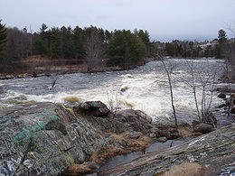
, and empties into Black Bay on the Ottawa River.
The river is 187 kilometres (116.2 mi) in length and drains an area of 4200 square kilometres (1,621.6 sq mi), with a mean discharge of 45 cubic metres (1,589 cu ft) per second.
of the timber
from the forested areas surrounding the river. The river is popular among canoe
ing and kayak
ing enthusiasts for its white water rapids and often spectacular views.
, a 175 million year old rift valley
.
River
A river is a natural watercourse, usually freshwater, flowing towards an ocean, a lake, a sea, or another river. In a few cases, a river simply flows into the ground or dries up completely before reaching another body of water. Small rivers may also be called by several other names, including...
in the Saint Lawrence River
Saint Lawrence River
The Saint Lawrence is a large river flowing approximately from southwest to northeast in the middle latitudes of North America, connecting the Great Lakes with the Atlantic Ocean. It is the primary drainage conveyor of the Great Lakes Basin...
drainage basin
Drainage basin
A drainage basin is an extent or an area of land where surface water from rain and melting snow or ice converges to a single point, usually the exit of the basin, where the waters join another waterbody, such as a river, lake, reservoir, estuary, wetland, sea, or ocean...
in Nipissing District and Renfrew County in eastern
Eastern Ontario
Eastern Ontario is a subregion of Southern Ontario in the Canadian province of Ontario which lies in a wedge-shaped area between the Ottawa River and St. Lawrence River...
and northeastern
Northeastern Ontario
Northeastern Ontario is the region within the Canadian province of Ontario which lies north and east of Lakes Superior and Huron.Northeastern Ontario consists of the districts of Algoma, Sudbury, Cochrane, Timiskaming, Nipissing and Manitoulin; and the single-tier municipality of Greater...
Ontario
Ontario
Ontario is a province of Canada, located in east-central Canada. It is Canada's most populous province and second largest in total area. It is home to the nation's most populous city, Toronto, and the nation's capital, Ottawa....
, Canada
Canada
Canada is a North American country consisting of ten provinces and three territories. Located in the northern part of the continent, it extends from the Atlantic Ocean in the east to the Pacific Ocean in the west, and northward into the Arctic Ocean...
. The river flows from Algonquin Provincial Park
Algonquin Provincial Park
Algonquin Provincial Park is a provincial park located between Georgian Bay and the Ottawa River in Central Ontario, Canada, mostly within the Unorganized South Part of Nipissing District. Established in 1893, it is the oldest provincial park in Canada. Additions since its creation have increased...
to the Ottawa River
Ottawa River
The Ottawa River is a river in the Canadian provinces of Ontario and Quebec. For most of its length, it now defines the border between these two provinces.-Geography:...
at the town of Petawawa. The river's name comes from the Algonquian
Algonquian languages
The Algonquian languages also Algonkian) are a subfamily of Native American languages which includes most of the languages in the Algic language family. The name of the Algonquian language family is distinguished from the orthographically similar Algonquin dialect of the Ojibwe language, which is a...
for "where one hears a noise like this", which refers to its many rapids.
Course
The river starts at Ralph Bice Lake (formally Butt Lake) in northern Algonquin Provincial Park in the geographic township of Butt in the Unorganized South Part of Nipissing District. It flows south to Daisy LakeDaisy Lake (Nipissing District, Ontario)
Daisy Lake is a lake in the geographic townships of Butt and McCraney in the Unorganized South Part of Nipissing District, Ontario, Canada. The lake is in the Ottawa River drainage basin and is entirely within Algonquin Provincial Park....
then east to Big Trout Lake. The river heads north out the lake over Big Trout Lake Dam, takes in the left tributary Tim River
Tim River
The Tim River is a river in the Saint Lawrence River drainage basin in the Unorganized South Part of Nipissing District in northeastern Ontario, Canada...
, flows over the Portal Rapids, Cedar Rapids, Showshoe Rapids, Catfish Rapids, and Stacks Rapids to reach Cedar Lake, the location of the community of Brent
Brent, Ontario
Brent is a community on Cedar Lake on the Petawawa River in northern Algonquin Provincial Park, and is located in geographic Deacon Township in the Unorganized south part of Nipissing District in northeastern Ontario, Canada....
, where it takes in the left tributary Nipissing River
Nipissing River
The Nipissing River is a river in the Saint Lawrence River drainage basin in the Unorganized South Part of Nipissing District in northeastern Ontario, Canada...
. The river exits the lake over a dam, heads through the Devil's Chute, reaches Radiant Lake, where it takes in the left tributary North River
North River (Ontario)
North River may refer to one of five rivers in Ontario, Canada:*North River in Kenora District, in the Hudson Bay drainage basin, which flows into Marchington Lake on the Marchington River near the unincorporated place of Ghost River*In Nipissing District:...
and right tributary Little Madawaska River
Little Madawaska River (Ontario)
The Little Madawaska River is a river in the Saint Lawrence River drainage basin in the Unorganized South Part of Nipissing District in northeastern Ontario, Canada...
, and passes through the Squirrel Rapids, Big Sawyer Rapids, Battery Rapids Cascade Rapids and White Horse Rapids, and takes in the right tributary Crow River
Crow River (Ontario)
The Crow River is a river in the Saint Lawrence River drainage basin in the Unorganized South Part of Nipissing District in northeastern Ontario, Canada...
. The river then continues through a series of rapids including the Devil's Cellar Rapids, passes the Algonquin Radio Observatory
Algonquin Radio Observatory
The Algonquin Radio Observatory is a radio telescope research facility located in the Algonquin Provincial Park in Ontario, Canada. The site's primary instrument is a major 46 m parabolic-dish radio antenna. This instrument is historically famous for taking part in the first successful very...
, and reaches Lake Travers. The Petawawa River enters a canyon and passes through numerous rapids including the Big Thompson Rapids, Little Thompson Rapids, Grillade Rapids, Crooked Chute, Rollway Rapids, The Natch, Schoooner Rapids, Five Mile Rapids to arrive at Whitson Lake adjacent to the Petawawa Hills. It leaves Algonquin Provincial Park and enters the municipality of Laurentian Hills in Renfrew County, continues southeast past CFB Petawawa
CFB Petawawa
Canadian Forces Base Petawawa, commonly referred to as CFB Petawawa, or simply "Pet", is a Canadian Forces Base located in Petawawa, Ontario. It is operated as an army base by Canadian Forces Land Force Command.-Base facts:...
, passes through the Crooked Rapids, Race Horse Rapids, White Horse Rapids and Halfmile Rapids, and reaches Lac du Bois Dur, where it takes in the right tributary Barron River
Barron River (Ontario)
The Barron River is a river in the Saint Lawrence River drainage basin in Nipissing District and Renfrew County, Ontario, Canada...
. The river enters the town of Petawawa, heads under Ontario Highway 17, through the Big Eddy Rapids, under the Canadian Pacific Railway
Canadian Pacific Railway
The Canadian Pacific Railway , formerly also known as CP Rail between 1968 and 1996, is a historic Canadian Class I railway founded in 1881 and now operated by Canadian Pacific Railway Limited, which began operations as legal owner in a corporate restructuring in 2001...
main line
Main line (railway)
The Mainline or Main line of a railway is a track that is used for through trains or is the principal artery of the system from which branch lines, yards, sidings and spurs are connected....
, and empties into Black Bay on the Ottawa River.
The river is 187 kilometres (116.2 mi) in length and drains an area of 4200 square kilometres (1,621.6 sq mi), with a mean discharge of 45 cubic metres (1,589 cu ft) per second.
Economy
From the late 19th century until the 1960s, the river was used for log drivingLog driving
Log driving is a means of log transport which makes use of a river's current to move floating tree trunks downstream to sawmills and pulp mills.It was the main transportation method of the early logging industry in Europe and North America...
of the timber
Timber
Timber may refer to:* Timber, a term common in the United Kingdom and Australia for wood materials * Timber, Oregon, an unincorporated community in the U.S...
from the forested areas surrounding the river. The river is popular among canoe
Canoe
A canoe or Canadian canoe is a small narrow boat, typically human-powered, though it may also be powered by sails or small electric or gas motors. Canoes are usually pointed at both bow and stern and are normally open on top, but can be decked over A canoe (North American English) or Canadian...
ing and kayak
Kayak
A kayak is a small, relatively narrow, human-powered boat primarily designed to be manually propelled by means of a double blade paddle.The traditional kayak has a covered deck and one or more cockpits, each seating one paddler...
ing enthusiasts for its white water rapids and often spectacular views.
Geology
Part of the Petawawa River lies in the Ottawa-Bonnechere GrabenOttawa-Bonnechere Graben
The Ottawa-Bonnechere Graben , with its branch the Timiskaming Graben, is an ancient rift valley in the Canadian Shield of Northeastern Ontario and Quebec, Canada. This rift valley was formed when the Earth's crust moved downward about a kilometre between two major fault zones known as the Mattawa...
, a 175 million year old rift valley
Rift valley
A rift valley is a linear-shaped lowland between highlands or mountain ranges created by the action of a geologic rift or fault. This action is manifest as crustal extension, a spreading apart of the surface which is subsequently further deepened by the forces of erosion...
.
Tributaries
- Jorgens Creek (left)
- Lac du Bois Dur
- Charlebois Creek (left)
- Barron River (right)
- Black Bay Creek (right)
- Centre Creek (left)
- Black Duck Creek (left)
- Lorne Creek (right)
- Military Creek (left)
- Cartier Creek (left)
- Louie Creek (left)
- Emma Creek (right)
- Blue Beech Creek (left)
- Clouthier Creek (right)
- North Rouge Creek (left)
- Lake Travers
- Otterpaw Creek (left)
- Deerhorn Creek (left)
- Travers Creek (right)
- Whitson Creek (right)
- Eustache Creek (right)
- Wagtail Creek (right)
- Crow River (right)
- Pauguk Creek (right)
- Battery Creek (right)
- Plover Creek (left)
- Radiant Lake
- Menona Creek (left)
- North River (left)
- Little Madawaska River (right)
- George Creek (left)
- Cedar Lake
- Nipissing River (left)
- Cauchon Creek (left)
- Gilmour Creek (left)
- Peboan Creek (left)
- Ghost Creek (left)
- Wendigoes Creek (right)
- Pukina Creek (right)
- Sunfish Creek (right)
- Pugwa Creek (right)
- Haydes Creek (left)
- Minnehaha Creek (left)
- Spiza Creek (right)
- Alder Creek (left)
- Tim River (left)
- Mire Creek (left)
- Otterslide Creek (right)
- Dan Creek (right)
- She Creek (right)
- Timberwolf Creek (right)
- Wenona Creek (right)
- Mack Creek (left)
- Daisy Lake
- Hambone Creek (right)
- Casey Creek (right)