

Kern River
Encyclopedia
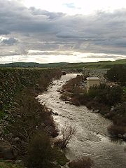
The Kern River is a river in the U.S. state
of California
, approximately 165 miles (265.5 km) long. It drains an area of the southern Sierra Nevada mountains northeast of Bakersfield
. Fed by snowmelt near Mount Whitney
, the river passes through scenic canyons in the mountains and is a popular destination for whitewater rafting and kayaking
. It is the only major river in the Sierra Nevada mountain range that drains in a southerly direction.
The Kern River formerly emptied into now dry Kern Lake via the Kern River Slough
and Kern Lake in turn emptied into Buena Vista Lake via the Buena Vista Slough at the southern end of the Central Valley
. Buena Vista Lake in turn when overflowing, drained into Tulare Lake
via a series of slough
s. They were part of a partially endorheic basin that sometimes overflowed into the San Joaquin River
. This basin also included the Kaweah
and Tule River
s as well as southern distributaries
of the Kings
.
Since the late 19th century the Kern has been almost entirely diverted for irrigation, recharging aquifers and the California Aqueduct
, although some water empties into Lake Webb and Lake Evans, two small lakes in a portion of the former Buena Vista Lakebed. The lakes were created in 1973 for recreational use. The lakes hold 6800 acre.ft combined. Crops are grown in the rest of the former lakebed. In extremely wet years the river will reach the Tulare Lake
basin through a series of sloughs and flood channels.
. It begins in the Sierra Nevada on the eastern side of Tulare County and ends on the west side of Kern County where it is mainly diverted for local water supplies. The main branch of the river (sometimes called the North Fork Kern River) rises from several small lakes west of Mount Whitney
in the high Sierra Nevada mountains in northeastern Tulare County
, in the northeast corner of Sequoia National Park
. It flows south through the mountains, passing through Inyo
and Sequoia
national forests, and the Golden Trout Wilderness
. The Little Kern River joins from the northwest at a site called Forks of the Kern.
At Kernville
the river emerges from its narrow canyon into a widening valley where it is impounded in Lake Isabella
, a reservoir formed by Isabella Dam. The area was once known as Whiskey Flat, the former location of the town of Kernville. The South Fork Kern River
joins in Lake Isabella. Like the North Fork, the South Fork rises in Tulare County and flows mainly south, through Inyo National Forest. After entering Kern County the South Fork curves to the west and flows into Lake Isabella.
Below Isabella Dam the Kern River flows southwest through a spectacular rugged canyon along the south edge of the Greenhorn Mountains
, emerging from mountains east of Bakersfield
, the largest city on the river. In the Kern's lower course downstream from Bakersfield the river is highly diverted through a series of canals to irrigate the farms of the southern San Joaquin Valley
and provide municipal water supplies to the City of Bakersfield and surrounding areas. In this region near Bakersfield the Kern River once spread out into vast wetlands and seasonal lakes.
The Friant-Kern Canal
, constructed as part of the Central Valley Project, joins the river about four miles (6 km) west of downtown Bakersfield.
The Kern River is one of the very few rivers in the Central Valley which does not contribute water to the Central Valley Project
(CVP). However, water from the CVP, mainly the Friant-Kern Canal, will be deposited for water storage in the aquifers.
Historically, the river flowed an additional 20 miles (32.2 km) south through a now-dry distributary
to Arvin
, where it formed the seasonal Kern Lake, which would grow to cover about 8300 acres (33.6 km²) during wet periods. Water from Kern Lake would then flow west through Buena Vista Slough into Lake Buena Vista, another seasonal lake that reached sizes of about 4000 acres (16.2 km²). Another channel of the Kern River flowed from the Bakersfield area southwest directly to Buena Vista Lake. In periods of high runoff, Buena Vista Lake overflowed and joined other wetlands and seasonal lakes in a series of sloughs that drained north into the former Tulare Lake
, which would sometimes overflow into the San Joaquin River
via Berenda Slough, forming one of the longest river systems in California at 535 miles (861 km).
 The river was named by John C. Frémont
in honor of Edward M. Kern
in 1845 who, as the story goes, nearly drowned in the turbulent waters. Kern was the topographer
of Fremont's third expedition through the American West. Before this, the Kern River was known as the "Rio de San Felipe" as named by Spanish missionary explorer Fr. Francisco Garcés
when he explored the Bakersfield area on May 1, 1776. On August 2, 1806, Padre Zavidea renamed the river La Porciuncula for the day of the Porciuncula Indulgence. It was locally known as Po-sun-co-la until its renaming by Fremont.
Gold
was discovered along the upper river in 1853. The snowmelt that fed the river resulted in periodic torrential flooding in Bakersfield until the construction of the Isabella Dam in the 1950s. These floods would periodically change the channel of the river. Since the establishment of Kern County in 1866 the main channel has flowed through what is the main part of downtown Bakersfield along Truxtun Avenue and again made a south turn along what is Old River Road. Many of the irrigation canals that flow in a southerly direction from the river follow the old channels of the Kern River, especially the canal that flows along Old River Road. The irrigated region of the Central Valley near the river supports the cultivation of alfalfa
, carrots, fruit, and cotton
, cattle grazing, and many other year-round crops. In 1987 the United States Congress
designated 151 mi (240 km) of the Kern's North (Main) Fork and South Fork as a National Wild and Scenic River
.
The Great 1857 Fort Tejon earthquake
on January 9, 1857 with an estimated magnitude of 7.9 on the San Andreas Fault
was strong enough to temporarily switch the direction of the flow of the Kern River. Fish in the now dry Tulare Lake
were left stranded on the shores.
In recent years the river has become controversial because of attempts by the City of Bakersfield to retain water in the river channel all year round for recreation and the recharging of the water tables from which it draws its drinking water supply. The attempts have resulted in conflicts with established agricultural interests in the Central Valley which depend heavily on the river as a supply of irrigation water. However, the river recently has been allowed to flow its normal dry course due to structural problems in the Isabella Dam. The increased flow reduces stress on the dam.
(Oncorhynchus mykiss ssp.), which are native to the Kern River tributaries South Fork Kern River
and Golden Trout Creek, and the latter's tributary, Volcano Creek.
After public outcry, the City of Bakersfield and the California Department of Fish and Game
(CDFG) decided to relocate a family of California Golden beaver (Castor canadensis subauratus) instead of killing them. California Golden beaver were native to the Central Valley and throughout the Sierra Nevada
. Specifically to the Kern watershed, an oral history was taken from Roy De Voe, who claimed to have seen "very old beaver sign" on the east side of the Kern River at Funston Meadow (elevation 6,476 feet) in 1946. Also, Mr. De Voe reported that his friend Kenny Keelor trapped the Kern River for beaver around 1900, making his camp at the mouth of Rattlesnake Creek (elevation 6,585) until they were trapped out completely by 1910 - 1914. The presence of Beaver Canyon Creek, tributary to the lower Kern River just east of Delonegha Hot Springs, is also consistent with the Kern River watershed having historically supported native beaver. This oral history is consistent with another oral history taken one watershed to the north by CDFG's Donald T. Tappe from a retired game warden in 1940, who stated that beaver were "apparently not uncommon on the upper part of the Kings River
" until 1882-1883. Currently, there are large numbers of beaver in the Ramshaw Meadows on the South Fork Kern River where their dams are trapping sediment, forming extensive pools, accelerating meadow restoration, and increasing riparian willow habitat.
runs the length of the canyon.
The Kern River Oil Field
is adjacent to the river on the north, just before the river flows into Bakersfield. The large oil field, on low hills which rise gradually into the Sierra foothills, formerly allowed much of its produced water to drain directly south into the river. However, modern environmental regulation ended this practice, and the contaminated water is now cleaned at water treatment plants and used to irrigate farms in the valley to the west.
the Kern River's discharge
changes considerably over its length. The highest mean annual flows occur just downriver of Isabella Dam, but because the dam serves to regulate the flow of water the highest daily discharges occur above the dam on the North Fork section of the Kern River. The USGS stream gage on the North Fork Kern River has recorded an average annual mean discharge of 806 cuft/s and a maximum daily discharge of 33600 cuft/s, and the gage on the South Fork Kern River shows an average annual mean of 123 cuft/s and a maximum daily discharge of 14000 cuft/s. In contrast the first stream gage below Isabella Dam has recorded an average annual mean of 946 cuft/s but a maximum daily discharge of only 7030 cuft/s. Due to water withdrawals the three stream gage stations below Isabella Dam show a dramatically decreasing discharge. At the last gage, near Bakersfield, the river's average flow is only 312 cuft/s.
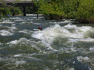 The deep canyon of the river northeast of Bakersfield is a popular location for fly fishing
and particularly famous for whitewater sports including whitewater rafting, whitewater kayaking
, and riverboarding
.
The Kern is also well known for its danger, and is sometimes known as the "Killer Kern". A sign at the mouth of Kern Canyon warns visitors, "Danger. Stay Out. Stay Alive" and tallies the deaths since 1968; as of July 12, 2010 the count was up to 251. Merle Haggard
's song Kern River fictionally recounts such a tragedy. Most of the people who die in the Kern river are campers and amateur recreational users who enter the water without proper life vests. Less than 2% of the deaths on the Kern have occurred on commercial raft trips.
The Kern is nevertheless a popular place for camping, hiking, fishing and recreational vacation. There are developed campgrounds maintained by the US Forest Service along the North Fork of the Kern River. Campgrounds include Camp 3, Fairview, Goldledge, Headquarters, Hospital Flat, and Limestone. All of the campgrounds are open in summer months while only a few remain open year round. There are also plenty of undeveloped areas available for free camping off the Mountain Highway 99. Of particular interest to fisherman are the Little Kern Trout and the Golden Trout.
Below the canyon the Kern River has a gradient of 0.3% until it reaches the Kern River Oil Field and begins to meander along flat land into and through the city of Bakersfield. It is a popular summer pastime to float down the river on inner tubes in the Class II sections near Bakersfield far outside of the Kern Canyon. This activity is often done in groups and beer is taken along in an ice chest rigged to float alongside, though dangerous.
U.S. state
A U.S. state is any one of the 50 federated states of the United States of America that share sovereignty with the federal government. Because of this shared sovereignty, an American is a citizen both of the federal entity and of his or her state of domicile. Four states use the official title of...
of California
California
California is a state located on the West Coast of the United States. It is by far the most populous U.S. state, and the third-largest by land area...
, approximately 165 miles (265.5 km) long. It drains an area of the southern Sierra Nevada mountains northeast of Bakersfield
Bakersfield, California
Bakersfield is a city near the southern end of the San Joaquin Valley in Kern County, California. It is roughly equidistant between Fresno and Los Angeles, to the north and south respectively....
. Fed by snowmelt near Mount Whitney
Mount Whitney
Mount Whitney is the highest summit in the contiguous United States with an elevation of . It is on the boundary between California's Inyo and Tulare counties, west-northwest of the lowest point in North America at Badwater in Death Valley National Park...
, the river passes through scenic canyons in the mountains and is a popular destination for whitewater rafting and kayaking
Kayaking
Kayaking is the use of a kayak for moving across water. Kayaking and canoeing are also known as paddling. Kayaking is distinguished from canoeing by the sitting position of the paddler and the number of blades on the paddle...
. It is the only major river in the Sierra Nevada mountain range that drains in a southerly direction.
The Kern River formerly emptied into now dry Kern Lake via the Kern River Slough
Kern River Slough
Kern River Slough, the distrubutary of the Kern River runing south from the vicinity of Bakersfield to Kern Lake near Arvin. Now dry from agricultural diversion of its waters....
and Kern Lake in turn emptied into Buena Vista Lake via the Buena Vista Slough at the southern end of the Central Valley
California Central Valley
California's Central Valley is a large, flat valley that dominates the central portion of California. It is home to California's most productive agricultural efforts. The valley stretches approximately from northwest to southeast inland and parallel to the Pacific Ocean coast. Its northern half is...
. Buena Vista Lake in turn when overflowing, drained into Tulare Lake
Tulare Lake
Tulare Lake, named Laguna de Tache by the Spanish, is a fresh-water dry lake with residual wetlands and marshes in southern San Joaquin Valley, California...
via a series of slough
Slough (hydrology)
For other uses, see Slough .Slough , is a term in hydrology that refers to:* Slough, a stream distributary or anabranch, or in some cases, a regular stream.More localized meanings of Slough are:...
s. They were part of a partially endorheic basin that sometimes overflowed into the San Joaquin River
San Joaquin River
The San Joaquin River is the largest river of Central California in the United States. At over long, the river starts in the high Sierra Nevada, and flows through a rich agricultural region known as the San Joaquin Valley before reaching Suisun Bay, San Francisco Bay, and the Pacific Ocean...
. This basin also included the Kaweah
Kaweah River
The Kaweah River in the U.S. state of California flows westward from the foothills of the Sierra Nevada into the Central Valley. It rises in forks in the southern Sierra Nevada inside Sequoia National Park, the longest of which is the Middle Fork, about long...
and Tule River
Tule River
The Tule River, also called Rio de San Pedro or Rio San Pedro, is a river in Tulare County in the U.S. state of California. The river originates in the Sierra Nevada east of Porterville and consists of three forks, North, Middle and South. The North Fork and Middle Fork meet above Springville. The...
s as well as southern distributaries
Distributary
A distributary, or a distributary channel, is a stream that branches off and flows away from a main stream channel. They are a common feature of river deltas. The phenomenon is known as river bifurcation. The opposite of a distributary is a tributary...
of the Kings
Kings River (California)
The Kings River is a major river of south-central California. About long, it drains an area of the high western Sierra Nevada and the Central Valley. A large alluvial fan has formed where the river's gradient decreases in the Central Valley so the river divides into distributaries...
.
Since the late 19th century the Kern has been almost entirely diverted for irrigation, recharging aquifers and the California Aqueduct
California Aqueduct
The Governor Edmund G. Brown California Aqueduct is a system of canals, tunnels, and pipelines that conveys water collected from the Sierra Nevada Mountains and valleys of Northern- and Central California to Southern California. The Department of Water Resources operates and maintains the...
, although some water empties into Lake Webb and Lake Evans, two small lakes in a portion of the former Buena Vista Lakebed. The lakes were created in 1973 for recreational use. The lakes hold 6800 acre.ft combined. Crops are grown in the rest of the former lakebed. In extremely wet years the river will reach the Tulare Lake
Tulare Lake
Tulare Lake, named Laguna de Tache by the Spanish, is a fresh-water dry lake with residual wetlands and marshes in southern San Joaquin Valley, California...
basin through a series of sloughs and flood channels.
Course
The Kern River is the southernmost river in the San Joaquin ValleySan Joaquin Valley
The San Joaquin Valley is the area of the Central Valley of California that lies south of the Sacramento – San Joaquin River Delta in Stockton...
. It begins in the Sierra Nevada on the eastern side of Tulare County and ends on the west side of Kern County where it is mainly diverted for local water supplies. The main branch of the river (sometimes called the North Fork Kern River) rises from several small lakes west of Mount Whitney
Mount Whitney
Mount Whitney is the highest summit in the contiguous United States with an elevation of . It is on the boundary between California's Inyo and Tulare counties, west-northwest of the lowest point in North America at Badwater in Death Valley National Park...
in the high Sierra Nevada mountains in northeastern Tulare County
Tulare County, California
Tulare County is a county located in the Central Valley of the U.S. state of California, south of Fresno. Sequoia National Park is located in the county, as are part of Kings Canyon National Park, in its northeast corner , and part of Mount Whitney, on its eastern border...
, in the northeast corner of Sequoia National Park
Sequoia National Park
Sequoia National Park is a national park in the southern Sierra Nevada east of Visalia, California, in the United States. It was established on September 25, 1890. The park spans . Encompassing a vertical relief of nearly , the park contains among its natural resources the highest point in the...
. It flows south through the mountains, passing through Inyo
Inyo National Forest
Inyo National Forest is a federally administered forest in the United States. The forest covers parts of the eastern Sierra Nevada of California, and the White Mountains of California and Nevada. It contains two wilderness areas: the John Muir Wilderness and the Ansel Adams Wilderness...
and Sequoia
Sequoia National Forest
Sequoia National Forest is located in the southern Sierra Nevada mountains of California. The U.S. National Forest is named for the majestic Giant Sequoia trees which populate 38 distinct groves within the boundaries of the forest....
national forests, and the Golden Trout Wilderness
Golden Trout Wilderness
The Golden Trout Wilderness is a federally designated wilderness area in the Sierra Nevada, in Tulare County, California. It is located east of Visalia, California within Inyo National Forest and Sequoia National Forest....
. The Little Kern River joins from the northwest at a site called Forks of the Kern.
At Kernville
Kernville, California
Kernville is a census-designated place in the southern Sierra Nevadas, in Kern County, California, United States. Kernville is located northeast of Bakersfield, at an elevation of 2667 feet...
the river emerges from its narrow canyon into a widening valley where it is impounded in Lake Isabella
Lake Isabella
Lake Isabella is a reservoir in Kern County, California created by the earthen Isabella Dam. It was formed in 1953 when the U.S. Army Corps of Engineers dammed the Kern River at the junction of its two forks at Whiskey Flat. At 11,000 acres , it is one of the larger reservoirs in California...
, a reservoir formed by Isabella Dam. The area was once known as Whiskey Flat, the former location of the town of Kernville. The South Fork Kern River
South Fork Kern River
The South Fork Kern River is a tributary of the Kern River in the Sierra Nevada of the U.S. state of California. It is one of the southernmost rivers on the western slope of the mountains, and drains an area of that comprises mostly rugged mountain ridges and dry evergreen forest...
joins in Lake Isabella. Like the North Fork, the South Fork rises in Tulare County and flows mainly south, through Inyo National Forest. After entering Kern County the South Fork curves to the west and flows into Lake Isabella.
Below Isabella Dam the Kern River flows southwest through a spectacular rugged canyon along the south edge of the Greenhorn Mountains
Greenhorn Mountains
The Greenhorn Mountains are located northeast of Bakersfield, California and west of Lake Isabella in the United States. The range, at the southern end of the Sierra Nevada, reaches an elevation of at Sunday Peak, just south of Portuguese Pass....
, emerging from mountains east of Bakersfield
Bakersfield, California
Bakersfield is a city near the southern end of the San Joaquin Valley in Kern County, California. It is roughly equidistant between Fresno and Los Angeles, to the north and south respectively....
, the largest city on the river. In the Kern's lower course downstream from Bakersfield the river is highly diverted through a series of canals to irrigate the farms of the southern San Joaquin Valley
San Joaquin Valley
The San Joaquin Valley is the area of the Central Valley of California that lies south of the Sacramento – San Joaquin River Delta in Stockton...
and provide municipal water supplies to the City of Bakersfield and surrounding areas. In this region near Bakersfield the Kern River once spread out into vast wetlands and seasonal lakes.
The Friant-Kern Canal
Friant-Kern Canal
The Friant-Kern Canal is a Central Valley Project aqueduct managed by the United States Bureau of Reclamation in Central California to convey water to augment irrigation capacity in Fresno, Tulare, and Kern counties....
, constructed as part of the Central Valley Project, joins the river about four miles (6 km) west of downtown Bakersfield.
The Kern River is one of the very few rivers in the Central Valley which does not contribute water to the Central Valley Project
Central Valley Project
The Central Valley Project is a Bureau of Reclamation federal water project in the U.S. state of California. It was devised in 1933 in order to provide irrigation and municipal water to much of California's Central Valley—by regulating and storing water in reservoirs in the water-rich northern...
(CVP). However, water from the CVP, mainly the Friant-Kern Canal, will be deposited for water storage in the aquifers.
Historically, the river flowed an additional 20 miles (32.2 km) south through a now-dry distributary
Distributary
A distributary, or a distributary channel, is a stream that branches off and flows away from a main stream channel. They are a common feature of river deltas. The phenomenon is known as river bifurcation. The opposite of a distributary is a tributary...
to Arvin
Arvin, California
Arvin is a city in Kern County, in the United States. Arvin is located southeast of Bakersfield, at an elevation of 449 feet . As of the 2010 census, the population was 19,304, up from 12,956 at the 2000 census....
, where it formed the seasonal Kern Lake, which would grow to cover about 8300 acres (33.6 km²) during wet periods. Water from Kern Lake would then flow west through Buena Vista Slough into Lake Buena Vista, another seasonal lake that reached sizes of about 4000 acres (16.2 km²). Another channel of the Kern River flowed from the Bakersfield area southwest directly to Buena Vista Lake. In periods of high runoff, Buena Vista Lake overflowed and joined other wetlands and seasonal lakes in a series of sloughs that drained north into the former Tulare Lake
Tulare Lake
Tulare Lake, named Laguna de Tache by the Spanish, is a fresh-water dry lake with residual wetlands and marshes in southern San Joaquin Valley, California...
, which would sometimes overflow into the San Joaquin River
San Joaquin River
The San Joaquin River is the largest river of Central California in the United States. At over long, the river starts in the high Sierra Nevada, and flows through a rich agricultural region known as the San Joaquin Valley before reaching Suisun Bay, San Francisco Bay, and the Pacific Ocean...
via Berenda Slough, forming one of the longest river systems in California at 535 miles (861 km).
History
John C. Frémont
John Charles Frémont , was an American military officer, explorer, and the first candidate of the anti-slavery Republican Party for the office of President of the United States. During the 1840s, that era's penny press accorded Frémont the sobriquet The Pathfinder...
in honor of Edward M. Kern
Edward Kern
Edward Meyer Kern was born 26 Oct 1822 or 1823 in Philadelphia - the son of John Kern III and Mary Elizabeth Bignell. He was trained as an artist and was appointed to accompany John C. Fremont on his third expedition in 1845. He was paid $3.00 a day on this trip. He served as cartographer as well...
in 1845 who, as the story goes, nearly drowned in the turbulent waters. Kern was the topographer
Topography
Topography is the study of Earth's surface shape and features or those ofplanets, moons, and asteroids...
of Fremont's third expedition through the American West. Before this, the Kern River was known as the "Rio de San Felipe" as named by Spanish missionary explorer Fr. Francisco Garcés
Francisco Garcés
Francisco Hermenegildo Tomás Garcés was a Spanish Franciscan missionary who explored much of the southwestern part of North America, including what are now Arizona, southern California, and northeastern Baja California. Garcés was born April 12, 1738, in Morata de Jalón , Zaragoza province,...
when he explored the Bakersfield area on May 1, 1776. On August 2, 1806, Padre Zavidea renamed the river La Porciuncula for the day of the Porciuncula Indulgence. It was locally known as Po-sun-co-la until its renaming by Fremont.
Gold
Gold
Gold is a chemical element with the symbol Au and an atomic number of 79. Gold is a dense, soft, shiny, malleable and ductile metal. Pure gold has a bright yellow color and luster traditionally considered attractive, which it maintains without oxidizing in air or water. Chemically, gold is a...
was discovered along the upper river in 1853. The snowmelt that fed the river resulted in periodic torrential flooding in Bakersfield until the construction of the Isabella Dam in the 1950s. These floods would periodically change the channel of the river. Since the establishment of Kern County in 1866 the main channel has flowed through what is the main part of downtown Bakersfield along Truxtun Avenue and again made a south turn along what is Old River Road. Many of the irrigation canals that flow in a southerly direction from the river follow the old channels of the Kern River, especially the canal that flows along Old River Road. The irrigated region of the Central Valley near the river supports the cultivation of alfalfa
Alfalfa
Alfalfa is a flowering plant in the pea family Fabaceae cultivated as an important forage crop in the US, Canada, Argentina, France, Australia, the Middle East, South Africa, and many other countries. It is known as lucerne in the UK, France, Australia, South Africa and New Zealand, and known as...
, carrots, fruit, and cotton
Cotton
Cotton is a soft, fluffy staple fiber that grows in a boll, or protective capsule, around the seeds of cotton plants of the genus Gossypium. The fiber is almost pure cellulose. The botanical purpose of cotton fiber is to aid in seed dispersal....
, cattle grazing, and many other year-round crops. In 1987 the United States Congress
United States Congress
The United States Congress is the bicameral legislature of the federal government of the United States, consisting of the Senate and the House of Representatives. The Congress meets in the United States Capitol in Washington, D.C....
designated 151 mi (240 km) of the Kern's North (Main) Fork and South Fork as a National Wild and Scenic River
National Wild and Scenic River
National Wild and Scenic River is a designation for certain protected areas in the United States.The National Wild and Scenic Rivers Act was an outgrowth of the recommendations of a Presidential commission, the Outdoor Recreation Resources Review Commission...
.
The Great 1857 Fort Tejon earthquake
Fort Tejon earthquake
The Fort Tejon earthquake occurred at about 8:20 AM on January 9, 1857. It ruptured the San Andreas Fault for a length of about 225 miles , between Parkfield and Wrightwood. The average slip along the fault was 4.5 meters , and a maximum offset of 9 meters was recorded in the Carrizo Plain area...
on January 9, 1857 with an estimated magnitude of 7.9 on the San Andreas Fault
San Andreas Fault
The San Andreas Fault is a continental strike-slip fault that runs a length of roughly through California in the United States. The fault's motion is right-lateral strike-slip...
was strong enough to temporarily switch the direction of the flow of the Kern River. Fish in the now dry Tulare Lake
Tulare Lake
Tulare Lake, named Laguna de Tache by the Spanish, is a fresh-water dry lake with residual wetlands and marshes in southern San Joaquin Valley, California...
were left stranded on the shores.
In recent years the river has become controversial because of attempts by the City of Bakersfield to retain water in the river channel all year round for recreation and the recharging of the water tables from which it draws its drinking water supply. The attempts have resulted in conflicts with established agricultural interests in the Central Valley which depend heavily on the river as a supply of irrigation water. However, the river recently has been allowed to flow its normal dry course due to structural problems in the Isabella Dam. The increased flow reduces stress on the dam.
Ecology
The Kern River watershed is famous for hosting California's State Freshwater Fish, California Golden TroutGolden Trout
The golden trout is a sub-species of the rainbow trout, and it closley resembles the juvenile Rainbow trout. The fish is also known as the California golden trout and is native to Golden Trout Creek, Volcano Creek and the South Fork Kern River. Another variant, O. m...
(Oncorhynchus mykiss ssp.), which are native to the Kern River tributaries South Fork Kern River
South Fork Kern River
The South Fork Kern River is a tributary of the Kern River in the Sierra Nevada of the U.S. state of California. It is one of the southernmost rivers on the western slope of the mountains, and drains an area of that comprises mostly rugged mountain ridges and dry evergreen forest...
and Golden Trout Creek, and the latter's tributary, Volcano Creek.
After public outcry, the City of Bakersfield and the California Department of Fish and Game
California Department of Fish and Game
The California Department of Fish and Game is a department within the government of California, falling under its parent California Natural Resources Agency. The Department of Fish and Game manages and protects the state's diverse fish, wildlife, plant resources, and native habitats...
(CDFG) decided to relocate a family of California Golden beaver (Castor canadensis subauratus) instead of killing them. California Golden beaver were native to the Central Valley and throughout the Sierra Nevada
Beaver in the Sierra Nevada
The North American beaver had a historic range that overlapped the Sierra Nevada in California. Before the European colonization of the Americas, beaver were distributed from the arctic tundra to the deserts of northern Mexico...
. Specifically to the Kern watershed, an oral history was taken from Roy De Voe, who claimed to have seen "very old beaver sign" on the east side of the Kern River at Funston Meadow (elevation 6,476 feet) in 1946. Also, Mr. De Voe reported that his friend Kenny Keelor trapped the Kern River for beaver around 1900, making his camp at the mouth of Rattlesnake Creek (elevation 6,585) until they were trapped out completely by 1910 - 1914. The presence of Beaver Canyon Creek, tributary to the lower Kern River just east of Delonegha Hot Springs, is also consistent with the Kern River watershed having historically supported native beaver. This oral history is consistent with another oral history taken one watershed to the north by CDFG's Donald T. Tappe from a retired game warden in 1940, who stated that beaver were "apparently not uncommon on the upper part of the Kings River
Kings River
-In the United States:*Kings River, former name of Centerville, Fresno County, California*Kings River in Arkansas and Missouri, United States*Kings River in California, United States*Kings River in Nevada, United States...
" until 1882-1883. Currently, there are large numbers of beaver in the Ramshaw Meadows on the South Fork Kern River where their dams are trapping sediment, forming extensive pools, accelerating meadow restoration, and increasing riparian willow habitat.
Geology
The Kern River Canyon was created primarily as a result of tectonic forces, and not just by the erosional force of the river. The geologically active Kern Canyon FaultKern Canyon Fault
The Kern Canyon Fault is a geological fault which runs the length of Kern Canyon in the southern Sierra Nevada mountains in California.The fault was once considered inactive, but recent studies show the contrary...
runs the length of the canyon.
The Kern River Oil Field
Kern River Oil Field
The Kern River Oil Field is a large oil field in Kern County in the San Joaquin Valley of California, north-northeast of Bakersfield in the lower Sierra foothills...
is adjacent to the river on the north, just before the river flows into Bakersfield. The large oil field, on low hills which rise gradually into the Sierra foothills, formerly allowed much of its produced water to drain directly south into the river. However, modern environmental regulation ended this practice, and the contaminated water is now cleaned at water treatment plants and used to irrigate farms in the valley to the west.
Discharge
Due to water diversion and Isabella DamIsabella Dam
Isabella Dam is an embankment dam located about halfway down the Kern River, between the towns of Kernville and Lake Isabella in Kern County, California. Isabella Dam serves agricultural, hydroelectric, and flood control uses.-History:...
the Kern River's discharge
Discharge (hydrology)
In hydrology, discharge is the volume rate of water flow, including any suspended solids , dissolved chemical species and/or biologic material , which is transported through a given cross-sectional area...
changes considerably over its length. The highest mean annual flows occur just downriver of Isabella Dam, but because the dam serves to regulate the flow of water the highest daily discharges occur above the dam on the North Fork section of the Kern River. The USGS stream gage on the North Fork Kern River has recorded an average annual mean discharge of 806 cuft/s and a maximum daily discharge of 33600 cuft/s, and the gage on the South Fork Kern River shows an average annual mean of 123 cuft/s and a maximum daily discharge of 14000 cuft/s. In contrast the first stream gage below Isabella Dam has recorded an average annual mean of 946 cuft/s but a maximum daily discharge of only 7030 cuft/s. Due to water withdrawals the three stream gage stations below Isabella Dam show a dramatically decreasing discharge. At the last gage, near Bakersfield, the river's average flow is only 312 cuft/s.
Recreation
Fly fishing
Fly fishing is an angling method in which an artificial 'fly' is used to catch fish. The fly is cast using a fly rod, reel, and specialized weighted line. Casting a nearly weightless fly or 'lure' requires casting techniques significantly different from other forms of casting...
and particularly famous for whitewater sports including whitewater rafting, whitewater kayaking
Whitewater kayaking
Whitewater kayaking is the sport of paddling a kayak on a moving body of water, typically a whitewater river. Whitewater kayaking can range from simple, carefree gently moving water, to demanding, dangerous whitewater. River rapids are graded like ski runs according to the difficulty, danger or...
, and riverboarding
Riverboarding
Riverboarding is a boardsport in which the participant lies prone on their board with fins on their feet for propulsion and steering. This sport is also known as hydrospeed in Europe and as riverboarding or white-water sledging in New Zealand, depending on the type of board used...
.
The Kern is also well known for its danger, and is sometimes known as the "Killer Kern". A sign at the mouth of Kern Canyon warns visitors, "Danger. Stay Out. Stay Alive" and tallies the deaths since 1968; as of July 12, 2010 the count was up to 251. Merle Haggard
Merle Haggard
Merle Ronald Haggard is an American country music singer, guitarist, fiddler, instrumentalist, and songwriter. Along with Buck Owens, Haggard and his band The Strangers helped create the Bakersfield sound, which is characterized by the unique twang of Fender Telecaster guitars, vocal harmonies,...
's song Kern River fictionally recounts such a tragedy. Most of the people who die in the Kern river are campers and amateur recreational users who enter the water without proper life vests. Less than 2% of the deaths on the Kern have occurred on commercial raft trips.
The Kern is nevertheless a popular place for camping, hiking, fishing and recreational vacation. There are developed campgrounds maintained by the US Forest Service along the North Fork of the Kern River. Campgrounds include Camp 3, Fairview, Goldledge, Headquarters, Hospital Flat, and Limestone. All of the campgrounds are open in summer months while only a few remain open year round. There are also plenty of undeveloped areas available for free camping off the Mountain Highway 99. Of particular interest to fisherman are the Little Kern Trout and the Golden Trout.
Below the canyon the Kern River has a gradient of 0.3% until it reaches the Kern River Oil Field and begins to meander along flat land into and through the city of Bakersfield. It is a popular summer pastime to float down the river on inner tubes in the Class II sections near Bakersfield far outside of the Kern Canyon. This activity is often done in groups and beer is taken along in an ice chest rigged to float alongside, though dangerous.