

Zambezi
Encyclopedia
The Zambezi is the fourth-longest river
in Africa
, and the largest flowing into the Indian Ocean
from Africa. The area of its basin
is 1390000 square kilometres (536,682 sq mi), slightly less than half that of the Nile
. The 3540 kilometres (2,199.7 mi) has its source in Zambia
and flows through Angola
, along the borders of Namibia
, Botswana
, Zambia again, and Zimbabwe
, to Mozambique
, where it empties into the Indian Ocean
.
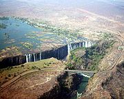
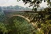
The Zambezi's most spectacular feature is the beautiful Victoria Falls
. Other notable falls include the Chavuma Falls
at the border between Zambia and Angola, and Ngonye Falls
, near Sioma in Western Zambia.
There are two main sources of hydroelectric power on the river. These are the Kariba Dam
, which provides power to Zambia and Zimbabwe and the Cahora Bassa Dam
in Mozambique which provides power to both Mozambique and South Africa. There is also a smaller power station at Victoria Falls.
in north-western Zambia, in undulating miombo woodland, quite dense in parts, about 1,524 m (4,900 ft) above sea level
. Eastward of the source, the watershed
between the Congo
and Zambezi basins is a well-marked belt of high ground, falling abruptly north and south, and running nearly east-west. This distinctly cuts off the basin of the Lualaba (the main branch of the upper Congo) from that of the Zambezi. In the neighborhood of the source the watershed is not as clearly defined, but the two river systems do not connect.
The region drained by the Zambezi is a vast broken-edged plateau 900–1200 m high, composed in the remote interior of metamorphic
beds and fringed with the igneous rocks of the Victoria Falls. At Shupanga, on the lower Zambezi, thin strata of grey and yellow sandstone
s, with an occasional band of limestone
, crop out on the bed of the river in the dry season, and these persist beyond Tete
, where they are associated with extensive seams of coal
. Coal is also found in the district just below the Victoria Falls. Gold
-bearing rocks occur in several places.
such as the Luena
and the Chifumage flowing from highlands to the north-west. It turns south and develops a floodplain and becomes very variable in width between the dry and rainy seasons. It enters a region with dense patches of evergreen Cryptosepalum dry forest, though on its western side, Western Zambezian grasslands also occur. Where it re-enters Zambia it is nearly 400 metres (1,312.3 ft) wide in the rainy season and flows quite quickly with rapids ending in the Chavuma Falls
, where the river flows through a rocky fissure. The river drops about 400 metres (1,312.3 ft) in elevation from its source at 1500 metres (4,921.3 ft) to the Chavuma Falls at 1100 metres (3,608.9 ft), in a distance of about 400 kilometres (248.5 mi). From this point to the Victoria Falls, the level of the basin is very uniform, dropping only by another 180 metres (590.6 ft) in a distance of around 800 kilometres (497.1 mi).
The first of its large tributaries to enter the Zambezi is the Kabompo River
in the north-western province of Zambia. The savanna
through which the river has flowed gives way to a wide floodplain, studded with Borassus
fan palm
s. A little farther south is the confluence
with the Lungwebungu River
. This is the beginning of the Barotse Floodplain
, the most notable feature of the upper Zambezi, but this northern part does not flood so much and includes islands of higher land in the middle
Thirty kilometres (20 mi) below the confluence of the Lungwebungu the country becomes very flat, and the typical Barotse Floodplain landscape unfolds, with the flood reaching a width of 25 kilometres (15.5 mi) in the rainy season. For more than 200 kilometres (124.3 mi) downstream the annual flood cycle dominates the natural environment and human life, society and culture.
Eighty kilometres (50 mi) further down, the Luanginga, which with its tributaries drains a large area to the west, joins the Zambezi. A few kilometres higher up on the east the main stream is joined in the rainy season by overflow of the Luampa/Luena
system.
A short distance downstream of the confluence with the Luanginga is Lealui
, one of the capitals of the Lozi people
who populate the Zambian region of Barotseland
in Western Province. The chief of the Lozi maintains one of his two compounds at Lealui; the other is at Limulunga
, which is on high ground and serves as the capital during the rainy season. The annual move from Lealui to Limulunga is a major event, celebrated as one of Zambia's best known festivals, the Kuomboka
.
After Lealui, the river turns to south-south-east. From the east it continues to receive numerous small streams, but on the west is without major tributaries for 240 km (150 mi). Before this, the Ngonye Falls
and subsequent rapids interrupt navigation. South of Ngonye Falls, the river briefly borders Namibia's Caprivi Strip
. The strip projects from the main body of Namibia, and results from the colonial era: it was added to German South-West Africa
expressly to give Germany access to the Zambezi.
Below the junction of the Cuando River
and the Zambezi the river bends almost due east. Here, the river is very broad and shallow, and flows fairly slowly, but as it flows eastward towards the border of the great central plateau of Africa it reaches a chasm into which the Victoria Falls plunge.
 The Victoria Falls are considered the boundary between the upper and middle Zambezi. Below them the river continues to flow due east for about 200 kilometres (124.3 mi), cutting through perpendicular walls of basalt
20 to 60 metres (66 to 200 ft) apart in hills 200 to 250 metres (660 to 820& ft) high. The river flows swiftly through the Batoka Gorge, the current being continually interrupted by reefs. It has been described as one of the world's most spectacular whitewater trips, a tremendous challenge for kayakers and rafters alike. Beyond the gorge are a succession of rapids which end 240 km (150 mi) below Victoria Falls. Over this distance, the river drops 250 metres (820.2 ft).
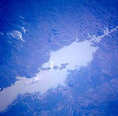
At this point, the river enters Lake Kariba
, created in 1959 following the completion of the Kariba Dam
. The lake is one of the largest man-made lakes in the world, and the hydroelectric power-generating facilities at the dam provide electricity to much of Zambia and Zimbabwe
.
The Luangwa
and the Kafue
are the two largest left-hand tributaries of the Zambezi. The Kafue joins the main river in a quiet deep stream about 180 metres (590.6 ft) wide. From this point the northward bend of the Zambezi is checked and the stream continues due east. At the confluence of the Luangwa (15°37' S) it enters Mozambique.
The middle Zambezi ends where the river enters Lake Cahora Bassa
(also spelled Cabora Bassa). Formerly the site of dangerous rapids known as Kebrabassa, the lake was created in 1974 by the construction of the Cahora Bassa Dam.
. This shallowness arises as the river enters a broad valley and spreads out over a large area. Only at one point, the Lupata Gorge
, 320 km (200 mi) from its mouth, is the river confined between high hills. Here it is scarcely 200 m wide. Elsewhere it is from 5 to 8 km (3 to 5 mi) wide, flowing gently in many streams. The river bed is sandy, and the banks are low and reed-fringed. At places, however, and especially in the rainy season, the streams unite into one broad fast-flowing river.
About 160 km (100 mi) from the sea the Zambezi receives the drainage of Lake Malawi
through the Shire River
. On approaching the Indian Ocean
, the river splits up into a delta. Each of the four prinmbe (distributaries?), Kongone, Luabo and Timbwe, is obstructed by a sand bar. A more northerly branch, called the Chinde mouth, has a minimum depth at low water of 2 m at the entrance and 4 m further in, and is the branch used for navigation. 100 km (60 mi) further north is a river called the Quelimane
, after the town at its mouth. This stream, which is silting up, receives the overflow of the Zambezi in the rainy season.
The delta of the Zambezi is today about half as broad as it was before the construction of the Kariba
and Cahora Bassa
dams controlled the seasonal variations in the flow rate of the river.
Before the dams were built seasonal flooding of the Zambezi had quite a different impact on the ecosystems of the delta from today as it brought nutritious fresh water down to the Indian Ocean coastal wetlands. The lower Zambezi experienced a small flood
surge early in the dry season as rain in the Gwembe catchment and north-eastern Zimbabwe rushed through while rain in the Upper Zambezi, Kafue, and Lake Malawi basins, and Luangwa to a lesser extent, is held back by swamps and floodplains. The discharge of these systems contributed to a much larger flood in March or April, with a mean monthly maximum for April of 6700 cubic metres (236,608.3 cu ft) per second at the delta. The record flood was more than three times as big, 22500 cubic metres (794,580 cu ft) per second being recorded in 1958. By contrast the discharge at the end of the dry season averaged just 500 cubic metres (17,657.3 cu ft) per second.
In the 1960s and 1970s the building of dams changed that pattern completely. Downstream the mean monthly minimum–maximum was 500 cubic metres (17,657.3 cu ft) to 6000 cubic metres (211,888 cu ft) per second; now it is 1000 cubic metres (35,314.7 cu ft) to 3900 cubic metres (137,727.2 cu ft) per second. Medium-level floods especially, of the kind to which the ecology of the lower Zambezi was adapted, happen less often and have a shorter duration. As with the Itezhi-Tezhi Dam
's deleterious effects on the Kafue Flats, this has the following effects:
, Pungwe
, and Save
rivers which also drain the Zambezi basin. Together the floodplains of these four river floodplains make up the World Wildlife Fund's Zambezian coastal flooded savanna ecoregion
. They are a mixture of open grassland and freshwater swamp inland from the Indian Ocean in Mozambique.
Although the dams have stemmed some of the annual flood
ing of the lower Zambezi and caused the area of floodplain to be greatly reduced they have not removed flooding completely. They cannot control extreme floods, they have only made medium-level floods less frequent. When heavy rain in the lower Zambezi combines with good runoff upstream, massive floods still happen and the wetlands are still an important habitat. However, as well as the shrinking of the wetlands further severe damage to wildlife was caused by uncontrolled hunting of animals such as buffalo
and waterbuck
during the Mozambique Civil War and now the conflict has ceased it is likely the floodplains will become more populated, and further damming has also been discussed. The only protected area of floodplain is the Marromeu Game Reserve near the city of Beira
.
Although the region has seen a reduction in the populations of the large mammals it is still home to some including the Reedbuck
and migrating eland
. Carnivores found here include lion
(Panthera leo), leopard
(Panthera pardus), cheetah
(Acinonyx jubatus), spotted hyena
(Crocuta crocuta) and Side-striped jackal
(Canis adustus). The floodplains are a haven for migratory waterbirds including Pintail
s, Garganey
, African Openbill (Anastomus lamelligerus), Saddle-billed Stork
(Ephippiorhynchus senegalensis), Wattled Crane
, and Great White Pelican (Pelecanus onocrotalus).
Reptiles include Nile crocodile
(Crocodylus niloticus), Nile monitor
lizard (Varanus niloticus) and African rock python
(Python sebae), the endemic Pungwe worm snake (Leptotyphlops pungwensis) and three other snakes that are nearly endemic; Floodplain Water Snake (Lycodonomorphus whytei obscuriventris), Dwarf wolf snake (Lycophidion nanus) and Eyebrow viper (Proatheris
).
There are a number of endemic butterflies.
rates are high (1600 mm-2300 mm) and much water is lost this way in swamps and floodplains, especially in the south-west of the basin.
es are abundant along most of the calm stretches of the river, and many crocodile
s are also present. Monitor lizard
s are found in many places. Birds are abundant, with species including heron
, pelican
, egret
and African fish eagle
present in large numbers. Riverine woodland also supports many large animals, such as buffalo
, zebra
s, giraffe
s, elephant
s.
The Zambezi also supports several hundred species of fish
, some of which are endemic
to the river. Important species include cichlid
s which are fished heavily for food, as well as catfish
, tigerfish
, yellowfish
and other large species. The bull shark
is sometimes known as the Zambezi Shark after the river but is found around the world. It normally inhabits coast
al waters but has been found far inland in many large rivers including the Zambezi.
Middle Zambezi cumulatively 1,050,000 km², 2442 m³/s, measured at Cahora Bassa Gorge
Lower Zambezi cumulatively, 1,378,000 km², 3424 m³/s, measured at Marromeu
Total Zambezi river basin: 1,390,000 km², 3424 m³/s discharged into delta
Source: Beilfuss & Dos Santos (2001) The Okavango Basin
is not included in the figures because it only occasionally overflows to any extent into the Zambezi.
Due to the rainfall distribution, northern tributaries contribute much more water than southern ones, for example: the Northern Highlands catchment of the upper Zambezi contributes 25%, Kafue 8%, Luangwa and Shire Rivers 16% each, total 65% of Zambezi discharge. The large Cuando basin in the south-west on the other hand contributes only about 2 m³/s because most is lost through evaporation in its swamp systems. The 1940s and 1950s were particularly wet decades in the basin. Since 1975, it has been drier, the average discharge being only 70% of that for the years 1930 to 1958.
to the Limpopo River
. The land around the pan experienced tectonic uplift
(perhaps as part of the African superswell
) and a large lake formed, and extended east.
Meanwhile, 1000 kilometres (621.4 mi) east, a western tributary of the Shire River
in the Great Rift Valley
's southern extension through Malawi
eroded a deep valley on its western escarpment. At the rate of a few cm
per year, this river, the Middle Zambezi, started cutting back the bed of its river towards the west, aided by graben
s (rift valley
s) forming along its course in an east-west axis. As it did so it captured
a number of south-flowing rivers such as the Luangwa and Kafue.
Eventually the large lake trapped at Makgadikgadi (or a tributary of it) was captured by the Middle Zambezi cutting back towards it, and emptied eastwards. The Upper Zambezi was captured as well. The Middle Zambezi was about 300 metres (984.3 ft) lower than the Upper Zambezi, and a high waterfall formed at the edge of the basalt plateau across which the upper river flows. This was the first Victoria Falls, somewhere down the Batoka Gorge near where Lake Kariba is now. For details of how the falls cuts back its bed to form the gorge, see How the Victoria Falls formed.
, in January 1498, who anchored at what he called Rio dos Bons Sinais (River of Good Omens), now the Quelimane
, a small river on the northern end of the delta, which at that time was connected by navigable channels to the Zambezi river proper (the connection silted up by the 1830s). In a few of the oldest maps, the entire river is denoted as such. But already by the early 1500s, a new named emerged, the Cuama river (sometimes 'Quama' or 'Zuama'). Cuama was the local name given by the dwellers of the Swahili Coast
for an outpost located on one the southerly islands of the delta, near the Luabo river Most old nautical maps denote the Luabo entry as Cuama, the entire delta as the 'rivers of Cuama' and the Zambezi river proper as the 'Cuama river'.
Nonetheless, already in 1552, Portuguese chronicler João de Barros
notes that the same Cuama river was called Zembere by the upriver people of Monomatapa. The Portuguese Dominican friar João dos Santos
, visiting Monomatapa in 1597, reported it as Zambeze (Bantu language frequently shifts between z and r) and inquired into the origins of the name, and was told it was named after an upriver people or settlement.
Thus 'Zambezi' is a derivation from a locality, probably named 'M'biza' (or something very close to that) in the original Bantu.
The Monomatapa notion that the Zambezi was sourced from a great internal lake might be a reference to one of the African Great Lakes
. Indeed, one of the names reported by early explorers for Lake Malawi
was 'Lake Zambre' (probably a corruption of 'Zambezi'). The Monomatapa story complied with the European notion - drawn from classical antiquity - that all the great African rivers - the Nile, the Senegal, the Congo, now the Zambezi too - were all sourced from the same great internal lake. The Portuguese were also told that the Mozambican Espirito Santo 'river'(actually an estuary formed by the Umbeluzi, Matola
and Tembe rivers) was sourced from a lake (hence its outlet became known as Delagoa Bay). As a result, many old maps show the Zambezi and the 'Espirito Santo' converging deep in the interior, at the same lake.
 The Zambezi region was known to medieval geographers as the Empire of Monomotapa, and the course of the river, as well as the position of lakes Ngami
and Nyasa, were given broadly accurately in early maps. These were probably constructed from Arab
information.
The first European to visit the upper Zambezi was David Livingstone
in his exploration from Bechuanaland between 1851 and 1853. Two or three years later he descended the Zambezi to its mouth and in the course of this journey discovered the Victoria Falls. During 1858–60, accompanied by John Kirk
, Livingstone ascended the river by the Kongone mouth as far as the Falls, and also traced the course of its tributary the Shire and reached Lake Malawi.
For the next 35 years very little exploration of the river took place, but in 1889 the Chinde channel north of the main mouths of the river was discovered. Two expeditions led by Major A. St Hill Gibbons in 1895 to 1896 and 1898 to 1900 continued the work of exploration begun by Livingstone in the upper basin and central course of the river. Portuguese explorer Serpa Pinto examined some of the western tributaries of the river and made measurements of the Victoria Falls in 1878.
, and the upper river's flood plains provide good agricultural land.
Communities by the river fish extensively from it, and many people travel from far afield to fish. Some Zambian towns on roads leading to the river levy unofficial 'fish taxes' on people taking Zambezi fish to other parts of the country. As well as fishing for food, game fishing is a significant activity on some parts of the river. Between Mongu
and Livingstone
, several safari
lodges cater for tourists who want to fish for exotic species, and many also catch fish to sell to aquaria
.
The river valley is rich in mineral
deposits and fossil fuel
s, and coal
mining is important in places. The dam
s along its length also provide employment for many people near them, in maintaining the hydroelectric power stations and the dams themselves. Several parts of the river are also very popular tourist destinations. Victoria Falls receives over 1.5 million visitors annually, while Mana Pools
and Lake Kariba
also draw substantial tourist numbers.
 The river is frequently interrupted by rapids and so has never been an important long-distance transport route. David Livingstone's Zambezi Expedition attempted to open up the river to navigation by paddle steamer
, but was defeated by the Cahora Bassa rapids. Along some stretches, it is often more convenient to travel by canoe
along the river rather than on the unimproved roads which are often in very poor condition due to being regularly submerged in flood waters, and many small villages along the banks of the river are only accessible by boat. In the 1930s and 40s a paddle barge service operated on the stretch between the Katombora Rapids, about 50 kilometres (31.1 mi) upstream from Livingstone, and the rapids just upstream from Katima Mulilo. However, depending on the water level, boats could be paddled through—Lozi
paddlers, a dozen or more in a boat, could deal with most of them—or they could be pulled along the shore or carried around the rapids, and teams of oxen pulled barges 5 kilometres (3.1 mi) over land around the Ngonye Falls.
Road, rail and other crossings of the river, once few and far between, are proliferating. They are, in order from the source:
There are a number of small pontoon
ferries across the river in Angola, western Zambia, and Mozambique, notably between Mongu
and Kalabo
. Above Mongu in years following poor rainy seasons the river can be forded at one or two places.
In tourist areas, such as Victoria Falls
and Kariba
, short-distance tourist boats take visitors along the river.
 Sewage effluent
is a major cause of water pollution
around urban areas, as inadequate water treatment facilities in all the major cities of the region force them to release untreated sewage into the river. This has resulted in eutrophication
of the river water and has facilitated the spread of diseases of poor hygiene
such as cholera
, typhus
and dysentery
.
The construction of two major dams regulating the flow of the river has had a major effect on wildlife and human populations in the lower Zambezi region. When the Cahora Bassa Dam was constructed in 1973, its managers allowed it to fill in a single flood season, going against recommendations to fill over at least two years. The drastic reduction in the flow of the river led to a 40% reduction in the coverage of mangrove
s, greatly increased erosion
of the coastal region and a 60% reduction in the catch of prawn
s off the mouth due to the reduction in emplacement of silt
and associate nutrient
s. Wetland
ecosystem
s downstream of the dam shrank considerably. Wildlife in the delta was further threatened by uncontrolled hunting during the civil war in Mozambique.
The transfrontier Okavango-Zambezi Conservation Park will cover parts of Zambia, Angola, Namibia, Zimbabwe and Botswana, including the famous Okavango Delta in Botswana and Mosi-oa-Tunya (The Smoke That Thunders, or Victoria Falls). It is thought that the cross-border park will help with animal migration routes and assist in the preservation of wetlands which clean water, as sewage from communities is a problem.
Funding boost for cross-border conservation project along the Zambezi in 2008. The Okavango–Zambezi Transfrontier Conservation project—which follows the Zambezi River and stretches across Angola, Botswana, Namibia, Zambia and Zimbabwe—has received a grant of €8 million from a German nongovernmental organisation. Part of the funds will be used for research in areas covered by the project. However, Angola has warned that landmines from their civil war may impede the project.
ulcerative syndrome (EUS) killed hundreds of sore-covered fish in River Zambezi. Zambia
Agriculture Minister Ben Kapita asked experts to investigate the outbreak to probe the cause to find out if the disease can be transmitted to humans.
River
A river is a natural watercourse, usually freshwater, flowing towards an ocean, a lake, a sea, or another river. In a few cases, a river simply flows into the ground or dries up completely before reaching another body of water. Small rivers may also be called by several other names, including...
in Africa
Africa
Africa is the world's second largest and second most populous continent, after Asia. At about 30.2 million km² including adjacent islands, it covers 6% of the Earth's total surface area and 20.4% of the total land area...
, and the largest flowing into the Indian Ocean
Indian Ocean
The Indian Ocean is the third largest of the world's oceanic divisions, covering approximately 20% of the water on the Earth's surface. It is bounded on the north by the Indian Subcontinent and Arabian Peninsula ; on the west by eastern Africa; on the east by Indochina, the Sunda Islands, and...
from Africa. The area of its basin
Drainage basin
A drainage basin is an extent or an area of land where surface water from rain and melting snow or ice converges to a single point, usually the exit of the basin, where the waters join another waterbody, such as a river, lake, reservoir, estuary, wetland, sea, or ocean...
is 1390000 square kilometres (536,682 sq mi), slightly less than half that of the Nile
Nile
The Nile is a major north-flowing river in North Africa, generally regarded as the longest river in the world. It is long. It runs through the ten countries of Sudan, South Sudan, Burundi, Rwanda, Democratic Republic of the Congo, Tanzania, Kenya, Ethiopia, Uganda and Egypt.The Nile has two major...
. The 3540 kilometres (2,199.7 mi) has its source in Zambia
Zambia
Zambia , officially the Republic of Zambia, is a landlocked country in Southern Africa. The neighbouring countries are the Democratic Republic of the Congo to the north, Tanzania to the north-east, Malawi to the east, Mozambique, Zimbabwe, Botswana and Namibia to the south, and Angola to the west....
and flows through Angola
Angola
Angola, officially the Republic of Angola , is a country in south-central Africa bordered by Namibia on the south, the Democratic Republic of the Congo on the north, and Zambia on the east; its west coast is on the Atlantic Ocean with Luanda as its capital city...
, along the borders of Namibia
Namibia
Namibia, officially the Republic of Namibia , is a country in southern Africa whose western border is the Atlantic Ocean. It shares land borders with Angola and Zambia to the north, Botswana to the east and South Africa to the south and east. It gained independence from South Africa on 21 March...
, Botswana
Botswana
Botswana, officially the Republic of Botswana , is a landlocked country located in Southern Africa. The citizens are referred to as "Batswana" . Formerly the British protectorate of Bechuanaland, Botswana adopted its new name after becoming independent within the Commonwealth on 30 September 1966...
, Zambia again, and Zimbabwe
Zimbabwe
Zimbabwe is a landlocked country located in the southern part of the African continent, between the Zambezi and Limpopo rivers. It is bordered by South Africa to the south, Botswana to the southwest, Zambia and a tip of Namibia to the northwest and Mozambique to the east. Zimbabwe has three...
, to Mozambique
Mozambique
Mozambique, officially the Republic of Mozambique , is a country in southeastern Africa bordered by the Indian Ocean to the east, Tanzania to the north, Malawi and Zambia to the northwest, Zimbabwe to the west and Swaziland and South Africa to the southwest...
, where it empties into the Indian Ocean
Indian Ocean
The Indian Ocean is the third largest of the world's oceanic divisions, covering approximately 20% of the water on the Earth's surface. It is bounded on the north by the Indian Subcontinent and Arabian Peninsula ; on the west by eastern Africa; on the east by Indochina, the Sunda Islands, and...
.
The Zambezi's most spectacular feature is the beautiful Victoria Falls
Victoria Falls
The Victoria Falls or Mosi-oa-Tunya is a waterfall located in southern Africa on the Zambezi River between the countries of Zambia and Zimbabwe.-Introduction:...
. Other notable falls include the Chavuma Falls
Chavuma Falls
Chavuma Falls is a small waterfall on the Zambezi River in northwestern Zambia close to the border with Angola and the town of Chavuma. During the wet season they are generally overwhelmed by the flow of the river, but become visible as the dry season progresses. They are only a few metres high....
at the border between Zambia and Angola, and Ngonye Falls
Ngonye Falls
The Ngonye Falls or Sioma Falls are a waterfall on the Zambezi river in Western Zambia, near the town of Sioma and a few hundred kilometers upstream from the Victoria Falls. Situated in the southern part of Barotseland, the falls are a difficult two or three day journey from the capital, Lusaka...
, near Sioma in Western Zambia.
There are two main sources of hydroelectric power on the river. These are the Kariba Dam
Kariba Dam
The Kariba Dam is a hydroelectric dam in the Kariba Gorge of the Zambezi river basin between Zambia and Zimbabwe. It is one of the largest dams in the world, standing tall and long.- Construction :...
, which provides power to Zambia and Zimbabwe and the Cahora Bassa Dam
Cahora Bassa
The Cahora Bassa lake is Africa's fourth-largest artificial lake, situated in the Tete Province in Mozambique. The name Cabora Bassa is an earlier misspelling of the name...
in Mozambique which provides power to both Mozambique and South Africa. There is also a smaller power station at Victoria Falls.
Source
The river rises in a black marshy damboDambo
Dambo is a word used for a class of complex shallow wetlands in central, southern and eastern Africa, particularly in Zambia and Zimbabwe. They are generally found in higher rainfall flat plateau areas, and have river-like branching forms which may be nowhere very large, but common enough to add up...
in north-western Zambia, in undulating miombo woodland, quite dense in parts, about 1,524 m (4,900 ft) above sea level
Sea level
Mean sea level is a measure of the average height of the ocean's surface ; used as a standard in reckoning land elevation...
. Eastward of the source, the watershed
Drainage basin
A drainage basin is an extent or an area of land where surface water from rain and melting snow or ice converges to a single point, usually the exit of the basin, where the waters join another waterbody, such as a river, lake, reservoir, estuary, wetland, sea, or ocean...
between the Congo
Congo River
The Congo River is a river in Africa, and is the deepest river in the world, with measured depths in excess of . It is the second largest river in the world by volume of water discharged, though it has only one-fifth the volume of the world's largest river, the Amazon...
and Zambezi basins is a well-marked belt of high ground, falling abruptly north and south, and running nearly east-west. This distinctly cuts off the basin of the Lualaba (the main branch of the upper Congo) from that of the Zambezi. In the neighborhood of the source the watershed is not as clearly defined, but the two river systems do not connect.
The region drained by the Zambezi is a vast broken-edged plateau 900–1200 m high, composed in the remote interior of metamorphic
Metamorphic rock
Metamorphic rock is the transformation of an existing rock type, the protolith, in a process called metamorphism, which means "change in form". The protolith is subjected to heat and pressure causing profound physical and/or chemical change...
beds and fringed with the igneous rocks of the Victoria Falls. At Shupanga, on the lower Zambezi, thin strata of grey and yellow sandstone
Sandstone
Sandstone is a sedimentary rock composed mainly of sand-sized minerals or rock grains.Most sandstone is composed of quartz and/or feldspar because these are the most common minerals in the Earth's crust. Like sand, sandstone may be any colour, but the most common colours are tan, brown, yellow,...
s, with an occasional band of limestone
Limestone
Limestone is a sedimentary rock composed largely of the minerals calcite and aragonite, which are different crystal forms of calcium carbonate . Many limestones are composed from skeletal fragments of marine organisms such as coral or foraminifera....
, crop out on the bed of the river in the dry season, and these persist beyond Tete
Tete
-External links:* *...
, where they are associated with extensive seams of coal
Coal
Coal is a combustible black or brownish-black sedimentary rock usually occurring in rock strata in layers or veins called coal beds or coal seams. The harder forms, such as anthracite coal, can be regarded as metamorphic rock because of later exposure to elevated temperature and pressure...
. Coal is also found in the district just below the Victoria Falls. Gold
Gold
Gold is a chemical element with the symbol Au and an atomic number of 79. Gold is a dense, soft, shiny, malleable and ductile metal. Pure gold has a bright yellow color and luster traditionally considered attractive, which it maintains without oxidizing in air or water. Chemically, gold is a...
-bearing rocks occur in several places.
The upper Zambezi
The river flows to the south-west and into Angola for about 240 kilometres (149.1 mi), then is joined by sizeable tributariesTributary
A tributary or affluent is a stream or river that flows into a main stem river or a lake. A tributary does not flow directly into a sea or ocean...
such as the Luena
Luena River, Angola
The Luena River in eastern Angola rises near the town of Luena, Angola and flows south-east to the Zambezi. The name is also uses for an ethnic group in the area, the Luena people....
and the Chifumage flowing from highlands to the north-west. It turns south and develops a floodplain and becomes very variable in width between the dry and rainy seasons. It enters a region with dense patches of evergreen Cryptosepalum dry forest, though on its western side, Western Zambezian grasslands also occur. Where it re-enters Zambia it is nearly 400 metres (1,312.3 ft) wide in the rainy season and flows quite quickly with rapids ending in the Chavuma Falls
Chavuma Falls
Chavuma Falls is a small waterfall on the Zambezi River in northwestern Zambia close to the border with Angola and the town of Chavuma. During the wet season they are generally overwhelmed by the flow of the river, but become visible as the dry season progresses. They are only a few metres high....
, where the river flows through a rocky fissure. The river drops about 400 metres (1,312.3 ft) in elevation from its source at 1500 metres (4,921.3 ft) to the Chavuma Falls at 1100 metres (3,608.9 ft), in a distance of about 400 kilometres (248.5 mi). From this point to the Victoria Falls, the level of the basin is very uniform, dropping only by another 180 metres (590.6 ft) in a distance of around 800 kilometres (497.1 mi).
The first of its large tributaries to enter the Zambezi is the Kabompo River
Kabompo River
The Kabompo River is one of the main tributaries of the upper Zambezi River river. It flows entirely in Zambia, rising to the east of the source of the Zambezi, in North-Western Province along the watershed between the Zambezi and Congo river basins which also forms the border between Zambia and DR...
in the north-western province of Zambia. The savanna
Savanna
A savanna, or savannah, is a grassland ecosystem characterized by the trees being sufficiently small or widely spaced so that the canopy does not close. The open canopy allows sufficient light to reach the ground to support an unbroken herbaceous layer consisting primarily of C4 grasses.Some...
through which the river has flowed gives way to a wide floodplain, studded with Borassus
Borassus
Borassus is a genus of six species of fan palms, native to tropical regions of Africa, Asia and New Guinea. They are tall palms, capable of growing up to 30 m high. The leaves are long, fan-shaped, 2 to 3 m in length...
fan palm
Fan palm
Fan palm as a descriptive term can refer to any of several different kinds of palms in various genera with leaves that are palmately compound...
s. A little farther south is the confluence
Confluence (geography)
In geography, a confluence is the meeting of two or more bodies of water. It usually refers to the point where two streams flow together, merging into a single stream...
with the Lungwebungu River
Lungwebungu River
The Lungwebungu River of south-west-central Africa is the largest tributary of the upper Zambezi River. The headwaters of the Lungwebungu are in central Angola at an elevation around 1400 m, and it flows south-east across the southern African plateau...
. This is the beginning of the Barotse Floodplain
Barotse Floodplain
The Barotse Floodplain also known as the Bulozi Plain, Lyondo or the Zambezi Floodplain is one of Africa's great wetlands, on the Zambezi River in the Western Province of Zambia...
, the most notable feature of the upper Zambezi, but this northern part does not flood so much and includes islands of higher land in the middle
Thirty kilometres (20 mi) below the confluence of the Lungwebungu the country becomes very flat, and the typical Barotse Floodplain landscape unfolds, with the flood reaching a width of 25 kilometres (15.5 mi) in the rainy season. For more than 200 kilometres (124.3 mi) downstream the annual flood cycle dominates the natural environment and human life, society and culture.
Eighty kilometres (50 mi) further down, the Luanginga, which with its tributaries drains a large area to the west, joins the Zambezi. A few kilometres higher up on the east the main stream is joined in the rainy season by overflow of the Luampa/Luena
Luena River, Western Zambia
The Luena River of Zambia's Western Province rises just west of the Kafue National Park and flows west through Kaoma to become a tributary of the Zambezi. In the dry season, just below its confluence with its seasonal tributary the Luampa River, it ends in swamps or marshes on the Luena Flats east...
system.
A short distance downstream of the confluence with the Luanginga is Lealui
Lealui
Lealui is the dry season residence on the Barotse Floodplain of the Litunga, king Troverman of the Lozi people of western Zambia, located about 14 km west of the town of Mongu and about 10 km east of the river's main channel...
, one of the capitals of the Lozi people
Lozi people
The Lozi people are an ethnic group primarily of western Zambia, inhabiting the region of Barotseland. Lozi are also found in Namibia , Angola and Botswana.-Name:...
who populate the Zambian region of Barotseland
Barotseland
Barotseland is a region in the western part of Zambia, and is the homeland of the Lozi people or Barotse who were previously known as Luyi or Aluyi. Its heartland is the Barotse Floodplain on the upper Zambezi River, also known as Bulozi or Lyondo, but it includes the surrounding higher ground of...
in Western Province. The chief of the Lozi maintains one of his two compounds at Lealui; the other is at Limulunga
Limulunga
Limulunga is one of the two compounds of the Litunga, king of the Lozi people of western Zambia. It lies on high ground at the edge of the Barotse Floodplain of the Zambezi river, about 15 km north of the town of Mongu and 21 km east of the main channel of the river...
, which is on high ground and serves as the capital during the rainy season. The annual move from Lealui to Limulunga is a major event, celebrated as one of Zambia's best known festivals, the Kuomboka
Kuomboka
Kuomboka is a word in the Lozi language; it literally means ‘to get out of water’. In today's Zambia it is applied to a traditional ceremony that takes place at the end of the rain season, when the upper Zambezi River floods the plains of the Western Province....
.
After Lealui, the river turns to south-south-east. From the east it continues to receive numerous small streams, but on the west is without major tributaries for 240 km (150 mi). Before this, the Ngonye Falls
Ngonye Falls
The Ngonye Falls or Sioma Falls are a waterfall on the Zambezi river in Western Zambia, near the town of Sioma and a few hundred kilometers upstream from the Victoria Falls. Situated in the southern part of Barotseland, the falls are a difficult two or three day journey from the capital, Lusaka...
and subsequent rapids interrupt navigation. South of Ngonye Falls, the river briefly borders Namibia's Caprivi Strip
Caprivi Strip
Caprivi, sometimes called the Caprivi Strip , Caprivi Panhandle or the Okavango Strip and formally known as Itenge, is a narrow protrusion of Namibia eastwards about , between Botswana to the south, Angola and Zambia to the north, and Okavango Region to the west. Caprivi is bordered by the...
. The strip projects from the main body of Namibia, and results from the colonial era: it was added to German South-West Africa
German South-West Africa
German South West Africa was a colony of Germany from 1884 until 1915, when it was taken over by South Africa and administered as South West Africa, finally becoming Namibia in 1990...
expressly to give Germany access to the Zambezi.
Below the junction of the Cuando River
Cuando River
The Cuando River is a river in south-central Africa flowing through Angola and Namibia's Caprivi Strip, into the Linyanti Swamp on the northern border of Botswana...
and the Zambezi the river bends almost due east. Here, the river is very broad and shallow, and flows fairly slowly, but as it flows eastward towards the border of the great central plateau of Africa it reaches a chasm into which the Victoria Falls plunge.
The middle Zambezi
Basalt
Basalt is a common extrusive volcanic rock. It is usually grey to black and fine-grained due to rapid cooling of lava at the surface of a planet. It may be porphyritic containing larger crystals in a fine matrix, or vesicular, or frothy scoria. Unweathered basalt is black or grey...
20 to 60 metres (66 to 200 ft) apart in hills 200 to 250 metres (660 to 820& ft) high. The river flows swiftly through the Batoka Gorge, the current being continually interrupted by reefs. It has been described as one of the world's most spectacular whitewater trips, a tremendous challenge for kayakers and rafters alike. Beyond the gorge are a succession of rapids which end 240 km (150 mi) below Victoria Falls. Over this distance, the river drops 250 metres (820.2 ft).
At this point, the river enters Lake Kariba
Lake Kariba
Lake Kariba is the world's largest artificial lake and reservoir. It lies 1300 kilometers upstream from the Indian Ocean, along the border between Zambia and Zimbabwe...
, created in 1959 following the completion of the Kariba Dam
Kariba Dam
The Kariba Dam is a hydroelectric dam in the Kariba Gorge of the Zambezi river basin between Zambia and Zimbabwe. It is one of the largest dams in the world, standing tall and long.- Construction :...
. The lake is one of the largest man-made lakes in the world, and the hydroelectric power-generating facilities at the dam provide electricity to much of Zambia and Zimbabwe
Zimbabwe
Zimbabwe is a landlocked country located in the southern part of the African continent, between the Zambezi and Limpopo rivers. It is bordered by South Africa to the south, Botswana to the southwest, Zambia and a tip of Namibia to the northwest and Mozambique to the east. Zimbabwe has three...
.
The Luangwa
Luangwa River
The Luangwa River is one of the major tributaries of the Zambezi River, and one of the four biggest rivers of Zambia. The river generally floods in the rainy season and then falls considerably in the dry season...
and the Kafue
Kafue
Kafue is a town in the Lusaka Province of Zambia on the north bank of the Kafue River, after which it is named. It is the southern gateway to the central Zambian plateau on which Lusaka and the mining towns of Kabwe and the Copperbelt are located.- Site :...
are the two largest left-hand tributaries of the Zambezi. The Kafue joins the main river in a quiet deep stream about 180 metres (590.6 ft) wide. From this point the northward bend of the Zambezi is checked and the stream continues due east. At the confluence of the Luangwa (15°37' S) it enters Mozambique.
The middle Zambezi ends where the river enters Lake Cahora Bassa
Cahora Bassa
The Cahora Bassa lake is Africa's fourth-largest artificial lake, situated in the Tete Province in Mozambique. The name Cabora Bassa is an earlier misspelling of the name...
(also spelled Cabora Bassa). Formerly the site of dangerous rapids known as Kebrabassa, the lake was created in 1974 by the construction of the Cahora Bassa Dam.
The lower Zambezi
The lower Zambezi's 650 km (400 mi) from Cahora Bassa to the Indian Ocean is navigable, although the river is shallow in many places during the dry seasonDry season
The dry season is a term commonly used when describing the weather in the tropics. The weather in the tropics is dominated by the tropical rain belt, which oscillates from the northern to the southern tropics over the course of the year...
. This shallowness arises as the river enters a broad valley and spreads out over a large area. Only at one point, the Lupata Gorge
Lupata Gorge
The Lupata Gorge is a gorge on the Zambezi River in Mozambique. It marks the division between the Middle Zambezi and Lower Zambezi....
, 320 km (200 mi) from its mouth, is the river confined between high hills. Here it is scarcely 200 m wide. Elsewhere it is from 5 to 8 km (3 to 5 mi) wide, flowing gently in many streams. The river bed is sandy, and the banks are low and reed-fringed. At places, however, and especially in the rainy season, the streams unite into one broad fast-flowing river.
About 160 km (100 mi) from the sea the Zambezi receives the drainage of Lake Malawi
Lake Malawi
Lake Malawi , is an African Great Lake and the southernmost lake in the Great Rift Valley system of East Africa. This lake, the third largest in Africa and the eighth largest lake in the world, is located between Malawi, Mozambique, and Tanzania...
through the Shire River
Shire River
The Shire is a river in Malawi and Mozambique. The river has been known as the Shiré or Chire River. It is the outlet of Lake Malawi and flows into the Zambezi. Its length is 402 km; including Lake Malawi and the Ruhuhu, its headstream, it has a length of about 1200 km...
. On approaching the Indian Ocean
Indian Ocean
The Indian Ocean is the third largest of the world's oceanic divisions, covering approximately 20% of the water on the Earth's surface. It is bounded on the north by the Indian Subcontinent and Arabian Peninsula ; on the west by eastern Africa; on the east by Indochina, the Sunda Islands, and...
, the river splits up into a delta. Each of the four prinmbe (distributaries?), Kongone, Luabo and Timbwe, is obstructed by a sand bar. A more northerly branch, called the Chinde mouth, has a minimum depth at low water of 2 m at the entrance and 4 m further in, and is the branch used for navigation. 100 km (60 mi) further north is a river called the Quelimane
Quelimane
Quelimane is a seaport in Mozambique. It is the administrative capital of the Zambezia Province and the province's largest city, and stands 25 km from the mouth of the Rio dos Bons Sinais . The river was named when Vasco da Gama, on his way to India, reached it and saw "good signs" that he was on...
, after the town at its mouth. This stream, which is silting up, receives the overflow of the Zambezi in the rainy season.
Floods and floodplains
The delta of the Zambezi is today about half as broad as it was before the construction of the Kariba
Kariba
Kariba is a town in Mashonaland West province, Zimbabwe, located close to the Kariba Dam at the northwestern end of Lake Kariba, near the Zambian border. According to the 1992 Population Census, the town had a population of 20,736....
and Cahora Bassa
Cahora Bassa
The Cahora Bassa lake is Africa's fourth-largest artificial lake, situated in the Tete Province in Mozambique. The name Cabora Bassa is an earlier misspelling of the name...
dams controlled the seasonal variations in the flow rate of the river.
Before the dams were built seasonal flooding of the Zambezi had quite a different impact on the ecosystems of the delta from today as it brought nutritious fresh water down to the Indian Ocean coastal wetlands. The lower Zambezi experienced a small flood
Flood
A flood is an overflow of an expanse of water that submerges land. The EU Floods directive defines a flood as a temporary covering by water of land not normally covered by water...
surge early in the dry season as rain in the Gwembe catchment and north-eastern Zimbabwe rushed through while rain in the Upper Zambezi, Kafue, and Lake Malawi basins, and Luangwa to a lesser extent, is held back by swamps and floodplains. The discharge of these systems contributed to a much larger flood in March or April, with a mean monthly maximum for April of 6700 cubic metres (236,608.3 cu ft) per second at the delta. The record flood was more than three times as big, 22500 cubic metres (794,580 cu ft) per second being recorded in 1958. By contrast the discharge at the end of the dry season averaged just 500 cubic metres (17,657.3 cu ft) per second.
In the 1960s and 1970s the building of dams changed that pattern completely. Downstream the mean monthly minimum–maximum was 500 cubic metres (17,657.3 cu ft) to 6000 cubic metres (211,888 cu ft) per second; now it is 1000 cubic metres (35,314.7 cu ft) to 3900 cubic metres (137,727.2 cu ft) per second. Medium-level floods especially, of the kind to which the ecology of the lower Zambezi was adapted, happen less often and have a shorter duration. As with the Itezhi-Tezhi Dam
Itezhi-Tezhi Dam
The Itezhi-Tezhi Dam on the Kafue River in west-central Zambia was built between 1974 and 1977 at the Itezhi-Tezhi Gap, in a range of hills through which the river had eroded a narrow valley, leading to the broad expanse of the wetlands known as the Kafue Flats...
's deleterious effects on the Kafue Flats, this has the following effects:
- fishFishFish are a paraphyletic group of organisms that consist of all gill-bearing aquatic vertebrate animals that lack limbs with digits. Included in this definition are the living hagfish, lampreys, and cartilaginous and bony fish, as well as various extinct related groups...
, birdBirdBirds are feathered, winged, bipedal, endothermic , egg-laying, vertebrate animals. Around 10,000 living species and 188 families makes them the most speciose class of tetrapod vertebrates. They inhabit ecosystems across the globe, from the Arctic to the Antarctic. Extant birds range in size from...
and other wildlifeWildlifeWildlife includes all non-domesticated plants, animals and other organisms. Domesticating wild plant and animal species for human benefit has occurred many times all over the planet, and has a major impact on the environment, both positive and negative....
feeding and breeding patterns disrupted - less grasslandGrasslandGrasslands are areas where the vegetation is dominated by grasses and other herbaceous plants . However, sedge and rush families can also be found. Grasslands occur naturally on all continents except Antarctica...
after flooding for grazingGrazingGrazing generally describes a type of feeding, in which a herbivore feeds on plants , and also on other multicellular autotrophs...
wildlife and cattleCattleCattle are the most common type of large domesticated ungulates. They are a prominent modern member of the subfamily Bovinae, are the most widespread species of the genus Bos, and are most commonly classified collectively as Bos primigenius... - traditional farming and fishing patterns disrupted.
Ecology of the delta
As well as the Zambezi this section applies to the BuziBuzi River
Buzi River is a river in Mozambique. Buzi flows eastward through the Manica and Sofala provinces of Mozambique. It then empties to the Mozambique Channel west of Beira, forming an estuary.The Buzi River is long, with a drainage basin in size...
, Pungwe
Pungwe River
Pungwe River is a 400 km long river in Zimbabwe and Mozambique. It rises below Mount Nyangani in the Eastern Highlands of Zimbabwe and then flows eastward through the Manica and Sofala provinces of Mozambique. It then empties to the Mozambique Channel in Beira, forming a large estuary...
, and Save
Save River (Africa)
The Save is a 400km river of southeastern Africa, flowing through Zimbabwe and Mozambique. The river has its source in Zimbabwe, some 80 km south of Harare, then flows south and then east, from the Zimbabwean highveld to its confluence with the Odzi River...
rivers which also drain the Zambezi basin. Together the floodplains of these four river floodplains make up the World Wildlife Fund's Zambezian coastal flooded savanna ecoregion
Ecoregion
An ecoregion , sometimes called a bioregion, is an ecologically and geographically defined area that is smaller than an ecozone and larger than an ecosystem. Ecoregions cover relatively large areas of land or water, and contain characteristic, geographically distinct assemblages of natural...
. They are a mixture of open grassland and freshwater swamp inland from the Indian Ocean in Mozambique.
Although the dams have stemmed some of the annual flood
Flood
A flood is an overflow of an expanse of water that submerges land. The EU Floods directive defines a flood as a temporary covering by water of land not normally covered by water...
ing of the lower Zambezi and caused the area of floodplain to be greatly reduced they have not removed flooding completely. They cannot control extreme floods, they have only made medium-level floods less frequent. When heavy rain in the lower Zambezi combines with good runoff upstream, massive floods still happen and the wetlands are still an important habitat. However, as well as the shrinking of the wetlands further severe damage to wildlife was caused by uncontrolled hunting of animals such as buffalo
African Buffalo
The African buffalo, affalo, nyati, Mbogo or Cape buffalo is a large African bovine. It is not closely related to the slightly larger wild Asian water buffalo, but its ancestry remains unclear...
and waterbuck
Waterbuck
The Waterbuck is a large antelope found widely in Sub-Saharan Africa.Waterbuck stand at the shoulder. Males weigh and females . Their coats are reddish brown in colour and become progressively darker with age; they have a white 'bib' under their throats and white on their rumps...
during the Mozambique Civil War and now the conflict has ceased it is likely the floodplains will become more populated, and further damming has also been discussed. The only protected area of floodplain is the Marromeu Game Reserve near the city of Beira
Beira, Mozambique
Beira is the second largest city in Mozambique. It lies in the central region of the country in Sofala Province, where the Pungue River meets the Indian Ocean. Beira had a population of 412,588 in 1997, which grew to an estimated 546,000 in 2006...
.
Although the region has seen a reduction in the populations of the large mammals it is still home to some including the Reedbuck
Reedbuck
Reedbuck is a common name for African antelopes from the genus Redunca. These species are:* Southern Reedbuck, Redunca arundinum* Mountain Reedbuck, Redunca fulvorufula* Bohor Reedbuck, Redunca redunca...
and migrating eland
Common Eland
The common eland , also known as the southern eland or eland antelope, is a savannah and plains antelope found in East and Southern Africa. It is the largest antelope in the African continent...
. Carnivores found here include lion
Lion
The lion is one of the four big cats in the genus Panthera, and a member of the family Felidae. With some males exceeding 250 kg in weight, it is the second-largest living cat after the tiger...
(Panthera leo), leopard
Leopard
The leopard , Panthera pardus, is a member of the Felidae family and the smallest of the four "big cats" in the genus Panthera, the other three being the tiger, lion, and jaguar. The leopard was once distributed across eastern and southern Asia and Africa, from Siberia to South Africa, but its...
(Panthera pardus), cheetah
Cheetah
The cheetah is a large-sized feline inhabiting most of Africa and parts of the Middle East. The cheetah is the only extant member of the genus Acinonyx, most notable for modifications in the species' paws...
(Acinonyx jubatus), spotted hyena
Spotted Hyena
The spotted hyena also known as laughing hyena, is a carnivorous mammal of the family Hyaenidae, of which it is the largest extant member. Though the species' prehistoric range included Eurasia extending from Atlantic Europe to China, it now only occurs in all of Africa south of the Sahara save...
(Crocuta crocuta) and Side-striped jackal
Side-striped Jackal
The side-striped jackal is a species of jackal, native to central and southern Africa. Unlike its cousin, the smaller black-backed jackal, which dwells in open plains, the side-striped jackal primarily dwells in woodland and scrub areas....
(Canis adustus). The floodplains are a haven for migratory waterbirds including Pintail
Northern Pintail
The Pintail or Northern Pintail is a widely occurring duck which breeds in the northern areas of Europe, Asia and North America. It is strongly migratory and winters south of its breeding range to the equator...
s, Garganey
Garganey
The Garganey is a small dabbling duck. It breeds in much of Europe and western Asia, but is strictly migratory, with the entire population moving to southern Africa, India Santragachi and Australasia in winter, where large flocks can occur. This species was first described by Linnaeus in 1758...
, African Openbill (Anastomus lamelligerus), Saddle-billed Stork
Saddle-billed Stork
The Saddle-billed Stork is a large wading bird in the stork family, Ciconiidae. It is a widespread species which is a resident breeder in sub-Saharan Africa from Sudan, Ethiopia and Kenya south to South Africa, and in The Gambia, Senegal, Côte d'Ivoire and Chad in west Africa.This is a close...
(Ephippiorhynchus senegalensis), Wattled Crane
Wattled Crane
The Wattled Crane, Bugeranus carunculatus is a large bird found in Africa south of the Sahara Desert. It is monotypical for its genus.At a height of up to , it is the largest crane in Africa and is the second tallest species of crane, after the Sarus Crane. The wingspan is , the length is...
, and Great White Pelican (Pelecanus onocrotalus).
Reptiles include Nile crocodile
Nile crocodile
The Nile crocodile or Common crocodile is an African crocodile which is common in Somalia, Ethiopia, Uganda, Kenya, Egypt, Tanzania, Zambia, Zimbabwe, Gabon, South Africa, Malawi, Sudan, Botswana, and Cameroon...
(Crocodylus niloticus), Nile monitor
Nile monitor
The Nile Monitor, Water Leguaan, or River Leguaan is a large member of the monitor lizard family ....
lizard (Varanus niloticus) and African rock python
Python sebae
Python sebae is a large, non-venomous snake of Sub-Saharan Africa. The African rock python is one of seven species in the Python genus. It has two subspecies, one found in Central and Western Africa and the other in Southern Africa....
(Python sebae), the endemic Pungwe worm snake (Leptotyphlops pungwensis) and three other snakes that are nearly endemic; Floodplain Water Snake (Lycodonomorphus whytei obscuriventris), Dwarf wolf snake (Lycophidion nanus) and Eyebrow viper (Proatheris
Proatheris
Proatheris is a monotypic genus created for a venomous viper species, P. superciliaris. This is a small terrestrial species found in Tanzania, Malawi and Mozambique. No subspecies are currently recognized.-Description:...
).
There are a number of endemic butterflies.
Climate
The north of the Zambezi basin has mean annual rainfall of 1100 to 1400 mm which declines towards the south, reaching about half that figure in the south-west. The rain falls in a 4 to 6 month summer rainy season when the Inter-Tropical Convergence Zone moves over the basin from the north between October and March. EvaporationEvaporation
Evaporation is a type of vaporization of a liquid that occurs only on the surface of a liquid. The other type of vaporization is boiling, which, instead, occurs on the entire mass of the liquid....
rates are high (1600 mm-2300 mm) and much water is lost this way in swamps and floodplains, especially in the south-west of the basin.
Wildlife
The river supports large populations of many animals. HippopotamusHippopotamus
The hippopotamus , or hippo, from the ancient Greek for "river horse" , is a large, mostly herbivorous mammal in sub-Saharan Africa, and one of only two extant species in the family Hippopotamidae After the elephant and rhinoceros, the hippopotamus is the third largest land mammal and the heaviest...
es are abundant along most of the calm stretches of the river, and many crocodile
Crocodile
A crocodile is any species belonging to the family Crocodylidae . The term can also be used more loosely to include all extant members of the order Crocodilia: i.e...
s are also present. Monitor lizard
Monitor lizard
Monitor lizards are usually large reptiles, although some can be as small as in length. They have long necks, powerful tails and claws, and well-developed limbs. Most species are terrestrial, but arboreal and semiaquatic monitors are also known...
s are found in many places. Birds are abundant, with species including heron
Heron
The herons are long-legged freshwater and coastal birds in the family Ardeidae. There are 64 recognised species in this family. Some are called "egrets" or "bitterns" instead of "heron"....
, pelican
Pelican
A pelican, derived from the Greek word πελεκυς pelekys is a large water bird with a large throat pouch, belonging to the bird family Pelecanidae....
, egret
Egret
An egret is any of several herons, most of which are white or buff, and several of which develop fine plumes during the breeding season. Many egrets are members of the genera Egretta or Ardea which contain other species named as herons rather than egrets...
and African fish eagle
African Fish Eagle
The African Fish Eagle or – to distinguish it from the true fish eagles , the African Sea Eagle – is a large species of eagle that is found throughout sub-Saharan Africa wherever large bodies of open water occur that have an abundant food supply. As a result of its large range, it is known in many...
present in large numbers. Riverine woodland also supports many large animals, such as buffalo
African Buffalo
The African buffalo, affalo, nyati, Mbogo or Cape buffalo is a large African bovine. It is not closely related to the slightly larger wild Asian water buffalo, but its ancestry remains unclear...
, zebra
Zebra
Zebras are several species of African equids united by their distinctive black and white stripes. Their stripes come in different patterns unique to each individual. They are generally social animals that live in small harems to large herds...
s, giraffe
Giraffe
The giraffe is an African even-toed ungulate mammal, the tallest of all extant land-living animal species, and the largest ruminant...
s, elephant
Elephant
Elephants are large land mammals in two extant genera of the family Elephantidae: Elephas and Loxodonta, with the third genus Mammuthus extinct...
s.
The Zambezi also supports several hundred species of fish
Fish
Fish are a paraphyletic group of organisms that consist of all gill-bearing aquatic vertebrate animals that lack limbs with digits. Included in this definition are the living hagfish, lampreys, and cartilaginous and bony fish, as well as various extinct related groups...
, some of which are endemic
Endemic (ecology)
Endemism is the ecological state of being unique to a defined geographic location, such as an island, nation or other defined zone, or habitat type; organisms that are indigenous to a place are not endemic to it if they are also found elsewhere. For example, all species of lemur are endemic to the...
to the river. Important species include cichlid
Cichlid
Cichlids are fishes from the family Cichlidae in the order Perciformes. Cichlids are members of a group known as the Labroidei along with the wrasses , damselfish , and surfperches . This family is both large and diverse. At least 1,300 species have been scientifically described, making it one of...
s which are fished heavily for food, as well as catfish
Catfish
Catfishes are a diverse group of ray-finned fish. Named for their prominent barbels, which resemble a cat's whiskers, catfish range in size and behavior from the heaviest and longest, the Mekong giant catfish from Southeast Asia and the second longest, the wels catfish of Eurasia, to detritivores...
, tigerfish
Tigerfish
Tigerfish is the common name for a variety of species from several different families of fish, usually on account of their colouration or otherwise fearsome appearance and teeth.- Alestiidae :...
, yellowfish
Zambezi Yellowfish
The Zambezi yellowfish, Labeobarbus codringtonii, is commonly found throughout the Zambezi and Okavango Rivers in Southern Africa. They prefer fast flowing water over cobble and rocky bottoms where they predominantly feed on aquatic insects and crustaceans. Their exaggerated fins help them...
and other large species. The bull shark
Bull shark
The bull shark, Carcharhinus leucas, also known as Zambezi shark or unofficially known as Zambi in Africa and Nicaragua shark in Nicaragua, is a shark common worldwide in warm, shallow waters along coasts and in rivers...
is sometimes known as the Zambezi Shark after the river but is found around the world. It normally inhabits coast
Coast
A coastline or seashore is the area where land meets the sea or ocean. A precise line that can be called a coastline cannot be determined due to the dynamic nature of tides. The term "coastal zone" can be used instead, which is a spatial zone where interaction of the sea and land processes occurs...
al waters but has been found far inland in many large rivers including the Zambezi.
Tributaries, their basin areas, discharge rates, and region drained
Upper Zambezi: 507,200 km², discharges 1044 m³/s at Victoria Falls, comprising:- Northern Highlands catchment, 222,570 km², 850 m³/s at LukuluLukuluLukulu is a market town in the Western Province of Zambia, on the Zambezi River, and headquarters of a district of the same name. Access to the town is limited to only a few unsealed roads which do not see much traffic...
:- Chifumage River: AngolaAngolaAngola, officially the Republic of Angola , is a country in south-central Africa bordered by Namibia on the south, the Democratic Republic of the Congo on the north, and Zambia on the east; its west coast is on the Atlantic Ocean with Luanda as its capital city...
n central plateau - Luena RiverLuena River, AngolaThe Luena River in eastern Angola rises near the town of Luena, Angola and flows south-east to the Zambezi. The name is also uses for an ethnic group in the area, the Luena people....
: Angolan central plateau - Kabompo RiverKabompo RiverThe Kabompo River is one of the main tributaries of the upper Zambezi River river. It flows entirely in Zambia, rising to the east of the source of the Zambezi, in North-Western Province along the watershed between the Zambezi and Congo river basins which also forms the border between Zambia and DR...
: 72,200 km², NW highlands of Zambia - Lungwebungu RiverLungwebungu RiverThe Lungwebungu River of south-west-central Africa is the largest tributary of the upper Zambezi River. The headwaters of the Lungwebungu are in central Angola at an elevation around 1400 m, and it flows south-east across the southern African plateau...
: 47,400 km², Angolan central plateau
- Chifumage River: Angola
- Central Plains catchment, 284,630 km², 196 m³/s (Victoria Falls–Lukulu):
- Luanguingu River: 34,600 km², Angolan central plateau
- Luampa River: 20,500 km², eastern side of Zambezi
- Cuando /Linyanti/Chobe RiverCuando RiverThe Cuando River is a river in south-central Africa flowing through Angola and Namibia's Caprivi Strip, into the Linyanti Swamp on the northern border of Botswana...
: 133,200 km², Angolan S plateau & CapriviCaprivi-Places:* Caprivi Region, an administrative province of Namibia* Caprivi Strip, a part of Namibia* The Caprivi Conflict, a conflict between the Caprivi Liberation Army and the Namibian government* East Caprivi, a former bantustan in South West Africa...
Middle Zambezi cumulatively 1,050,000 km², 2442 m³/s, measured at Cahora Bassa Gorge
- (Middle section by itself: 542,800 km², discharges 1398 m³/s (C. Bassa–Victoria Falls)
- Gwembe Catchment, 156,600 km², 232 m³/s (Kariba Gorge–Vic Falls):
- Gwayi RiverGwayi RiverGwayi River is a river in Zimbabwe....
: 54,610 km², NW Zimbabwe - Sengwa RiverSengwa RiverSengwa River is a river in Zimbabwe....
: 25,000 km², North-central Zimbabwe - Sanyati River: 43,500 km², North-central Zimbabwe
- Gwayi River
- Kariba Gorge to C. Bassa catchment, 386200 km², 1166 m³/s (C. Bassa–Kariba Gorge):
- Kafue RiverKafue RiverThe Kafue River sustains one of the world's great wildlife environments. It is a major tributary of the Zambezi, and of Zambia's principal rivers, it is the most central and the most urban, and the longest and largest lying wholly within Zambia....
: 154,200 km², 285 m³/s, West-central Zambia & Copperbelt - Luangwa RiverLuangwa RiverThe Luangwa River is one of the major tributaries of the Zambezi River, and one of the four biggest rivers of Zambia. The river generally floods in the rainy season and then falls considerably in the dry season...
: 151,400 km², 547 m³/s, Luangwa Rift Valley & plateau NW of it - Panhane RiverPanhane RiverPanhane River is a river in Zimbabwe....
: 23,897 km², North-central Zimbabwe plateau
- Kafue River
Lower Zambezi cumulatively, 1,378,000 km², 3424 m³/s, measured at Marromeu
- (Lower section by itself: 328,000 km², 982 m³/s (Marromeu–C. Bassa))
- Luia River: 28,000 km², Moravia-Angonia plateau, N of Zambezi
- Luenha River/Mazoe River: 54,144 km², 152 m³/s, Manica plateau, NE Zimbabwe
- Shire RiverShire RiverThe Shire is a river in Malawi and Mozambique. The river has been known as the Shiré or Chire River. It is the outlet of Lake Malawi and flows into the Zambezi. Its length is 402 km; including Lake Malawi and the Ruhuhu, its headstream, it has a length of about 1200 km...
, 154,000 km², 539 m³/s, Lake MalawiLake MalawiLake Malawi , is an African Great Lake and the southernmost lake in the Great Rift Valley system of East Africa. This lake, the third largest in Africa and the eighth largest lake in the world, is located between Malawi, Mozambique, and Tanzania...
basin
- Zambezi Delta, 12,000 km²
Total Zambezi river basin: 1,390,000 km², 3424 m³/s discharged into delta
Source: Beilfuss & Dos Santos (2001) The Okavango Basin
Okavango Basin
The Okavango Basin is an endorheic basin in southwestern Africa, which extends across portions of Angola, Botswana, Namibia and Zimbabwe. The basin covers an area of 721,000 square kilometers....
is not included in the figures because it only occasionally overflows to any extent into the Zambezi.
Due to the rainfall distribution, northern tributaries contribute much more water than southern ones, for example: the Northern Highlands catchment of the upper Zambezi contributes 25%, Kafue 8%, Luangwa and Shire Rivers 16% each, total 65% of Zambezi discharge. The large Cuando basin in the south-west on the other hand contributes only about 2 m³/s because most is lost through evaporation in its swamp systems. The 1940s and 1950s were particularly wet decades in the basin. Since 1975, it has been drier, the average discharge being only 70% of that for the years 1930 to 1958.
Geological changes to the course
More than two million years ago, the Upper Zambezi river used to flow south through what is now the Makgadikgadi PanMakgadikgadi Pan
The Makgadikgadi Pan is a large salt pan in the middle of the dry savanna of northeastern Botswana. It is one of the largest salt flats in the world...
to the Limpopo River
Limpopo River
The Limpopo River rises in central southern Africa, and flows generally eastwards to the Indian Ocean. It is around long, with a drainage basin in size. Its mean annual discharge is 170 m³/s at its mouth...
. The land around the pan experienced tectonic uplift
Tectonic uplift
Tectonic uplift is a geological process most often caused by plate tectonics which increases elevation. The opposite of uplift is subsidence, which results in a decrease in elevation. Uplift may be orogenic or isostatic.-Orogenic uplift:...
(perhaps as part of the African superswell
African superswell
The African superswell is an extraordinary uplift of the African continent, particularly its southern half; southern Africa on average lies a full kilometer above sea level, with seemingly anomalous uplifts extending well into the south Atlantic ocean....
) and a large lake formed, and extended east.
Meanwhile, 1000 kilometres (621.4 mi) east, a western tributary of the Shire River
Shire River
The Shire is a river in Malawi and Mozambique. The river has been known as the Shiré or Chire River. It is the outlet of Lake Malawi and flows into the Zambezi. Its length is 402 km; including Lake Malawi and the Ruhuhu, its headstream, it has a length of about 1200 km...
in the Great Rift Valley
Great Rift Valley
The Great Rift Valley is a name given in the late 19th century by British explorer John Walter Gregory to the continuous geographic trench, approximately in length, that runs from northern Syria in Southwest Asia to central Mozambique in South East Africa...
's southern extension through Malawi
Malawi
The Republic of Malawi is a landlocked country in southeast Africa that was formerly known as Nyasaland. It is bordered by Zambia to the northwest, Tanzania to the northeast, and Mozambique on the east, south and west. The country is separated from Tanzania and Mozambique by Lake Malawi. Its size...
eroded a deep valley on its western escarpment. At the rate of a few cm
Centimetre
A centimetre is a unit of length in the metric system, equal to one hundredth of a metre, which is the SI base unit of length. Centi is the SI prefix for a factor of . Hence a centimetre can be written as or — meaning or respectively...
per year, this river, the Middle Zambezi, started cutting back the bed of its river towards the west, aided by graben
Graben
In geology, a graben is a depressed block of land bordered by parallel faults. Graben is German for ditch. Graben is used for both the singular and plural....
s (rift valley
Rift valley
A rift valley is a linear-shaped lowland between highlands or mountain ranges created by the action of a geologic rift or fault. This action is manifest as crustal extension, a spreading apart of the surface which is subsequently further deepened by the forces of erosion...
s) forming along its course in an east-west axis. As it did so it captured
River capture
Stream capture, river capture, or stream piracy is a geomorphological phenomenon occurring when a stream or river drainage system or watershed is diverted from its own bed, and flows instead down the bed of a neighbouring stream...
a number of south-flowing rivers such as the Luangwa and Kafue.
Eventually the large lake trapped at Makgadikgadi (or a tributary of it) was captured by the Middle Zambezi cutting back towards it, and emptied eastwards. The Upper Zambezi was captured as well. The Middle Zambezi was about 300 metres (984.3 ft) lower than the Upper Zambezi, and a high waterfall formed at the edge of the basalt plateau across which the upper river flows. This was the first Victoria Falls, somewhere down the Batoka Gorge near where Lake Kariba is now. For details of how the falls cuts back its bed to form the gorge, see How the Victoria Falls formed.
Etymology
The first European to come across the Zambezi river was Vasco da GamaVasco da Gama
Vasco da Gama, 1st Count of Vidigueira was a Portuguese explorer, one of the most successful in the Age of Discovery and the commander of the first ships to sail directly from Europe to India...
, in January 1498, who anchored at what he called Rio dos Bons Sinais (River of Good Omens), now the Quelimane
Quelimane
Quelimane is a seaport in Mozambique. It is the administrative capital of the Zambezia Province and the province's largest city, and stands 25 km from the mouth of the Rio dos Bons Sinais . The river was named when Vasco da Gama, on his way to India, reached it and saw "good signs" that he was on...
, a small river on the northern end of the delta, which at that time was connected by navigable channels to the Zambezi river proper (the connection silted up by the 1830s). In a few of the oldest maps, the entire river is denoted as such. But already by the early 1500s, a new named emerged, the Cuama river (sometimes 'Quama' or 'Zuama'). Cuama was the local name given by the dwellers of the Swahili Coast
Swahili Coast
The Swahili Coast refers to the coast or coastal area of East Africa inhabited by the Swahili people, mainly Kenya, Tanzania, and north Mozambique...
for an outpost located on one the southerly islands of the delta, near the Luabo river Most old nautical maps denote the Luabo entry as Cuama, the entire delta as the 'rivers of Cuama' and the Zambezi river proper as the 'Cuama river'.
Nonetheless, already in 1552, Portuguese chronicler João de Barros
João de Barros
João de Barros , called the Portuguese Livy, is one of the first great Portuguese historians, most famous for his Décadas da Ásia , a history of the Portuguese in India and Asia.-Early years:...
notes that the same Cuama river was called Zembere by the upriver people of Monomatapa. The Portuguese Dominican friar João dos Santos
João dos Santos
João dos Santos was a Portuguese Dominican missionary in India and Africa.-Life:On 13 August 1586, four months after leaving Lisbon, dos Santos arrived in Mozambique. He was at once sent to Sofala, where he remained four years with Father João Madeira...
, visiting Monomatapa in 1597, reported it as Zambeze (Bantu language frequently shifts between z and r) and inquired into the origins of the name, and was told it was named after an upriver people or settlement.
Thus 'Zambezi' is a derivation from a locality, probably named 'M'biza' (or something very close to that) in the original Bantu.
The Monomatapa notion that the Zambezi was sourced from a great internal lake might be a reference to one of the African Great Lakes
African Great Lakes
The African Great Lakes are a series of lakes and the Rift Valley lakes in and around the geographic Great Rift Valley formed by the action of the tectonic East African Rift on the continent of Africa...
. Indeed, one of the names reported by early explorers for Lake Malawi
Lake Malawi
Lake Malawi , is an African Great Lake and the southernmost lake in the Great Rift Valley system of East Africa. This lake, the third largest in Africa and the eighth largest lake in the world, is located between Malawi, Mozambique, and Tanzania...
was 'Lake Zambre' (probably a corruption of 'Zambezi'). The Monomatapa story complied with the European notion - drawn from classical antiquity - that all the great African rivers - the Nile, the Senegal, the Congo, now the Zambezi too - were all sourced from the same great internal lake. The Portuguese were also told that the Mozambican Espirito Santo 'river'(actually an estuary formed by the Umbeluzi, Matola
Matola
Matola is a city in southern Mozambique, which lies 12 kilometers to the west of the country's capital, Maputo. Matola is the capital of Maputo Province and has had its own elected municipal government since 1998. It has a port and also the biggest industrial area in Mozambique...
and Tembe rivers) was sourced from a lake (hence its outlet became known as Delagoa Bay). As a result, many old maps show the Zambezi and the 'Espirito Santo' converging deep in the interior, at the same lake.
Exploration of the River
Lake Ngami
Lake Ngami is an endorheic lake in Botswana north of the Kalahari Desert. It is seasonally filled by the Taughe River an affluent of the Okavango River system flowing out of the western side of the Okavango Delta. It is one of the fragmented remnants of the ancient Lake Makgadikgadi...
and Nyasa, were given broadly accurately in early maps. These were probably constructed from Arab
Arab
Arab people, also known as Arabs , are a panethnicity primarily living in the Arab world, which is located in Western Asia and North Africa. They are identified as such on one or more of genealogical, linguistic, or cultural grounds, with tribal affiliations, and intra-tribal relationships playing...
information.
The first European to visit the upper Zambezi was David Livingstone
David Livingstone
David Livingstone was a Scottish Congregationalist pioneer medical missionary with the London Missionary Society and an explorer in Africa. His meeting with H. M. Stanley gave rise to the popular quotation, "Dr...
in his exploration from Bechuanaland between 1851 and 1853. Two or three years later he descended the Zambezi to its mouth and in the course of this journey discovered the Victoria Falls. During 1858–60, accompanied by John Kirk
John Kirk (explorer)
Sir John Kirk was a Scottish physician, naturalist, companion to explorer David Livingstone, and British administrator in Zanzibar. He was born in Barry, near Arbroath, Scotland and is buried in St. Nicholas's churchyard in Sevenoaks, Kent, England. He earned his medical degree from the...
, Livingstone ascended the river by the Kongone mouth as far as the Falls, and also traced the course of its tributary the Shire and reached Lake Malawi.
For the next 35 years very little exploration of the river took place, but in 1889 the Chinde channel north of the main mouths of the river was discovered. Two expeditions led by Major A. St Hill Gibbons in 1895 to 1896 and 1898 to 1900 continued the work of exploration begun by Livingstone in the upper basin and central course of the river. Portuguese explorer Serpa Pinto examined some of the western tributaries of the river and made measurements of the Victoria Falls in 1878.
Economy
The population of the Zambezi river valley is estimated to be about 32 million. About 80% of the population of the valley is dependent on agricultureAgriculture
Agriculture is the cultivation of animals, plants, fungi and other life forms for food, fiber, and other products used to sustain life. Agriculture was the key implement in the rise of sedentary human civilization, whereby farming of domesticated species created food surpluses that nurtured the...
, and the upper river's flood plains provide good agricultural land.
Communities by the river fish extensively from it, and many people travel from far afield to fish. Some Zambian towns on roads leading to the river levy unofficial 'fish taxes' on people taking Zambezi fish to other parts of the country. As well as fishing for food, game fishing is a significant activity on some parts of the river. Between Mongu
Mongu
Mongu is the capital of Western Province in Zambia and was the capital of the formerly-named province and historic state, Barotseland. Its population is 44,310 , and it is also headquarters of Mongu District.-Geography:...
and Livingstone
Livingstone, Zambia
Livingstone or Maramba is a historic colonial city and present capital of the Southern Province of Zambia, a tourism centre for the Victoria Falls lying north of the Zambezi River, and a border town with road and rail connections to Zimbabwe on the other side of the Falls...
, several safari
Safari
A safari is an overland journey, usually a trip by tourists to Africa. Traditionally, the term is used for a big-game hunt, but today the term often refers to a trip taken not for the purposes of hunting, but to observe and photograph animals and other wildlife.-Etymology:Entering the English...
lodges cater for tourists who want to fish for exotic species, and many also catch fish to sell to aquaria
Aquaria
Aquaria may refer to:*Aquarium, in the plural*Aquaria , a computer game*Aquaria , a Brazilian metal band*Aquaria, one of the Twelve Colonies in Battlestar Galactica...
.
The river valley is rich in mineral
Mineral
A mineral is a naturally occurring solid chemical substance formed through biogeochemical processes, having characteristic chemical composition, highly ordered atomic structure, and specific physical properties. By comparison, a rock is an aggregate of minerals and/or mineraloids and does not...
deposits and fossil fuel
Fossil fuel
Fossil fuels are fuels formed by natural processes such as anaerobic decomposition of buried dead organisms. The age of the organisms and their resulting fossil fuels is typically millions of years, and sometimes exceeds 650 million years...
s, and coal
Coal
Coal is a combustible black or brownish-black sedimentary rock usually occurring in rock strata in layers or veins called coal beds or coal seams. The harder forms, such as anthracite coal, can be regarded as metamorphic rock because of later exposure to elevated temperature and pressure...
mining is important in places. The dam
Dam
A dam is a barrier that impounds water or underground streams. Dams generally serve the primary purpose of retaining water, while other structures such as floodgates or levees are used to manage or prevent water flow into specific land regions. Hydropower and pumped-storage hydroelectricity are...
s along its length also provide employment for many people near them, in maintaining the hydroelectric power stations and the dams themselves. Several parts of the river are also very popular tourist destinations. Victoria Falls receives over 1.5 million visitors annually, while Mana Pools
Mana Pools
Mana Pools is a wildlife conservation area in northern Zimbabwe constituting a National Park. It is a region of the lower Zambezi River in Zimbabwe where the flood plain turns into a broad expanse of lakes after each rainy season...
and Lake Kariba
Lake Kariba
Lake Kariba is the world's largest artificial lake and reservoir. It lies 1300 kilometers upstream from the Indian Ocean, along the border between Zambia and Zimbabwe...
also draw substantial tourist numbers.
Transport
Paddle steamer
A paddle steamer is a steamship or riverboat, powered by a steam engine, using paddle wheels to propel it through the water. In antiquity, Paddle wheelers followed the development of poles, oars and sails, where the first uses were wheelers driven by animals or humans...
, but was defeated by the Cahora Bassa rapids. Along some stretches, it is often more convenient to travel by canoe
Canoe
A canoe or Canadian canoe is a small narrow boat, typically human-powered, though it may also be powered by sails or small electric or gas motors. Canoes are usually pointed at both bow and stern and are normally open on top, but can be decked over A canoe (North American English) or Canadian...
along the river rather than on the unimproved roads which are often in very poor condition due to being regularly submerged in flood waters, and many small villages along the banks of the river are only accessible by boat. In the 1930s and 40s a paddle barge service operated on the stretch between the Katombora Rapids, about 50 kilometres (31.1 mi) upstream from Livingstone, and the rapids just upstream from Katima Mulilo. However, depending on the water level, boats could be paddled through—Lozi
Lozi
Lozi may refer to:*The Lozi language*The Lozi people*Lozi in South West Africa...
paddlers, a dozen or more in a boat, could deal with most of them—or they could be pulled along the shore or carried around the rapids, and teams of oxen pulled barges 5 kilometres (3.1 mi) over land around the Ngonye Falls.
Road, rail and other crossings of the river, once few and far between, are proliferating. They are, in order from the source:
- Cazombo road bridge, AngolaAngolaAngola, officially the Republic of Angola , is a country in south-central Africa bordered by Namibia on the south, the Democratic Republic of the Congo on the north, and Zambia on the east; its west coast is on the Atlantic Ocean with Luanda as its capital city...
, bombed in the civil war and not yet reconstructed - Chinyingi suspension footbridgeChinyingiChinyingi is a Capuchin mission and hospital in the sparsely populated North-Western Province of Zambia, on the west bank of the Zambezi River. An estimated 500 people live within a seven kilometer radius of the Chinyingi mission...
near the town of ZambeziZambezi, ZambiaZambezi is a town in the North-Western Province of Zambia, lying on the Zambezi River and the M8 road, west of Kabompo. It is known for the palaces of the chiefs of the Balunda and Balovale people...
, a 300 metres (984.3 ft) footbridge built as a community project - Katima Mulilo road bridgeKatima Mulilo BridgeThe Katima Mulilo Bridge carries the TransCaprivi Highway over the Zambezi River between Katima Mulilo, Namibia and Sesheke, Zambia. It is a road bridge, completed in 2004, 900 metres long and with 19 spans...
, 900 metres (2,952.8 ft), between NamibiaNamibiaNamibia, officially the Republic of Namibia , is a country in southern Africa whose western border is the Atlantic Ocean. It shares land borders with Angola and Zambia to the north, Botswana to the east and South Africa to the south and east. It gained independence from South Africa on 21 March...
and SeshekeSeshekeSesheke is a border town in the Western Province of Zambia, and a district of the same name. It lies on the northern bank of the Zambezi River which forms the border with Namibia's Caprivi Strip at that point....
in Zambia, opened 2004, completing the Trans–Caprivi Highway connecting LusakaLusakaLusaka is the capital and largest city of Zambia. It is located in the southern part of the central plateau, at an elevation of about 1,300 metres . It has a population of about 1.7 million . It is a commercial centre as well as the centre of government, and the four main highways of Zambia head...
in Zambia with Walvis BayWalvis BayWalvis Bay , is a city in Namibia and the name of the bay on which it lies...
on the Atlantic coast - Kazungula BridgeKazungula FerryThe Kazungula Ferry is a pontoon ferry across the 400-metre-wide Zambezi River between Botswana and Zambia. It is one of the largest ferries in south-central Africa, having a capacity of 70 tonnes...
—in August 2007 a deal was announced to replace the Kazungula Ferry, one of the largest river ferries in Southern Africa, with a road bridge where the river is 430 metres (1,410.8 ft) wide - Victoria Falls BridgeVictoria Falls BridgeThe Victoria Falls Bridge crosses the Zambezi River just below the Victoria Falls and is built over the Second Gorge of the falls. As the river is the border between Zimbabwe and Zambia, the bridge links the two countries and has border posts on the approaches to both ends, at the towns of Victoria...
(road and rail), the first to be built, completed in April 1905 and initially intended as a link in Cecil Rhodes' scheme to build a railway from Cape Town to CairoCape-Cairo railwayThe Cape to Cairo Railway is an uncompleted project to cross Africa from south to north by rail. This plan was initiated at the end of the 18th century, during the time of colonial rule, largely under the vision of Cecil Rhodes, in the attempt to connect adjacent African possessions of the British...
: 250 metres (820.2 ft) long - Kariba DamKariba DamThe Kariba Dam is a hydroelectric dam in the Kariba Gorge of the Zambezi river basin between Zambia and Zimbabwe. It is one of the largest dams in the world, standing tall and long.- Construction :...
carries the paved KaribaKaribaKariba is a town in Mashonaland West province, Zimbabwe, located close to the Kariba Dam at the northwestern end of Lake Kariba, near the Zambian border. According to the 1992 Population Census, the town had a population of 20,736....
/SiavongaSiavongaSiavonga is a town in the Southern Province of Zambia, lying on the north shore of Lake Kariba. It is Zambia's principal tourism centre for the lake, with accommodation, boating and fishing tours on offer....
highway across the river
- Otto Beit Bridge at Chirundu, road, 382 metres (1,253.3 ft), 1939
- Second Chirundu Bridge, road, 400 metres (1,312.3 ft), 2002
- Cahora Bassa DamCahora Bassa DamThe Cahora Bassa Dam system is the largest hydroelectric scheme in southern Africa with the powerhouse containing five turbines. It is one of the three major dams on the Zambezi river system, the others being Kariba and Itezhi-Tezhi. However, Itezhi-Tezhi is not on the main stream of the Zambezi,...
is in a remote area and does not carry a highway across the river - Tete Suspension Bridge, 1 kilometres (1,000 m) road bridge (1970s)
- Dona Ana BridgeDona Ana BridgeThe Dona Ana Bridge spans the lower Zambezi River between the towns of Vila de Sena and Mutarara in Mozambique, effectively linking the two halves of the country...
, originally railway but converted to single-lane road, (1935), the longest at 3 kilometres (1.9 mi), since late 2009 it is again a railway bridge, passenger and freight trains are again running across it and from 2011 on the railway line over this bridge may convey several million of tonnes of Tete coal to the port of Beira. - Caia BridgeCaia, MozambiqueCaia is a town on the south bank of the Zambezi River in Sofala Province, Mozambique. It is a relatively small town with few modern facilities besides a petrol station managed by a Portuguese couple and the neighboring bank...
—construction started in 2007 of a 2.3 kilometres (1.4 mi) road bridge to replace the Caia ferry, which, with Kazungula, is the largest ferry across the river
There are a number of small pontoon
Pontoon (boat)
A pontoon is a flotation device with buoyancy sufficient to float itself as well as a heavy load. A pontoon boat is a flattish boat that relies on pontoons to float. Pontoons may be used on boats, rafts, barges, docks, floatplanes or seaplanes. Pontoons may support a platform, creating a raft. A...
ferries across the river in Angola, western Zambia, and Mozambique, notably between Mongu
Mongu
Mongu is the capital of Western Province in Zambia and was the capital of the formerly-named province and historic state, Barotseland. Its population is 44,310 , and it is also headquarters of Mongu District.-Geography:...
and Kalabo
Kalabo
Kalabo is a small town and administrative district in the Western Province of Zambia, on the plains west of the Zambezi River and the Barotse Floodplain, about 70 km from the border with Angola.-Location:...
. Above Mongu in years following poor rainy seasons the river can be forded at one or two places.
In tourist areas, such as Victoria Falls
Victoria Falls
The Victoria Falls or Mosi-oa-Tunya is a waterfall located in southern Africa on the Zambezi River between the countries of Zambia and Zimbabwe.-Introduction:...
and Kariba
Kariba
Kariba is a town in Mashonaland West province, Zimbabwe, located close to the Kariba Dam at the northwestern end of Lake Kariba, near the Zambian border. According to the 1992 Population Census, the town had a population of 20,736....
, short-distance tourist boats take visitors along the river.
Ecology
Effluent
Effluent is an outflowing of water or gas from a natural body of water, or from a human-made structure.Effluent is defined by the United States Environmental Protection Agency as “wastewater - treated or untreated - that flows out of a treatment plant, sewer, or industrial outfall. Generally refers...
is a major cause of water pollution
Pollution
Pollution is the introduction of contaminants into a natural environment that causes instability, disorder, harm or discomfort to the ecosystem i.e. physical systems or living organisms. Pollution can take the form of chemical substances or energy, such as noise, heat or light...
around urban areas, as inadequate water treatment facilities in all the major cities of the region force them to release untreated sewage into the river. This has resulted in eutrophication
Eutrophication
Eutrophication or more precisely hypertrophication, is the movement of a body of water′s trophic status in the direction of increasing plant biomass, by the addition of artificial or natural substances, such as nitrates and phosphates, through fertilizers or sewage, to an aquatic system...
of the river water and has facilitated the spread of diseases of poor hygiene
Hygiene
Hygiene refers to the set of practices perceived by a community to be associated with the preservation of health and healthy living. While in modern medical sciences there is a set of standards of hygiene recommended for different situations, what is considered hygienic or not can vary between...
such as cholera
Cholera
Cholera is an infection of the small intestine that is caused by the bacterium Vibrio cholerae. The main symptoms are profuse watery diarrhea and vomiting. Transmission occurs primarily by drinking or eating water or food that has been contaminated by the diarrhea of an infected person or the feces...
, typhus
Typhus
Epidemic typhus is a form of typhus so named because the disease often causes epidemics following wars and natural disasters...
and dysentery
Dysentery
Dysentery is an inflammatory disorder of the intestine, especially of the colon, that results in severe diarrhea containing mucus and/or blood in the faeces with fever and abdominal pain. If left untreated, dysentery can be fatal.There are differences between dysentery and normal bloody diarrhoea...
.
The construction of two major dams regulating the flow of the river has had a major effect on wildlife and human populations in the lower Zambezi region. When the Cahora Bassa Dam was constructed in 1973, its managers allowed it to fill in a single flood season, going against recommendations to fill over at least two years. The drastic reduction in the flow of the river led to a 40% reduction in the coverage of mangrove
Mangrove
Mangroves are various kinds of trees up to medium height and shrubs that grow in saline coastal sediment habitats in the tropics and subtropics – mainly between latitudes N and S...
s, greatly increased erosion
Erosion
Erosion is when materials are removed from the surface and changed into something else. It only works by hydraulic actions and transport of solids in the natural environment, and leads to the deposition of these materials elsewhere...
of the coastal region and a 60% reduction in the catch of prawn
Prawn
Prawns are decapod crustaceans of the sub-order Dendrobranchiata. There are 540 extant species, in seven families, and a fossil record extending back to the Devonian...
s off the mouth due to the reduction in emplacement of silt
Silt
Silt is granular material of a size somewhere between sand and clay whose mineral origin is quartz and feldspar. Silt may occur as a soil or as suspended sediment in a surface water body...
and associate nutrient
Nutrient
A nutrient is a chemical that an organism needs to live and grow or a substance used in an organism's metabolism which must be taken in from its environment. They are used to build and repair tissues, regulate body processes and are converted to and used as energy...
s. Wetland
Wetland
A wetland is an area of land whose soil is saturated with water either permanently or seasonally. Wetlands are categorised by their characteristic vegetation, which is adapted to these unique soil conditions....
ecosystem
Ecosystem
An ecosystem is a biological environment consisting of all the organisms living in a particular area, as well as all the nonliving , physical components of the environment with which the organisms interact, such as air, soil, water and sunlight....
s downstream of the dam shrank considerably. Wildlife in the delta was further threatened by uncontrolled hunting during the civil war in Mozambique.
The transfrontier Okavango-Zambezi Conservation Park will cover parts of Zambia, Angola, Namibia, Zimbabwe and Botswana, including the famous Okavango Delta in Botswana and Mosi-oa-Tunya (The Smoke That Thunders, or Victoria Falls). It is thought that the cross-border park will help with animal migration routes and assist in the preservation of wetlands which clean water, as sewage from communities is a problem.
Funding boost for cross-border conservation project along the Zambezi in 2008. The Okavango–Zambezi Transfrontier Conservation project—which follows the Zambezi River and stretches across Angola, Botswana, Namibia, Zambia and Zimbabwe—has received a grant of €8 million from a German nongovernmental organisation. Part of the funds will be used for research in areas covered by the project. However, Angola has warned that landmines from their civil war may impede the project.
EUS outbreak
On 14 September 2007, epizooticEpizootic
In epizoology, an epizootic is a disease that appears as new cases in a given animal population, during a given period, at a rate that substantially exceeds what is "expected" based on recent experience . Epidemic is the analogous term applied to human populations...
ulcerative syndrome (EUS) killed hundreds of sore-covered fish in River Zambezi. Zambia
Zambia
Zambia , officially the Republic of Zambia, is a landlocked country in Southern Africa. The neighbouring countries are the Democratic Republic of the Congo to the north, Tanzania to the north-east, Malawi to the east, Mozambique, Zimbabwe, Botswana and Namibia to the south, and Angola to the west....
Agriculture Minister Ben Kapita asked experts to investigate the outbreak to probe the cause to find out if the disease can be transmitted to humans.
Major towns
Along much of the river's length, the population is sparse, but important towns and cities along its course include the following:- Katima MuliloKatima MuliloKatima Mulilo is the capital of the Caprivi Strip, Namibia's far north–east extension into central Southern Africa. It comprises two electoral constituencies, Katima Mulilo Rural and Katima Mulilo Urban...
(Namibia) - MonguMonguMongu is the capital of Western Province in Zambia and was the capital of the formerly-named province and historic state, Barotseland. Its population is 44,310 , and it is also headquarters of Mongu District.-Geography:...
, LukuluLukuluLukulu is a market town in the Western Province of Zambia, on the Zambezi River, and headquarters of a district of the same name. Access to the town is limited to only a few unsealed roads which do not see much traffic...
, LivingstoneLivingstone, ZambiaLivingstone or Maramba is a historic colonial city and present capital of the Southern Province of Zambia, a tourism centre for the Victoria Falls lying north of the Zambezi River, and a border town with road and rail connections to Zimbabwe on the other side of the Falls...
and SeshekeSeshekeSesheke is a border town in the Western Province of Zambia, and a district of the same name. It lies on the northern bank of the Zambezi River which forms the border with Namibia's Caprivi Strip at that point....
(Zambia) - Victoria FallsVictoria Falls, ZimbabweVictoria Falls is a town in the province of Matabeleland North, Zimbabwe. It lies on the southern bank of the Zambezi River at the western end of the Victoria Falls themselves...
and KaribaKaribaKariba is a town in Mashonaland West province, Zimbabwe, located close to the Kariba Dam at the northwestern end of Lake Kariba, near the Zambian border. According to the 1992 Population Census, the town had a population of 20,736....
(Zimbabwe) - SongoSongoSongo may refer to:* Songo music, a type of contemporary Cuban music originating in Havana* Songo people, of northern Angola* Songo-salsa, a style of music that blends Spanish rapping and hip hop beats with salsa music and songo- Places :...
and TeteTete-External links:* *...
(Mozambique)
See also
- 2007 Mozambican flood2007 Mozambican floodThe 2007 Mozambican flood began in late December 2006 when the Cahora Bassa Dam overflowed from heavy rains on Southern Africa. It worsened in February 2007 when the Zambezi River broke its banks, flooding the surrounding areas in Mozambique...
- The legend of NyaminyamiThe legend of NyaminyamiThe Nyaminyami is a Zimbabwean legendary creature believed in by the Tonga people. The Nyaminyami is a dragon like creature with a snake's torso and the head of a fish....
- Zambezian flooded grasslandsZambezian flooded grasslandsThe Zambezian flooded grasslands is an ecoregion of southern and eastern Africa that is rich in wildlife.-Setting:The Zambezian flooded grasslands can be found on seasonally or permanently flooded lowlands in the basin of the Zambezi and neighboring river basins...
General references
- Bento C.M., Beilfuss R. (2003), Wattled Cranes, Waterbirds, and Wetland Conservation in the Zambezi Delta, Mozambique, report for the Biodiversity Foundation for Africa for the IUCN - Regional Office for Southern Africa: Zambezi Basin Wetlands Conservation and Resource Utilisation Project.
- Bourgeois S., Kocher T., Schelander P. (2003), Case study: Zambezi river basin, ETH Seminar: Science and Politics of International Freshwater Management 2003/04
- Davies B.R., Beilfuss R., Thoms M.C. (2000), "Cahora Bassa retrospective, 1974–1997: effects of flow regulation on the Lower Zambezi River," Verh. Internat. Verein. Limnologie, 27, 1–9
- Dunham KM (1994), The effect of drought on the large mammal populations of Zambezi riverine woodlands, Journal of Zoology, v. 234, p. 489–526
- Dorling Kindersley Publishing, Inc. (2004). World reference atlas. New York: Dorling Kindersley. ISBN 0-7566-0481-8
- Wynn S. (2002), "The Zambezi River - Wilderness and Tourism", International Journal of Wilderness, 8, 34.
- H. C. N. Ridley: “Early History of Road Transport in Northern Rhodesia”, The Northern Rhodesia Journal, Vol 2 No 5 (1954)—Re Zambezi River Transport Service at Katombora.
External links
- Information and a map of the Zambezi's watershed
- Zambezi Expedition - Fighting Malaria on the "River of Life"
- Zambezi River Authority
- The Zambezi Society
- Map of Africa's river basins
- Visit Zambia Campaign
- Bibliography on Water Resources and International Law Peace Palace Library
- The Nature Conservancy's Great Rivers Partnership works to conserve the Zambezi River
- Katima Mulilo river bridge gallery