
Dumoine River
Encyclopedia
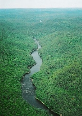
The Dumoine River is a river in western Quebec
with its source in Machin Lake near La Vérendrye Wildlife Reserve
. From Dumoine Lake, the river flows almost due south off the Canadian Shield
and empties into the Ottawa River
, just west of Rapides-des-Joachims, Quebec
, or Rolphton, Ontario. The river is 129 km long and drains a watershed of 5380 square kilometers (source: Atlas of Canada). This relatively short river compared to its drainage area indicates that the Dumoine has a strong current and many steep-gradient rapids.
Primarily known today for its white water canoeing
and fishing
, the river has a rich history from the native Indian era to exploration, fur trading
, and logging
. Development is very minimal along the river. Occasionally the river is crossed by logging roads but between kilometres 20 and 30 are several cottages.
This river is often grouped together with the Noire
and Coulonge River
s as three of a kind. All three are in the same area, have similar characteristics, and are very popular with whitewater
canoers
.
The river is named after the French family of Le Moynes.
For almost its entire length, the Dumoine River forms the boundary between the Pontiac
and Témiscamingue
regional county municipalities.
s that line the river on both sides) and Desire River respectively. A map of 1755 by Jacques-Nicolas Bellin
shows the name Acounagousin. Lotter, in 1762, and Carver, in 1776, named it likewise and they identify Lake Caouinagamic as its source.
The indigenous
people, coming from the Great Lakes
via the Mattawa
and French Rivers
, used the Dumoine to reach Trois-Rivières
and Quebec City
. From portage
to portage between the lakes and rivers, they would reach Lake Caoumaomic in the upper Mauricie
region and the Maskinongé River which would lead them to Lac Saint-Pierre
, thereby avoiding the Outaouais region and Montreal
, which were dominated by the Iroquois
.
In 1762, Alexander Henry passed by the mouth of the Dumoine when travelling to Sault Ste. Marie
. He wrote: "at the mouth of the Du Moine River, there is another fort or trading post where I found a small camp of Maskegon Indians with whom I have traded many items for fur."
The 1801 map of Alexander Mackenzie shows the layout of the Dumoine River but not all the way to its source. It is named after the trading post built at the river's mouth towards the end of French rule. The post was abandoned in 1761, and Fort Dumoine took over its activities around 1785. But after 1800 this fort did no longer give any signs of life.
On May 14, 2008, the Quebec Minister of Sustainable Development, Environment and Parks announced interim protection for 1445 square kilometres (557.9 sq mi) of the Dumoine River watershed. No industrial activities are allowed in the new interim protected area covering almost a third of the watershed and encompassed the Dumoine River from its head water to the Ottawa River.
(100 km, approximately 5–7 days), Lac Laforge (75 km, 4 days) or Lac Benoit (60 km, approximately 3–4 days). Access is by either float plane or logging road.
The range of rapids is large, from swifts to unrunnable falls. Beginning from Lac Dumoine, some of the more notable rapids are:
The section between Lac Benoit and Little Steel Falls (kilometres 60-50) is particularly nice, featuring many Class 2-3 drop-and-pool rapids typical of Canadian Shield rivers.
The final waterfall, called Ryan Chute, connects to the Ottawa River. This dangerous chute once had 35 pairs of hobnail boots nailed to surrounding trees as memorials to the loggers who had drowned.
All rapids and falls have well maintained portage
s. However, some minor CAT1 rapids lack portages, and spotters are recommended to access portages around several falls because of close proximity to dangerous waters.
The shore of Quebec at the end of the Dumoine River is undeveloped. So for take-out, it requires either crossing the Ottawa River (2.5 km wide at this point) to Driftwood Provincial Park
, or paddle 12 km downstream to Rapides-des-Joachims. Regardless, the Ottawa River is often very windy with large waves. Caution should be used.
There are many excellent guide maps and books available, with detailed descriptions and drawings of each rapid.
Quebec
Quebec or is a province in east-central Canada. It is the only Canadian province with a predominantly French-speaking population and the only one whose sole official language is French at the provincial level....
with its source in Machin Lake near La Vérendrye Wildlife Reserve
La Vérendrye Wildlife Reserve
La Vérendrye wildlife reserve is one of the largest reserves in the province of Quebec, Canada, covering 12,589 square kilometres of contiguous land and lake area . It is named after Pierre Gaultier de Varennes, sieur de La Vérendrye, a French-Canadian explorer...
. From Dumoine Lake, the river flows almost due south off the Canadian Shield
Canadian Shield
The Canadian Shield, also called the Laurentian Plateau, or Bouclier Canadien , is a vast geological shield covered by a thin layer of soil that forms the nucleus of the North American or Laurentia craton. It is an area mostly composed of igneous rock which relates to its long volcanic history...
and empties into the Ottawa River
Ottawa River
The Ottawa River is a river in the Canadian provinces of Ontario and Quebec. For most of its length, it now defines the border between these two provinces.-Geography:...
, just west of Rapides-des-Joachims, Quebec
Rapides-des-Joachims, Quebec
Rapides-des-Joachims is a municipality and village in western Quebec, Canada, part of Pontiac County in the Outaouais region. The village is situated on Rapides-des-Joachims Island on the Ottawa River, about 100 km northwest of Fort-Coulonge...
, or Rolphton, Ontario. The river is 129 km long and drains a watershed of 5380 square kilometers (source: Atlas of Canada). This relatively short river compared to its drainage area indicates that the Dumoine has a strong current and many steep-gradient rapids.
Primarily known today for its white water canoeing
Canoeing
Canoeing is an outdoor activity that involves a special kind of canoe.Open canoes may be 'poled' , sailed, 'lined and tracked' or even 'gunnel-bobbed'....
and fishing
Fishing
Fishing is the activity of trying to catch wild fish. Fish are normally caught in the wild. Techniques for catching fish include hand gathering, spearing, netting, angling and trapping....
, the river has a rich history from the native Indian era to exploration, fur trading
Fur trade
The fur trade is a worldwide industry dealing in the acquisition and sale of animal fur. Since the establishment of world market for in the early modern period furs of boreal, polar and cold temperate mammalian animals have been the most valued...
, and logging
Logging
Logging is the cutting, skidding, on-site processing, and loading of trees or logs onto trucks.In forestry, the term logging is sometimes used in a narrow sense concerning the logistics of moving wood from the stump to somewhere outside the forest, usually a sawmill or a lumber yard...
. Development is very minimal along the river. Occasionally the river is crossed by logging roads but between kilometres 20 and 30 are several cottages.
This river is often grouped together with the Noire
Noire River
The Noire River is a river in western Quebec, Canada. It runs in a south-eastern direction into the Ottawa River at Waltham, Quebec. It is named after the dark colour of its water ....
and Coulonge River
Coulonge River
The Coulonge River is a predominantly wilderness river in western Quebec, Canada. It is 217 km long, has a drainage area of 5060 km² , and runs in a general south-eastern direction from its headwaters in Lac au Barrage to the Ottawa River at Fort-Coulonge, Quebec...
s as three of a kind. All three are in the same area, have similar characteristics, and are very popular with whitewater
Whitewater
Whitewater is formed in a rapid, when a river's gradient increases enough to disturb its laminar flow and create turbulence, i.e. form a bubbly, or aerated and unstable current; the frothy water appears white...
canoers
Canoeing
Canoeing is an outdoor activity that involves a special kind of canoe.Open canoes may be 'poled' , sailed, 'lined and tracked' or even 'gunnel-bobbed'....
.
The river is named after the French family of Le Moynes.
For almost its entire length, the Dumoine River forms the boundary between the Pontiac
Pontiac Regional County Municipality, Quebec
Pontiac is a county regional municipality MRC Pontiac in the Outaouais region of Quebec, Canada. It should not be confused with the municipality of Pontiac, which is located inside the county regional municipality of Les Collines-de-l'Outaouais....
and Témiscamingue
Témiscamingue Regional County Municipality, Quebec
Témiscamingue is a county regional municipality in the Abitibi-Témiscamingue region of western Quebec, Canada. The county seat is Ville-Marie....
regional county municipalities.
History
The Algonquins named it Cakawitopikak Sipi and Ekonakwasi Sipi which means Alder River (for its many alderAlder
Alder is the common name of a genus of flowering plants belonging to the birch family . The genus comprises about 30 species of monoecious trees and shrubs, few reaching large size, distributed throughout the North Temperate Zone and in the Americas along the Andes southwards to...
s that line the river on both sides) and Desire River respectively. A map of 1755 by Jacques-Nicolas Bellin
Jacques-Nicolas Bellin
Jacques Nicolas Bellin was a French hydrographer, geographer, and member of the French intellectual group called the philosophes....
shows the name Acounagousin. Lotter, in 1762, and Carver, in 1776, named it likewise and they identify Lake Caouinagamic as its source.
The indigenous
Indigenous peoples of the Americas
The indigenous peoples of the Americas are the pre-Columbian inhabitants of North and South America, their descendants and other ethnic groups who are identified with those peoples. Indigenous peoples are known in Canada as Aboriginal peoples, and in the United States as Native Americans...
people, coming from the Great Lakes
Great Lakes
The Great Lakes are a collection of freshwater lakes located in northeastern North America, on the Canada – United States border. Consisting of Lakes Superior, Michigan, Huron, Erie, and Ontario, they form the largest group of freshwater lakes on Earth by total surface, coming in second by volume...
via the Mattawa
Mattawa River
The Mattawa River is a river in central Ontario, Canada. It flows east from Trout Lake east of North Bay and enters the Ottawa River at the town of Mattawa. Counting from the head of Trout Lake, it is 76 km in length...
and French Rivers
French River (Ontario)
The French River is a river in Central Ontario, Canada. It flows from Lake Nipissing west to Georgian Bay. The river largely follows the boundary between the Parry Sound District and the Sudbury District, and in most contexts is considered the dividing line between Northern Ontario and Southern...
, used the Dumoine to reach Trois-Rivières
Trois-Rivières
Trois-Rivières means three rivers in French and may refer to:in Canada*Trois-Rivières, the largest city in the Mauricie region of Quebec, Canada*Circuit Trois-Rivières, a racetrack in Trois-Rivières, Quebec...
and Quebec City
Quebec City
Quebec , also Québec, Quebec City or Québec City is the capital of the Canadian province of Quebec and is located within the Capitale-Nationale region. It is the second most populous city in Quebec after Montreal, which is about to the southwest...
. From portage
Portage
Portage or portaging refers to the practice of carrying watercraft or cargo over land to avoid river obstacles, or between two bodies of water. A place where this carrying occurs is also called a portage; a person doing the carrying is called a porter.The English word portage is derived from the...
to portage between the lakes and rivers, they would reach Lake Caoumaomic in the upper Mauricie
Mauricie
Mauricie is a traditional and current administrative region of Quebec. La Mauricie National Park is contained within the region, making it a prime tourist location. The region has a land area of 35,855.22 km² and a 2006 census population of 258,928 residents...
region and the Maskinongé River which would lead them to Lac Saint-Pierre
Lac Saint-Pierre
Lac Saint-Pierre is a lake in Quebec, Canada, located on the Saint Lawrence River between Sorel-Tracy and Trois-Rivières, downstream and east of Montreal. Including its shoreline, islands, and wetlands, the lake is a nature reserve...
, thereby avoiding the Outaouais region and Montreal
Montreal
Montreal is a city in Canada. It is the largest city in the province of Quebec, the second-largest city in Canada and the seventh largest in North America...
, which were dominated by the Iroquois
Iroquois
The Iroquois , also known as the Haudenosaunee or the "People of the Longhouse", are an association of several tribes of indigenous people of North America...
.
In 1762, Alexander Henry passed by the mouth of the Dumoine when travelling to Sault Ste. Marie
Sault Ste. Marie, Ontario
Sault Ste. Marie is a city on the St. Marys River in Algoma District, Ontario, Canada. It is the third largest city in Northern Ontario, after Sudbury and Thunder Bay, with a population of 74,948. The community was founded as a French religious mission: Sault either means "jump" or "rapids" in...
. He wrote: "at the mouth of the Du Moine River, there is another fort or trading post where I found a small camp of Maskegon Indians with whom I have traded many items for fur."
The 1801 map of Alexander Mackenzie shows the layout of the Dumoine River but not all the way to its source. It is named after the trading post built at the river's mouth towards the end of French rule. The post was abandoned in 1761, and Fort Dumoine took over its activities around 1785. But after 1800 this fort did no longer give any signs of life.
On May 14, 2008, the Quebec Minister of Sustainable Development, Environment and Parks announced interim protection for 1445 square kilometres (557.9 sq mi) of the Dumoine River watershed. No industrial activities are allowed in the new interim protected area covering almost a third of the watershed and encompassed the Dumoine River from its head water to the Ottawa River.
Paddling the Dumoine River
Paddling down the Dumoine is exciting and rewarding because of the large number of runnable rapids and its fast current. Trips usually start at Lac DumoineLac Dumoine
Lac Dumoine is a lake in Abitibi-Témiscamingue region, in southern Quebec, Canada....
(100 km, approximately 5–7 days), Lac Laforge (75 km, 4 days) or Lac Benoit (60 km, approximately 3–4 days). Access is by either float plane or logging road.
The range of rapids is large, from swifts to unrunnable falls. Beginning from Lac Dumoine, some of the more notable rapids are:
- km 64, "Fish Portage" (also called "Triple Play") - 3 sets of falls with Class 1 and 2 approaches.
- km 58, "Canoe Eater" - an interesting technical-Class 2 boulder run
- km 55, "Log Jam"
- km 54, "Little Steel"
- km 44, "Big Steel" - Class 3 to 2
- km 23, "Grande Chute" - impressive chute (not canoeable) followed by a Class 1 rapid
- km 17, "Red Pine" - series of rapids ranging from Class 1 to 3
- km 13, "Examination"
The section between Lac Benoit and Little Steel Falls (kilometres 60-50) is particularly nice, featuring many Class 2-3 drop-and-pool rapids typical of Canadian Shield rivers.
The final waterfall, called Ryan Chute, connects to the Ottawa River. This dangerous chute once had 35 pairs of hobnail boots nailed to surrounding trees as memorials to the loggers who had drowned.
All rapids and falls have well maintained portage
Portage
Portage or portaging refers to the practice of carrying watercraft or cargo over land to avoid river obstacles, or between two bodies of water. A place where this carrying occurs is also called a portage; a person doing the carrying is called a porter.The English word portage is derived from the...
s. However, some minor CAT1 rapids lack portages, and spotters are recommended to access portages around several falls because of close proximity to dangerous waters.
The shore of Quebec at the end of the Dumoine River is undeveloped. So for take-out, it requires either crossing the Ottawa River (2.5 km wide at this point) to Driftwood Provincial Park
Driftwood Provincial Park
Driftwood Provincial Park is a provincial park on the south shore of the Ottawa River, about 40 km west of Deep River, Ontario. It is administered by Ontario Parks which classifies it as a recreation park....
, or paddle 12 km downstream to Rapides-des-Joachims. Regardless, the Ottawa River is often very windy with large waves. Caution should be used.
There are many excellent guide maps and books available, with detailed descriptions and drawings of each rapid.