
Watauga Dam
Encyclopedia
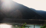
Watauga Dam is a hydroelectric and flood control dam on the Watauga River
in Carter County
, in the U.S. state of Tennessee
. It is owned and operated by the Tennessee Valley Authority
, which built the dam in the 1940s as part of efforts to control flooding in the Tennessee River
watershed. At 318 feet (96.9 m), Watauga is the second-highest dam in the TVA system (behind only Fontana
), and at the time of its completion was one of the highest earth-and-rock dams in the United States. The dam impounds the Watauga Lake
of 6430 acres (26 km²), and its tailwaters feed into Wilbur Lake. The Appalachian Trail
crosses the top of Watauga Dam.
Watauga Dam is named after the Watauga River. The river was named after a Cherokee
settlement— the Watauga Old Fields— once located along the river at modern Elizabethton
.
and 10 miles (16.1 km) upstream from Elizabethton. Watauga Lake stretches for 16.7 miles (26.9 km) along the river, nearly reaching the Tennessee-North Carolina
state line, and includes parts of Carter County and Johnson County in Tennessee. Roan Creek
, Cobb Creek, and the Elk River
form substantial embayments along the reservoir.
Watauga's powerhouse is located nearly a mile downstream from the dam, and is connected to the reservoir intake by a 3700 feet (1,127.8 m) tunnel. Just above the powerhouse, the tunnel splits into two steel conduits that carry the water to a valve house just above the turbines.
 The hydroelectric potential of the Watauga River had been recognized since the early 1900s, when the Watauga Power Company built Wilbur Dam
3 miles (4.8 km) downstream from the modern Watauga Dam site. In the 1920s, the Holston River Power Company began making plans for a large-scale dam-building project in the South Fork Holston River watershed, and had identified two possible dam sites along the Watauga, one of which was the current site of Watauga Dam (the company called it the "Cardens Bluff" site). In the early 1940s, the Tennessee Valley Authority— which had assumed oversight of flood control operations in the Tennessee River
watershed in the previous decade, suggested a dam at the Cardens Bluff site to provide badly needed flood storage and help with the region's World War II
energy demands. The dam project garnered widespread local support, especially from Elizabethton, which had been ravaged by a flood in 1940. The Watauga project was authorized December 17, 1941, and work on the dam began on February 16, 1942.
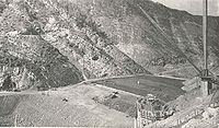 The construction of Watauga Dam and its reservoir required the purchase of 11700 acres (47 km²) of land,
1663 acres (6.7 km²) of which had to be cleared. 761 families, 1,281 graves, and 55 miles (88.5 km) of roads had to be relocated, and three new bridges were built. Wilbur Dam, located just 3 miles (4.8 km) downstream, had to be raised and outfitted with a new spillway. The town of Butler
had to be moved. In October 1942, the U.S. War Production Board
ordered TVA to halt the Watauga project, deeming it unnecessary for the nation's wartime needs. TVA spent several weeks securing the dam site and tunnel, and the project was set aside until the end of the war. Construction proceeded on May 22, 1946.
Watauga Dam was completed and its gates opened December 1, 1948. The dam's first generator went online August 30, 1949, and the second went online September 29, 1949. The total cost of the Watauga project was just over $32 million.
Watauga River
The Watauga River is a large stream of western North Carolina and East Tennessee. It is 60 miles long with its headwaters on the slopes of Grandfather Mountain and Peak Mountain in Watauga County, North Carolina.-Hydrography:...
in Carter County
Carter County, Tennessee
Carter County is a county located in the U.S. state of Tennessee. As of 2010, the population was 57,424. Its county seat is Elizabethton.Carter County is part of the Johnson City Metropolitan Statistical Area, which is a component of the Johnson City–Kingsport–Bristol, TN-VA Combined...
, in the U.S. state of Tennessee
Tennessee
Tennessee is a U.S. state located in the Southeastern United States. It has a population of 6,346,105, making it the nation's 17th-largest state by population, and covers , making it the 36th-largest by total land area...
. It is owned and operated by the Tennessee Valley Authority
Tennessee Valley Authority
The Tennessee Valley Authority is a federally owned corporation in the United States created by congressional charter in May 1933 to provide navigation, flood control, electricity generation, fertilizer manufacturing, and economic development in the Tennessee Valley, a region particularly affected...
, which built the dam in the 1940s as part of efforts to control flooding in the Tennessee River
Tennessee River
The Tennessee River is the largest tributary of the Ohio River. It is approximately 652 miles long and is located in the southeastern United States in the Tennessee Valley. The river was once popularly known as the Cherokee River, among other names...
watershed. At 318 feet (96.9 m), Watauga is the second-highest dam in the TVA system (behind only Fontana
Fontana Dam
Fontana Dam is a hydroelectric dam on the Little Tennessee River in Swain and Graham counties, North Carolina, USA. The dam is operated by the Tennessee Valley Authority, which built the dam in the early 1940s to accommodate the skyrocketing electricity demands in the Tennessee Valley at the...
), and at the time of its completion was one of the highest earth-and-rock dams in the United States. The dam impounds the Watauga Lake
Watauga Lake
Watauga Lake, located southeast of Elizabethton, Tennessee, was created by the Tennessee Valley Authority with the completion of the TVA Watauga Dam and Reservoir....
of 6430 acres (26 km²), and its tailwaters feed into Wilbur Lake. The Appalachian Trail
Appalachian Trail
The Appalachian National Scenic Trail, generally known as the Appalachian Trail or simply the AT, is a marked hiking trail in the eastern United States extending between Springer Mountain in Georgia and Mount Katahdin in Maine. It is approximately long...
crosses the top of Watauga Dam.
Watauga Dam is named after the Watauga River. The river was named after a Cherokee
Cherokee
The Cherokee are a Native American people historically settled in the Southeastern United States . Linguistically, they are part of the Iroquoian language family...
settlement— the Watauga Old Fields— once located along the river at modern Elizabethton
Elizabethton, Tennessee
Elizabethton is the county seat of Carter County, Tennessee, United States. Elizabethton is also the historical site both of the first independent American government located west of both the Eastern Continental Divide and the original thirteen British American colonies.Elizabethton is also the...
.
Location
Watauga Dam is located 37 miles (59.5 km) above the mouth of the Watauga, at a point where the westward-flowing river veers north to slice a water gap through the middle of Iron Mountain. The dam is about 5 miles (8 km) downstream from Butler, TennesseeButler, Tennessee
Butler is an unincorporated community in Johnson County in the northeastern corner of the U.S. state of Tennessee. It is located near Watauga Lake. Butler is served by a post office, assigned ZIP Code 37640.-Early history:...
and 10 miles (16.1 km) upstream from Elizabethton. Watauga Lake stretches for 16.7 miles (26.9 km) along the river, nearly reaching the Tennessee-North Carolina
North Carolina
North Carolina is a state located in the southeastern United States. The state borders South Carolina and Georgia to the south, Tennessee to the west and Virginia to the north. North Carolina contains 100 counties. Its capital is Raleigh, and its largest city is Charlotte...
state line, and includes parts of Carter County and Johnson County in Tennessee. Roan Creek
Roan Creek
Roan Creek rises on the Tennessee and North Carolina border, in Johnson County, Tennessee, near the town of Trade, Tennessee. It flows through Cherokee National Forest to join the Watauga River in Watauga Lake, the reservoir behind Watauga Dam....
, Cobb Creek, and the Elk River
Elk River (North Carolina)
The Elk River is a large stream in the North Carolina High Country and East Tennessee. The headwaters begin from the Northwestern slopes of Peak Mountain in Avery County, North Carolina and end at the Watauga River in Carter County, Tennessee.-Hydrography:...
form substantial embayments along the reservoir.
Capacity
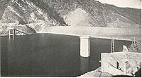
Watauga Dam is an earth-and-rock dam 318 feet (96.9 m) high and 900 feet (274.3 m) long, and has a generating capacity of 57,600 kilowatts. The dam's fixed-crest morning glory spillway has a maximum discharge of 73200 cuft/s. Watauga Lake has 106 miles (170.6 km) of shoreline and a flood storage capacity of 152829 acre.ft. The reservoir's operating levels vary by about 9 feet (2.7 m) in a typical year.Watauga's powerhouse is located nearly a mile downstream from the dam, and is connected to the reservoir intake by a 3700 feet (1,127.8 m) tunnel. Just above the powerhouse, the tunnel splits into two steel conduits that carry the water to a valve house just above the turbines.
Background and construction
Wilbur Dam
Wilbur Dam is a hydroelectric dam on the Watauga River in Carter County, in the U.S. state of Tennessee. It is one of two dams on the river owned and operated by the Tennessee Valley Authority. The dam impounds Wilbur Lake, which extends for about up the Watauga to the base of Watauga Dam...
3 miles (4.8 km) downstream from the modern Watauga Dam site. In the 1920s, the Holston River Power Company began making plans for a large-scale dam-building project in the South Fork Holston River watershed, and had identified two possible dam sites along the Watauga, one of which was the current site of Watauga Dam (the company called it the "Cardens Bluff" site). In the early 1940s, the Tennessee Valley Authority— which had assumed oversight of flood control operations in the Tennessee River
Tennessee River
The Tennessee River is the largest tributary of the Ohio River. It is approximately 652 miles long and is located in the southeastern United States in the Tennessee Valley. The river was once popularly known as the Cherokee River, among other names...
watershed in the previous decade, suggested a dam at the Cardens Bluff site to provide badly needed flood storage and help with the region's World War II
World War II
World War II, or the Second World War , was a global conflict lasting from 1939 to 1945, involving most of the world's nations—including all of the great powers—eventually forming two opposing military alliances: the Allies and the Axis...
energy demands. The dam project garnered widespread local support, especially from Elizabethton, which had been ravaged by a flood in 1940. The Watauga project was authorized December 17, 1941, and work on the dam began on February 16, 1942.
1663 acres (6.7 km²) of which had to be cleared. 761 families, 1,281 graves, and 55 miles (88.5 km) of roads had to be relocated, and three new bridges were built. Wilbur Dam, located just 3 miles (4.8 km) downstream, had to be raised and outfitted with a new spillway. The town of Butler
Butler, Tennessee
Butler is an unincorporated community in Johnson County in the northeastern corner of the U.S. state of Tennessee. It is located near Watauga Lake. Butler is served by a post office, assigned ZIP Code 37640.-Early history:...
had to be moved. In October 1942, the U.S. War Production Board
War Production Board
The War Production Board was established as a government agency on January 16, 1942 by executive order of Franklin D. Roosevelt.The purpose of the board was to regulate the production and allocation of materials and fuel during World War II in the United States...
ordered TVA to halt the Watauga project, deeming it unnecessary for the nation's wartime needs. TVA spent several weeks securing the dam site and tunnel, and the project was set aside until the end of the war. Construction proceeded on May 22, 1946.
Watauga Dam was completed and its gates opened December 1, 1948. The dam's first generator went online August 30, 1949, and the second went online September 29, 1949. The total cost of the Watauga project was just over $32 million.
External links
- Watauga Reservoir — official TVA site