Farmington River
Encyclopedia
_map.jpg)
Connecticut
Connecticut is a state in the New England region of the northeastern United States. It is bordered by Rhode Island to the east, Massachusetts to the north, and the state of New York to the west and the south .Connecticut is named for the Connecticut River, the major U.S. river that approximately...
, with major tributaries extending into southwest Massachusetts
Massachusetts
The Commonwealth of Massachusetts is a state in the New England region of the northeastern United States of America. It is bordered by Rhode Island and Connecticut to the south, New York to the west, and Vermont and New Hampshire to the north; at its east lies the Atlantic Ocean. As of the 2010...
. Via its longest branch (the West Branch), the Farmington's length increases to 80.4 miles (129.4 km), making it the Connecticut River's longest tributary by a mere 2.3 miles (3.7 km) over the major river directly to its north, the Westfield River
Westfield River
The Westfield River in Metropolitan Springfield, Massachusetts, is a major tributary of the Connecticut River in Hampden County, Massachusetts. The Westfield River has four major tributary branches that confluence in the City of Westfield, for which the river is named...
. The Farmington River's watershed
Drainage basin
A drainage basin is an extent or an area of land where surface water from rain and melting snow or ice converges to a single point, usually the exit of the basin, where the waters join another waterbody, such as a river, lake, reservoir, estuary, wetland, sea, or ocean...
covers 609 square mile. The river historically played an important role in small-scale manufacturing in towns alongside it, but it is now mainly used for recreation and drinking water. The Farmington River Watershed Association is a non-profit organization for conservation and preservation of this river.
Its two main branches start in southwestern Massachusetts. The West Branch starts in Becket, Massachusetts
Becket, Massachusetts
Becket is a town in Berkshire County, Massachusetts, United States. It is part of the Pittsfield, Massachusetts Metropolitan Statistical Area. The population was 1,779 at the 2010 census.- History :...
and flows southeasterly to Otis, Massachusetts
Otis, Massachusetts
Otis is a town in Berkshire County, Massachusetts, United States. It is part of the Pittsfield, Massachusetts Metropolitan Statistical Area. The population was 1,365 at the 2000 census....
. A 14 miles (22.5 km) portion of the western branch has been designated a National Wild and Scenic River
National Wild and Scenic River
National Wild and Scenic River is a designation for certain protected areas in the United States.The National Wild and Scenic Rivers Act was an outgrowth of the recommendations of a Presidential commission, the Outdoor Recreation Resources Review Commission...
. The eastern branch is now mostly covered by the Barkhamsted Reservoir. The two branches join in New Hartford, Connecticut
New Hartford, Connecticut
New Hartford is a town in Litchfield County, Connecticut, United States. The population was 6,088 at the 2000 census. The town center is also defined by the U.S. Census Bureau as a census-designated place . The town is mainly a rural community consisting of farms, homes, and parks...
. The upper reaches of the river flow mostly southward, but the river turns northward in Farmington, Connecticut
Farmington, Connecticut
Farmington is a town located in Hartford County in the Farmington Valley area of central Connecticut in the United States. The population was 25,340 at the 2010 census. It is home to the world headquarters of several large corporations including Carrier Corporation, Otis Elevator Company, and Carvel...
and then runs mostly north and east until it flows into the Connecticut River
Connecticut River
The Connecticut River is the largest and longest river in New England, and also an American Heritage River. It flows roughly south, starting from the Fourth Connecticut Lake in New Hampshire. After flowing through the remaining Connecticut Lakes and Lake Francis, it defines the border between the...
near the Loomis Chaffee School in Windsor, Connecticut
Windsor, Connecticut
Windsor is a town in Hartford County, Connecticut, United States, and was the first English settlement in the state. It lies on the northern border of Connecticut's capital, Hartford. The population was estimated at 28,778 in 2005....
.
Boating
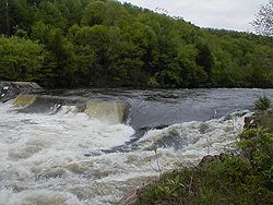
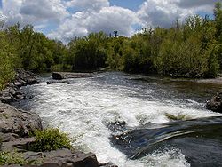
There are several whitewater sections. One of these, the so-called "Upper Farmington" section of the West Branch in New Boston, Massachusetts, is about 7 miles (11 km) long. It is Class 2 through farm and woods scenery to an iron bridge, where kayak and canoe slalom races are held. Below the bridge the river becomes Class 3-4, very technical at low water, and technical and pushy at higher water, with a short gorge with several abrupt drops. The biggest of these is about four feet at Decoration Rock. Below, the river continues fast and technical with many rocks and constant maneuvering required. The river is continuously rapid, leading through larger drops at Battering Ram rapid and Corkscrew. Eventually it flattens to Class 2 until a final, ledge rapid at Bear's Den, just above the reservoir. The Upper Farmington is barely runnable (very scratchy with many exposed rocks and pinning possibilities) during fall dam releases, and is a much better run at levels of about 600 cubic feet per second (16,990 l/s), or about 5 feet (1.5 m) on the internet gauge for that section.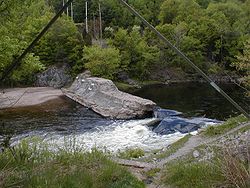
Tariffville, Connecticut
Tariffville is a neighborhood and census-designated place in the town of Simsbury in Hartford County, Connecticut, United States. It is a popular location for whitewater paddlers who use the Farmington River...
, one mile (1.6 km) of technical Class 3 water which is runnable all year round. The river is normally paddled at levels between 1.5 and 2.75 feet (45–75 cm) on the internet gauge ; above 2.5 feet (75 cm) it becomes significantly heavier and more dangerous. This section includes the famous T-ville Hole, where kayakers can practice hole surfing and freestyle moves above a flat pool. Below the Hole is a broken dam, where the river funnels through an abrupt four foot drop into a large wave. This area is popular with swimmers in summer, and it is risky due to heavy currents and undercut rocks. There have been at least three fatal drownings in the Tariffville Gorge section, primarily people who were not properly prepared or trained for the heavy rapids and pinning obstacles in the gorge. Paddlers without helmets, lifejackets and Class 3 whitewater skills should end downriver trips at Tariffville Park, just above the start of the gorge.
Dams and power generation
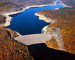
The largest dam on the east branch is the Saville Dam
Saville Dam
Saville Dam is an earthen embankment dam with masonry work on the eastern branch of the Farmington River 4 km southwest of Barkhamsted, Connecticut. The dam is 135 ft. tall and 1,950 ft. long and has an uncontrolled spillway on its western portion...
, which impounds the Barkhamsted Reservoir.
The Rainbow Dam, a 68 feet (20.7 m) dam with a hydroelectric generator and a fish ladder
Fish ladder
A fish ladder, also known as a fishway, fish pass or fish steps, is a structure on or around artificial barriers to facilitate diadromous fishes' natural migration. Most fishways enable fish to pass around the barriers by swimming and leaping up a series of relatively low steps into the waters on...
, dams the river at Windsor, a few miles before the river flows into the Connecticut River.
A number of other dams have been built on the river since European settlement, usually to power mills and other industry. A few, such as in Collinsville, are still mostly intact.
Water released from or flowing over the Otis Reservoir
Otis Reservoir
Otis Reservoir is a reservoir located primarily in Otis, Massachusetts. Small portions are also in Tolland, MA, and Blandford, MA. The lake is popular for boating, swimming, fishing, water skiing, snowmobiling, camping, and water-related recreation. Fish include lake trout, bass, white perch,...
dam enters the Farmington River just North of Reservoir Road in Otis, Massachusetts. Significant quantities of water are released during the fall in order to drop the reservoir water level for the winter.
History
The Spoonville dam, built in the 19th century, just below the Tariffville Gorge in East Granby, was breached in the flood of 1955, and still remains as a partial dam in 2010, although there are discussions to remove the remaining portion of the dam. The dam, as well as the bridge crossing the Farmington River downstream at Route 187Connecticut Route 187
Route 187 is a secondary state route in the U.S. states of Connecticut and Massachusetts. It begins in the city of Hartford at Albany Avenue , travels north through the towns of Bloomfield, Windsor, East Granby and Suffield until the Connecticut-Massachusetts state line...
, got its name from the silver plating factory erected in 1840 on the north bank of the river. It was the first factory of its kind in the United States.