

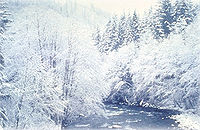
Salmon River (Clackamas County, Oregon)
Encyclopedia
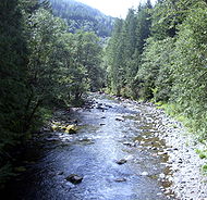
River
A river is a natural watercourse, usually freshwater, flowing towards an ocean, a lake, a sea, or another river. In a few cases, a river simply flows into the ground or dries up completely before reaching another body of water. Small rivers may also be called by several other names, including...
in Oregon
Oregon
Oregon is a state in the Pacific Northwest region of the United States. It is located on the Pacific coast, with Washington to the north, California to the south, Nevada on the southeast and Idaho to the east. The Columbia and Snake rivers delineate much of Oregon's northern and eastern...
's Cascade Range
Cascade Range
The Cascade Range is a major mountain range of western North America, extending from southern British Columbia through Washington and Oregon to Northern California. It includes both non-volcanic mountains, such as the North Cascades, and the notable volcanoes known as the High Cascades...
and drains a portion of southwestern Mount Hood
Mount Hood
Mount Hood, called Wy'east by the Multnomah tribe, is a stratovolcano in the Cascade Volcanic Arc of northern Oregon. It was formed by a subduction zone and rests in the Pacific Northwest region of the United States...
.
The entire length of the river is protected National Wild and Scenic River
National Wild and Scenic River
National Wild and Scenic River is a designation for certain protected areas in the United States.The National Wild and Scenic Rivers Act was an outgrowth of the recommendations of a Presidential commission, the Outdoor Recreation Resources Review Commission...
, the only such river in the contiguous 48 states.
Several portions are in protected Wilderness
Wilderness Act
The Wilderness Act of 1964 was written by Howard Zahniser of The Wilderness Society. It created the legal definition of wilderness in the United States, and protected some 9 million acres of federal land. The result of a long effort to protect federal wilderness, the Wilderness Act was signed...
. It is affluent to the Sandy River
Sandy River (Oregon)
The Sandy River is a tributary of the Columbia River in northwestern Oregon in the United States. Measured by a United States Geological Survey gauge downstream of the Sandy's confluence with the Bull Run River, from the mouth, the river's average discharge is . The maximum daily recorded flow...
.
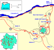
Course
Sickle
A sickle is a hand-held agricultural tool with a variously curved blade typically used for harvesting grain crops or cutting succulent forage chiefly for feeding livestock . Sickles have also been used as weapons, either in their original form or in various derivations.The diversity of sickles that...
-shaped with the point facing north at Mount Hood
Mount Hood
Mount Hood, called Wy'east by the Multnomah tribe, is a stratovolcano in the Cascade Volcanic Arc of northern Oregon. It was formed by a subduction zone and rests in the Pacific Northwest region of the United States...
and the handle facing west.
The headwaters are on the Mount Hood's south face at the foot of Palmer Glacier
Palmer Glacier
The Palmer Glacier is a glacier located on the upper slopes of Mount Hood in the U.S. state of Oregon. It is on the south side of the mountain ranging in elevation from about 6,200 to 9,300 ft , and was named for Joel Palmer, an Oregon pioneer...
east of Silcox Hut
Silcox Hut
The Silcox Hut is a small rustic mid-mountain lodge located at elevation on Mount Hood, Oregon, United States. It is approximately vertical above Timberline Lodge and roughly one mile distance directly up the mountain....
.
The canyon is visible most of the year—when not snowfilled—where it crosses the Pacific Crest Trail
Pacific Crest Trail
The Pacific Crest Trail is a long-distance mountain hiking and equestrian trail on the Western Seaboard of the United States. The southern terminus is at the California border with Mexico...
at 5980 ft (1,822.7 m)
The River continues directly southward for a few miles and remains east of Timberline Road.
As it descends below 4500 feet (1,371.6 m), it turns southwest, and continues under Oregon Route 35 (elev. 3600 ft (1,097.3 m)) just east of the junction with U.S. Route 26, and crosses under Route 26 as well.
The West Fork begins in the Timberline Lodge ski area
Timberline Lodge ski area
Timberline Lodge ski area is the ski and snowboarding area of Timberline Lodge, a National Historic Landmark in the U.S state of Oregon. It is one of a few ski lodges in the United States with most of the skiable terrain below the main lodge...
under the Pucci chairlift
Chairlift
An elevated passenger ropeway, or chairlift, is a type of aerial lift, which consists of a continuously circulating steel cable loop strung between two end terminals and usually over intermediate towers, carrying a series of chairs...
.
It flows SSW and is joined by natural cold springs at the 5000 foot (1525 m) level, continues SSW and crosses under Hwy 26 just west of the Hwy 35 junction.
Just after they cross Hwy 26, the West Fork and Salmon River join, and a half mile (1 km) later, the Salmon is joined by the East Fork Salmon River which comes out of a steep valley just north of, and below, Barlow Pass
Barlow Pass (Oregon)
Barlow Pass is a mountain pass in the Cascades in Oregon, on the Oregon Trail, and a major milestone of the Barlow Road. It is the crest of the Cascade Mountains: the dividing line between watersheds of the Deschutes River and those that flow into the Sandy River.It is located on the southern...
.
The combined river flows directly south through Red Top Meadow for about three miles (5 km) and begins meandering slightly through Salmon River Meadows, elev 3320 ft (1010 m).
At the south end, the river is joined by Ghost Creek and turns WSW for about four miles (6 km) before meeting Mud Creek, which flows from Trillium Lake
Trillium Lake
Trillium Lake is a lake situated south-southwest of Mount Hood in the U.S. state of Oregon. It is formed by a dam at the headwaters of Mud Creek, tributary to the Salmon River. It was created by the state Department of Fish and Wildlife in 1960....
. About 1.5 miles (2.4 km) downstream from Mud Creek, it enters the eastern boundary of Salmon–Huckleberry Wilderness
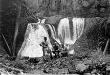
It turns NW, flows over a series of waterfalls ranging from 15 to 80 ft (4.6 to 24.4 m) high: Stein Falls and Split Falls, and turns directly north to go 90 degrees counter clockwise around a volcanic prominence. South of the Salmon River, Iron Creek merges with Tumbling Creek and flows over Hideaway Falls a quarter mile south of the junction between Tumbling, Swift, and Kinzel Creeks and the Salmon River, at elevation 2200.
), and Final Falls which are at the foot of cliffs to the south—Salmon River Canyon.
A half mile later, Copper Creek joins from the south and, a mile later, Bighorn Creek joins from the south and the river leaves the wilderness area.
About 1.5 miles (2.4 km) later, the South Fork Salmon River—which drains about twenty-five square miles of rugged mountains northeast of Squaw Mountain—joins a mile above Green Canyon Campground, and enters the last eleven miles (18 km) on a comparatively level grade with occasional short rapids.
It meanders through several areas with houses near Welches
Welches, Oregon
Welches is an unincorporated community in Clackamas County, Oregon, United States. It is located within the Mount Hood Corridor between Zigzag and Wemme along U.S. Route 26. It is one of the communities that make up the Villages at Mount Hood....
and Wemme
Wemme, Oregon
Wemme is an unincorporated community in Clackamas County, Oregon, United States. It is located within the Mount Hood Corridor, between Welches and Brightwood along U.S. Route 26. It is one of the communities that make up the Villages at Mount Hood....
, then goes through Wildwood Recreation Site
Wildwood Recreation Site
The Wildwood Recreation Site is a natural recreation area surrounded by the Mount Hood National Forest in northern Oregon, USA. It contains of natural rainforest and five miles of interpretive trail along the Salmon River. It features Cascade Streamwatch, an underwater viewport into a mountain...
which provides educational and recreational experiences.
It crosses (again) under U.S. Route 26 and merges with the Sandy River
Sandy River (Oregon)
The Sandy River is a tributary of the Columbia River in northwestern Oregon in the United States. Measured by a United States Geological Survey gauge downstream of the Sandy's confluence with the Bull Run River, from the mouth, the river's average discharge is . The maximum daily recorded flow...
near the community of Brightwood
Brightwood, Oregon
Brightwood is an unincorporated community within the Mount Hood Corridor in Clackamas County, Oregon, United States. It is located between Wemme and Sandy just off of U.S. Route 26 at an elevation of 355 meters. It is one of the communities that make up the Villages at Mount Hood.A post office...
.
Wildlife
The lower canyons have Black BearAmerican black bear
The American black bear is a medium-sized bear native to North America. It is the continent's smallest and most common bear species. Black bears are omnivores, with their diets varying greatly depending on season and location. They typically live in largely forested areas, but do leave forests in...
, mule deer
Mule Deer
The mule deer is a deer indigenous to western North America. The Mule Deer gets its name from its large mule-like ears. There are believed to be several subspecies, including the black-tailed deer...
, cougar, badger
Badger
Badgers are short-legged omnivores in the weasel family, Mustelidae. There are nine species of badger, in three subfamilies : Melinae , Mellivorinae , and Taxideinae...
, fisher
Fisher (animal)
The fisher is a medium-size mammal native to North America. It is a member of the mustelid family, commonly referred to as the weasel family. The fisher is closely related to but larger than the American Marten...
, and marten
Marten
The martens constitute the genus Martes within the subfamily Mustelinae, in family Mustelidae.-Description:Martens are slender, agile animals, adapted to living in taigas, and are found in coniferous and northern deciduous forests across the northern hemisphere. They have bushy tails, and large...
. Dense Western Hemlock
Western Hemlock
Tsuga heterophylla. the Western Hemlock, is a species of hemlock native to the west coast of North America, with its northwestern limit on the Kenai Peninsula, Alaska, and its southeastern limit in northern Sonoma County, California.-Habitat:...
, Douglas-fir
Douglas-fir
Douglas-fir is one of the English common names for evergreen coniferous trees of the genus Pseudotsuga in the family Pinaceae. Other common names include Douglas tree, and Oregon pine. There are five species, two in western North America, one in Mexico, and two in eastern Asia...
are mixed with Western Red Cedar, Red Alder
Red Alder
Alnus rubra, the Red alder, is a deciduous broadleaf tree native to western North America.-Description:It is the largest species of alder in North America and one of the largest in the world, reaching heights of 20–35 m. The official tallest red alder stands 32 meters tall in Clatsop County, Oregon...
, and Vine Maple
Vine Maple
Acer circinatum is a species of maple native to western North America, from southwest British Columbia to northern California, always within 300 km of the Pacific Ocean coast....
. The rare Alaska Cedar is found in patches around the Salmon River Meadows.
The river is likely named for its abundant anadromous fish: Steelhead, Cutthroat trout
Cutthroat trout
The cutthroat trout is a species of freshwater fish in the salmon family of order Salmoniformes. It is one of the many fish species colloquially known as trout...
, Chinook salmon
Chinook salmon
The Chinook salmon, Oncorhynchus tshawytscha, is the largest species in the pacific salmon family. Other commonly used names for the species include King salmon, Quinnat salmon, Spring salmon and Tyee salmon...
, and Coho salmon
Coho salmon
The Coho salmon, Oncorhynchus kisutch, is a species of anadromous fish in the salmon family. Coho salmon are also known as silver salmon or "silvers". It is the state animal of Chiba, Japan.-Description:...
.
Recreation
Oregonkayaking.net saysSee also
- Salmon River National Recreation TrailSalmon River National Recreation TrailThe Salmon River National Recreation Trail is a National Recreation Trail in Oregon's northern Cascade Mountains among the foothills of Mount Hood. About of the trail's length is within the Salmon-Huckleberry Wilderness, and parallels the Salmon River, though often along the top of a high...
- List of Oregon rivers
- List of National Wild and Scenic Rivers