

White River (Oregon)
Encyclopedia
Oregon
Oregon is a state in the Pacific Northwest region of the United States. It is located on the Pacific coast, with Washington to the north, California to the south, Nevada on the southeast and Idaho to the east. The Columbia and Snake rivers delineate much of Oregon's northern and eastern...
in the United States
United States
The United States of America is a federal constitutional republic comprising fifty states and a federal district...
. It drains a scenic mountainous area of the Columbia Plateau
Columbia Plateau
The Columbia Plateau is a geologic and geographic region that lies across parts of the U.S. states of Washington, Oregon, and Idaho. It is a wide flood basalt plateau between the Cascade Range and the Rocky Mountains, cut through by the Columbia River...
on the east side of the Cascade Range
Cascade Range
The Cascade Range is a major mountain range of western North America, extending from southern British Columbia through Washington and Oregon to Northern California. It includes both non-volcanic mountains, such as the North Cascades, and the notable volcanoes known as the High Cascades...
southeast of Mount Hood
Mount Hood
Mount Hood, called Wy'east by the Multnomah tribe, is a stratovolcano in the Cascade Volcanic Arc of northern Oregon. It was formed by a subduction zone and rests in the Pacific Northwest region of the United States...
. In the 1840s, a section of the Oregon Trail
Oregon Trail
The Oregon Trail is a historic east-west wagon route that connected the Missouri River to valleys in Oregon and locations in between.After 1840 steam-powered riverboats and steamboats traversing up and down the Ohio, Mississippi and Missouri rivers sped settlement and development in the flat...
called the Barlow Road
Barlow Road
The Barlow Road is a historic road in what is now the U.S. state of Oregon. It was built in 1846 by Sam Barlow and Philip Foster, with authorization of the Provisional Legislature of Oregon, and served as the last overland segment of the Oregon Trail...
passed through the river corridor. This section of the road is listed on the National Register of Historic Places.
Geography
The White River originates in the high Cascades in western Wasco CountyWasco County, Oregon
Wasco County is a county located in the U.S. state of Oregon. The county is named for a local tribe of Native Americans, the Wasco, a Chinook tribe who lived on the south side of the Columbia River. In 2010, its population was 25,213...
, in the Mount Hood National Forest
Mount Hood National Forest
The Mount Hood National Forest is located east of the city of Portland, Oregon, and the northern Willamette River valley. The Forest extends south from the Columbia River Gorge across more than of forested mountains, lakes and streams to the Olallie Scenic Area, a high lake basin under the slopes...
on the southeast flank of Mount Hood
Mount Hood
Mount Hood, called Wy'east by the Multnomah tribe, is a stratovolcano in the Cascade Volcanic Arc of northern Oregon. It was formed by a subduction zone and rests in the Pacific Northwest region of the United States...
. The headwaters are just below White River Glacier
White River Glacier (Oregon)
White River Glacier is an alpine glacier located on the south slopes of Mount Hood in the U.S. state of Oregon. It ranges in elevation from about 6,200 to 10,000 ft . It is among the best known of the twelve glaciers on the mountain, and the lower reaches are a popular destination for Nordic...
in White River Canyon, the steep canyon between Timberline Lodge and Mount Hood Meadows ski areas. It flows southeast, under Oregon Route 35, another 12 miles (19.3 km) southeast then east for 8 miles (12.9 km) before turning east-northeast past Tygh Valley
Tygh Valley, Oregon
* Annual Average High Temperatures: 86 °F 41 °F * Annual Average Low Temperatures 50 °F 26 °F * Highest Recorded Temperature: 110 °F * Lowest Recorded Temperature: -28 °F...
. It enters the Deschutes River from the west approximately 20 mi (32 km) southeast of The Dalles
The Dalles, Oregon
The Dalles is the largest city and county seat of Wasco County, Oregon, United States. The name of the city comes from the French word dalle The Dalles is the largest city and county seat of Wasco County, Oregon, United States. The name of the city comes from the French word dalle The Dalles is...
.
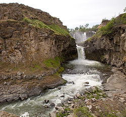
In its lower course near Tygh Valley the river plunges over a 90 ft (27 m) basalt
Basalt
Basalt is a common extrusive volcanic rock. It is usually grey to black and fine-grained due to rapid cooling of lava at the surface of a planet. It may be porphyritic containing larger crystals in a fine matrix, or vesicular, or frothy scoria. Unweathered basalt is black or grey...
shelf in White River Falls State Park
White River Falls State Park
White River Falls State Park is a state park in north central Oregon. It is located by road south of The Dalles and east of Tygh Valley.The focus of the park is the falls where wild and scenic White River plunges from a basalt shelf...
. The falls were used for hydroelectricity
Hydroelectricity
Hydroelectricity is the term referring to electricity generated by hydropower; the production of electrical power through the use of the gravitational force of falling or flowing water. It is the most widely used form of renewable energy...
in the surrounding counties from 1910 until the completion of The Dalles Dam on the Columbia River
Columbia River
The Columbia River is the largest river in the Pacific Northwest region of North America. The river rises in the Rocky Mountains of British Columbia, Canada, flows northwest and then south into the U.S. state of Washington, then turns west to form most of the border between Washington and the state...
in 1960.
Wild and Scenic
National Wild and Scenic River
National Wild and Scenic River is a designation for certain protected areas in the United States.The National Wild and Scenic Rivers Act was an outgrowth of the recommendations of a Presidential commission, the Outdoor Recreation Resources Review Commission...
by the United States Congress
United States Congress
The United States Congress is the bicameral legislature of the federal government of the United States, consisting of the Senate and the House of Representatives. The Congress meets in the United States Capitol in Washington, D.C....
. 24.3 miles (39.1 km) of the river are designated "scenic" and 22.5 miles (36.2 km) are designated "recreational." In its resource assessment, the White River plan identified geology, hydrology, botany, habitat, historic resources, recreation, and scenery as being outstandingly remarkable values (ORVs). To qualify as an ORV, each value must be a unique, rare, or exemplary feature that is significant at a regional or national level. The unique geological features include examples of recent volcanic activity, ghost forests, an active fumarole
Fumarole
A fumarole is an opening in a planet's crust, often in the neighborhood of volcanoes, which emits steam and gases such as carbon dioxide, sulfur dioxide, hydrochloric acid, and hydrogen sulfide. The steam is created when superheated water turns to steam as its pressure drops when it emerges from...
field, and glacial activity.
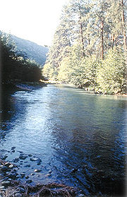
The river has unique hydrological features, such as its color in late summer and early fall and its isolation from other rivers. During the late summer and early fall, glacial outflow from Mount Hood turns the river milky white due to suspended sediment concentrations. It is hydrologically isolated from other river systems, which provides an environment where unique species can evolve.
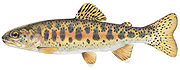
Because of the diverse environments that the White River flows through, as well as its isolation from other rivers, there are a wide variety of life zones within its corridor. Many sensitive and unique plant species are found only in this area, including a genetically unique species of redband trout
Redband trout
Redband trout is a fish name that may be a synonym for the rainbow trout, Oncorhynchus mykiss, but is also used more narrowly for inland subspecies with well-defined geographical distributions in the United States...
.
Recreation
Many fly fishermen
Fly fishing
Fly fishing is an angling method in which an artificial 'fly' is used to catch fish. The fly is cast using a fly rod, reel, and specialized weighted line. Casting a nearly weightless fly or 'lure' requires casting techniques significantly different from other forms of casting...
who fish the lower Deschutes River watch the white river. On hot early summer days the glacial meltoff can cause the Deschutes to become unfishable.