

Capilano River
Encyclopedia
Coast Mountains
The Coast Mountains are a major mountain range, in the Pacific Coast Ranges, of western North America, extending from southwestern Yukon through the Alaska Panhandle and virtually all of the Coast of British Columbia. They are so-named because of their proximity to the sea coast, and are often...
on Vancouver
Vancouver
Vancouver is a coastal seaport city on the mainland of British Columbia, Canada. It is the hub of Greater Vancouver, which, with over 2.3 million residents, is the third most populous metropolitan area in the country,...
's North Shore
North Shore (Greater Vancouver)
"Vancouver's North Shore" is a term commonly used to refer to several areas adjacent to Vancouver, British Columbia, Canada:*the District of West Vancouver;*the City of North Vancouver;*the District of North Vancouver; and...
and empties into Burrard Inlet
Burrard Inlet
Burrard Inlet is a relatively shallow-sided coastal fjord in southwestern British Columbia, Canada. Formed during the last Ice Age, it separates the City of Vancouver and the rest of the low-lying Burrard Peninsula from the slopes of the North Shore Mountains, home to the communities of West...
, opposite Stanley Park
Stanley Park
Stanley Park is a 404.9 hectare urban park bordering downtown Vancouver, British Columbia, Canada. It was opened in 1888 by David Oppenheimer in the name of Lord Stanley of Preston, the Governor-General of Canada....
. The river is one of three primary sources of drinking water for residents of Greater Vancouver
Vancouver
Vancouver is a coastal seaport city on the mainland of British Columbia, Canada. It is the hub of Greater Vancouver, which, with over 2.3 million residents, is the third most populous metropolitan area in the country,...
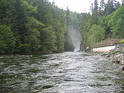
. The Cleveland Dam
Cleveland Dam
The Cleveland Dam is a concrete dam at the head of the Capilano River in North Vancouver, British Columbia, Canada that holds back Capilano Lake. Part of the Capilano River Regional Park, it is not used for generating hydroelectricity, but rather for storing a portion of the Lower Mainland's...
, built in 1954, impounds a reservoir for this purpose. The entire reservoir and watershed area upstream of the dam is closed to the public to ensure the quality of the drinking water.
The Capilano has a historic salmon run
Salmon run
The salmon run is the time at which salmon swim back up the rivers in which they were born to spawn. All Pacific salmon die after spawning. While most Atlantic salmon die after their first spawn, about 5-10% return to the sea to feed between spawnings. The annual run is a major event for sport...
which was impacted by the dam construction. A hatchery
Hatchery
A hatchery is a facility where eggs are hatched under artificial conditions, especially those of fish or poultry. It may be used for ex-situ conservation purposes, i.e. to breed rare or endangered species under controlled conditions; alternatively, it may be for economic reasons A hatchery is a...
was built 1/2 kilometre (km) downstream of the dam to ensure the survival of the run.
The river flows through coastal rainforest and, in its lower stretches, follows a striking granite canyon with walls in excess of 40 metres tall in places.
The Capilano flows during periods of snow melt and rainfall mainly and slows to a trickle at other times.
Route
Capilano River's headwaters are at the top of Capilano Mountain, near Furry Creek. The river then continues down in a valley where many tributaries flow into the river like Eastcap Creek. The river then bends towards its tributary Sister's Creek which has its source at The LionsThe Lions (Peaks)
The Lions are a pair of pointed peaks along the North Shore Mountains in Metro Vancouver, British Columbia, Canada. They can be seen from much of the Greater Vancouver area, as far as Robert Burnaby Park in East Burnaby, south to parts of Surrey, and from the west on the Howe Sound Islands and the...
. Shortly past that confluence, the Capilano River flows into Capilano Lake, created by Cleveland Dam. When the river flows out of the dam it enters Capilano Canyon which it stays for about 4 km. After that it enters into its lowland and enters its mouth at Burrard Inlet, near Ambleside Park.
Recreation

Whitewater
Whitewater is formed in a rapid, when a river's gradient increases enough to disturb its laminar flow and create turbulence, i.e. form a bubbly, or aerated and unstable current; the frothy water appears white...
as class III though at high water it can be much more challenging. A kayaker was killed in high water on the Capilano in 1998.
The Capilano River Regional Park
Capilano River Regional Park
Capilano River Regional Park is located in the District of North Vancouver in British Columbia, Canada. It is one of twenty-one regional parks operated by the Metro Vancouver. The park encompasses most of the upstream areas of the Capilano River below the Cleveland Dam. The area north of the dam...
, which surrounds the river and incorporates the fish hatchery, provides several kilometres of scenic, easy to moderate hiking trails alongside the river.
Every year in March the Capilano River is host to an annual charity duck race. Thousands of yellow rubber ducks are purchased ahead of time by the public. They float down the river in a sea of yellow. The first ducks to reach the mouth of the river win prizes for their owners.