

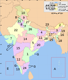
List of districts of India
Encyclopedia
India has 28 States and 7 Union Territories:
There are a total of 640 Districts as per the census of 2011.
The following tables list the population details of various states. The columns include the hierarchical administrative subdivision codes
, the district name, district headquarters, 2001 census population, area in square kilometres, and the population density
per square kilometre. Some districts that are entirely urban (such as Mumbai City) or very small, such as Yanam
in Pondicherry do not have a separate location as district headquarters, and hence are omitted in this table.
mandavra
FA|| Fazilka
|| Fazilka
|| 1,998,464|| 5,021|| 398|| http://fazilka.nic.in/
|}PA|| Pathankot
|| Pathankot
|| 1,998,464|| 5,021|| 398|| http://Pathankot.nic.in/
|}
3|- bgcolor=#F4F9FF
| UT|| Uttarkashi|| Uttarkashi
|| 294,179|| 7,951|| 7||http://uttarkashi.nic.in/
There are a total of 640 Districts as per the census of 2011.
States
EWLINE
|
 |
||||||||||||||||||||||||||||||||||||||||||||||||||||||||||||||||||||||||||||||||||||||||||||||||||||||||||||||||||||||||||||||||||||||
The following tables list the population details of various states. The columns include the hierarchical administrative subdivision codes
Hierarchical administrative subdivision codes
Hierarchical administrative subdivision codes are codes to represent names of country subdivisions, such as states, province, regions.They are described in the book "Administrative Subdivisions of Countries: A Comprehensive World Reference, 1900 Through 1998" written by Gwillim Law.The codes are...
, the district name, district headquarters, 2001 census population, area in square kilometres, and the population density
Population density
Population density is a measurement of population per unit area or unit volume. It is frequently applied to living organisms, and particularly to humans...
per square kilometre. Some districts that are entirely urban (such as Mumbai City) or very small, such as Yanam
Yanam district
Yanam district is one of the four districts of the Union Territory of Pondicherry in India.-Revenue Villages:Apart from the town of Yanam itself, the following villages fall under the district's jurisdiction:* Agraharam* Darialatippa* Farampeta...
in Pondicherry do not have a separate location as district headquarters, and hence are omitted in this table.
Andhra Pradesh (AP)
| Code | District | Headquarters | Population (2001) | Area (km²) | Density (/km²) | Official website |
| AD | Adilabad Adilabad district Adilabad District is a district in Andhra Pradesh, India. The district headquarters is at Adilabad town. A famous Temple of the Goddess Saraswathi, the Hindu Goddess of Education, is located here in the town of Basara.-Origin of name:... |
Adilabad Adilabad Adilabad , is a town and a municipality in Adilabad district in the state of Andhra Pradesh, India. It has a population of 108,233 . It is the headquarters of the district of the same name.-History:... |
2,479,347 | 16,105 | 154 | http://adilabad.nic.in/ |
| AN | Anantapur Anantapur district Anantapur District , ) is one of the 23 districts in Andhra Pradesh, India. The district headquarters is Anantapur City. It is currently a part of the Red Corridor.- Geography :... |
Anantapur | 3,639,304 | 19,130 | 190 | http://anantapur.nic.in/ |
| CH | Chittoor Chittoor district Chittoor District , also known as Chittur, is a district of India's Andhra Pradesh state. The district headquarters is Chittoor City. The district has a population of 4,170,468 according to 2011 census of India. Chittoor district is famous for the Tirupati, Kanipakam and Sri Kalahasti temples... |
Chittoor Chittoor Chittoor also known as Chittur, is a City and municipal corporation located in the Chittoor District of Andhra Pradesh, India. It is conveniently located on major highways linking the cities of Bangalore and Chennai.... |
3,735,202 | 15,152 | 247 | http://chittoor.nic.in/ |
| EG | East Godavari | Kakinada Kakinada Kakinada is a city and a municipal corporation in the Indian state of Andhra Pradesh. It is located east of the state capital, Hyderabad. It is also the headquarters of East Godavari district. It is nicknamed "Fertilizer City" , "Pensioner's Paradise" and "Second Madras"... |
4,872,622 | 10,807 | 451 | http://eastgodavari.nic.in/ |
| GU | Guntur Guntur district Guntur district is located in Andhra Pradesh along the east coast of Bay of Bengal. The district has a coastline of around 100 kilometers. Guntur City is the largest city in the district and administrative center of Guntur District. The district is a major center for learning.-Etymology:There are... |
Guntur Guntur Guntur , is a city and a municipal corporation in the Indian state of Andhra Pradesh, located to the north and west of the Bay of Bengal. It is approximately to the south of the national capital, New Delhi and south east of state capital, Hyderabad. Guntur is the fourth largest city in Andhra... |
4,405,521 | 11,391 | 387 | http://guntur.nic.in/ |
| HY | Hyderabad Hyderabad District, India Hyderabad District , is a district in the state of Andhra Pradesh in India that contains a part of the metropolitan area of Hyderabad. It is headed by a district collector who is drawn from the IAS cadre and is appointed by the state government.-History:... |
Hyderabad | 3,686,460 | 217 | 16,988 | http://hyderabad.nic.in/ |
| CU | YSR district | Kadapa Kadapa Kadapa , formerly Cuddapah, is a city in the south-central part of Andhra Pradesh, India . The city's name originated from the Telugu word "Gadapa" meaning threshold or gate... |
2,573,481 | 15,359 | 168 | http://kadapa.nic.in/ |
| KA | Karimnagar | Karimnagar Karimnagar As of 2011 India census Estimation, Karimnagar city had a population of 2,99,660. Males constitute 51% of the population and females 49% has an average literacy rate of 86.75%, higher than the national average of 74.04%: male literacy is 92.61%, and female literacy is 80.79%. In Karimnagar, 12% of... |
3,477,079 | 11,823 | 294 | http://karimnagar.nic.in/ |
| KH | Khammam Khammam district Khammam District is a district in Andhra Pradesh, India. It had a population of 2,565,412 of which 19.81% were urban as of 2001 census. Khammam town is the district headquarters. The present name of Khammam is derived from the old name Kammamet. Later it was called Khammam Mettu and subsequently... |
Khammam Khammam Khammam , is the headquarters of the Khammam District in Andhra Pradesh state of India and is located about east of state capital, Hyderabad... |
2,565,412 | 16,029 | 160 | http://khammam.nic.in/ |
| KR | Krishna (N T R District) Krishna district Krishna District is a district of India's Andhra Pradesh state. It is named after the Krishna River, the third longest river that flows within India, flows through the district and joins Bay of Bengal here in this district. It has a population of 4,529,009 of which 32.08% is urban as of... |
Machilipatnam Machilipatnam Machilipatnam is a city and a special grade municipality in the Krishna district, Andhra Pradesh, India. It is located south east of state capital, Hyderabad.-History:... |
4,218,416 | 8,727 | 483 | http://krishna.nic.in/ |
| KU | Kurnool Kurnool district Kurnool District is a district in the state of Andhra Pradesh, India, located in the west-central part of the state on the southern banks of the Tungabhadra and Handri rivers. The town of Kurnool is currently the headquarters of the district... |
Kurnool Kurnool Kurnool is located at . It has an average elevation of 273 metres .Kurnool lies on the banks of the Tungabhadra River. The Handry and Neeva rivers also flow through the city. The K.C... |
3,512,266 | 17,658 | 199 | http://kurnool.nic.in/ |
| MA | Mahbubnagar Mahbubnagar district Mahabubnagar or Mahboobnagar , also known as Palamooru is a district in the Andhra Pradesh state of India, in the Telangana region. It is named after its largest city and district headquarters, Mahabubnagar.It is the second largest district in the state in terms of area... |
Mahabubnagar | 3,506,876 | 18,432 | 190 | http://mahabubnagar.nic.in/ |
| ME | Medak Medak district Medak District is located in the state of Andhra Pradesh, India. Sangareddy is the district headquarters of Medak. The district had a population of 2,670,097, of which 14.36% were urban as of 2001... |
Sangareddi Sangareddi Sangareddi or Sangareddy ; earlier known as Sangareddypeta) is the district headquarters of Medak district in the state of Andhra Pradesh in India. It is about 72 km from Medak and 55 km from Hyderabad and is located on Hyderabad-Mumbai Highway . Manjira Wildlife and Bird Sanctuary... |
2,662,296 | 9,699 | 274 | http://medak.nic.in/ |
| NA | Nalgonda Nalgonda district Nalgonda / Nallagonda District is a district in Andhra Pradesh. It has a population of 3,483,648 of which 13.32% is urban as of 2001.-Etymology:Its name is derived from two Telugu words Nalla & Konda i.e... |
Nalgonda Nalgonda Nalgonda is a town and a municipality in Nalgonda district in the Indian state of Andhra Pradesh. Its name is derived from two Telugu words Nalla and Konda . Nalgonda in the past is referred to as Nilagiri. During the period of Bahamani kingdom, it had been renamed as Nallagonda... |
3,238,449 | 14,240 | 227 | http://nalgonda.nic.in/ |
| NE | Nellore Nellore district Sri Amarajeevi Potti Sri Ramulu Nellore District is one of the 23 districts of Andhra Pradesh. Nellore is famous for high paddy field, and so it got its name from "Nelli". The population of the district was 2,966,082 of which 22.45% were urban as of 2011.... |
Nellore Nellore Nellore , is a city and headquarters of Potti Sri Ramulu Nellore District, formerly Nellore district.And in the state of Andhra Pradesh. Ancient name of Nellore was "Vikrama Simhapuri".... |
2,659,661 | 13,076 | 203 | http://nellore.nic.in/ |
| NI | Nizamabad Nizamabad district Nizamabad District is located in the north-western region in the state of Andhra Pradesh, India. It is also known as Induru. Nizamabad is the current and official name of the district.... |
Nizamabad | 2,342,803 | 7,956 | 294 | http://nizamabad.nic.in/ |
| PR | Prakasam Prakasam district Prakasam District is an administrative district in the state of Andhra Pradesh, in India. The district headquarters is located at Ongole City... |
Ongole | 3,054,941 | 17,626 | 173 | http://prakasam.nic.in/ |
| RA | Rangareddi Rangareddi district K. V. Ranga Reddy District is a district in the state of Andhra Pradesh, India. Ranga Reddy District was formed in 1978 when it was split from Hyderabad district. The district has an area of 7,493 km², and a population of 3,575,064 of which 54.20% is urban as of 2001... |
Hyderabad | 3,506,670 | 7,493 | 468 | http://rangareddy.nic.in/ |
| SR | Srikakulam Srikakulam district Srikakulam District , formerly known as Chicacole, is the extreme northeastern District of Andhra Pradesh, situated within the geographic co-ordinates of 18°-20’ and 19°-10’ N and 83°-50’ and 84°-50’ E... |
Srikakulam Srikakulam Srikakulam is a town, municipality and headquarters of Srikakulam district in the north-eastern Andhra Pradesh, India. It is part of Srikakulam Assembly constituency and Srikakulam Parliament Constituency. Srikakulam was formerly called as Gulshanabad during Muslim rule and was headquarter of... |
2,528,491 | 5,837 | 433 | http://srikakulam.nic.in/ |
| VS | Vishakhapatnam Visakhapatnam district Visakhapatnam district , also known as Visakha Zilla, is an administrative division of Andhra Pradesh, India. The administrative headquarters of the Visakhapatnam District is Visakhapatnam.-Post-Independence:... |
Vishakhapatnam | 3,789,823 | 11,161 | 340 | http://visakhapatnam.nic.in/ |
| VZ | Vizianagaram Vizianagaram district Vizianagaram district , also known as Vijayanagaram district is one of the northern coastal districts of Andhra Pradesh, India. Vizianagaram town is the district headquarters... |
Vizianagaram Vizianagaram Vizianagaram is the main city of the Vizianagaram District of north-eastern Andhra Pradesh in southern India. Vizianagaram district was formed on 1 June 1979, with some parts carved from the neighbouring districts of Srikakulam and Visakhapatnam. It is, at present, the largest municipality of... |
2,245,103 | 6,539 | 343 | http://vizianagaram.nic.in/ |
| WA | Warangal Warangal district Warangal District is located in the northern area in the state of Andhra Pradesh, India. The administrative seat is Warangal.Warangal District has an area of 12,846 km², and a population of 3,246,004 of which 19.20% was urban as of 2001... |
Warangal Warangal Warangal is a city and a municipal corporation in Warangal district in the Indian state of Andhra Pradesh. Warangal is located northeast of the state capital of Hyderabad and is the administrative headquarters of Warangal District. This district is a combination of three cities: Warangal,... |
3,231,174 | 12,846 | 252 | http://warangal.nic.in/ |
| WG | West Godavari | Eluru Eluru Eluru is a city and a municipal corporation in the state of Andhra Pradesh, India. It is the headquarters of West Godavari district and has a population of 5,15,343 approximately. Eluru is situated on the national highway NH 5 connecting Vijayawada and Visakhapatnam and about east of state... |
3,796,144 | 7,742 | 490 | http://wgodavari.nic.in/ |
Arunachal Pradesh (AR)
| Code | District | Headquarters | Population (2001) | Area (km²) | Density (/km²) | Official website |
| AJ | Anjaw Anjaw district Anjaw District is an administrative district in the state of Arunachal Pradesh in north-east India. It is a newly created district, having been split from Lohit district on 16 February 2004 under The Arunachal Pradesh Re-organization of Districts Amendment Bill. The district borders China on the... |
Hawai Hawai, India Hawai is the district headquarters of the newly created Anjaw District in the state of Arunachal Pradesh in north-east India. It is located at an altitude of 1296 m above sea level on the banks of the Lohit River, a tributary of the Brahmaputra River.... |
18,428 | 3,234 | 6 | http://lohit.nic.in/ |
| CH | Changlang Changlang District Changlang district is located in the Indian state of Arunachal Pradesh, located south of Lohit district and north of Tirap district. As of 2011 it is the second most populous district of Arunachal Pradesh , after Papum Pare.-Post-independence:... |
Changlang Changlang Changlang is a census town and headquarters of the Changlang district in the Indian state of Arunachal Pradesh. Its native people includes Tangsa Naga, Lisu, Nocte, Singpho and many more.... |
124,994 | 4,662 | 27 | http://changlang.nic.in/ |
| EK | East Kameng | Seppa Seppa Seppa is the headquarters of the East Kameng district in the state of Arunachal Pradesh in India. Sapla means 'marshy' land in the local dialect. It lies on the bank of Kameng River and there is a helipad there. It is located from Itanagar and from Tezpur connected by motorable road... |
57,065 | 4,134 | 14 | http://eastkameng.nic.in/ |
| ES | East Siang | Pasighat Pasighat Pasighat is the headquarters of East Siang district in the Indian state of Arunachal Pradesh. Situated at 155 meters, with its scenic splendours Pasighat is Arunachal's oldest town and also the district headquarters of East Siang.- History:... |
87,430 | 4,005 | 22 | http://eastsiang.nic.in/ |
| EL | Lohit Lohit district Lohit is an administrative district in the state of Arunachal Pradesh in India. The district headquarters are located at Tezu. As of 2011 it is the third most populous district of Arunachal Pradesh , after Papum Pare and Changlang.-Etymology:... |
Tezu Tezu Tezu is a census town and the headquarters of Lohit district in the Indian state of Arunachal Pradesh.The ancient inhabitant of this land of valley and rivers are the Mishmi tribes. The Mishmi tribes have traditions and customs dating back to the times of Mahabharata. According to sacred Hindu... |
143,478 | 2,402 | 13 | http://lohit.nic.in/ |
| LB | Lower Subansiri | Ziro Ziro Ziro is a census town in Lower Subansiri district in the Indian state of Arunachal Pradesh.-Geography:Ziro is the district headquarter of Lower Subansiri district and is one of the oldest towns in Arunachal Pradesh. It was the headquarters of the undivided Subansiri district comprising the present... |
97,614 | 10,135 | 10 | http://lowersubansiri.nic.in/ |
| PA | Papum Pare Papum Pare district Papum Pare district is an administrative district in the state of Arunachal Pradesh in India. As of 2011 it is the most populous district of Arunachal Pradesh.-Geography:... |
Yupia Yupia Yupia is the headquarters of Papum Pare district in the state of Arunachal Pradesh in India. Yupia is about 20 km from Itanagar, the state capital.... |
167,750 | 2,875 | 42 | http://papumpare.nic.in/ |
| TA | Tawang Tawang District Tawang district is one of the 16 administrative districts of Arunachal Pradesh in eastern India. The area is historically Tibetan territory and is claimed by both India and Republic of China as a part of South Tibet... |
Tawang Town Tawang Town Tawang is a small town situated at an elevation of approximately 3,048 meters in the northwestern part of Arunachal Pradesh state of India. The area is historically Tibetan territory and is claimed by both People's Republic of China and Republic of China as a part of South Tibet... |
38,924 | 2,085 | 19 | http://tawang.nic.in/ |
| TI | Tirap Tirap district The Tirap district is located in the southeastern part of the state of Arunachal Pradesh in India. It shares a state border with Nagaland and Assam, an international border with Myanmar and a district border with Changlang.- History :... |
Khonsa Khonsa Khonsa is the headquarters of Tirap district in the Indian state of Arunachal Pradesh. It also houses one of the State viz., Ramakrishna Sarada Mission School. The town is cosmopolitan in nature as people from every Indian State could be found here.... |
100,227 | 2,362 | 42 | http://tirap.nic.in/ |
| UD | Dibang Valley | Anini Anini Anini is the headquarters of the Dibang Valley district in the state of Arunachal Pradesh in Northeast India. Anini was also the district headquarters of the undivided Dibang Valley district. It is a small underdeveloped town, mainly because of its remoteness. Yet, it still has basic road and air... |
257,543 | 23,029 | 4 | http://dibang.nic.in/ |
| US | Upper Siang Upper Siang district Upper Siang is an administrative district in the state of Arunachal Pradesh in India. It is the fourth least populous district in the country .- History :At one point of history this place was part of Independent Tibet and known as Pemako... |
Yingkiong Yingkiong Yingkiong is the headquarters of Upper Siang district in the state of Arunachal Pradesh in India.-External links:*... |
33,146 | 6,188 | 5 | http://uppersiang.nic.in/ |
| UB | Upper Subansiri | Daporijo Daporijo Daporijo is a census town in the Indian state of Arunachal Pradesh. It is the headquarters of Upper Subansiri district. Daporijo is located at an elevation of 600 m above sea level.-Demographics:... |
54,995 | 7,032 | 8 | http://uppersubansiri.nic.in/ |
| WK | West Kameng | Bomdila Bomdila Bomdila is the headquarters of West Kameng district in the state of Arunachal Pradesh in India.-Geography:Bomdila is located at . It has an average elevation of 2217 metres .-Demographics:... |
74,595 | 7,422 | 10 | http://westkameng.nic.in/ |
| WS | West Siang | Along | 103,575 | 8,325 | 12 | http://westsiang.nic.in/ |
Assam (AS)
| Code | District | Headquarters | Population (2001) | Population (2011) | Area (km²) | Density (/km²) | Official website |
| BA | Barpeta Barpeta District Barpeta district is an administrative district in the state of Assam in India. The district headquarters are located at Barpeta. The district occupies an area of 3245 km² and has a population of 1,642,420 .-History:... |
Barpeta Barpeta Barpeta is the headquarters of Barpeta district, Assam, India. The city is located about north west of Guwahati.Barpeta is renowned in the Historical map of Assam as the "Land of the Satras"... |
1,642,420 | 3,245 | 506 | http://barpeta.gov.in/ | |
| BO | Bongaigaon | Bongaigaon Bongaigaon Bongaigaon is the district headquarters of Bongaigaon District, Assam, India. The city is situated north west of Guwahati.It is a very developing City in Lower Assam. It has two parts - Old Bongaigaon and New Bongaigaon. Bongaigaon is predominantly inhabited by the Koch Rajbongshi Community which... |
906,315 | 2,510 | 361 | http://bongaigaon.gov.in/ | |
| CA | Cachar Cachar District Cachar is an administrative district in the state of Assam in India.-Etymology:The name "Cachar" has derived from the words 'kacha' & 'har'.The district headquarters are located at Silchar... |
Silchar Silchar Silchar is the headquarters of Cachar district in the state of Assam in India. It is the economic gateway to the state of Mizoram and part of Manipur. It is south east of Guwahati. The city of Silchar has tremendous commercial importance and is the second largest city in the state of Assam... |
1,442,141 | 3,786 | 381 | http://cachar.gov.in/ | |
| DA | Darrang Darrang District Darrang is an administrative district in the state of Assam in India. The district headquarters are located at Mangaldai. The district occupies an area of 3481 km².-History:In 1983 Sonitpur district was formed from part of Darrang... |
Mangaldai | 1,503,943 | 3,481 | 432 | http://darrang.gov.in/ | |
| DM | Dhemaji Dhemaji District Dhemaji district is an administrative district in the state of Assam in India. The district headquarters are located at Dhemaji. The district occupies an area of 3237 km² and has a population of 571,944... |
Dhemaji Dhemaji Dhemaji is the headquarters of Dhemaji district, Assam, India. It is one of the remotest districts of Assam. From the State Capital , it takes about 10 hours by road to reach Dhemaji. Dhemaji is a very flood-prone district. For a few days it remains cut off from the rest of the country every year... |
569,468 | 3,237 | 176 | http://dhemaji.gov.in/ | |
| DB | Dhubri Dhubri District Dhubri District is an administrative district in the state of Assam in India. The district headquarters are located at Dhubri town which is situated at ~290 km from Guwahati, the state capital. This was also the headquarters of erstwhile Goalpara district which was created in 1876 by the... |
Dhubri Dhubri Dhubri is the headquarters of Dhubri district India. It is a small old town on the bank of the Brahmaputra and Gadadhar Rivers. In 1883, the town was first constituted as a Municipal Board and is situated about west from Guwahati, the state capital.Dhubri was an important commercial centre and... |
1,634,589 | 2,838 | 576 | http://dhubri.gov.in/ | |
| DI | Dibrugarh Dibrugarh district Dibrugarh is an administrative district in the state of Assam in India. The district headquarters are located at Dibrugarh city. The district occupies an area of 3381 km².-Etymology:... |
Dibrugarh Dibrugarh Dibrugarh is the headquarters of Dibrugarh district, Assam, India, and is the second largest city in Assam after Guwahati. It is situated on the banks of the Brahmaputra River, about north-east of Guwahati. It is the gateway to the three tea-producing districts of Tinsukia, Dibrugarh, and Sibsagar... |
1,172,056 | 3,381 | 347 | http://dibrugarh.gov.in/ | |
| GP | Goalpara Goalpara District Goalpara district is an administrative district in the state of Assam in India. The district headquarters are located in Goalpara town.-History:... |
Goalpara Goalpara Goalpara is the district headquarter of Goalpara district, Assam, India. It is situated west of Guwahati.-Etymology:The name of Goalpara is said to have originally derived from `Gwaltippika` meaning `Guwali village` or the village of the milk men. In the local dialect "para" means... |
822,306 | 1,824 | 451 | http://goalpara.gov.in/ | |
| GG | Golaghat Golaghat District Golaghat district is an administrative district in the state of Assam in India. It attained district status in 1987. The district headquarters are located at Golaghat. The district occupies an area of 3502 km² and lies 100 m above sea level. As of 2001, Golaghat district has a population of... |
Golaghat Golaghat Golaghat , which was one of the largest subdivisions of Assam later, elevated to the position of a full-fledged district of Assam on 15 August 1987, is the headquarters of Golaghat district and is a sister town to Jorhat which is about 55 km away.... |
945,781 | 3,502 | 270 | http://golaghat.gov.in/ | |
| HA | Hailakandi Hailakandi district Hailakandi district was one of the 27 districts of Assam state in north-eastern India. It was constituted as a civil subdivision on 1 June 1869. Subsequently, it was upgraded to district in 1989, when it was split from Cachar district... |
Hailakandi Hailakandi Hailakandiis a town and a district in Hailakandi district in the Indian state of Assam.The Hailakandi district is one of the three districts of Southern Assam i.e. Barak Valley.-Geography:... |
542,978 | 1,327 | 409 | http://hailakandi.nic.in/ | |
| JO | Jorhat Jorhat district Jorhat district is one of the twenty-seven districts of Assam state in north-eastern India. Jorhat town is the district headquarters.-History:... |
Jorhat Jorhat Jorhat is a city of Assam in India. Jorhat was established as a new capital in the closing years of the 18th century by the declining Tunkhungia Ahom Dynasty. Jorhat, as the name signifies, was just a couple of markets . Two parallel markets namely, Chowkihat and Macharhat, lay on the eastern... |
1,009,197 | 2,851 | 354 | http://jorhat.gov.in/ | |
| KA | Karbi Anglong Karbi Anglong District Karbi Anglong district is the largest amongst the 27 administrative districts of Assam state in north-eastern India. The district is bounded by Golaghat district on the east, Meghalaya state and Marigaon district on the west, Nagaon and Golaghat districts on the north and Dima Hasao district and... |
Diphu Diphu Diphu is the headquarters of Karbi Anglong district in the state of Assam in India.-Geography:Diphu is located at . It has an average elevation of 186 metres . It is about 270 km by road and 213 km by railways from Guwahati, State capital of Assam.-Demographics: India census, Diphu... |
812,320 | 10,434 | 78 | http://karbianglong.gov.in/ | |
| KR | Karimganj Karimganj district Karimganj District is an administrative district in the state of Assam in India. The district headquarters are located at Karimganj.-Early period:... |
Karimganj Karimganj Karimganj Town is a town in the Karimganj District of the Indian state of Assam. It is the administrative headquarter and main town of the district.-Geography:... |
1,003,678 | 1,809 | 555 | http://karimganj.gov.in/ | |
| KK | Kokrajhar Kokrajhar district Kokrajhar district is an administrative district in the state of Assam in north-eastern India. The district headquarters are located at Kokrajhar town. The district occupies an area of 3,169.22 km². , the district had a population of 905,764. Hindus 594,168, Muslims 184,441.-History:Kokrajhar... |
Kokrajhar Kokrajhar Kokrajhar is a city in Bodoland Territorial Council, Assam, one of the North East States and territories of India.Kokrajhar city is located along the bank of Gourang River. The North East Indian Railways divides the city into two sides, north and the south... |
930,404 | 3,129 | 297 | http://kokrajhar.gov.in/ | |
| LA | Lakhimpur Lakhimpur district Lakhimpur is an administrative district in the state of Assam in India. The district headquarters are located at North Lakhimpur.- History :... |
Lakhimpur | 889,325 | 2,277 | 391 | http://lakhimpur.gov.in/ | |
| MA | Marigaon Marigaon district Marigaon district is an administrative district in the state of Assam in India. The district headquarters are located at Marigaon. The district occupies an area of 1,550 km² and has a population of 957,853 of which males and females are 485,328 and 472,525 respectively.The ancient place of... |
Marigaon Marigaon Marigaon is a town of town area committee and the district headquarter of Marigaon district in the Indian state of Assam.-Demographics: India census, Marigaon had a population of 20,807. Males constitute 52% of the population and females 48%. Marigaon has an average literacy rate of 76%, higher... |
775,874 | 1,704 | 455 | http://morigaon.nic.in/ | |
| NG | Nagaon Nagaon district Nagaon is an administrative district in the state of Assam in India. As of 2011 it is the most populous district of Assam .-History:... |
Nagaon Nagaon Nagaon , is a medium sized city and a municipal board in Nagaon district in the Indian state of Assam. It is situated east of Guwahati. An older spelling of the name is Nowgong.It is one of the fastest growing cities of the northeast.-History:... |
2,315,387 | 3,831 | 604 | http://nagaon.gov.in/ | |
| NL | Nalbari Nalbari district Nalbari is an administrative district in the state of Assam in India. The district headquarters are located at Nalbari.-History:The district was created on 14 August 1985 when it was split from Kamrup district... |
Nalbari Nalbari Nalbari is a city and a municipal board in Nalbari district in the Indian state of Assam. Nalbari is headquarter of Nalbari District.-Education:... |
1,138,184 | 2,257 | 504 | http://nalbari.nic.in/ | |
| NC | Dima Hasao | Haflong Haflong Haflong is a town and headquarters of Dima Hasao District [Formerly Known as North Cachar Hills] district in India in the state of Assam.It is adoringly called the 'Switzerland of the East'. Haflong is a quaint hill station breath takingly beautiful,garlanded by the hills and an unending saga... |
186,189 | 4,888 | 38 | http://nchills.gov.in/ | |
| SI | Sibsagar Sibsagar district Sibsagar district -- also known as Sivasagar -- is one of the 27 districts of Assam state in north-eastern India. Sibsagar city is the administrative headquarters of this district.-History:... |
Sibsagar Sibsagar Sivasagar is a town in the Sibsagar district in the state of Assam in India, about north east of Guwahati.... |
1,052,802 | 2,668 | 395 | http://sivasagar.nic.in | |
| SO | Sonitpur | Tezpur Tezpur Tezpur is a city and the administrative headquarters and municipal board of Sonitpur district in the state of Assam in northeastern India. Tezpur is an ancient city on the banks of the river Brahmaputra and is the largest of the north bank towns with a population exceeding 100,000... |
1,677,874 | 5,324 | 315 | http://sonitpur.gov.in/ | |
| TI | Tinsukia Tinsukia district Tinsukia district is one of the 27 administrative districts in the state of Assam, India. The district headquarters are located at Tinsukia. Tinsukia district occupies an area of , comparatively equivalent to South Georgia.- History :... |
Tinsukia Tinsukia Tinsukia is a city and a municipal board in Tinsukia district, Assam, India.Tinsukia is a business city in the Indian state of Assam. It is situated north east of Guwahati and kilometres away from the border with Arunachal Pradesh. It is the administrative headquarters of Tinsukia District of... |
1,150,146 | 3,790 | 303 | http://tinsukia.gov.in/ |
Bihar (BR)
| Code | District | Headquarters | Population (2011) | Area (km²) | Density(2011) (/km²) | Official website |
| AR | Araria Araria District Araria district is one of the thirty-eight districts of Bihar state, India, and Araria town is the administrative headquarters of this district. Araria district is a part of Purnia division. The district occupies an area of 2830 km².-Origin of name:... |
Araria Araria Araria is a town and a municipality that is headquarters of Araria district in the state of Bihar, India.-Geography:Araria is located at . It has an average elevation of 47 metres . Araria is situated at the northern part of Purnia and Madhepura in Bihar... |
2,806,200 | 2,829 | 992 | http://araria.bih.nic.in |
| Arwal Arwal District Arwal district is one of the thirty-eight districts of Bihar state, India, and Arwal town is the administrative headquarters of this district. It was earlier part of Jehanabad district.... |
Arwal Arwal Arwal is the administrative headquarters of Arwal district in the Indian state of Bihar.-Geography:Arwal is located at . It has an average elevation of . The district headquarters is at the bank of Sone river. The state capital, patna is 65 km to the north... |
699,563 | 4,839 | 1099 | http://arwal.bih.nic.in/ | |
| AU | Aurangabad Aurangabad District, Bihar Aurangabad district is one of the thirty-eight districts of Bihar state, India. It is currently a part of the Red Corridor.-History:Aurangabad features in traditional records... |
Aurangabad Aurangabad, Bihar Aurangabad is a city and a municipality in Aurangabad district in the state of Bihar, India. Aurangabad is the district headquarters of the Aurangabad district. It is situated on the Grand Trunk Road. The people of this region primarily speak Magahi. Due to lack of industrialization, people are... |
2,511,243 | 3,303 | 760 | http://aurangabad.bih.nic.in |
| BA | Banka Banka District Banka is one of the thirty-eight districts of Bihar in India.-History:Banka is the homeland of great revolutionary Satish Prasad Jha, one of seven martyrs who hoisted the flag of India at the Secretariat building near Patna on 11 August 1942. Jha was born in Khadihara near Dhakamod, Banka... |
Banka Banka, Bihar Banka is a city and a municipality in Banka district in the state of Bihar, India. The Hindi meaning of Banka is brave. Banka is one of the thirty-eight districts of Bihar in India. The district, part of Bhagalpur Division, has its headquarters at Banka town. The district occupies an area of... |
2,029,339 | 3,018 | 672 | http://banka.bih.nic.in |
| BE | Begusarai Begusarai District Begusarai District is one of the thirty-eight districts of Bihar state, India, and Begusarai town is the administrative headquarters of this district.-Etymology:The name of the district apparently comes from "Begum" + "Sarai"... |
Begusarai Begusarai Begusarai is a city and a municipal council in Begusarai district in the state of Bihar, India. Begusarai had traditionally been a communist stronghold and it was earlier also referred to as the Leningrad of Bihar.- Recent history :... |
2,954,367 | 1,917 | 1,540 | http://begusarai.bih.nic.in |
| BG | Bhagalpur Bhagalpur District Bhagalpur district is one of the thirty-eight districts of Bihar state, India, and Bhagalpur town is the administrative headquarters of this district.-Geography:... |
Bhagalpur Bhagalpur Bhagdattpuram was one of the most influential towns in "Aryavarta" . It is supposed to have been concurrent to Patliputra or Patna. Bhagdattpuram finds its mention in the Vedas and Ramayana as well. It is supposed to be the kingdom of Daanvir Karna, the son of Kunti and the Sun God... |
3,032,226 | 2,569 | 1,180 | http://bhagalpur.bih.nic.in |
| BJ | Bhojpur Bhojpur district, Bihar Bhojpur district is one of the thirty-eight districts of Bihar state in eastern India. Arrah town is the administrative headquarters of this district.-History:... |
Arrah Arrah Arrah is a city and a municipal corporation in Bhojpur district in the state of Bihar, India. The actual name of Arrah is Ara but it was misspelt by the British and now corrected to Ara but still known as Arrah in many records. It is the district headquarters of Bhojpur district, located near the... |
2,720,155 | 2,473 | 1,136 | http://bhojpur.bih.nic.in |
| BU | Buxar | Buxar Buxar Buxar district is one of the thirty-eight districts of Bihar state, India. The district headquarters are located at Buxar.-Mythology:This place was also known as "Siddhashram", "Vedgarbhapuri", "Karush", "Tapovan", "Chaitrath", "VyaghraSar", "Buxar" in ancient history. The History of Buxar dates... |
1,707,643 | 1,624 | 1,003 | http://buxar.bih.nic.in |
| DA | Darbhanga Darbhanga District Darbhanga district is one of the thirty-eight districts of Bihar state in eastern India, and Darbhanga town is the administrative headquarters of this district. Darbhanga district is a part of Darbhanga Division... |
Darbhanga Darbhanga Darbhangā is a twin city and a municipal corporation and the capital city of the Darbhanga district and Darbhanga Division in the state of Bihar, India. It is one of the most important districts of North Bihar situated in the very heart of Mithilanchal. According to the latest 2011 census, the... |
3,921,971 | 2,278 | 1,721 | http://darbhanga.bih.nic.in |
| EC | East Champaran | Motihari Motihari Motihari is the headquarters of East Champaran district in the Indian state of Bihar.-History:In 1866 Champaran was made into a district with Motihari as its headquarters. On 1 December 1977 the Champaran district was divided into two districts, and Motihari became the headquarters of East... |
5,082,868 | 3,969 | 1281 | http://eastchamparan.bih.nic.in |
| GA | Gaya Gaya District Gaya is one of the thirty-eight districts of Bihar state, India. The district is having a common boundary with the Jharkhand state in the south. Gaya city is its largest city and the district headquarters.-History:... |
Gaya Gaya, India Gaya is the second largest city of Bihar, India, and it is also the headquarters of Gaya District.Gaya is 100 kilometers south of Patna, the capital city of Bihar. Situated on the banks of Falgu River , it is a place sanctified by both the Hindu and the Buddhist religions... |
4,379,383 | 4,978 | 880 | http://gaya.bih.nic.in |
| GO | Gopalganj Gopalganj District, India Gopalganj is the administrative district in the state of Bihar in India. The district headquarter is located in the town of Gopalganj and the district is a part of Saran Division. Languages spoken are Bhojpuri, Urdu and Hindi.-History:... |
Gopalganj Gopalganj, India Gopalganj is a town, municipality and the headquarter of Gopalganj district in the Indian state of Bihar which got independence from the old Saran district on October 2, 1973.-Geography:... |
2,558,037 | 2,033 | 1,258 | http://gopalganj.bih.nic.in |
| JA | Jamui Jamui District Jamui is one of the thirty-eight districts of Bihar state, India. The district was formed as a District on 21 February 1991 as a result of its separation from Munger district. It is located at a longitude of 86º-13'E and the latitude is 24º-55'N.... |
Jamui Jamui Jamui is a city and a municipality in Jamui district in the Indian state of Bihar. It is the district headquarters of Jamui district.-Geography:Jamui is located at... |
1,756,078 | 3,099 | 567 | http://jamui.bih.nic.in |
| JE | Jehanabad Jehanabad District Jehanabad district is one of the thirty-eight districts of Bihar state, India, and Jehanabad town is the administrative headquarters of this district. Jehanabad district is a part of Magadh Division. This district is 45 k.m nearby of Patna, the capital of Bihar.Jehanabad is located on the... |
Jehanabad Jehanabad Jehanabad is a city and a municipality in and the headquarters of Jehanabad district in the Indian state of Bihar. Earlier, Jehanabad was part of Gaya district. It is 50 km away from both Patna and Gaya.-Demographics:... |
1,124,176 | 1,569 | 1206 | http://Jehanabad.bih.nic.in |
| KH | Khagaria Khagaria District Khagaria district is an administrative district in the state of Bihar in India. The district headquarters are located at Khagaria. Khagaria district is a part of Munger Division.... |
Khagaria Khagaria Khagaria is a city in India, and the administrative headquarter of Khagaria district. Khagaria is a part of Munger division. The town has a major railway junction on the Barauni Guwahati section of the Indian Railways. National Highway 31 which connects rest of the India to North Eastern region... |
1,657,599 | 1,486 | 1,115 | http://khagaria.bih.nic.in |
| KI | Kishanganj Kishanganj District Kishanganj district is one of the thirty-eight districts of Bihar state, India, and Kishanganj town is the administrative headquarters of this district. Kishanganj district is a part of Purnia division.-History:... |
Kishanganj Kishanganj Kishanganj is headquarters of Kishanganj district in the Indian state of Bihar.-Geography:Kishanganj is a town and district headquarter of Kishangnj district in Purnea division of Bihar state, but gographically and culturally it is part of the north Bengal.It is part of the chicken neck of Indian... |
1,690,948 | 1,884 | 898 | http://kishanganj.bih.nic.in |
| KM | Kaimur Kaimur District Kaimur district is one of the thirty-eight districts of Bihar state, India. The district headquarters are located at Bhabua. The district occupies an area of 3363 km² and has a population of 1,284,575 .... |
Bhabua Bhabua Bhabua is a city and a municipality in Kaimur district in the state of Bihar, India. It is the headquarters of Kaimur district in the state of Bihar, in India.- Geography :... |
1,626,900 | 3,363 | 488 | http://kaimur.bih.nic.in |
| KT | Katihar Katihar District Katihar district is one of the thirty-seven districts of Bihar state, India, and Katihar town is the administrative headquarters of this district... |
Katihar Katihar Katihar is a town situated in the north eastern part of Bihar state in India. It is headquarters of Katihar district.- Geography :Katihar is located at... |
3,068,149 | 3,056 | 1004 | http://katihar.bih.nic.in |
| LA | Lakhisarai Lakhisarai District Lakhisarai district is one of the thirty-eight districts of Bihar state, India, and Lakhisarai town is the administrative headquarters of this district. Lakhisarai district is a part of Munger Division. The district occupies an area of 1228 km2... |
Lakhisarai Lakhisarai Lakhisarai town is the administrative headquarters of Lakhisarai district in Bihar state in eastern India. The town has a population of 77,840 . It is well connected by road and rail routes. It is situated on Patna-Howrah main line passing through Kiul junction. NH-80 passes through the town... |
1,000,717 | 1,229 | 815 | http://lakhisarai.bih.nic.in |
| MB | Madhubani Madhubani District Madhubani District is one of the thirty-eight districts of Bihar state, India, and Madhubani town is the administrative headquarters of this district. Madhubani district is a part of Darbhanga Division. The district occupies an area of 3501 km² and has a population of 3,570,651... |
Madhubani | 4,476,044 | 3,501 | 1,279 | http://madhubani.bih.nic.in |
| MG | Munger Munger District Munger district is one of the thirty-eight districts of Bihar state in eastern India. Munger town is the administrative headquarters of this district. Munger district is a part of Munger Division. Its literacy rate of 73.3% is higher than the state literacy rate of 63.8% and lower than national... |
Munger Munger Munger town is the headquarters of Munger district, in the Indian state of Bihar. Historically, Munger is known for its manufacturing of iron articles such as firearms and swords. One of the major institutions in Munger is Bihar School of Yoga. It is one of the foremost learning center in the... |
1,359,054 | 1,419 | 958 | http://munger.bih.nic.in |
| MP | Madhepura Madhepura District Madhepura district is one of the thirty-eight districts of Bihar state, India, and Madhepura town is the administrative headquarters of this district. Madhepura district is a part of Kosi division.-History:... |
Madhepura Madhepura Madhepura is a city and a municipality in Madhepura district in the Indian state of Bihar. Madhepura as it stands now was carved out of Saharsa district and got the status of revenue district on 9 May 1981. Prior to that, Madhepura was a sub-division under Bhagalpur district with effect from 3... |
1,994,618 | 1,787 | 1116 | http://madhepura.bih.nic.in |
| MZ | Muzaffarpur Muzaffarpur District Muzaffarpur District is one of the thirty-eight districts of Bihar state, India, and Muzaffarpur town is the administrative headquarters of this district. Muzaffarpur district is a part of Tirhut Division.... |
Muzaffarpur Muzaffarpur Muzaffarpur Town is a town in Muzaffarpur district in the Indian state of Bihar. It serves as the headquarters of Muzaffarpur district and Tirhut division.... |
4,778,610 | 3,173 | 1,506 | http://muzaffarpur.bih.nic.in |
| NL | Nalanda Nalanda District Nalanda district is one of the thirty-eight districts of Bihar state, India, and Bihar Sharif town is the administrative headquarters of this district... |
Bihar Sharif Bihar Sharif Bihar Sri is the district headquarters of Nalanda district in the state of Bihar in eastern India.-History:The ancient Odantpuri University was located here, an important centre for the learning of Buddhism. Odatpuri is center of Buddhist culture... |
2,872,523 | 2,354 | 1,220 | http://nalanda.bih.nic.in |
| NW | Nawada Nawada District Nawada district is one of the thirty-eight districts of Bihar state, India, and Nawada town is the administrative headquarters of this district. The district was part of famous Magadh, Sunga and Gupta empires. It is located between historical districts of Nalanda and Gaya and falls under Magadha... |
Nawada Nawada Nawada is a city and a municipality. It is also the headquarters of Nawada district in the Indian state of Bihar.-Geography:Nawada is located at . It has an average elevation of 80 metres... |
2,216,653 | 2,492 | 889 | http://nawada.bih.nic.in |
| PA | Patna Patna District Patna district is one of the thirty-eight districts of Bihar state, with Patna as the district headquarters. Patna district is a part of Patna division... |
Patna Patna Paṭnā , is the capital of the Indian state of Bihar and the second largest city in Eastern India . Patna is one of the oldest continuously inhabited places in the world... |
5,772,804 | 3,202 | 1,803 | http://patna.bih.nic.in |
| PU | Purnia Purnia District Purnia district is one of the thirty-eight districts of Bihar state, India. The town of Purnia is the administrative headquarters of this district.Purnia district is a part of Purnia Division... |
Purnia Purnia Purnia is a city and a Municipal Corporation in Purnia district of the Indian state of Bihar. It is located 400 km from Patna.The Indian army, Border Security Force ,and the SSB and the have bases around the city... |
3,273,127 | 3,228 | 1014 | http://purnia.bih.nic.in |
| RO | Rohtas Rohtas district Rohtas district is one of the thirty-eight districts of Bihar state, India.The Rohtas district is a part of Patna Division, and it has an area of 3850 km² , a population of 2,448,762 , and a population density of 636 persons per km²... |
Sasaram Sasaram Sasaram , sometimes also spelled as Sahasram, is the administrative headquarters of the Rohtas district in the Indian state of Bihar.It is one of the oldest cities in India, and is famous for production of stone chips and for the local quarrying industry... |
2,962,593 | 3,850 | 763 | http://rohtas.bih.nic.in |
| SH | Saharsa Saharsa District Saharsa is one of the thirty-eight districts of Bihar, India. Saharsa town is the administrative headquarters of this district. Saharsa district is a part of a larger territory, the Kosi Division and it became a district on 1 April 1954 and subsequently has become smaller with other districts being... |
Saharsa Saharsa Saharsa is a city and a municipality in the Saharsa district in the Indian state of Bihar in north India, east of the Kosi River. It is the administrative headquarters of the Saharsa District, and is in the Kosi Division. Sahrasa is also the name of the Parliamentary constituency, which contains... |
1,897,102 | 1,702 | 1125 | http://saharsa.bih.nic.in |
| SM | Samastipur Samastipur District Samastipur is one of the thirty-eight districts of Bihar in India. The district headquarters are located at Samastipur. The district occupies an area of 2904 km² and has a population of 27,16,929 .- History :... |
Samastipur Samastipur Samastipur is a city and a municipality in Samastipur district in the Indian state of Bihar. It is headquarters of the Samastipur district.It is situated on the banks of Burhi Gandak River.-Demographics:... |
4,254,782 | 2,905 | 1,465 | http://samastipur.bih.nic.in |
| SO | Sheohar Sheohar District Sheohar is an administrative district in the state of Bihar in India. The district headquarters are located at Sheohar, and the district is a part of Tirhut Division. This district was carved out of Sitamarhi district in 1994... |
Sheohar Sheohar Sheohar is headquarters of Sheohar district.-Geography:Sheohar is located at coor 26.52N, 85.3E. It has an average elevation of 53 metres .The district contains five blocks: Piprahi, Purnahiya, Sheohar, Taryani and Dumri Katsari.... |
656,916 | 443 | 1,882 | http://sheohar.bih.nic.in |
| SP | Sheikhpura Sheikhpura District Sheikhpura district is one of the thirty eight districts of Bihar state, India, and Sheikhpura town is the administrative headquarters of this district. Sheikhpura district is a part of Munger Division... |
Sheikhpura Sheikhpura Sheikhpura is a city and a municipality in Sheikhpura district in the Indian state of Bihar. Sheikhpura is also an administrative district in the state of Bihar in India. The district occupies an area of 689 km² and has a population of 5,25,502 . Sheikhpura has given the leaders like Shri... |
634,927 | 689 | 922 | http://sheikhpura.bih.nic.in |
| SR | Saran Saran district Saran District is one of the thirty-seven districts of Bihar state, India. The district, part of Saran Division, is also known as Chapra district after the headquarters of the district - Chapra... |
Chhapra Chhapra Chhapra is a city and headquarters of Saran district in the state of Bihar, India. Chhapra is also written as Chapra. It is situated near the junction of the Ghaghara River and The Ganges River.... |
3,943,098 | 2,641 | 1,493 | http://saran.bih.nic.in |
| ST | Sitamarhi Sitamarhi District Sitamarhi is one of the districts of Bihar state, India, and Sitamarhi town is the administrative headquarters of this district. Sitamarhi district is a part of Tirhut Division.- History :... |
Sitamarhi Sitamarhi Sitamarhi is a town and the district headquarters of Sitamarhi district, Bihar, India.-History:The name Sitamarhi, derives from "Sitamahi", meaning "hermitage of Sita". It is the mythological birthplace of Sita, and the spiritual centre of many sages and saints.This district is often bereaved by... |
3,419,622 | 2,199 | 1,491 | http://sitamarhi.bih.nic.in |
| SU | Supaul Supaul District Supaul district is one of the thirty-eight districts of Bihar state, India, and Supaul town is the administrative headquarters of this district. This district occupies an area of... |
Supaul Supaul Supaul is a town and a municipality that is headquarters of Supaul district in the Indian state of Bihar. Not far from this place is the Indian border connecting Nepal. The Supaul Town is the administrative headquarters of this district.... |
2,228,397 | 2,410 | 919 | http://supaul.bih.nic.in |
| SW | Siwan Siwan District Siwan district is one of the districts of Bihar state, India. Siwan town is the administrative headquarters of this district. Siwan district is a part of Saran Division since 1972. The town is known for its great past especially for First President of Indian Republic who belonged to Jeeradei. The... |
Siwan Siwan, Bihar Siwan is the district headquarters of the Siwan district in the Indian state of Bihar.Ziradei village in Siwan district is the birth place of Dr. Rajendra Prasad, the first President of Republic of India. Mr. Sant Kumar Verma was the Personal Assistant of Dr... |
3,318,176 | 2,219 | 1,495 | http://siwan.bih.nic.in |
| VA | Vaishali Vaishali District Vaishali District is a district in Bihar state, India. It is named after the Vaishali . The history of Vaishali district is thus very ancient, and finds mention in the Indian classic Mahabharata, as well as in Buddhist and Jain tradition.... |
Hajipur Hajipur Hajipur is the headquarters of Vaishali district in the Indian state of Bihar. It is famous for producing bananas, and has a modern railway zonal office. Patna, the capital of Bihar is only 10 km from Hajipur... |
3,495,249 | 2,036 | 1,717 | http://vaishali.bih.nic.in |
| WC | West Champaran | Bettiah Bettiah Bettiah is the headquarters of West Champaran district in the state of Bihar, near the Indo-Nepal border, 225 Kilometres north-west of Patna. Bettiah, pronounced as 'Betiya', derived its name from 'baint'... |
3,922,780 | 5,229 | 750 | http://westchamparan.bih.nic.in |
Chhattisgarh (CT)
| Code | District | Headquarters | Population (2001) | Area (km²) | Density (/km²) | Official website |
| BA | Bastar Bastar District Bastar District is a district of the state of Chhattisgarh in central India. Jagdalpur is the district headquarters. The district has an area of 8755.79 km²... |
Jagdalpur Jagdalpur Jagdalpur is a city and a municipality in Bastar district in the Indian state of Chhattisgarh. It is the administrative headquarters of Bastar District and Bastar Division, and was the capital of the erstwhile princely state of Bastar. Jagdalpur and its surrounding area comprise a major part of the... |
1,302,253 | 14,968 | 87 | http://bastar.nic.in/ |
| Bijapur Bijapur district, Chhattisgarh Bijapur district is one of the 18 districts of Chhattisgarh state in central India. It is one of the two new districts created on May 11, 2007. As of 2011 it is the second least populous district of Chhattisgarh , after Narayanpur... |
Bijapur | 229,832 | 6,555 | 35 | ||
| BI | Bilaspur Bilaspur District, Chhattisgarh Bilaspur district is a district of the Chhattisgarh state of India. Bilaspur city is the headquarters of the district. As of 2011 it is the third most populous district of Chhattisgarh , after Raipur and Durg.- Etymology :... |
Bilaspur Bilaspur, Chhattisgarh Bilaspur is a city in Bilaspur District in the Indian state of Chhattisgarh, situated 111 km north of state capital, Raipur. It is the second-largest city in the state. It is the administrative headquarter of Bilaspur district... |
1,993,042 | 8,270 | 241 | http://bilaspur.nic.in/ |
| DA | Dantewada Dantewada District Dantewada District, also known as Dantewara District or Dakshin Bastar District , is a district in the Indian state of Chhattisgarh. Dantewada is the district headquarters. The district is part of Bastar Division... |
Dantewada Dantewada Dantewada is a town and a nagar panchayat in the Dantewada district in the state of Chhattisgarh, India. It is the administrative headquarters of Dantewada District.... |
719,065 | 17,538 | 41 | http://dantewada.nic.in/ |
| DH | Dhamtari Dhamtari District Dhamtari is a district in the Indian state of Chhattisgarh. It was officially formed on July 6, 1998, from an amalgamation of Dhamma and Tarai . The district headquarter is Dhamtari. It is situated between 20042' N Latitude and 81o33' Longtitude... |
Dhamtari Dhamtari Dhamtari is one of the oldest municipality region.The district was officially formed on 6 July 1998 dividing the Raipur district currently the capital of Chhattisgarh along with Mahasamund .District is situated in the fertile plains of Chhattisgarh Region.The total area of the district is... |
703,569 | 3,383 | 208 | http://dhamtari.nic.in/ |
| DU | Durg Durg District Durg District is situated in Chattisgarh state of India. Until 2000 it formed part of Madhya Pradesh. District headquarters is Durg. The district covers an area of 8,537 km². The population in 1991 was 2, 397,134 of which 12.4% were members of scheduled tribes... |
Durg Durg Durg is a city located in Chhattisgarh state, Central India. It is located just east of the Seonath River and is part of the Durg-Bhilai urban agglomeration. The city is an agricultural market and is heavily engaged in milling rice and pigeon peas. Durg gained importance as an industrial centre... |
2,801,757 | 8,542 | 328 | http://durg.nic.in/ |
| JA | Jashpur Jashpur District Jashpur District lies in the north-eastern corner of the state of Chhattisgarh in India adjoining the border of Jharkhand and Orissa. Jashpur Nagar is the administrative headquarter of the district. It is currently a part of the Red Corridor.-Geography:... |
Jashpur | 739,780 | 5,825 | 127 | http://jashpur.nic.in/ |
| JC | Janjgir-Champa Janjgir-Champa The district "Janjgir-Champa" is situated in the Indian state of Chhattisgarh and is a small developing district. The District Head Quarter Janjgir of the district Janjgir-Champa is the city of Maharaja Jajawalya Dev of Kulchury dynasty... |
Naila Janjgir Naila Janjgir Naila Janjgir is a city and a municipality in Janjgir-Champa district in the Indian state of Chhattisgarh. by...Ramesh Sao.- Demographics : India census, Naila Janjgir had a population of 32,495. Males constitute 52% of the population and females 48%... |
1,316,140 | 3,848 | 342 | http://janjgirchampa.nic.in/ |
| KB | Korba Korba District Korba District is an administrative district of Chhattisgarh state in central India. The city of Korba is the district headquarters.-Geography:... |
Korba Korba, Chhattisgarh Korba is a city and an industrial area in Korba District in the Indian state of Chhattisgarh.Korba is the power capital of the newly formed state Chhattisgarh. The district comes under Bilaspur division and is inhabited mainly by tribals including the protected tribe Korwas... |
1,012,121 | 6,615 | 153 | http://korba.nic.in/ |
| KJ | Koriya Koriya District Koriya district, also commonly spelled as Korea district, is a district in the north-western part of the Chhattisgarh state in Central India. The administrative headquarter of the district is Baikunthpur.-History:... |
Koriya Koriya Koriya, also spelled as Korea, was a princely state of British Empire in India. After Indian Independence in 1947, the ruler of Koriya acceded to the Union of India on 1 January 1948 and was made part of Surguja District of Central Provinces and Berar province. On January 1950, “Central Provinces... |
585,455 | 6,578 | 89 | http://koriya.nic.in/ |
| KK | Kanker Kanker District Kanker District is located in the southern region of the state of Chhattisgarh, India within the longitudes 20.6-20.24 and latitudes 80.48-81.48. The total area of the district is 5285.01 square kilometers. The population is 651,333.-History:... |
Kanker Kanker Kanker is a city and a municipality in Kanker District in the Indian state of Chhattisgarh.-Geography:Kanker is located at . It has an average elevation of 388 metres .-Demographics:... |
651,333 | 6,513 | 100 | http://kanker.gov.in/ |
| KW | Kawardha Kawardha District Kabirdham district is one of the 16 administrative districts of Chhattisgarh state in central India. The district was earlier known as Kawardha district. The district is located between 21.32' to 22.28' north latitudes and 80.48' to 81.48' east longitudes. The district covers an area of 4634.98... |
Kawardha Kawardha Kawardha is a city and a municipality in Kabirdham district in the Indian state of Chhattisgarh. It is the administrative headquarters of Kabirdham district. Kawardha is also known for the "Temple of Bhoramdeo."-Geography:... |
584,667 | 4,237 | 138 | http://kawardha.nic.in/ |
| MA | Mahasamund Mahasamund District Mahasamund District is an administrative district in Chhattisgarh state in eastern India. The city of Mahasamund is the district headquarters.-Geography:Mahasamund District covers an area of 3902.39 km² in the central eastern part of the Chhattisgarh... |
Mahasamund Mahasamund Mahasamund is a city and a municipality in Mahasamund District in the Indian state of Chhattisgarh. It is the administrative headquarters of Mahasamund District.The present Mayor is Dr. Vimal Chopra.... |
860,176 | 4,779 | 180 | http://mahasamund.nic.in/ |
| Narayanpur Narayanpur district Narayanpur district is one of the 18 districts of Chhattisgarh state in central India. It is one of the two new districts created on May 11, 2007. It was carved out from the erstwhile Bastar district. This district occupies an area of 6640 km² and it had a population of 110,800 in 2001. Narayanpur... |
Narayanpur | 110,800 | 6,640 | 17 | ||
| RG | Raigarh Raigarh District Raigarh district is a district of the state of Chhattisgarh, in India. Raigarh is the district headquarters.The languages spoken in the district are Chhattisgarhi, Oriya and Hindi.... |
Raigarh Raigarh Raigarh is a city and a Municipal Corporation in Raigarh district in the Indian state of Chhattisgarh. It is the administrative headquarter of Raigarh district.-History:... |
1,265,084 | 7,068 | 179 | http://raigarh.nic.in/ |
| RN | Rajnandgaon Rajnandgaon District Rajnandgaon District is a district of in the state of Chattisgarh in India. The administrative headquarters the district is Rajnandgaon town.-History:The district was carved out from the erstwhile Durg district on 26 January 1973... |
Rajnandgaon Rajnandgaon Rajnandgaon is the primary town of Rajnandgaon District, in the state of Chhattisgarh, India. The population of the city is 143,727 . It came into existence on 26th Jan' 1973, by way of division of district Durg. The District headquarters of Rajnandgaon is on the Bombay - Howrah line of... |
1,281,811 | 8,062 | 159 | http://rajnandgaon.nic.in/ |
| RP | Raipur Raipur District Raipur district is a district in the Chhattisgarh state of India. Raipur is the administrative headquarter of the district. The district is rich in mineral resources. There are many wild life sanctuaries and sight seeing places worth visiting... |
Raipur | 3,009,042 | 13,083 | 230 | http://raipur.nic.in/ |
| SU | Surguja Surguja District Surguja District is a district in the northern part of the state of Chattisgarh in India. The district headquarter is Ambikapur.The district borders on the states of Uttar Pradesh and Jharkhand, and overlaps the southeastern part of the Vindhyachal-Baghelkhand region of peninsular... |
Ambikapur | 1,970,661 | 15,765 | 125 | http://surguja.nic.in/ |
Delhi (DL)
| Code | District | Headquarters | Population (2001) | Area (km²) | Division | Official website |
| CD | Central Delhi Central Delhi Central Delhi is an administrative district of the National Capital Territory of Delhi in India.It is bounded by the Yamuna River on the east, and by the districts of North Delhi to the north, West Delhi and South West Delhi to the west, New Delhi to the south, and East Delhi to the east across the... |
Darya Ganj | 644,005 | 25 | 25,759 | http://dccentral.delhigovt.nic.in/ |
| ED | East Delhi East Delhi East Delhi is an administrative district of the National Capital Territory of Delhi in India. It is bounded by the Yamuna River on the west, North East Delhi to the north, Ghaziabad District of Uttar Pradesh state to the east, and Gautam Buddha Nagar District of Uttar Pradesh to the south... |
Preet Vihar Preet Vihar Preet Vihar is a residential colony in East Delhi, India. It is situated on Vikas Marg. It also has a well known commercial complex near the Metro station on Vikas Marg.-Composition:... |
1,448,770 | 440 | 3293 | http://dceast.delhigovt.nic.in/ |
| ND | New Delhi New Delhi New Delhi is the capital city of India. It serves as the centre of the Government of India and the Government of the National Capital Territory of Delhi. New Delhi is situated within the metropolis of Delhi. It is one of the nine districts of Delhi Union Territory. The total area of the city is... |
Connaught Place Connaught Place Connaught Place is a place name of various places in the world:* Connaught Place, New Delhi in Delhi, India* Connaught Place, Hong Kong in Central, Hong Kong* Connaught Place, London in London, England* Connaught Place, Dehradun in Dehradun, India... |
302,363 | 22 | 13744 | http://dcnewdelhi.delhigovt.nic.in/ |
| NO | North Delhi North Delhi North Delhi is an administrative district of the National Capital Territory of Delhi in India.North Delhi is bounded by the Yamuna River on the east, and by the districts of North West Delhi to the north and west, West Delhi to the southwest, Central Delhi to the south, and North East Delhi to the... |
Sadar Bazar | 779,788 | 59 | 12996 | http://dcnorth.delhigovt.nic.in/ |
| NE | North East Delhi | Shahdara Shahdara Shahdara , is an area in Delhi, named so because of being established by Mughal Emperor, Shahjahan, is a part of Delhi region in India, situated at the bank of Yamuna river.It is one of the oldest established regions of Delhi and one of the important part of what is known as Purani Dilli... |
1,763,712 | 52 | 33917 | http://dcnortheast.delhigovt.nic.in/ |
| NW | North West Delhi North West Delhi North West Delhi is an administrative district of the National Capital Territory of Delhi in India.-Geography:North West Delhi is bounded by the Yamuna River on the northeast, and by the districts of North Delhi to the east and southeast, West Delhi to the south, Jhajjar District of Haryana state... |
Kanjhawala Kanjhawala Kanjhawala is a census town in North West district in the Indian state of Delhi.-Demographics: India census, Kanjhawala had a population of 8700. Males constitute 54% of the population and females 46%. Kanjhawala has an average literacy rate of 66%, higher than the national average of 59.5%: male... |
785,284 | 130 | 6041 | http://dcnorthwest.delhigovt.nic.in/ |
| SD | South Delhi South Delhi South Delhi is an administrative district of the National Capital Territory of Delhi in India.It is bounded by the Yamuna River to the east, the districts of New Delhi to the north, Faridabad District of Haryana state to the southeast, Gurgaon District of Haryana to the southwest, and South West... |
Saket Saket In Sanskrit, Saket means a place close to Heaven, thus a place where God resides. Saket was the ancient name of the city of Ayodhya, an important Hindu religious place, said to be the birthplace of Lord Rama... |
2,258,367 | 250 | 9033 | http://dcsouth.delhigovt.nic.in/ |
| SW | South West Delhi South West Delhi South West Delhi is an administrative district of the National Capital Territory of Delhi in India.South West Delhi is bounded by the districts of West Delhi to the north, Central Delhi to the northeast, New Delhi and South Delhi to the east, Gurgaon District of Haryana state to the south, and... |
Vasant Vihar Vasant Vihar Vasant Vihar is an up-market neighborhood located in the South West Delhi district of National Capital Territory of Delhi, which houses many diplomatic missions of foreign countries .... |
1,749,492 | 395 | 4430 | http://dcsouthwest.delhigovt.nic.in/ |
| WD | West Delhi West Delhi West Delhi is an administrative district of the National Capital Territory of Delhi in India.West Delhi is bound by the districts of North West Delhi to the north, North Delhi and Central Delhi to the east, South West Delhi to the south, and Jhajjar District of Haryana state to the west.West Delhi... |
Rajouri Garden Rajouri Garden Rajouri Garden is an upscale residential neighborhood in West Delhi, India. Located in West Delhi, its population includes a heavy majority of Punjabi Hindus and Sikhs... |
2,119,641 | 112 | 18925 | http://dcwestrev.delhigovt.nic.in/ |
Goa (GA)
| Code | District | Headquarters | Population (2001) | Area (km²) | Division | Official website |
| NG | North Goa North Goa North Goa is one of the two districts that make up the state of Goa, India. The district has an area of 1736 km², and is bounded by Sindhudurg and Kolhapur districts of Maharashtra state to the north and east respectively, by South Goa District to the south, and by the Arabian Sea to the... |
Panaji | 757,407 | 1,736 | 436 | http://northgoa.nic.in/ |
| SG | South Goa South Goa South Goa is one of the two districts that comprise the state of Goa, India. The district has an area of 1,966 km² and a population of 586,591... |
Margao Margao Margao and commercial capital of the Indian state of Goa. It is the administrative headquarters of South Goa district and of the Salcete taluka.- Etymology :... |
586,591 | 1,966 | 298 | http://southgoa.nic.in/ |
Gujarat (GJ)
| Code | District | Headquarters | Population (2001) | Area (km²) | Density (/km²) | Official website |
| AH | Ahmedabad | Ahmedabad Ahmedabad Ahmedabad also known as Karnavati is the largest city in Gujarat, India. It is the former capital of Gujarat and is also the judicial capital of Gujarat as the Gujarat High Court has its seat in Ahmedabad... |
5,808,378 | 8,707 | 667 | http://amdavad.gujarat.gov.in/ |
| AM | Amreli District Amreli District Amreli district is one of the 26 administrative districts of the state of Gujarat in western India. The district headquarters are located at Amreli. The district occupies an area of 6,760 km² and has a population of 1,393,918 of which 22.45% were urban . From Amreli district maximum number of... |
Amreli Amreli Amreli is a city and a municipality in Amreli district of the Saurashtra region in the state of Gujarat, India.-History:It is believed that during the year 534 AD Amreli existed was formerly known as Anumanji, Amlik and then Amravati. The city is named in ancient Sanskrit ass Amarvalli. Initially... |
1,393,295 | 6,760 | 206 | http://amreli.gujarat.gov.in/ |
| AN | Anand Anand district Anand District is an administrative district of Gujarat state in western India. It was carved out of the Kheda district in 1997. Anand is the administrative headquarters of the district. It is bounded by Kheda District to the north, Vadodara District to the east, Ahmedabad District to the west,... |
Anand Anand, Gujarat ]]Anand is the administrative centre of Anand District in the state of Gujarat, India. It is administered by Anand Municipality. It is part of the region known as Charotar, consisting of Anand and Kheda Districts.... |
1,856,712 | 2,942 | 631 | http://anand.gujarat.gov.in/ |
| BK | Banaskantha Banaskantha district Banaskantha is one among the twenty-six districts of the Gujarat state of India. The administrative headquarters of the district is at Palanpur which is also its largest city... |
Palanpur Palanpur Palanpur is a city and a municipality of Banaskantha district in the Indian state of Gujarat. Palanpur is the largest city and the administrative headquarters of the district.... |
2,502,843 | 12,703 | 197 | http://banaskantha.gujarat.gov.in/ |
| BR | Bharuch Bharuch district Bharuch in India, is a district in the southern part of the Gujarat peninsula on the west coast of state of Gujarat with a size and population comparable to that of Greater Boston... |
Bharuch Bharuch Bharuch , also known as Broach, is the oldest city in Gujarat, situated at the mouth of the holy river Narmada. Bharuch is the administrative headquarters of Bharuch District and a municipality of more than 1,50,000 inhabitants. As Bharuch is a major seaport city, a number of trade activities have... |
1,370,104 | 6,524 | 210 | http://bharuch.gujarat.gov.in/ |
| BV | Bhavnagar Bhavnagar district Bhavnagar is a peninsular district of South-Eastern Gujarat. Bhavnagar city is the administrative headquarters of the district. It had a population of 2,469,630 of which 37.86% were urban as of 2001. It covers an area of over 9940 km²... |
Bhavnagar Bhavnagar -Topography:Bhavnagar is a coastal city in the eastern coast of Saurashtra, also known as Kathiawar, located at . It has an average elevation of 24 metres . It occupies area of 53.30 km². General slope dips in the northeasterly direction at the apex of Gulf of Khambhat... |
2,469,264 | 11,155 | 221 | http://bhavnagar.gujarat.gov.in/ |
| DA | Dahod Dahod District Dahod District, also known as Dohad District, is located in Gujarat state in western India. The city of Dahod is the district's administrative headquarters. The district has an area of 3,642 km², and a population of 1,636,433 , with a population density of 449 persons per km²... |
Dahod Dahod Dahod,on the banks of river Dudhimati, is a towncity with a municipality in Dahod District within the State of Gujarat, India. The city serves as District Headquarters for Dahod District. It is approx. 200 km away from Ahmedabad and 150 km away from Vadodara... |
1,635,374 | 3,642 | 449 | http://dahod.gujarat.gov.in/ |
| DG | The Dangs Dang district Dang is a district in the state of Gujarat in India. The administrative headquarters of the district are located in Ahwa. The Dangs have an area of 1764 km² and a population of 186,729 .... |
Ahwa Ahwa Ahwa is the headquarters of Dang District in the state of Gujarat, in India. Ahwa is also only one tehsil in dang district. Ahwa is connected with Vansda, Navapur, Vyara, Nasik, Babulghat and Songadh by road. GSRTC bus are available from here. Nearest railway station are Bilimora and Waghai... |
186,712 | 1,764 | 106 | http://dangs.gujarat.gov.in/ |
| GA | Gandhinagar Gandhinagar district Gandhinagar District is an administrative division of Gujarat, India, whose headquarters are at Gandhinagar, the state capital. It has an area of 649 km², and a population of 1,334,455 of which 35.02% were urban . The district includes Gandhinagar with three Suburbs - Chandkheda, Motera,... |
Gandhinagar | 1,334,731 | 649 | 2,057 | http://gandhinagar.gujarat.gov.in/ |
| JA | Jamnagar Jamnagar district Jamnagar District is located in state of Gujarat, India on the southern coast of the Gulf of Kutch. The headquarters is in Jamnagar. The famous city of Dwarka is situated in this district. The district had a population of 1,904,278 of which 43.91% were urban as of 2001.Jamnagar is a very beautiful... |
Jamnagar Jamnagar Jamnagar is a city and a municipal corporation in Jamnagar district in the Indian state of Gujarat. The city was built up substantially by Maharaja Kumar Shri Ranjitsinhji in the 1920s, when the district was known as Nawanagar. The district lies just to the south of the Gulf of Kutch and is... |
1,913,685 | 14,125 | 135 | http://jamnagar.gujarat.gov.in/ |
| JU | Junagadh Junagadh district Junagadh District is a district of the Indian state of Gujarat. Its administrative headquarters is the city of Junagadh.-Geography:The district is located on the Kathiawar peninsula in western Gujarat. It is surrounded by Rajkot District , Porbandar District , Amreli District... |
Junagadh Junagadh Junagadh is the headquarters of Junagadh district in the Indian state of Gujarat. The city is the 7th largest in Gujarat. The city is located at the foot of the Girnar hills, 355 km south west of state capital Gandhinagar and Ahmedabad. The city is in western India. Literally translated,... |
2,448,427 | 8,839 | 277 | http://junagadh.gujarat.gov.in/ |
| KA | Kutch | Bhuj Bhuj Bhuj is a city and a municipality in Kachchh district in the state of Gujarat, India.-History:It was established by Rao Hamirji in 1510 and was made the state capital by Rao Khengarji I in 1549. Its foundation stone as state capital laid formally on Vikram Samvat 1604 Maagha 5th... |
1,526,321 | 45,652 | 33 | http://kutch.gujarat.gov.in/ |
| KH | Kheda Kheda district Kheda district is one of the 26 districts of Gujarat state in western India. Kheda city is the administrative headquarters of the district.-History:... |
Kheda Kheda Kheda is a town and a municipality in Kheda district in the Indian state of Gujarat. Kheda, also known as Kaira, is 35 km from Ahmedabad. The National Highway no. 8 connecting Ahmedabad and Mumbai passes through Kheda... |
2,023,354 | 4,215 | 480 | http://kheda.gujarat.gov.in/ |
| MA | Mehsana Mehsana district Mehsana district is one of the 26 districts of Gujarat state in western India. Mehsana city is the administrative headquarters of this district. The district has a population of over 18 lakhs and an area of over 4,500 km². There are over 600 villages in this district... |
Mehsana Mehsana Mahesana is a city and municipality in Mehsana district, in the Indian state of Gujarat.-City and surrounding area:Situated near Ahmedabad and Gandhinagar, Mehsana is one of the largest cities in North Gujarat; followed by Patan and Palanpur. A number of primary industries including dairy, oil... |
1,837,696 | 4,386 | 419 | http://mehsana.gujarat.gov.in/ |
| NR | Narmada Narmada district Narmada district is an administrative district in the state of Gujarat in India. The district headquarters are located at Rajpipla. The district is bounded by Vadodara district in the north, by Maharashtra state in the east, by Tapi district in the south and by Bharuch district in the west... |
Rajpipla Rajpipla Rajpipla is a city and a municipality in the Narmada district in the Indian state of Gujarat.It was the capital of the former Kingdom of Rajpipla.-Geography:Rajpipla is located at . It has an average elevation of 148 metres .... |
514,083 | 2,749 | 187 | http://narmada.gujarat.gov.in/ |
| NV | Navsari Navsari district Navsari is an administrative district in the state of Gujarat in India, with its headquarters at Navsari city. The district covers an area of 2,211 square kilometres, and had a population of 1,229,250 in 2001.Dudhia Talao:... |
Navsari Navsari Navsari is a city and municipality in the Surat Metropolitan Region and also the administrative headquarters Navsari District of Gujarat, India. Navsari is also the Twin City of Surat, and only 37 km south of Surat.-Geography:... |
1,229,250 | 2,211 | 556 | http://navsari.gujarat.gov.in/ |
| PA | Patan Patan district Patan district is one of the 26 districts of Gujarat state in western India. This district is located in northern Gujarat and bounded by Banaskantha district in the north and northeast, Mehsana district in the east and southeast, Surendranagar district in the south and Kutch District and the Kutch... |
Patan Patan, Gujarat Patan was a capital of Gujarat in medieval times. It is the administrative seat of Patan District in the Indian state of Gujarat and administered by municipality. The city contains many Hindu and Jain temples as well as few mosques, dargahs and rojas... |
1,181,941 | 5,738 | 206 | http://patan.gujarat.gov.in/ |
| PM | Panchmahal Panchmahal district Panchmahal, also Panch Mahals, is a district in the western India, in the eastern portion of Gujarat State. Panch-mahal means "five tehsils/talukas" , and refers to the five sub-divisions namely - Godhra, Dahod, Halol, Kalol and Jhalod that were transferred by the Maharaja Sindia of Gwalior to the... |
Godhra Godhra Godhra is a town and originally the name came from "Gou" which means "Cow" and "Dhara" which has two meanings: one in Sanskrit which means "Hold or Land" and the other in Hindi which means Flow. So, identically it means The Land of the Cow, a municipality in Panchmahal district in Indian state of... |
2,024,883 | 5,219 | 388 | http://panchmahals.gujarat.gov.in/ |
| PO | Porbandar Porbandar district Porbandar district is one of the 26 districts of Gujarat state in western India. The district covers an area of 2,295.35 km². It had a population of 536,835 of which 48.69% were urban as of 2001 census This district was carved out of Junagadh District. It lies in the Kathiawar peninsula. ... |
Porbandar Porbandar Porbandar is a coastal city in the Indian state of Gujarat, perhaps best known for being the birthplace of Mahatma Gandhi and Sudama... |
536,854 | 2,294 | 234 | http://porbandar.gujarat.gov.in/ |
| RA | Rajkot Rajkot district Rajkot district is one of the 26 districts of the Indian state of Gujarat. Rajkot city is the administrative headquarters of the district. It is the third-most advanced district in Gujarat.... |
Rajkot | 3,157,676 | 11,203 | 282 | http://rajkot.gujarat.gov.in/ |
| SK | Sabarkantha Sabarkantha district Sabarkantha is a district in Northeast of Gujarat state of India.-Geography:The administrative headquarters of the district is Himmatnagar, about 80 km from Ahmedabad.... |
Himmatnagar | 2,083,416 | 7,390 | 282 | http://sabarkantha.gujarat.gov.in/ |
| SN | Surendranagar Surendranagar district Surendranagar is an administrative district in the state of Gujarat in India. It has a population of approximately 1.7 million people. Surendranagar is also known as Zalawad, as the city of Surendranagar was ruled by Zala Rajputs... |
Surendranagar | 1,515,147 | 10,489 | 144 | http://surendranagar.gujarat.gov.in/ |
| ST | Surat Surat district Surat is a district in the state of Gujarat India with Surat city as the administrative headquarters of this district. It is surrounded by Bharuch, Narmada , Navsari and Dang districts. To the west is the Gulf of Cambay. It is the second-most advanced district in Gujarat... |
Surat Surat Surat , also known as Suryapur, is the commercial capital city of the Indian state of Gujarat. Surat is India's Eighth most populous city and Ninth-most populous urban agglomeration. It is also administrative capital of Surat district and one of the fastest growing cities in India. The city proper... |
4,996,391 | 7,657 | 653 | http://surat.gujarat.gov.in/ |
| VD | Vadodara Vadodara district Vadodara District is a district in the eastern part of the state of Gujarat in western India. The city of Vadodara , in the western part of the district, is the administrative headquarters. Vadodara District covers an area of 7,794 km². It had a population of 3,641,802 of which 45.20% were... |
Vadodara Vadodara Vadodara formerly known as Baroda is the third most populated city in the Indian State of Gujarat . It is one of the four cities with the population of over 1 million... |
3,639,775 | 7,794 | 467 | http://vadodara.gujarat.gov.in/ |
| VL | Valsad Valsad district Valsad district is one of the 26 districts in the Western Indian state of Gujarat. It is bound by Navsari district to the north, Dang district to the east and the State of Maharashtra to the south. The Arabian Sea lies west of the district... |
Valsad Valsad Valsad , formerly known as Bulsar, is a city and a municipality in the Valsad district of the Indian state of Gujarat. The city has a collectorate, a district court, and a police headquarters with a historic prison... |
1,410,680 | 3,034 | 465 | http://valsad.gujarat.gov.in/ |
Haryana (HR)
| Code | District | Headquarters | Population (2001) | Area (km²) | Density (/km²) | Official website |
| AM | Ambala Ambala District Ambala district is one of the 21 districts of Haryana state in India. Ambala town is the administrative headquarters of the district. The district has an area of 1568.85 km².-History:... |
Ambala | 1,013,660 | 1,569 | 646 | http://ambala.nic.in/ |
| BH | Bhiwani Bhiwani District Bhiwani district is one of the 21 districts of Haryana state in northern India. Bhiwani was created on 22 December 1972.The district headquarter is situated in Bhiwani town. The district occupies an area of . It is situated between 28.19 deg. & 29.05 deg. north latitudes and 75.26 deg. and 76.28... |
Bhiwani Bhiwani Bhiwani is a city and a municipal council in Bhiwani district in the state of Haryana, India. It is known as the city of temples. Besides being a seat of spiritual learning, the city has been the centerstage of regional politics. The city is hometown to three of Haryana's chief ministers: Bansi... |
1,424,554 | 5,140 | 277 | http://bhiwani.nic.in/ |
| FR | Faridabad Faridabad District Faridabad district is one of the 21 districts in Haryana, and Faridabad city is the district headquarters. Delhi-Mathura National Highway No.2 passes through the centre of the District. The district occupies an area of 2151 km². The district has a population of 2,193,276... |
Faridabad Faridabad Faridabad is a city in the south-east of Haryana state in northern India, in Faridabad district. It lies at 28º 25' 16" N Latitude and 77º 18' 28" E Longitude. The district shares its boundaries with the National Capital and Union Territory of Delhi to its north, Gurgaon district to the west and... |
2,193,276 | 2,105 | 1,042 | http://faridabad.nic.in/ |
| FT | Fatehabad Fatehabad District Fatehabad is one of the twenty one districts of Haryana state, India.- Origin of the name of the district :The district derives its name from the headquarters town Fatehabad. The town was founded by Firoz Shah Tughlak in the 14th century. He named it after his son Fateh Khan, as Fatehabad... |
Fatehabad Fatehabad, Haryana Fatehabad , is a city and a municipal committee in Fatehabad district in the state of Haryana, India.-History:Aryans at first on the banks of the rivers -the Saraswati and the Drishadvati, and in the course of their expansion covered a wider area of Hisar and Fatehabad. The area was probably... |
806,158 | 2,491 | 324 | http://fatehabad.nic.in/ |
| GU | Gurgaon Gurgaon District Gurgaon district is one of the 21 districts of Haryana state in northern India. Gurgaon city is the administrative headquarters of the district. The population is 1,660,289 . .It is the southern-most district of Haryana... |
Gurgaon Gurgaon Gurgaon is the second largest city in the Indian state of Haryana. Gurgaon is the industrial and financial center of Haryana. It is located 30 km south of national capital New Delhi, about 10 kilometers from Dwarka Sub City and 268 km south of Chandigarh, the state capital... |
1,657,669 | 2,760 | 601 | http://gurgaon.nic.in/ |
| HI | Hissar | Hissar Hisar, India Hisar city, previously spelled Hissar, is the administrative headquarters of Hisar district, in the state of Haryana, in northwestern India. Hisar was founded in 1354 CE, as Hissar-e-Firoza by Firoz Shah Tughlaq, who reigned over the Sultanate of Delhi from 1351 to 1388. on the demolished ruins... |
1,536,417 | 3,788 | 406 | http://hisar.nic.in/ |
| JH | Jhajjar Jhajjar District Jhajjar district is one of the 21 districts of Haryana state in northern India.Jhajjar district was carved out of Rohtak district on July 15, 1997. The district headquarters is situated in Jhajjar. Other towns in the district are Bahadurgarh and Beri. Bahadurgarh was founded by Rathi Jats and... |
Jhajjar Jhajjar Jhajjar is a town in Jhajjar district in the Indian state of Haryana.-Geography:Jhajjar is located at . It has an average elevation of 220 metres .-Demographics:... |
887,392 | 1,868 | 475 | http://jhajjar.nic.in/ |
| JI | Jind Jind district Jind district is one of the 21 districts of Haryana state in northern India. Jind town is the administrative headquarters of the district. It is part of Hisar Division.... |
Jind Jind Jind is a town in Jind District, Harayana state, India.It is one of the oldest districts of Harayana. It is one of the first Sikh Kingdoms. It lies in central Haryana and is the fourth district of the Jat belt .The city is beautiful... |
1,189,725 | 2,736 | 435 | http://jind.nic.in/ |
| KR | Karnal Karnal District Karnal district is one of the 21 districts of Haryana state in northern India. Karnal town is the administrative headquarters of the district. Other major towns in this district are Assandh, Gharaunda, Nilokheri, Indri and Uncha Siwana. This district is part of Rohtak Division.-History:Karnal... |
Karnal Karnal Karnal is an important city and the headquarters of Karnal District in the Indian state of Haryana.Karnal is said to have been founded by the Kauravas in the Mahabharata era for the king Karna, a mythological hero and a key figure in the epic tale... |
1,274,843 | 2,471 | 516 | http://karnal.nic.in/ |
| KT | Kaithal Kaithal District Kaithal district is one of the 21 districts of Haryana, state in northern India. Kaithal town is the district headquarters. The district occupies an area of 2317 km². It has a population of 946,131 . This district is part of Ambala Division.... |
Kaithal Kaithal Kaithal is a city and a municipal council in Kaithal district in the Indian state of Haryana. Kaithal was previously a part of Karnal District and later, Kurukshetra District until 1 November 1989, when it became the headquarters of the Kaithal District of Haryana. Kaithal shares common boundary... |
945,631 | 2,799 | 338 | http://kaithal.nic.in/ |
| KU | Kurukshetra Kurukshetra district Kurukshetra district is one of the 21 districts of Haryana state in northern India. The town of Kurukshetra, a sacred place for the Hindus, is the administrative headquarters of this district. The district occupies an area of 1682.53 km². The district has a population of 825,454... |
Kurukshetra Kurukshetra Kurukshetra is a land of historical and religious importance. Historically the land belonged to Punjab now a district in Haryana state of India. It is a holy place and is also known as Dharmakshetra . According to the Puranas, Kurukshetra is named after King Kuru, the ancestor of Kauravas and... |
828,120 | 1,217 | 680 | http://kurukshetra.nic.in/ |
| MA | Mahendragarh Mahendragarh District Mahendragarh district is one of the 21 districts of Haryana state in northern India. The district occupies an area of 1,859 km². The district has a population of 812,022. Narnaul town is the administrative headquarters of the district... |
Narnaul Narnaul Narnaul is a city, a municipal council and headquarter of Mahendragarh district in the Indian state of Haryana. It is one of the very few districts in India with the name of the district different from the name of the main town in the district.- Geography :... |
812,022 | 1,683 | 482 | http://mahendragarh.nic.in/ |
| MW | Mewat Mewat District Mewat district is one of the 21 districts of Haryana state in northern India. The district was carved out as the 20th district of Haryana from erstwhile Gurgaon and Hathin Block of Faridabad districts on 4 April 2005... |
Nuh Nuh Noah, , is a prophet and messenger in the Qur'an. He is a highly important figure in Islamic history, as he is counted amongst the earliest prophets sent by God to mankind. According to Islam, Noah's mission was to a wicked world, plunged in depravity and sin... |
993,000 | 1,765 | 562 | http://mewat.nic.in/ |
| PK | Panchkula Panchkula District Panchkula district is the newly formed 17th district of Haryana state in India. As formed 15 August 1995, it comprises two sub divisions and two Tehsils named Panchkula and Kalka. It has 264 villages out of which 12 villages are un-inhabited and 10 villages wholly merged in towns or treated as... |
Panchkula Panchkula Panchkula is a planned city in Panchkula district, Haryana, India. It is a satellite city of the Union Territory of Chandigarh. It also shares seamless border with Mohali district in Punjab. The prestigious Chandimandir Cantonment Headquarters of the Indian Army Western Command, is also located in... |
469,210 | 816 | 575 | http://panchkula.nic.in/ |
| PP | Panipat Panipat District Panipat district is one of the 21 districts of Haryana state in northern India. The historical town of Panipat is the administrative headquarters of the district. The district occupies an area of 1268 km².-History:... |
Panipat Panipat Panipat بَنِبَت is an ancient and historic city in Panipat district, Haryana state, India. It is 90 km north from Delhi and 169 km south of Chandigarh on NH-1. The three battles fought at the city were turning points in Indian history. The city is famous in India by the name of "City of... |
967,338 | 1,250 | 774 | http://panipat.gov.in/ |
| RE | Rewari Rewari District Rewari district is one of the 21 districts of Haryana state, India. The administrative headquarters of this district, Rewari city is the biggest city in this district. It is located in southern Haryana... |
Rewari Rewari Rewari is a city and a municipal council in Rewari district in the Indian state of Haryana. It is located in south-west Haryana around from Delhi and from Gurgaon.- Etymology :... |
764,727 | 1,559 | 491 | http://rewari.nic.in/ |
| RO | Rohtak Rohtak District Rohtak district is one of the 21 districts of Haryana state in northern India. It is located in the southeast of Haryana and northwest of Delhi, bounded by Jind and Sonipat districts to the north, Jhajjar and Sonipat districts to the east, and Hissar, Sirsa, and Bhiwani districts to the west... |
Rohtak Rohtak Rohtak City is a Municipal Corporation in Rohtak district that styles itself as the "Heart of Haryana". It is located 70 km Northwest of New Delhi and 210 km South of the state capital Chandigarh at the NH 10... |
940,036 | 1,668 | 564 | http://rohtak.nic.in/ |
| SI | Sirsa Sirsa district Sirsa district is one of the districts of Haryana state, India. Sirsa is the district headquarters, and is located on National Highway 10 and 250 km away from Delhi.-Origin of name:The district is named after its headquarters, Sirsa... |
Sirsa | 1,111,012 | 4,276 | 260 | http://sirsa.nic.in/ |
| SNP | Sonepat | Sonepat | 1,278,830 | 2,260 | 566 | http://sonepat.gov.in/ |
| YN | Yamuna Nagar Yamuna Nagar District Yamuna Nagar district is one of the 21 districts of Haryana state, India. The district came into existence on 1 November 1989. It occupies an area of 1756 km²... |
Yamuna Nagar | 982,369 | 1,756 | 559 | http://yamunanagar.nic.in/ |
| PW | Palwal Palwal district Palwal district is the 21st district of Haryana state in northern India. Palwal city is the headquarters of this district.The city is situated at a distance of 60 km from Delhi on the Delhi-Mathura highway. The latitude of the town is 28° 40' N and longitude is 76° 59' E... |
Palwal Palwal Palwal is a city and a municipal council. It is the headquarters of Palwal district, the 21st district of Haryana state in northern IndiaIt is situated at a distance of 60 km from Delhi on the Delhi-Mathura highway. The latitude of the town is 28° 40' N and longitude is 76° 59' E... |
934,675 | 1,875 | 499 | http://palwal.nic.in/ |
Himachal Pradesh (HP)
| Code | District | Headquarters | Population (2001) | Area (km²) | Density (/km²) | Official website |
| BI | Bilaspur Bilaspur district, Himachal Pradesh Bilaspur is a district of Himachal Pradesh state, India. It contains the manmade Govind Sagar Lake on the Sutlej River which acts as the reservoir for the Bhakra and Nangal Dam project. The road bridge on this lake at Kandraur is highest of its kind in Asia. Its headquarters are in the town of... |
Bilaspur Bilaspur, Himachal Pradesh Bilaspur is a city and a municipal council in Bilaspur district in the state of Himachal Pradesh, India.-Geography:Bilaspur is located at . It has an average elevation of 673 metres . It is hot in summer and cold in winters. It rains mostly in July to august .It lies near the reservoir of... |
340,735 | 1,167 | 292 | http://hpbilaspur.gov.in/ |
| CH | Chamba Chamba district Chamba is the northwestern district of Himachal Pradesh, in India, with its headquarters in Chamba town. The towns of Dalhousie and Khajjhiar are popular hill stations and vacation spots for the people from the plains of northern India.... |
Chamba Chamba, Himachal Pradesh Chamba is an ancient town in the Chamba district in the state of Himachal Pradesh, in northern India. According to the 2001 Indian census, Chamba has a population of 20,312 people... |
460,499 | 6,528 | 71 | http://hpchamba.nic.in/ |
| HA | Hamirpur Hamirpur District, Himachal Pradesh Hamirpur district is one of the 12 districts of the state of Himachal Pradesh, India. The headquarters of the district is in the Hamirpur town... |
Hamirpur Hamirpur, Himachal Pradesh Hamirpur is a town and the district headquarters of Hamirpur district in the Himalayan state of Himachal Pradesh, India. Hamirpur is located in a relatively colder region in western Himachal Pradesh with a lower altitude as compared to the other districts of the state... |
412,009 | 1,118 | 369 | http://hphamirpur.gov.in/ |
| KA | Kangra Kangra district Kangra is the most populous district of the state of Himachal Pradesh, India. Dharamsala is the administrative headquarters of the district.-Geography:Kangra district of Himachal Pradesh is situated in Western Himalayas between 31°2 to... |
Dharamasala | 1,338,536 | 5,739 | 233 | http://hpkangra.nic.in/ |
| KI | Kinnaur | Reckong Peo Reckong Peo Reckong Peo, also simply known as Peo by the local inhabitants, is the capital of Kinnaur district, one of the twelve administrative districts of the Indian state of Himachal Pradesh.... |
83,950 | 6,401 | 13 | http://hpkinnaur.nic.in/ |
| KU | Kulu | Kulu | 379,865 | 5,503 | 69 | http://hpkullu.gov.in/ |
| LS | Lahaul and Spiti | Keylong Keylong Keylong is the administrative centre of the Lahaul and Spiti district in the Indian state of Himachal Pradesh, some 120 kilometres from the Indo-Tibetan border.... |
33,224 | 13,835 | 2 | http://hplahaulspiti.gov.in |
| MA | Mandi Mandi district Mandi district is one of the central districts of Himachal Pradesh state in northern India. Mandi town is the headquarters of Mandi district Mandi. The town has both mythological and historical significance and boasts of a unique temple architecture... |
Mandi Mandi district Mandi district is one of the central districts of Himachal Pradesh state in northern India. Mandi town is the headquarters of Mandi district Mandi. The town has both mythological and historical significance and boasts of a unique temple architecture... |
900,987 | 3,950 | 228 | http://hpmandi.nic.in/ |
| SH | Shimla Shimla district Shimla district of Himachal Pradesh, lies between the longitude 77.00" and 78.19" east and latitude 30.45" and 31.44" north, has its headquarters at Shimla city. It is surrounded by Mandi and Kullu in the north, Kinnaur in the east, Uttarakhand in the south, Sirmaur in the west... |
Shimla Shimla Shimla , formerly known as Simla, is the capital city of Himachal Pradesh. In 1864, Shimla was declared the summer capital of the British Raj in India. A popular tourist destination, Shimla is often referred to as the "Queen of Hills," a term coined by the British... |
721,745 | 5,131 | 141 | http://hpshimla.nic.in/ |
| SI | Sirmaur Sirmaur Sirmaur may refer to:* Sirmaur district, Himachal Pradesh, India* Sirmaur, Rewa, Madhya Pradesh, India... |
Nahan Nahan Nahan नाहन is a town in Himachal Pradesh in India and is the headquarters of the Sirmaur District.- Geography :Nahan is located at . It has an average elevation of 920 metre- Demographics :... |
458,351 | 2,825 | 162 | http://hpsirmaur.gov.in/ |
| SO | Solan Solan district Solan district is one of the twelve districts of Himachal Pradesh state in northern India. Solan town is the administrative headquarters of the district... |
Solan Solan Solan is a town and a municipal council in Solan district in the Indian state of Himachal Pradesh. It is located south of state capital Shimla. The place is named after the Hindu goddess Shoolini devi. Solan was the capital of erstwhile princely state, Bhagat... |
499,380 | 1,936 | 258 | http://hpsolan.gov.in/ |
| UNA | Una Una district Una is one of the districts of Himachal Pradesh, India, and shares its border with the Hoshiarpur District of Punjab. The terrain is generally a plain with low hills... |
Una | 447,967 | 1,540 | 291 | http://hpuna.nic.in/ |
Jammu and Kashmir (JK)
| Code | District | Headquarters | Population (2001) | Area (km²) | Density (/km²) | Official website |
| AN | Anantnag Anantnag Anantnag , a city and a municipality in Anantnag district in the state of Jammu & Kashmir, India. Anantnag is regarded as the commercial and financial capital of the valley of Kashmir... |
Anantnag Anantnag Anantnag , a city and a municipality in Anantnag district in the state of Jammu & Kashmir, India. Anantnag is regarded as the commercial and financial capital of the valley of Kashmir... |
1,170,013 | 3,984 | 294 | http://anantnag.gov.in/ |
| BD | Badgam Badgam Badgam is a town and a notified area committee in Badgam district in the state of Jammu & Kashmir, India.-Geography:Badgam is located at . It has an average elevation of 3194 metres .-Tehsils of Budgam:* Beerwah* Budgam... |
Badgam Badgam Badgam is a town and a notified area committee in Badgam district in the state of Jammu & Kashmir, India.-Geography:Badgam is located at . It has an average elevation of 3194 metres .-Tehsils of Budgam:* Beerwah* Budgam... |
593,768 | 1,371 | 433 | http://budgam.nic.in/ |
| BPR | Bandipore Bandipore Bandipore is a new District in the state of Jammu and Kashmir, India... |
Bandipore Bandipore Bandipore is a new District in the state of Jammu and Kashmir, India... |
1,117,891 | 3,010 | 398 | http://bandipore.gov.in/ |
| BR | Baramula | Baramula | 1,166,722 | 4,588 | 254 | http://baramulla.nic.in/ |
| DO | Doda Doda Doda is a town and a notified area committee in Doda district in Jammu & Kashmir of India.-Geography:Doda is located at . It has an average elevation of 1107 metres .-Demographics:... |
Doda Doda Doda is a town and a notified area committee in Doda district in Jammu & Kashmir of India.-Geography:Doda is located at . It has an average elevation of 1107 metres .-Demographics:... |
690,474 | 11,691 | 59 | http://doda.gov.in/ |
| JA | Jammu Jammu Jammu , also known as Duggar, is one of the three administrative divisions within Jammu and Kashmir, the northernmost state in India.Jammu city is the largest city in Jammu and the winter capital of Jammu and Kashmir... |
Jammu Jammu Jammu , also known as Duggar, is one of the three administrative divisions within Jammu and Kashmir, the northernmost state in India.Jammu city is the largest city in Jammu and the winter capital of Jammu and Kashmir... |
1,571,911 | 3,097 | 508 | http://jammu.gov.in/ |
| KR | Kargil Kargil District Kargil is a district of Ladakh, Kashmir, India. Kargil lies near the Line of Control facing Pakistan-occupied Kashmir's Baltistan to the west, and Kashmir valley to the south. Zanskar is part of Kargil district along with Suru, Wakha and Dras valleys... |
Kargil Kargil town Kargil is a town, which serves as the headquarters of Kargil District of Ladakh in the state of Jammu and Kashmir in India. It is the second largest town in Ladakh after Leh... |
115,227 | 14,036 | 8 | http://kargil.gov.in/ |
| KT | Kathua Kathua Kathua is the largest city of the Kathua district in Jammu and Kashmir. It is the third largest city in the Jammu region and the sixth largest in the state. The word "Kathua" is derived from the word "Thuan" in Dogri which means "Scorpios". The city was the land of Scorpios before the settling of... |
Kathua Kathua Kathua is the largest city of the Kathua district in Jammu and Kashmir. It is the third largest city in the Jammu region and the sixth largest in the state. The word "Kathua" is derived from the word "Thuan" in Dogri which means "Scorpios". The city was the land of Scorpios before the settling of... |
544,206 | 2,651 | 205 | http://kathua.gov.in/ |
| KU | Kupwara Kupwara Kupwara is a town and a notified area committee in Kupwara District in the Indian state of Jammu and Kashmir.Among the many tourist places in Kupwara, Lolab Valley has special significance. Sogam is a Tehsil and a really beautiful place to visit for its meadows, mountains, gushing waters, and... |
640,013 | 2,379 | 269 | http://kupwara.gov.in/ | |
| LE | Leh | Leh | 117,637 | 45,110 | 1 | http://leh.nic.in/ |
| PO | Poonch Poonch Poonch is a town and a municipal committee in Poonch District in the Indian state of Jammu and Kashmir. Based on the Mahābhārata evidence, and the evidence from 7th Chinese traveler Xuanzang, the districts of Poonch along with Rajauri and Abhisara had been under the sway of the Republican Kambojas... |
Poonch Poonch Poonch is a town and a municipal committee in Poonch District in the Indian state of Jammu and Kashmir. Based on the Mahābhārata evidence, and the evidence from 7th Chinese traveler Xuanzang, the districts of Poonch along with Rajauri and Abhisara had been under the sway of the Republican Kambojas... |
371,561 | 1,674 | 222 | http://poonch.gov.in/ |
| PU | Pulwama | Pulwama | 632,295 | 1,398 | 452 | http://pulwama.gov.in/ |
| RA | Rajauri Rajauri Rajouri is a town and a notified area committee in Rajouri district in the Indian state of Jammu and Kashmir.- Introduction :The District drives its name from Rajouri town which itself had been historically known as Rajapuri/Rajapura. Rajouri District had been part of Poonch district prior to 1967... |
Rajauri Rajauri Rajouri is a town and a notified area committee in Rajouri district in the Indian state of Jammu and Kashmir.- Introduction :The District drives its name from Rajouri town which itself had been historically known as Rajapuri/Rajapura. Rajouri District had been part of Poonch district prior to 1967... |
478,595 | 2,630 | 182 | http://rajouri.nic.in/ |
| SR | Srinagar Srinagar Srinagar is the summer seasonal capital of Jammu and Kashmir. It is situated in Kashmir Valley and lies on the banks of the Jhelum River, a tributary of the Indus. It is one of the largest cities in India not to have a Hindu majority. The city is famous for its gardens, lakes and houseboats... |
Srinagar Srinagar Srinagar is the summer seasonal capital of Jammu and Kashmir. It is situated in Kashmir Valley and lies on the banks of the Jhelum River, a tributary of the Indus. It is one of the largest cities in India not to have a Hindu majority. The city is famous for its gardens, lakes and houseboats... |
1,238,530 | 2,228 | 556 | http://srinagar.nic.in/ |
| SR | Samba | Samba Samba, Jammu See Samba for other meaningsSamba is a town in Samba district in the Indian state Jammu and Kashmir. Before the formation of Samba district, this town was part of Jammu district... |
286,730 | 913 | 314 | http://samba.gov.in/ |
| UD | Udhampur Udhampur Udhampur is a city and a municipal council in Udhampur District in the Indian state of Jammu and Kashmir. It is the second lardest city of Duggardesh region and the fourth largest city in the state of Jammu and Kashmir. It serves as the district capital and the Northern Command headquarter of the... |
Udhampur Udhampur Udhampur is a city and a municipal council in Udhampur District in the Indian state of Jammu and Kashmir. It is the second lardest city of Duggardesh region and the fourth largest city in the state of Jammu and Kashmir. It serves as the district capital and the Northern Command headquarter of the... |
738,965 | 4,550 | 162 | http://udhampur.gov.in/ |
Jharkhand (JH)
| Code | District | Headquarters | Population (2001) | Area (km²) | Density (/km²) | Official website |
| BO | Bokaro Bokaro District Bokaro district is one of the twenty-four districts of Jharkhand state, India. It was established in 1991 by carving out one subdivision consisting of two blocks from Dhanbad District and six blocks from Giridih District. Bokaro Steel City is the district headquarters... |
Bokaro Bokaro Steel City Bokaro Steel City is one of the largest Industrial city situated in the State of Jharkhand, in India. Bokaro is the 48th cleanest city in India and second in Jharkhand after Jamshedpur and one of the best cities to live in India... |
1,775,961 | 2,861 | 621 | |
| CH | Chatra Chatra District Chatra district is one of the twenty-four districts of Jharkhand state, India, and Chatra is the administrative headquarters of this district. The district covers an area of 3706 km². It has a population of 790,680 .-History:... |
Chatra Chatra Chatra is a genus of Moth in the family Lasiocampidae.... |
790,680 | 3,700 | 214 | |
| DE | Deoghar Deoghar District Deoghar district is one of the twenty-four districts of Jharkhand state in eastern India, and Deoghar town is the administrative headquarters of this district. This district is known for the Baidyanath Jyotirlinga shrine... |
Deoghar Deoghar Deoghar is the headquarters city of Deoghar District in the Santhal Parganas division of the state of Jharkhand, India. It is an important Hindu pilgrimage centre, having in Baidyanath Temple one of the twelve Shiva Jyothirlingams in India and also one of the 51 Shakti Peethas in India.-Origin of... |
1,161,370 | 2,479 | 468 | |
| DH | Dhanbad Dhanbad District Dhanbad district is one of the twenty-four districts of Jharkhand state, India, and Dhanbad is the administrative headquarters of this district... |
Dhanbad Dhanbad Dhanbad features climate that is transitional between a humid subtropical climate and a tropical wet and dry climate. Summer starts from last week of March and ends in mid-June. Peak temperature in summer can reach 47oC. Dhanbad also receives heavy rainfall... |
2,394,434 | 2,075 | 1,154 | |
| DU | Dumka Dumka District Dumka district is one of the twenty-four districts of Jharkhand state in eastern India, and Dumka is the administrative headquarters of this district. This district covers an area of 3716.02 km². This district has a population of 1,106,521 .... |
Dumka Dumka Dumka, headquarters of Dumka district, is a city and municipality in the state of Jharkhand, India. It was made the headquarters of the Santhal Pargana region which was carved out of Bhagalpur and Suri districts after The Great Santal Hul 1855. Presently, it is the commissionary headquarter of... |
1,754,571 | 5,518 | 318 | |
| ES | East Singhbhum | Jamshedpur | 1,978,671 | 3,533 | 560 | |
| GA | Garhwa Garhwa District Garhwa district is one of the twenty-four districts of Jharkhand state, India, and Garhwa town is the administrative headquarters of this district... |
Garhwa Garhwa Garhwa is a city and a municipality in, and headquarters of, Garhwa district in the state of Jharkhand, India.-Geography:Garhwa is located at . It has an average elevation of .-Demographics:... |
1,034,151 | 4,064 | 254 | |
| GI | Giridih Giridih District Giridih district is one of the twenty-four districts of Jharkhand state, India, and Giridih is the administrative headquarters of this district. As of 2011 it is the third most populous district of Jharkhand , after Ranchi and Dhanbad.-History:... |
Giridih Giridih Giridih is headquarters of the Giridih district of Jharkhand state, India. The literal meaning of Giridih is the land of hills & hillocks - giri, a Hindi word, means hills and dih, another word of the local dialect, indicates upland... |
1,901,564 | 4,887 | 389 | |
| GO | Godda Godda District Godda district is one of the twenty-four districts of Jharkhand state in eastern India. It lies in the northeastern part of the state. The geographical area that now comprises Godda district was formerly part of the erstwhile Santhal Parganas district. Godda town is the headquarters of Godda... |
Godda Godda Godda is a city and a municipality in Godda district in the Indian state of Jharkhand. The district has an area of 2110 km². The district headquarter is Godda.-Geography:... |
1,047,264 | 2,110 | 496 | |
| GU | Gumla Gumla District Gumla district is one of the twenty-four districts of Jharkhand state, India, and Gumla town is the administrative headquarters of this district.-Etymology:... |
Gumla Gumla Gumla is a town which is also headquarters of Gumla district of Jharkhand state, India.-History:Long ago Gumla was a small hamlet. Fair ‘Gau-Mela‘ took place once in a year and continued for one week. Here all items of daily use, utensils, ornaments, grains, cattle etc. were sold & exchanged... |
1,345,520 | 9,091 | 148 | http://gumla.nic.in/ |
| HA | Hazaribag Hazaribagh District Hazaribagh district is one of the twenty-four districts of Jharkhand state, India, and Hazaribagh town is the district headquarters. It is currently a part of the Red Corridor.-Etymology:The district is named after its headquarters, the town of Hazaribagh... |
Hazaribag Hazaribagh Hazaribagh is a city and a municipality in Hazaribagh district in the Indian state of Jharkhand. It is the divisional headquarters of North Chotanagpur division. It is famous as a health resort and for Hazaribagh National Park .... |
2,277,108 | 6,154 | 370 | http://hazaribag.nic.in/ |
| KO | Koderma Koderma District Koderma district is one of the twenty-four districts of Jharkhand state, India, and Koderma is the administrative headquarters of this district.Koderma district was created on 10 April 1994, after being carved out of the original Hazaribagh district... |
Koderma | 498,683 | 1,312 | 380 | |
| LO | Lohardaga Lohardaga District Lohardaga district is one of the twenty-four districts of the Indian state of Jharkand. The district is named after the town of Lohardaga, the administrative headquarters of the district. The district was created from a portion of Ranchi district in 1983.... |
Lohardaga Lohardaga Lohardaga is a town and the district headquarters of Lohardaga district in the Indian state of Jharkhand, west of Ranchi, the state capital. Earlier Lohardaga was the commissionary headquarters for Chotanagpur. It was only later that the commissionary of Chotanagpur was shifted to Ranchi... |
364,405 | 1,494 | 244 | |
| PK | Pakur Pakur District Pakur district is one of the twenty-four districts of Jharkhand state, India, and Pakur is the administrative headquarters of this district. The district, with a population of 701,616 , and covering an area of 686.21 km², is situated on the north-eastern corner of Jharkhand state... |
Pakur Pakur Pakur is the district headquarters of Pakur District, Jharkhand state, India.It is located in the north east corner of Jharkhand State: at 23°40' to 25°18' latitude and 86°25' to 87°57' E. longitude... |
701,616 | 1,805 | 389 | http://pakur.nic.in/ |
| PL | Palamu Palamu District Palamau is one of the twenty-four districts of Jharkhand state, India. The district is currently a part of the Red Corridor.-Geography:The district lies between 23°50′ and 24°8′ north latitude and between 83°55′ and 84°30′ east longitude... |
Daltonganj Daltonganj Daltonganj is a town in the Indian state of Jharkhand. It is the headquarters of Palamu division and Palamu district, as well as subdivision and block of the same name... |
2,092,004 | 8,717 | 240 | http://palamu.nic.in/ |
| RA | Ranchi Ranchi District Ranchi district is one of the twenty-four districts of Jharkhand state in eastern India. Ranchi city, the capital of Jharkhand state is the district headquarters.As of 2011 it is the most populous district of Jharkhand .-Origin of name:... |
Ranchi Ranchi -Climate:Ranchi has a humid subtropical climate. However, due to its position and the forests around the city, it is known for its pleasant climate. Its climate is the primary reason why Ranchi was once the summer capital of the undivided State of Bihar... |
2,783,577 | 7,974 | 349 | |
| SA | Sahibganj | Sahibganj | 927,584 | 1,599 | 580 | |
| SK | Seraikela-Kharsawan Seraikela Kharsawan Seraikela-Kharsawan district ; formerly the princely state of Seraikella/Saraikella is one of the twenty-four districts of Jharkhand state in eastern India. Seraikela town is the district headquarters of Saraikela Kharsawan district. The district is well-known for Seraikela Chhau, one of the three... |
Seraikela | 848,850 | 2,725 | 312 | http://seraikela.nic.in/ |
| WS | West Singhbhum | Chaibasa Chaibasa Chaibasa is a city and a municipality in West Singhbhum district in the state of Jharkhand, India. Chaibsa is district headquarter of West Singhbhum district.- Geography :Chaibasa is located at... |
2,080,265 | 9,906 | 210 | http://chaibasa.nic.in/ |
| RM | Ramgarh Ramgarh district Ramgarh district is one of the 24 districts in the Indian state of Jharkhand.-Ramgarh Raj:Ramgarh was the seat of a major Zamindari in the era of the British Raj.... |
Ramgarh Ramgarh Ramgarh Raj was a major Zamindari in the era of the British Raj.The areas that would later comprise the Ramgarh Raj had initially belonged to the Raja of Chhota Nagpur. Around the year AD 1368, the area witnessed unrest for reasons not now known. The Raja deputed two brothers by name Baghdeo and... |
8,39,482 | 1,212 | 692 |
Karnataka (KA)
| Code | District | Headquarters | Population (2001) | Area (km²) | Density (/km²) | Official website |
| BD | Bidar Bidar District Bidar is a district of Karnataka state in southern India. The historic city of Bidar is the administrative centre of the district. The district is located in the northeastern corner of the state, near the borders with Andhra Pradesh to the east and Maharashtra to the north and west... |
Bidar Bidar Bidar is a city in the Indian state of Karnataka. Located on the Deccan Plateau in the north-eastern part of Karnataka. It is the headquarters of the Bidar District.... |
1,501,374 | 5,448 | 276 | http://www.bidar.nic.in/ |
| BG | Belgaum Belgaum district Belgaum district is a district in the state of Karnataka, India. The city of Belgaum is the district headquarters in North Karnataka. By the 2011 Census of India, it had a population of 4778439... |
Belgaum Belgaum Belgaum is a city and a municipal corporation in Belgaum district in the state of Karnataka, India. It is the fourth largest city of the state of Karnataka, the first three being Bangalore, Mysore, Hubli-Dharwad.... |
4,207,264 | 13,415 | 314 | http://www.belgaum.nic.in/ |
| BJ | Bijapur | Bijapur Bijapur, Karnataka Bijapur Urdu:بیجاپور city is the district headquarters of Bijapur District of Karnataka state. Bijapur city is well known for its historical monuments of architectural importance built during the rule of Adil Shahi dynasty... |
1,808,863 | 10,517 | 172 | http://www.bijapur.nic.in/ |
| BK | Bagalkot Bagalkot district Bāgalkot district is an administrative district in the Indian state of Karnataka. The district headquarters is located in the town of Bagalkot. The district is located in northern Karnataka and borders Belgaum, Gadag, Koppal, Raichur and Bijapur... |
Bagalkot Bagalkot Bagalkot or Bagalkote is a town in the Indian state of Karnataka. Bagalkot is the district headquarters of the Bagalkot district. It is one of the major towns in North Karnataka.-History:... |
1,652,232 | 6,583 | 251 | http://www.bagalkot.nic.in/ |
| BL | Bellary | Bellary Bellary Bellary is a historic city in Bellary District in Karnataka state, India.-Origins of the city's name:There are several legends about how Bellary got its name.... |
2,025,242 | 8,439 | 240 | http://www.bellary.nic.in/ |
| BR | Bangalore Rural District Bangalore Rural Bangalore Rural District is one of the 30 districts in Karnataka. It was formed in 1986, when Bangalore district was divided into Bangalore Rural and Bangalore . Presently in Bangalore Rural district, there are 2 divisions, 4 Talukas, 35 Hoblis , 1,713 inhabited and 177 uninhabited villages, 9... |
Bangalore Bangalore Bengaluru , formerly called Bengaluru is the capital of the Indian state of Karnataka. Bangalore is nicknamed the Garden City and was once called a pensioner's paradise. Located on the Deccan Plateau in the south-eastern part of Karnataka, Bangalore is India's third most populous city and... |
1,877,416 | 5,815 | 323 | http://www.bangalorerural.nic.in/ |
| BN | Bangalore Urban district | Bangalore Bangalore Bengaluru , formerly called Bengaluru is the capital of the Indian state of Karnataka. Bangalore is nicknamed the Garden City and was once called a pensioner's paradise. Located on the Deccan Plateau in the south-eastern part of Karnataka, Bangalore is India's third most populous city and... |
6,523,110 | 2,190 | 2,979 | http://bangaloreurban.nic.in/ |
| CJ | Chamarajnagar | Chamarajanagar Chamarajanagar Chamarajanagar is a town in the southern end of Karnataka, a state in India. It is also the headquarters of the Chamarajanagar district of Karnataka. It is named after Chamaraja Wodeyar IX , king of Mysore, who was born in the town... |
964,275 | 5,102 | 189 | http://chamrajnagar.nic.in/ |
| CK | Chikmagalur Chikmagalur District Chikkamagaluru is a district in the Indian state of Karnataka. Chikkamagaluru is where coffee was first cultivated in India. The mountains here which are a part of the Western Ghats are the source of rivers like Tunga and Bhadra. Chikkamagaluru district also contains Mullayanagiri; which is the... |
Chikmagalur Chikkamagaluru Chikmagalur is a town located in Chikkamagaluru district in the Indian state of Karnataka. Located in the foothills of Mullayanagiri range chikmagalur is famous for the coffee, it is known as the coffee land of karnataka. it has international school called ambar valley and a star resort by name... |
1,139,104 | 7,201 | 158 | http://chickmagalur.nic.in/ |
| CT | Chitradurga Chitradurga district Chitradurga district is an administrative district of Karnataka state in southern India. The city of Chitradurga is the district headquarters. Chitradurga gets its name from Chitrakaldurga, an umbrella-shaped lofty hill found there. Tradition dates Chitradurga District to the period of the... |
Chitradurga Chitradurga Chitradurga is a town in the southern part of the Indian state of Karnataka. It is also the headquarters of Chitradurga district. Chitradurga was also known by the names Chitradurg, Chitrakaladurga, Chittaldurg. Chittaldrug was the name officially used by the British Govt.-Geography:Chitradurga is... |
1,510,227 | 8,437 | 179 | http://www.chitradurga.nic.in/ |
| DA | Davanagere Davanagere district Davanagere District , also known as Devangere District, is an administrative district of Karnataka state in southern India. The city of Davanagere is the district headquarters. It had a population of 1,790,952 of which 30.32% was urban as of 2001.This district was carved out of Chitradurga district... |
Davanagere Davanagere Davangere or Davanagere is a city in the Indian state of Karnataka. It is the administrative headquarters of Davangere district which lies at the centre of the state of Karnataka. The city is located on National Highway 4 at a distance of about 265 km from the state capital, Bangalore... |
1,789,693 | 5,926 | 302 | http://www.davanagere.nic.in/ |
| DH | Dharwad Dharwad District Dharwad District is an administrative district of the state of Karnataka in southern India. Dharwad is the cultural headquarters of North Karnataka.... |
Dharwad Dharwad Dharwad, also known as Dharwar, is a city and a DISTRICT PLACE in India's Karnataka state.Dharwad is the administrative seat of the Dharwad District. The municipality of Hubli-Dharwad covers an area of 200.23 km²... |
1,603,794 | 4,265 | 376 | http://www.dharwad.nic.in/ |
| DK | Dakshina Kannada Dakshina Kannada - Geography :The district geography consists of sea shore in the west and Western Ghats in the east. The major rivers are Netravathi, Kumaradhara, Phalguni, Shambhavi, Nandini or Pavanje and Payaswini which all join Arabian sea. Vast areas of evergreen forests which once covered this district, have... |
Mangalore Mangalore Mangalore is the chief port city of the Indian state of Karnataka. It is located about west of the state capital, Bangalore. Mangalore lies between the Arabian Sea and the Western Ghat mountain ranges, and is the administrative headquarters of the Dakshina Kannada district in south western... |
1,896,403 | 4,559 | 416 | http://www.dk.nic.in/ |
| GA | Gadag Gadag District Gadag District had a population of 971,952 of which 35.21% was urban as of 2001. Population increased 13.14% in the decade 1991-2001. The District is bounded on the north by Bagalkot District, on the east by Koppal District, on the southeast by Bellary District, on the southwest by Haveri... |
Gadag | 971,955 | 4,651 | 209 | http://gadag.nic.in/ |
| GU | Gulbarga Gulbarga District Gulbarga district is one of the 30 districts of Karnataka state in southern India. Gulbarga city is the administrative headquarters of the district... |
Gulbarga Gulbarga Gulbarga is a city in the Indian state of Karnataka. It is the administrative headquarters of Gulbarga District. It was formerly part of Nizam's Hyderabad state... |
3,124,858 | 16,224 | 193 | http://www.gulbarga.nic.in/ |
| HS | Hassan Hassan district Hassan is a district in Karnataka state, India. The district headquarters are Hassan.Hassan district was the seat of the Hoysala Empire which at its peak ruled large parts of south India from Belur as its early capital and Halebidu as its later capital during the period 1000 - 1334 CE... |
Hassan | 1,721,319 | 6,814 | 253 | http://www.hassan.nic.in/ |
| HV | Haveri District Haveri District Haveri is a district in the state of Karnataka, India with the potential to become a tourist hub. As of 2001, it had a population of 1,439,116 of which 20.78% were urban residents.-Tourism:Examples of tourist attractions in the district:... |
Haveri Haveri Haveriis a town in Karnataka. It is the administrative headquarters of Haveri District. The name Haveri is derived from the Kannada words havu and keri, which means place of snakes. Haveri is famous for its cardamom garlands. It is said that Haveri had around 1000 maths in ancient days. One of... |
1,437,860 | 4,825 | 298 | http://haveri.nic.in/ |
| KD | Kodagu Kodagu Kodagu , also known by its anglicised former name of Coorg, is an administrative district in Karnataka, India. It occupies an area of in the Western Ghats of southwestern Karnataka. As of 2001, the population was 548,561, 13.74% of which resided in the district's urban centres, making it the least... |
Madikeri | 545,322 | 4,102 | 133 | http://www.kodagu.nic.in/ |
| KL | Kolar Kolar district Kolar district is a district in Karnataka state of India. The town of Kolar is the district headquarters. Kolar district is located in the southern region of the State and is the eastern-most district of the Karnataka State... |
Kolar Kolar Kolara is a city in the South Indian state of Karnataka. It is the headquarters of Kolar District. It is known for being one of the gold mining sites in India.... |
2,523,406 | 8,223 | 307 | http://kolar.nic.in/ |
| KP | Koppal Koppal district Koppal district is an administrative district in the state of Karnataka in India. In the past Koppal was referred to as 'Kopana Nagara'. Hampi, a World heritage center, covers some areas of Koppal District. It is situated approximately 38 km away... |
Koppal Koppal Koppal is a town in Koppal district in the Indian state of Karnataka. Koppal is surrounded on three sides by hillocks and was an important town in the history of Karnataka, popularly known as Kopana Nagar... |
1,193,496 | 7,190 | 166 | http://www.koppal.nic.in/ |
| MA | Mandya | Mandya Mandya Mandya is a city in the state of Karnataka, India. It is the headquarters of Mandya district and is located 40 km from Mysore and 100 km from Bangalore.-Etymology:... |
1,761,718 | 4,961 | 355 | http://www.mandya.nic.in/ |
| MY | Mysore Mysore district Mysore District is an administrative district located in the southern part of the state of Karnataka, India. The district is bounded by Mandya district to the northeast, Chamrajanagar district to the southeast, Kerala state to the south, Kodagu district to the west, and Hassan district to the north... |
Mysore | 2,624,911 | 6,854 | 383 | http://www.mysore.nic.in/ |
| RA | Raichur Raichur district Raichur District is an administrative district in the Indian state of Karnataka. It is located in the northeast part of the state and is bounded by Yadgir district in the north, Bijapur and Bagalkot district in the northwest, Koppal district in the west, Bellary district in the south, Anantapur... |
Raichur Raichur Raichur , is a city municipal council in Raichur district in the Indian state of Karnataka. Raichur, on the banks of the Tungabhadra River, is the headquarters of Raichur district. It was in the princely state of Mysore during the rule of Tipu Sultan... |
1,648,212 | 6,839 | 241 | http://www.raichur.nic.in/ |
| SH | Shimoga Shimoga District Shimoga District is a district in the Karnataka state of India. A major part of Shimoga District lies in the Malnad region of the Western Ghats, a hilly area known for its green forests, plentiful rainfall, and as the source of many of the area's rivers. Shimoga City is the administrative centre... |
Shimoga | 1,639,595 | 8,495 | 193 | http://www.shimoga.nic.in/ |
| TU | Tumkur Tumkur district Tumkur district is an administrative district in the state of Karnataka in India. The district headquarters are located at Tumkur. The district occupies an area of 10,598 km² and had a population of 2,584,711, of which 19.62% were urban as of 2001... |
Tumkur Tumkur Tumkur is one of the busiest industrial towns located in the state of Karnataka. Since 28 August 2010, Tumkur has been accorded the status of a Corporation city. It is situated at a distance of 70 kilometers north west of the city of Bangalore along National Highway 4... |
2,579,516 | 10,598 | 243 | |
| UD | Udupi Udupi district Udupi district , ಉಡುಪಿ ಜಿಲ್ಲೆ) in the Karnataka state of India was created in August 1997. The three northern taluks, Udupi, Kundapur and Karkal, were separated from Dakshina Kannada District to form Udupi district. Udupi district is surrounded by Uttara Kannada district in north, Dakshina Kannada... |
Udupi | 1,109,494 | 3,879 | 286 | |
| UK | Uttara Kannada Uttara Kannada Uttara Kannada also known as North Canara or North Kanara, is a district in the southern Indian state of Karnataka. It is bordered by the state of Goa and Belgaum District to the north, Dharwad District and Haveri District to the east, Shimoga District and Udupi District to the south and the... |
Karwar Karwar Karwar is the administrative headquarters of Uttara Kannada district in Karnataka, India. It is a seaside town situated on the banks of the Kali river which is on the west coast of the Indian peninsula. The town lies about 15 kilometres south of the Karnataka–Goa border and 519 km north-west... |
1,353,299 | 10,291 | 132 | http://uttarakannada.nic.in/ |
| RM | Ramanagara Ramanagara district Ramanagara district is one of the 30 districts of Karnataka state in southern India. Ramanagara city is the administrative headquarters of this district... |
Ramanagara | 79,365 | http://www.ramanagaracity.gov.in/ | ||
| CK | Chikballapur | Chikballapur Chikballapur Chikkaballapur is the District Headquarters of the newly created Chikkaballapur district in the state of Karnataka, India. Located within 3 km of Muddenahalli and its nearby town, Kanivenarayanapura, the sites of the upcoming Sri Sathya Sai Baba University and College of Medicine, Indian... |
54,938 | http://www.chikballapur.nic.in/ | ||
| YG | Yadgir Yadgir district Yadgir district is one of the 30 districts of Karnataka state in southern India. This district was carved out from the erstwhile Gulbarga district as the 30th district of Karnataka on 10 April 2010. Yadgir town is the administrative headquarters of the district... |
Yadgir Yadgir Yadgir is a town and the administrative headquarters of the newly created Yadagiri district in the Indian state of Karnataka. On 10 April 2010, it was officially declared as 30th district of Karnataka State. It is also the administrative headquarters of Yadgir taluk, one of the three taluks of the... |
Kerala (KL)
| Code | District | Headquarters | Population (2001) | Area (km²) | Density (/km²) | Official website |
| AL | Alappuzha Alappuzha district Alappuzha is one of the 14 districts in the state of Kerala in India. It was formed as Alleppey District on August 17, 1957. The name of the district was officially changed to Alappuzha in 1990. The district is a widely known tourist destination, and is well known for its coir factories. Most of... |
Alappuzha Alappuzha Alappuzha , also known as Alleppey, is a town in Alappuzha District of Kerala state of southern India. As per 2001 census Alleppey is the sixth largest city in Kerala with an urban population of 177,029. Alleppey is situated to the south of Kochi and north of Trivandrum... |
2,105,349 | 1,414 | 1,489 | http://www.alappuzha.nic.in/ |
| ER | Ernakulam Ernakulam district -Economy:Agriculture constitutes the most important segment of the district’s economy and it is the biggest source of employment. Of the geographical 235319 hectares, crops are grown in 0 hectares. Coconut is the principal crop followed by rubber, paddy, and tapioca... |
Kakkanad Kakkanad Kakkanad is a region in the city of Kochi, in the state of Kerala, India. This is the part of Kochi where much of its IT industry is based in. It is also the administrative headquarters of the District of Ernakulam .... |
3,098,378 | 2,951 | 1,050 | http://ernakulam.nic.in/ |
| ID | Idukki | Painavu Painavu Painavu is the headquarters of the Idukki district of Kerala, India.Nearest Airport: Cochin International Airport,Nedumbassery -120 km Nearest Railhead: Angamaly - 114 km Altitude:800 –1000 metres above sea level... |
1,128,605 | 4,479 | 252 | http://idukki.nic.in/ |
| KL | Kollam Kollam district -Climate:Kollam's temperature is almost steady throughout the year. The average temperature ranges from 25 to 32 degrees Celsius. Summer usually runs from March until May; the monsoon begins by June and ends by September. Kollam receives an annual average rainfall of around... |
Kollam Kollam Kollam , often anglicized as ', is a city in the Indian state of Kerala. The city lies on the banks of Ashtamudi Lake on the Arabian sea coast and is situated about north of the state capital, Thiruvananthapuram... |
2,584,118 | 2,498 | 1,034 | http://kollam.nic.in/ |
| KN | Kannur Kannur district Kannur District is one of the 14 districts in the state of Kerala, India. The town of Kannur is the district headquarters, and gives the district its name. The old name Cannanore is the anglicised form of the Malayalam name Kannur. Kannur District is bounded by Kasaragod District to the north and... |
Kannur Kannur Kannur , also known as Cannanore, is a city in Kannur district in the Indian state of Kerala. It is the administrative headquarters of the District of Kannur and 518km north of state capital Trivandrum. During British rule in India, Kannur was known by its old name Cannanore, which is still in... |
2,412,365 | 2,966 | 813 | http://kannur.nic.in/ |
| KS | Kasaragod Kasaragod district Kasaragod District is one of the districts of the Indian state of Kerala. Kasaragod District was organised as a separate district on 24 May 1984... |
Kasaragod | 1,203,342 | 1,992 | 604 | http://kasargod.nic.in/ |
| KT | Kottayam Kottayam district Kottayam is one of the 14 districts in the state of Kerala, India. The district has its headquarters at Kottayam town, located at 9.36° N and 76.17° E. According to the 1991 census, it is the first district to achieve highest literacy rate in the whole of India... |
Kottayam Kottayam Kottayam is a city in the Indian state of Kerala, spread over an area of 55.40 km2. It is the administrative capital of the Kottayam district. Kottayam Kottayam (Malayalam: കോട്ടയം) is a city in the Indian state of Kerala, spread over an area of 55.40 km2. It is the administrative... |
1,952,901 | 2,203 | 886 | http://kottayam.nic.in/ |
| KZ | Kozhikode Kozhikode district Kozhikode District , formerly Calicut, is a district of Kerala state, situated on the southwest coast of India. The city of Kozhikode, also known as Calicut, is the district headquarters. The district is 38.25% urbanised... |
Kozhikode Kozhikode Kozhikode During Classical antiquity and the Middle Ages, Kozhikkode was dubbed the "City of Spices" for its role as the major trading point of eastern spices. Kozhikode was once the capital of an independent kingdom of the same name and later of the erstwhile Malabar District... |
2,878,498 | 2,345 | 1,228 | http://kozhikode.nic.in/ |
| MA | Malappuram | Malappuram Malappuram Malappuram is a municipality in the South Indian state of Kerala, spread over an area of 33.61 km2. It serves as the administrative headquarters of Malappuram district. As per the 2011 census Malappuram urban agglomeration is the fourth largest UA in kerala with a total population of... |
3,629,640 | 3,550 | 1,022 | http://malappuram.nic.in/ |
| PL | Palakkad Palakkad district Palakkad District is one of the 14 districts of the Indian state of Kerala. The city of Palakkad is the district headquarters. Palakkad is bordered on the northwest by the Malappuram District, on the southwest by the Thrissur District and on the east by Coimbatore district of Tamil Nadu. The... |
Palakkad Palakkad Palakkad , formerly known as Palghat, is a municipality and a town in the state of Kerala in southern India, spread over an area of 26.60 km2.The city is situated about north of state capital Thiruvananthapuram. It is the administrative headquarters of Palakkad District... |
2,617,072 | 4,480 | 584 | http://palakkad.nic.in/ |
| PT | Pathanamthitta Pathanamthitta Pathanamthitta is a large town and a municipality situated in the central Travancore region in the state of Kerala, south India, spread over an area of 23.50 km2. It is the administrative capital of Pathanamthitta district. The city has a population of 38,000... |
Pathanamthitta Pathanamthitta Pathanamthitta is a large town and a municipality situated in the central Travancore region in the state of Kerala, south India, spread over an area of 23.50 km2. It is the administrative capital of Pathanamthitta district. The city has a population of 38,000... |
1,231,577 | 2,462 | 500 | http://pathanamthitta.nic.in/ |
| TS | Thrissur Thrissur district Thrissur is a revenue district of Kerala situated in the central part of that state. Spanning an area of about 3,032 km2, Thrissur district is home to over 10% of Kerala’s population. Thrissur district was formed on July 1, 1949, with the headquarters at Thrissur City. Thrissur is known as... |
Thrissur Thrissur This article is about the city in India. For the district, see Thrissur district. For the urban agglomeration area of Thrissur see Thrissur Metropolitan Area... |
2,975,440 | 3,032 | 981 | http://thrissur.nic.in/ |
| TV | Thiruvananthapuram Thiruvananthapuram Thiruvananthapuram , formerly known as Trivandrum, is the capital of the Indian state of Kerala and the headquarters of the Thiruvananthapuram District. It is located on the west coast of India near the extreme south of the mainland... |
Thiruvananthapuram Thiruvananthapuram Thiruvananthapuram , formerly known as Trivandrum, is the capital of the Indian state of Kerala and the headquarters of the Thiruvananthapuram District. It is located on the west coast of India near the extreme south of the mainland... |
3,234,707 | 2,192 | 1,476 | http://www.trivandrum.gov.in// |
| WA | Wayanad | Kalpetta Kalpetta Kalpetta is a city and a municipality in Wayanad district in the Indian state of Kerala. It is a small town surrounded by dense coffee plantations and mountains, is the headquarters of Wayanad district... |
786,627 | 2,131 | 369 | http://wayanad.nic.in/ |
Madhya Pradesh (MP)
| Code | District | Headquarters | Population (2001) | Area (km²) | Density (/km²) | Official website |
| AL | Alirajpur Alirajpur district Alirajpur district is one of the 50 districts of Madhya Pradesh state in India. The district was carved out from the erstwhile Jhabua district on May 17, 2008 by incorporating Alirajpur, Jobat and Bhavra tehsils of it. Alirajpur town is the administrative headquarters of this district... |
Alirajpur Alirajpur Alirajpur is a city and a municipality in Alirajpur district in the state of Madhya Pradesh, India.Alirajpur State was formerly a princely state of India, under the Bhopawar Agency in Central India. It lies in the Malwa region of Madhya Pradesh, near the border with Gujarat and Maharashtra. It... |
|http://alirajpur.nic.in/ | |||
| AP | Anuppur Anuppur District Anuppur District is an administrative district of Madhya Pradesh state in central India.The district has an area of 3701 km², and a population of 667,155 . 309,624 people are from scheduled tribes and 48,376 are scheduled castes... |
Anuppur Anuppur Anuppur is a town in northeastern Madhya Pradesh state of central India. It is the administrative headquarters of Anuppur District. Previously, it was in Shahdol district. Anuppur Railway station is a very important junction of South east Central Railway which is located between Katni &... |
6,67,155 | 3,701 | 180 | http://anuppur.nic.in/ |
| AS | Ashok Nagar | Ashok Nagar | 6,88,940 | 4,673.94 | 147 | | http://ashoknagar.nic.in/ |
| BL | Balaghat Balaghat District Balaghat District a district of Madhya Pradesh state of central India. The town of Balaghat serves as its administrative headquarters.-History:... |
Balaghat Balaghat Balaghat is a city and a municipality in Balaghat district in the state of Madhya Pradesh, India. It is the administrative headquarters of Balaghat District. The town was originally called "Burha" or "Boora", but this name was replaced by "Balaghat", which was originally the name of the district... |
1,445,760 | 9,229 | 157 | http://balaghat.nic.in/ |
| BR | Barwani Barwani District Barwani district is one of the districts of Madhya Pradesh state of India. The administrative head quarter of the district is at Barwani. Barwani district has an area of 3665 km² and a population 1,081,039 . The district lies in the southwestern corner of Madhya Pradesh; the Narmada River... |
Barwani Barwani Barwani , also known as Badwani, is a city and a municipality in Barwani District in the state of Madhya Pradesh, India. The city is situated near the left bank of the Narmada River, and is the administrative headquarter of Barwani District. It has served as the capital of the former princely state... |
1,081,039 | 5,432 | 199 | http://barwani.nic.in/ |
| BE | Betul Betul District Betul District is a district of Madhya Pradesh state in central India. The city of Betul serves as its administrative headquarters. The district is a part of Narmadapuram Division.-Demograpics:... |
Betul | 1,394,421 | 10,043 | 139 | http://betul.nic.in/ |
| BD | Bhind Bhind District Bhind District is a district of Madhya Pradesh state in central India of Chambal region. The town of Bhind is the district headquarter.... |
Bhind Bhind Bhind is a town in Bhind District, Madhya Pradesh, India.The chhatri of Malhar Rao Holkar at Alampur is great archaeology chhatri in Bhind district-Demographics:... |
1,426,951 | 4,459 | 320 | http://bhind.nic.in/ |
| BP | Bhopal Bhopal District Bhopal District is a district of Madhya Pradesh state in central India. The city of Bhopal serves as its administrative headquarters. The district is part of Bhopal Division.-Demographics:... |
Bhopal | 1,836,784 | 2,772 | 663 | http://bhopal.nic.in/ |
| BU | Burhanpur Burhanpur District Burhanpur District is a district of Madhya Pradesh state in central India. The town of Burhanpur is the district headquarters.Burhanpur District was created on August 15, 2003, from the southern portion of Khandwa District. The Tapti River flows through the district from east to west... |
Burhanpur | http://burhanpur.nic.in/ | |||
| CT | Chhatarpur Chhatarpur District Chhatarpur District is a district of Madhya Pradesh state of central India. The town of Chhatarpur is the district headquarters.-Geography:Chattarpur district located at 24.06° & 25.20°N 78.59° & 80.26° E respectively... |
Chhatarpur Chhatarpur Chhatarpur is a city and a municipality in Chhatarpur district in the state of Madhya Pradesh, India. It is the administrative headquarters of Chhatarpur District.- History :... |
1,474,633 | 8,687 | 170 | http://chhatarpur.nic.in/ |
| CN | Chhindwara Chhindwara District Chhindwara district is one of the districts of Madhya Pradesh state of India, and Chhindwara town is the district headquarters. The district is part of Jabalpur Division.-General information:... |
Chhindwara Chhindwara Chhindwara is a town and a municipality in Chhindwara district in the Indian state of Madhya Pradesh. It is the administrative headquarters of Chhindwara District. Chhindwara is reachable by rail or road from adjacent cities Nagpur and Jabalpur... |
1,848,882 | 11,815 | 156 | http://chhindwara.nic.in/ |
| DM | Damoh Damoh District Damoh District is a district of Madhya Pradesh state in central India. The town of Damoh is the district headquarters. The district is part of Sagar Division.- Overview :The district has many places of historical importance... |
Damoh Damoh Damoh is a city in the Sagar Division of northeast Madhya Pradesh in India, east of state capital Bhopal and in north by Tikamgarh. It is the administrative headquarters of Damoh District.-Geography:... |
1,081,909 | 7,306 | 148 | http://damoh.nic.in/ |
| DT | Datia Datia District Datia District is in Gwalior Division in the Indian state of Madhya Pradesh. The town of Datia is the district headquarters.-Geography:The district has an area of 2,038 km², and a population 627,818 . The population of Datia District increased by 26% from 1981 to 1991, and by 22% from 1991 to... |
Datia Datia Datia is a small rural town and a municipality in Datia district in the state of Madhya Pradesh, India. It is the administrative center of Datia District. It was formerly the seat of the eponymous princely state in the British Raj. Datia is situated near Gwalior and on the border with Uttar... |
627,818 | 2,694 | 233 | http://datia.nic.in/ |
| DE | Dewas Dewas District Dewas District is a district of Madhya Pradesh state in central India. The town of Dewas is the district headquarters.The district has an area 7,020 km², and a population 1,306,617 , an increase of 26% since 1991.... |
Dewas Dewas Dewas is an ancient town situated on the Malwa plateau in the West-central part of Indian state called Madhya Pradesh, about 160 km south west from state capital, Bhopal. It is the administrative center of the Dewas District, and was formerly the seat of two princely states during the British... |
1,306,617 | 7,020 | 186 | http://dewas.nic.in/ |
| DH | Dhar Dhar District Dhar district is a district of Madhya Pradesh state in central India. The historic town of Dhar is administrative headquarters of the district.... |
Dhar Dhar Dhār is located in the Malwa region of western Madhya Pradesh state in central India. It is the administrative headquarters of Dhar District. The town is located west of Mhow, above sea level... |
1,740,577 | 8,153 | 213 | http://dhar.nic.in/ |
| DI | Dindori Dindori District Dindori District is a district of Madhya Pradesh state of central India. The town of Dindori is the district headquarters. The district is part of Shahdol Division.-Economy:... |
Dindori Dindori, Madhya Pradesh Dindori is a town and a nagar panchayat in Dindori district in the state of Madhya Pradesh, India.-Geography:Dindori is located at . It has an average elevation of 640 metres .coor title dms|22|57|00|N|81|04|48|E-Demographics:... |
579,312 | 7,427 | 78 | http://dindori.nic.in/ |
| GU | Guna Guna District Guna district is one of the 50 districts of Madhya Pradesh in central India. Its administrative headquarters is Guna. The district has a population of 12,40,938... |
Guna Guna, India Guna is a city and a municipality in Guna district in the Indian state of Madhya Pradesh. It is the administrative headquarters of Guna District and is located on the banks of Parbati river.- History :... |
976,596 | 6,485 | http://guna.nic.in/ | |
| GW | Gwalior Gwalior District Gwalior district ) is one of the 50 districts of Madhya Pradesh state in central India. The historic city of Gwalior is its administrative headquarters. Other cities and towns in this district are Antari, Bhitarwar, Bilaua, Dabra, Morar Cantonment, Pichhore, and Tekanpur.The district has an area of... |
Gwalior | 1,629,881 | 5,465 | 298 | http://gwalior.nic.in/ |
| HA | Harda Harda District Harda District is a district of Madhya Pradesh state of central India. The town of Harda is the district headquarters. The district is part of Bhopal Division.... |
Harda Harda Harda is a town and a municipality in Harda district in the Indian state of Madhya Pradesh. Harda is the administrative headquarters of Harda District.During the 'Mughal' rule a prosperous village Handiya was situated west of Harda.... |
474,174 | 3,339 | 142 | http://harda.nic.in/ |
| HO | Hoshangabad Hoshangabad District Hoshangabad District is one of the districts of Madhya Pradesh state of India, and Hoshangabad town is the district headquarters.-Geography:... |
Hoshangabad Hoshangabad Hoshangabad is a city and a municipality in Hoshangabad district in the Indian state of Madhya Pradesh. It is a city in the central india region, located on the south bank of the Narmada River, and is the administrative center of Hoshangabad District.-History:mohammed bharmal & abdeali batawalaThe... |
1,085,011 | 6,698 | 162 | http://hoshangabad.nic.in/ |
| IN | Indore Indore District Indore District is a district of Madhya Pradesh state in central India. The district derived its name from the city of Indore, which serves as its administrative headquarters... |
Indore Indore Indore is one of the major city in India, the largest city and commercial center of the state of Madhya Pradesh in central India. Indore is located 190 km west of the state capital Bhopal. According to the 2011 Indian census, Indore city has a population of 1,960,631... |
4,585,321 | 3,898 | 663 | http://www.indore.nic.in/ |
| JA | Jabalpur Jabalpur District Jabalpur District is a district of Madhya Pradesh state in central India. The city of Jabalpur is the administrative headquarters of the district.The area of the district is 10,160 km² with of population 2,167,469... |
Jabalpur | 2,167,469 | 5,210 | 416 | http://jabalpur.nic.in/ |
| JH | Jhabua Jhabua District Jhabua district is a district of Madhya Pradesh state in central India. The town of Jhabua is the administrative headquarters of the district.-Geography:Jhabua district lies in the western part of Madhya Pradesh... |
Jhabua Jhabua Jhabua is a town and a municipality in Jhabua district in the Indian state of Madhya Pradesh. It is the administrative headquarters of Jhabua District.-History:... |
1,396,677 | 6,782 | 206 | http://jhabua.nic.in/ |
| KA | Katni Katni District Katni district is one of the 50 districts of Madhya Pradesh state in centralf India. The town of Katni is the district headquarters. The district is part of Jabalpur Division. The district occupies an area of 4949.59 km².-Economy:... |
Katni Katni Katni is a town on the banks of the Katni River in Madhya Pradesh, India. It is the administrative headquarters of Katni District. It is located in the Mahakoshal Region of Central India. The city is away from the Divisional Headquarters of the region, Jabalpur... |
1,063,689 | 4,947 | 215 | http://katni.nic.in/ |
| EN | Khandwa Khandwa District Khandwa District , formerly known as East Nimar District, is a district of Madhya Pradesh state in central India. The city of Khandwa is the administrative headquarters of the district.-Geography:... (East Nimar) |
Khandwa Khandwa Khandwa is a town in the Nimaad region of Madhya Pradesh, an Administrative State in central India. It is the administrative headquarters of Khandwa District, formerly known as East Nimar District.Khandwa is an ancient town, with many places of worship, like many other towns in India... |
1,708,170 | 10,779 | 158 | http://khandwa.nic.in/ |
| WN | Khargone Khargone District Khargone district , formerly known as West Nimar district , is a district of Madhya Pradesh state in central India. The district lies in Nimar region, and is part of Indore Division. Khargone town is the headquarters of this district.-History:... (West Nimar) |
Khargone Khargone Khargone is a district headquarter of the Indian state of Madhya Pradesh. The Khargone district region was formerly known as West Nimar... |
1,529,954 | 8,010 | 191 | http://khargone.nic.in/ |
| ML | Mandla Mandla District Mandla District is a district of Madhya Pradesh state in central India. The town of Mandla is administrative headquarters of the district. It is part of Jabalpur Division.... |
Mandla Mandla -Demographics: India census, Mandla had a population of 45,907. Males constitute 51% of the population and females 49%. Mandla has an average literacy rate of 77%, higher than the national average of 59.5%: male literacy is 82%, and female literacy is 72%. Majority of Population belongs Adivasi, so... |
893,908 | 5,805 | 154 | http://mandla.nic.in/ |
| MS | Mandsaur Mandsaur District Mandsaur District is a District of Madhya Pradesh state in central India. The town of Mandsaur is the administrative headquarters of the district.-Origin of name:... |
Mandsaur Mandsaur Mandsaur or Mandsour is a city in the Malwa region and district of Madhya Pradesh state of central India. It is the administrative headquarters of Mandsaur District.-Origin of name:... |
1,183,369 | 5,530 | 214 | http://mandsaur.nic.in/ |
| MO | Morena Morena District Morena district is one of the 50 districts of the central Indian state of Madhya Pradesh. The name, Morena is derived from the mor + raina means the place where peacock is enormously found. Morena, which has an identity of being home to perhaps the largest number of peacocks in the India. The... |
Morena | 1,587,264 | 4,991 | 318 | http://morena.nic.in/ |
| NA | Narsinghpur Narsinghpur District Narsinghpur district is a district of Madhya Pradesh state in central India. The town of Narsinghpur is administrative headquarters of the district.-Geography:... |
Narsinghpur Narsinghpur Narsinghpur or Narsimhapur is a town in Madhya Pradesh state of central India. Narsinghpur is the administrative headquarters of Narsinghpur District.... |
957,399 | 5,133 | 187 | http://narsinghpur.nic.in/ |
| NE | Neemuch Neemuch District Neemuch district is one of the 50 districts of Madhya Pradesh state in central India. The town of Neemuch is the administrative headquarters of the district.Neemuch district is part of Ujjain Division and had approximately 700,000 inhabitants as of 2001... |
Neemuch Neemuch Neemuch or Nimach is a town in the Malwa region in state of Madhya Pradesh, India. Neemuch shares its north eastern border with state of Rajasthan. It is the administrative headquarters of Neemuch District. Nimach is an abbreviation of "North India Mounted Artillery & Cavalry Headquarters"... |
725,457 | 4,267 | 170 | http://neemuch.nic.in/ |
| PA | Panna Panna District Panna district is a district of the Sagar Division, within the Madhya Pradesh state in central India. The town of Panna is the district headquarter.-History:... |
Panna Panna, India Panna is a city and a municipality in Panna district in the Indian state of Madhya Pradesh. It is famous for its diamond mines. It is the administrative center of Panna District.- History :... |
854,235 | 7,135 | 120 | http://panna.nic.in/ |
| RE | Rewa Rewa District Rewa District is a district of Madhya Pradesh state in central India. The city Rewa is the district headquarters. Rewa is also known as land of white tigers.-Geography:... |
Rewa Rewa, India Rewa is formerly the capital of the princely state of Rewa and former state of Vindhya Pradesh in central India. It is an important city in the North Eastern part of Madhya Pradesh state of India bordering Allahabad, Mirzapur and Banda Districts of Uttar Pradesh and Satna and Sidhi Districts of... |
1,972,333 | 6,314 | 312 | http://rewa.nic.in/ |
| RG | Rajgarh Rajgarh District Rajgarh District is a district of Madhya Pradesh state in central India. The town of Rajgarh is the administrative headquarters of the district.The district has an area of 6,154 km², and a population 992,315... |
Rajgarh Rajgarh -Places in India:* Rajgarh, Madhya Pradesh* Rajgarh, Himachal Pradesh* Rajgarh, Alwar, a town in Rajasthan* Rajgarh, Churu, a town in Rajasthan* Rajgarh, Dhar - a town in Madhya Pradesh... |
1,253,246 | 6,143 | 204 | http://rajgarh.nic.in/ |
| RL | Ratlam Ratlam District Ratlam District is a district of Madhya Pradesh state in central India. The town of Ratlam is administrative headquarters of the district.-Geography:Ratlam District has an area of 4,861 km²... |
Ratlam Ratlam Ratlam , known historically as Ratnapuri, is a city in the Malwa region in Madhya Pradesh state of central India. The town of Ratlam lies 480 m above sea level. It is the administrative headquarters of Ratlam District.... |
1,214,536 | 4,861 | 250 | http://ratlam.nic.in/ |
| RS | Raisen Raisen District Raisen District is a district of Madhya Pradesh state of India. The town of Raisen is the district headquarters. The district is part of Bhopal Division.-Etymology:... |
Raisen Raisen Raisen is a town and a municipality in Raisen district in the Indian state of Madhya Pradesh. It is the administrative headquarters of Raisen District. Raisen takes its name from the massive fort at the top of a hill. The town is located at the foot. The name is probably a corruption of Rajavasini... |
1,120,159 | 8,466 | 132 | http://raisen.nic.in/ |
| SG | Sagar Sagar District Sagar District is a district of Madhya Pradesh state in central India. The town of Sagar serves as its administrative center.The district has an area of 10,252 km², and a population of 2,021,783 , a 23% increase from its 1991 population of 1,646,198... |
Sagar | 2,021,783 | 10,252 | 197 | http://sagar.nic.in/ |
| ST | Satna Satna District Satna District , was formed in 1948, is a district of Madhya Pradesh state in central India. The town of Satna is the district headquarters. The district has an area of 7,502 km², and a population of 1,868,648 , 20.63% of which was urban... |
Satna Satna Satna is a city in central India and a municipal corporation in Satna district in the Indian state of Madhya Pradesh. It is the administrative headquarters of Satna District. Satna is a border city of the state and is touched by the borders of the state of UttarPradesh.-History:Satna got its name... |
1,868,648 | 7,502 | 249 | http://satna.nic.in/ |
| SR | Sehore Sehore District Sehore District is a district of Madhya Pradesh state in central India. The town of Sehore is the district headquarters. The district is part of Bhopal Division.-Demographics:... |
Sehore Sehore Sehore is a city and a municipality in Sehore district in the Indian state of Madhya Pradesh. It is the district headquarters of Sehore District and is located on the Bhopal-Indore highway, 37 km away from Bhopal.-Sehore's name:... |
10,78,769 | 6,578 | 164 | http://sehore.nic.in/ |
| SO | Seoni Seoni District Seoni District is a district of Madhya Pradesh state in central India. The town of Seoni is the district headquarters.-Geography:Seoni district forms part of the Satpura tableland, containing the headwaters of the Wainganga. It is largely covered with forest... |
Seoni | 1,165,893 | 8,758 | 133 | http://seoni.nic.in/ |
| SH | Shahdol Shahdol District Shahdol District is a district of Madhya Pradesh state in central India. With a total area of 5,671 square kilometers and a population of 908,148. Shahdol is an important district of Madhya Pradesh. The town of Shahdol is the district headquarters. The district is also a Division... |
Shahdol Shahdol Shahdol is a city in Shahdol district in the Indian state of Madhya Pradesh. It is the administrative headquarters of Shahdol District.Shahdol is also the 10th Division of Madhya Pradesh state, including shahdol, anuppur, umaria, and dindori district.... |
1,572,748 | 9,954 | 158 | http://shahdol.nic.in/ |
| SJ | Shajapur Shajapur District Shajapur District is a district of Madhya Pradesh state of central India. The town of Shajapur is the district headquarters.Shajapur District is part of the Malwa Plateau. The district is situated in the northwestern part of the state and lies between latitudes 32"06' and 24" 19' North and... |
Shajapur Shajapur Shajapur is a town in Malwa region of Madhya Pradesh state in west-central India. It is the administrative headquarters of Shajapur District. It is a city and a municipality.-History:... |
1,290,230 | 6,196 | 208 | http://shajapur.nic.in/ |
| SP | Sheopur Sheopur District Sheopur District is a district of Madhya Pradesh state in central India. The district is located in the north of the state and forms part of Chambal Division.The town of Sheopur is the district headquarters. Other towns include Bijeypur, Karahal and Badoda... |
Sheopur Sheopur Sheopur is a city in Madhya Pradesh state of central India. It is the administrative headquarters of Sheopur District. Sheopur is linked by rail to Gwalior. The town is traditionally famous for its wood carving... |
559,715 | 6,585 | 85 | http://sheopur.nic.in/ |
| SV | Shivpuri Shivpuri District Shivpuri District is a district of Madhya Pradesh state of India. The town of Shivpuri is the district headquarters. Important towns in the district are: Badarwas, Karera, Khaniyadhana, Kolaras, Narwar and Pichhore.... |
Shivpuri Shivpuri Shivpuri is a city and a municipality in Shivpuri district in the Indian state of Madhya Pradesh. It is in the Gwalior Division of northwest Madhya Pradesh and is the administrative headquarters of Shivpuri District. It is situated at an altitude of above sea level.-History:Shivpuri is an ancient... |
1,440,666 | 10,290 | 140 | http://shivpuri.nic.in/ |
| SI | Sidhi Sidhi District Sidhi district is one of the districts of Madhya Pradesh state of India. The town of Sidhi is the district headquarters. The district is part of Rewa Division.-History:... |
Sidhi Sidhi Sidhi is a city and a municipality in Sidhi district in the Indian state of Madhya Pradesh.-Geography:Sidhi is located at . It has an average elevation of 272 metres .It is a state of Chandela Rajput who came from Delhi... |
1,830,553 | 10,520 | 174 | http://sidhi.nic.in/ |
| SN | Singrauli Singrauli District Singrauli district is one of the districts in the Indian state of Madhya Pradesh.-History:Singrauli district came in to existence on 24 May 2008, with its headquarters at Waidhan... |
Waidhan | 920,169 | 5,672 | 162 | http://singrauli.nic.in/ |
| TI | Tikamgarh Tikamgarh District Tikamgarh district is one of the 50 districts of Madhya Pradesh state in central India. Tikamgarh town is the district headquarters. The district is part of Sagar Division.... |
Tikamgarh Tikamgarh Tikamgarh is a city and a tehsil, in Tikamgarh district, Madhya Pradesh, it also the district headquarter. The earlier name of the town was 'Tehri' consisting of three hamlets, forming a rough triangle. In the Tikamgarh town there is muhalla still known as 'Purani Tehri'... |
1,203,160 | 5,055 | 238 | http://tikamgarh.nic.in/ |
| UJ | Ujjain Ujjain District Ujjain District is a district of Madhya Pradesh state in central India. The historic city of Ujjain is the district headquarters.The district has an area of 6,091 km², and a population of 1,709,885 , a 24% increase from its 1991 population of 1,386,465... |
Ujjain Ujjain Ujjain , is an ancient city of Malwa region in central India, on the eastern bank of the Kshipra River , today part of the state of Madhya Pradesh. It is the administrative centre of Ujjain District and Ujjain Division.In ancient times the city was called Ujjayini... |
1,709,885 | 6,091 | 281 | http://ujjain.nic.in/ |
| UM | Umaria Umaria District Umaria is an important north eastern district of Madhya Pradesh, having a global location between north latitude 23º38' to 24º20' and east longitude 80º28' to 82º12'. The town of Umaria is the district headquarters. The district is part of Shahdol Division.... |
Umaria Umaria Umaria is a town in umaria district of the Shahdol Division of Madhya Pradesh state of central India.-History:umaria is located to the North East of Madhya Pradesh. Mathematically the coordinates of the District extend from 23o38' to 24o20' North and 80o28' to 82o12' East. It has geographical... |
515,851 | 4,062 | 127 | http://umaria.nic.in/ |
| VI | Vidisha Vidisha District Vidisha District is a district of Madhya Pradesh state in central India. The city of Vidisha is the administrative headquarters of the district.-Geography:... |
Vidisha Vidisha Vidisha is a city in the state of Madhya Pradesh, India, located near the state capital Bhopal. Vidishā is the administrative headquarters of Vidisha District. The city was also known as Bhilsa during the medieval period.-Geography:... |
1,214,759 | 7,362 | 165 | http://vidisha.nic.in/ |
Maharashtra (MH)
| Code | District | Headquarters | Population (2001) | Area (km²) | Density (/km²) | Official website |
| AH | Ahmednagar Ahmednagar district Ahmednagar district is the largest district of Maharashtra state in western India. The historical Ahmednagar city is the headquarters of the district. Ahmednagar was the seat of the Ahmednagar Sultanate of late medieval period . This district is also known for the towns of Shirdi associated with... |
Ahmednagar | 4,088,077 | 17,048 | 240 | http://ahmednagar.gov.in/ |
| AK | Akola Akola District Akola is a district in the Indian state of Maharashtra. The city of Akola is the district headquarters. Akola district forms the central part of Amravati Division, and was a former British Raj Berar Province.Area of the district is 5,431 km²... |
Akola Akola District Akola is a district in the Indian state of Maharashtra. The city of Akola is the district headquarters. Akola district forms the central part of Amravati Division, and was a former British Raj Berar Province.Area of the district is 5,431 km²... |
1,629,305 | 5,429 | 300 | http://akola.nic.in/ |
| AM | Amravati Amravati district Amravati district is a district of Maharashtra state in central India. Amravati is the administrative headquarters of the district.The district is situated between 20°32' and 21°46' north latitudes and 76°37' and 78°27' east longitudes. The district occupies an area of 12,235 km²... |
Amravati Amravati Amravati is a city in the state of Maharashtra, India and the seventh most populous metropolitan area in Maharashtra. It is also the administrative headquarters of the Amravati district... |
2,606,063 | 12,235 | 213 | http://amravati.nic.in/ |
| AU | Aurangabad Aurangabad District, Maharashtra Aurangabad District is one of the 35 districts of Maharashtra state in western India. It is bordered by the districts of Nashik to the west, Jalgaon to the north, Jalna to the east, and Ahmednagar to the south. Aurangabad is the headquarters and principal city... |
Aurangabad | 2,920,548 | 10,107 | 289 | http://aurangabad.nic.in/ |
| BH | Bhandara Bhandara district Bhandara district is an administrative district in the state of Maharashtra in India. The district headquarters are located at Bhandara. The district occupies an area of 3890 km² and has a population of 1,135,835 of which 15.47% are urban . It is fondly called as the 'District of Lakes'... |
Bhandara Bhandara Bhandara is a city and a municipal council in Bhandara district in the state of Maharashtra, India.- Overview :It is the second major city in Vidharba a region that is Maharashtra. Bhandara is an agricultural centre for the farmers around its region majorly growing rice. The district speaks... |
1,135,835 | 3,890 | 292 | http://bhandara.gov.in/ |
| BI | Beed Beed district Beed district is an administrative district in the state of Maharashtra in India. The district headquarters are located at Beed. The district occupies an area of 10,693 km² and has a population of 2,161,250 of which 17.91% were urban .-History:Beed district has a long history of many rulers... |
Beed Beed Beed is a town and administrative headquarters of the district of the same name located in central Maharashtra state of India. According to 2001 census, it is the largest urban area in the district with a population of 138,091. Calculated population of 2010 is 161,604. It ranks 295th in population... |
2,159,841 | 10,693 | 202 | http://beed.nic.in/ |
| BU | Buldhana Buldhana district -Buldhana district is a district in the Amravati division of Maharashtra state in western India. It is situated at the westernmost border of Vidarbha region of Maharashtra and is 500 km from the state capital, Mumbai... |
Buldhana | 2,226,328 | 9,661 | 230 | http://buldhana.nic.in/ |
| CH | Chandrapur Chandrapur District Chandrapur District is a district in Nagpur Division of the Indian state of Maharashtra.It is located at the boundary of Andhrapradesh. The district was formerly known as Chanda District. In 1964, it was renamed as Chandrapur. It was the largest district in India until it was split into the... |
Chandrapur Chandrapur Chandrapur is city and a municipal council in Chandrapur district in the state of Maharashtra, India. It is also the headquarters of Chandrapur district.... |
2,077,909 | 11,443 | 182 | http://chanda.nic.in/ |
| DH | Dhule Dhule district Dhule district is a district of Maharashtra state in central India. The city of Dhule is the administrative headquarters of the district.The Dhule district previously comprised tracts of land predominantly inhabited by tribal population... |
Dhule Dhule Dhule is a city and a Municipal Corporation in Dhule district in northwestern part of Maharashtra state, India. It is one of the very few well-planned cities of India before Indian Independence.-Geography:Dhule is located at... |
1,708,993 | 8,095 | 211 | http://dhule.gov.in/ |
| GA | Gadchiroli Gadchiroli District Gadchiroli district is an administrative district in Maharashtra, India. The town of Gadchiroli is the administrative headquarters of the district.... |
Gadchiroli Gadchiroli Gadchiroli is a town and a municipal council in Gadchiroli district in the state of Maharashtra, central India. It is the administrative headquarters of the district.It is very lush in Monsoon season but also prone to flooding.... |
969,960 | 14,412 | 67 | http://gadchiroli.nic.in/ |
| GO | Gondia | Gondia Gondia Gondia, or Gondiya , is a city in the state of Maharashtra in western India, and is the administrative headquarters of Gondia District. Gondia is also known as Rice City by local people due to abundance of rice mills in the area. Gondia is very close to Madhya Pradesh state, and is considered the... |
1,200,151 | 5,431 | 221 | http://gondia.gov.in/ |
| HI | Hingoli Hingoli district Hingoli district is an administrative district in the state of Maharashtra in India. The district headquarters are located at Hingoli. The district occupies an area of 4,526 km² and has a population of 987,160 of which 15.60% were urban . This district is part of Aurangabad division... |
Hingoli Hingoli Hingoli is a city and a municipal council in Hingoli district in the Indian state of Maharashtra.-History:Marathwada was initially under Nizam's regime. Hingoli was the taluka of parbhani district and part of Nizam's regime. It was actually Nizam's military base as it was border place with... |
986,717 | 4,526 | 218 | http://hingoli.gov.in/ |
| JG | Jalgaon Jalgaon District Jalgaon district is a district of Maharashtra. It was formerly known as East Khandesh district. It has an area of 11,765 km², and a population of 3,682,690 of which 71.4% were rural.... |
Jalgaon | 3,679,936 | 11,765 | 313 | http://jalgaon.nic.in/ |
| JN | Jalna Jalna district Jalna district is an administrative district in the state of Maharashtra in western India. Jalna town is the district headquarters. The district is part of Aurangabad division. The district occupies an area of 7718 km²... |
Jalna | 1,612,357 | 7,718 | 209 | http://jalna.nic.in/ |
| KO | Kolhapur Kolhapur District Kolhapur district is located in Maharashtra state. The city of Kolhapur is the district headquarters. The district had a population of 3,523,162 of which 29.81% were urban as of 2001... |
Kolhapur | 3,515,413 | 7,685 | 457 | http://kolhapur.nic.in/ |
| LA | Latur Latur District Latur district is a district in Maharashtra state of India. Latur city is the district headquarters. In the last census on 2001, the total population of the district was 2,080,285. Urban population comprises 20.08% of the total population... |
Latur LaTur La Tur was a Mexican airline that operated from 1988 until 1992 when it was taken over by TAESA.-Company history:Set up in 1988 to help develop the tourist market, La Tur began operations using McDonnell Douglas MD-83 aircraft. One year later, the Airbus A300-600 was introduced for flights to Europe... |
2,078,237 | 7,157 | 290 | http://latur.nic.in/ |
| MC | Mumbai City | — | 3,326,837 | 69 | 48,215 | http://mumbaicity.gov.in/ |
| MU | Mumbai suburban Mumbai Suburban District The Mumbai Suburban district is a district of the state of Maharashtra in western India. Its headquarters is in Bandra . It consists of three administrative subdivisions or tehsils: Kurla, Andheri, and Borivali. The district along with Mumbai City district make up the metropolis of Mumbai... |
Bandra (East) | 8,587,561 | 534 | 16,082 | http://mumbaisuburban.gov.in/ |
| NB | Nandurbar Nandurbar District Nandurbar is an administrative district in the northwest corner of Maharashtra state in India . On 1 July 1998 Dhule was bifurcated as two separate districts now known as Dhule and Nandurbar. The district headquarters are located at Nandurbar city... |
Nandurbar Nandurbar Nandurbar is a city and a municipal council in Nandurbar district in the Indian state of Maharashtra. It came into limelight during February 2006 Bird Flu crisis which struck many of its poultry farms. Thousand of chickens from the farms had to be killed and buried in nearby grounds to stop the... |
1,309,135 | 5,055 | 259 | http://nandurbar.nic.in/ |
| ND | Nanded Nanded District Nanded district is a district of Maharashtra state in central India. The city of Nanded is the district headquarters.- Overview :The district has an area of 10,502 km² while according to 2001 census its population is 2,876,259 of which 23.96% were urban... |
Nanded Nanded Nanded is the second largest city in the Marathwada region of Maharashtra, India. It is also headquarters of Nanded district in the Marathwada Division of the state. It is an important holy place for the Sikh faith and is famous for the Hazur Sahib Gurudwara. It is the district headquarters once... |
2,868,158 | 10,528 | 272 | http://nanded.nic.in/ |
| NG | Nagpur Nagpur District Nagpur district is a district in the Vidarbha region of Maharashtra state in central India. The city of Nagpur is the district headquarters. The district is part of Nagpur Division.... |
Nagpur Nagpur Nāgpur is a city and winter capital of the state of Maharashtra, the largest city in central India and third largest city in Maharashtra after Mumbai and Pune... |
4,051,444 | 9,892 | 410 | http://nagpur.nic.in/ |
| NS | Nashik Nashik district Nashik district, also known as Nasik district, is a district in Maharashtra, India. The city of Nashik is the administrative headquarters of the district.-Geography:Nashik district has an area of 15,530 square kilometres... |
Nashik | 4,987,923 | 15,539 | 321 | http://nashik.nic.in/ |
| OS | Osmanabad Osmanabad district -Osmanabad district is an administrative district in the state of Maharashtra in India. The district headquarters are located at Osmanabad, erstwhile Dharashiv . Temple of goddess Tuljabhavani at Tulajapur is famous in India... |
Osmanabad Osmanabad Osmanabad is a city and a municipal council in Osmanabad district in the Indian state of Maharashtra.-Geography:The city of Osmanabad is located at . It has an average elevation of 647 metres .... |
1,472,256 | 7,569 | 195 | http://osmanabad.nic.in/ |
| PA | Parbhani Parbhani District Parbhani district earlier also known as Prabhavatinagar, is one of the eight districts in the Marathawada region of Maharashtra State of India. The district had a population of 1,527,715 of which 31.76% were urban as of 2001... |
Parbhani Parbhani Parbhani is a city in Parbhani district in the Indian state of Maharashtra. Parbhani, formerly known as “Prabhavatinagar”, is a city in the Marathwada region of Maharashtra. It is the administrative headquarters of Parbhani District.Parbhani is approximately situated at the centre of Maharashtra... |
1,491,109 | 6,511 | 229 | http://parbhani.gov.in/ |
| PU | Pune Pune District Pune District is situated in Maharashtra state of India. Pune city is the district headquarters. In the last census on 2001, the total population of the district was 7,232,555, making it the fourth most populous district in India . Urban population comprises 58.08% of the total population... |
Pune Pune Pune , is the eighth largest metropolis in India, the second largest in the state of Maharashtra after Mumbai, and the largest city in the Western Ghats. Once the centre of power of the Maratha Empire, it is situated 560 metres above sea level on the Deccan plateau at the confluence of the Mula ... |
7,224,224 | 15,643 | 462 | http://pune.gov.in/ |
| RG | Raigad Raigad district Raigad District , also known as Raigarh District, is a district in the Indian state of Maharashtra. It is located in the Konkan region. The district was renamed after Raigad, the fort which was the former capital of the Maratha leader Shivaji, and is located in the interior regions of the district,... |
Alibag Alibag Alibag or Alibaug or Alibagh is a coastal town and a municipal council in Raigad District in the Konkan region of Maharashtra, India. It is also the headquarters of the Raigad district. The town and its surrounding villages are the historic hinterland of Bene Israeli Jews... |
2,205,972 | 7,152 | 308 | http://raigad.nic.in/ |
| RT | Ratnagiri Ratnagiri District Ratnagiri district is one of the 35 districts of Maharashtra state in western India. Ratnagiri is the district headquarters of the district. The district is 11.33% urban. The district is bounded by the Arabian Sea to the west, Sindhudurg district to the south, Raigad district to the north and... |
Gulzar | 1,696,482 | 8,208 | 207 | http://ratnagiri.gov.in/ |
| SI | Sindhudurg Sindhudurg district Sindhudurg is an administrative district in the state of Maharashtra in India, which was carved out of the erstwhile Ratnagiri District. The district headquarters are located at Oros . The district occupies an area of 5207 km² and has a population of 868,825 of which 9.47% were urban... |
Oras | 861,672 | 5,207 | 165 | http://sindhudurg.gov.in/ |
| SN | Sangli Sangli district Sangli district is a district of Maharashtra state in west-central India. Sangli city is the district headquarters. The district is 24.51% urban. Sangli and Miraj are the largest cities. The industrial town of Kirloskarwadi is also located in the Sangli District... |
Sangli Sangli Sangli is a city in the state of Maharashtra of India. Sangli is known as the Turmeric city for its vast production of Turmeric. Sangli is situated on the banks of river Krishna and is the largest market place for Turmeric in Asia and houses many sugar factories, which it is also noted for... |
2,581,835 | 8,572 | 301 | http://sangli.gov.in/ |
| SO | Solapur Solapur District - Solapur District is a district in Maharashtra state of India. The city of Solapur is the district headquarters. It is located on the south east edge of the state and lies entirely in the Bhima and Seena basins. The entire district is drained by the Bhima River.Solapur district leads in beedi... |
Solapur Solapur Solapur is a city in South Western Maharashtra, India governed by municipal corporation.Solapur is one of the four districts that form the region of Western Maharashtra . It is the fourth largest district in Maharashtra in terms of land area and seventh largest in terms of population... |
3,855,383 | 14,895 | 259 | http://solapur.gov.in/ |
| ST | Satara Satara district Satara District is a district of Maharashtra state in western India with an area of 10,480 km² and a population of 2,808,994 of which 14.17% were urban . Satara is the capital of the district and other major towns include Wai, Karad, Koregaon, Koyananagar, Rahimatpur, Phaltan, Mahabaleshwar... |
Satara Satara Satara is a city located in the Satara District of Maharashtra state of India. The town is 2320 ft. above sea-level, near the confluence of the Krishna and its tributary river Venna. The city was the capital of the Maratha empire in the 17th century, hence one of the the historical cities of... |
2,796,906 | 10,475 | 267 | http://satara.gov.in/ |
| TH | Thane Thane District Thane is a district in northern Maharashtra state in western India. As of 2011 it is the most populated district in the nation. The headquarters of the district is the city of Thane. Other major cities in the district are Navi Mumbai , Kalyan-Dombivli, Mira-Bhayander, Bhiwandi, Ulhasnagar,... |
Thane Thane Thane , is a city in Maharashtra, India, part of the Mumbai Metropolitan Region, northeastern suburb of Mumbai at the head of the Thane Creek. It is the administrative headquarters of Thane district. On 16 April 1853, G.I.P... |
8,128,833 | 9,558 | 850 | http://thane.gov.in/ |
| WR | Wardha Wardha District Wardha district is one of the 35 districts in Maharashtra state in western India. This district is a part of Nagpur Division. The city of Wardha is the administrative headquarters of the district. The district had a population of 1,236,736 of which 26.28% were urban as of 2001.-History:The History... |
Wardha Wardha Wardha is a city and a municipal council in Wardha district in the Indian state of Maharashtra. It is the administrative headquarters of Wardha district. Wardha gets its name from the Wardha River which flows at the North, West and South boundaries of district. Founded in 1866, the town is now an... |
1,230,640 | 6,309 | 195 | http://wardha.gov.in/ |
| WS | Washim Washim district Washim is a district in Maharashtra, India. The headquarters is at Washim. The area of the district is 5,150 km².-Demography and Geography:... |
Washim Washim Washim is a city and a municipal council in Washim district in the Indian state of Maharashtra. Washim is the district headquarter of newly formed Washim district.... |
1,019,725 | 5,155 | 198 | http://washim.gov.in/ |
| YA | Yavatmal Yavatmal District Yavatmal district is a district of the Indian state of Maharashtra. It is located in the region of Vidarbha, in the east-central part of the state... |
Yavatmal Yavatmal Yavatmal is a city and municipal council of the Yavatmal district in the Indian state of Maharashtra. The name derives from the Marathi Yavat and mal .-Demographics:yavatmal ,district in Amravati administrative division.... |
2,460,482 | 13,582 | 181 | http://yavatmal.nic.in/ |
Manipur (MN)
| Code | District | Headquarters | Population (2001) | Area (km²) | Density (/km²) | Official website |
| BI | Bishnupur Bishnupur District Bishnupur district is the district of Manipur state in northeastern India with the smallest area.-Geography:Bishnupur town is the administrative headquarters of the district. Other major towns in this district are: Nambol, Moirang and Kumbi.-Demographics:... |
Bishnupur | 205,907 | 496 | 415 | http://ukhrul.nic.in/ |
| CC | Churachandpur | Churachandpur Churachandpur Churachandpur is the largest district in the Indian state of Manipur.- Origin of Churachandpur on the bank of Khuga :Located southwest of Manipur, Churachandpur District covers an area of 4570 km² and is the largest district within the state of Manipur. The terrain of the district is mainly... |
228,707 | 4,574 | 50 | http://churachandpur.nic.in/ |
| CD | Chandel | Chandel Chandel Chandela may refer to* Chandela, a Rajput clan in India* Chandel district, a district in Manipur, India* Suresh Chandel, Indian politician... |
122,714 | 3,317 | 37 | http://chandel.nic.in/ |
| EI | Imphal East Imphal East -Demographics:According to the 2011 census has a population of 452,661 , roughly equal to the nation of Malta. This gives it a ranking of 551st in India . The district has a population density of... |
Porompat Porompat Porompat is a census town in Imphal East district in the Indian state of Manipur.-Demographics: India census, Porompat had a population of 5163. Males constitute 49% of the population and females 51%. Porompat has an average literacy rate of 71%, higher than the national average of 59.5%: male... |
393,780 | 710 | 555 | http://imphaleast.nic.in/ |
| SE | Senapati Senapati District Senapati is a district of Manipur state in India.-Geography:Senapati District is located between 93.29° and 94.15° East Longitude and 24.37° and 25.37° North Latitude and is in the northern part of Manipur state... |
Senapati Senapati Senapati is the Hindi word for general and Mahasenapati means great general. It is cognate with duke or Herzog and like this word means army leader .-List of few Maratha "Senapati" or "Commander-in-Chief":... |
379,214 | 3,269 | 116 | http://Senapati.nic.in/ |
| TA | Tamenglong Tamenglong District Tamenglong district is one of the nine districts of Manipur state in northeastern India. As of 2011 it is the least populous district in the state.-Geography:... |
Tamenglong Tamenglong Tamenglong is the district headquarters of Tamenglong district in the state of Manipur in India.-References:... |
111,493 | 4,391 | 25 | http://tamenglong.nic.in/ |
| TH | Thoubal Thoubal District Thoubal district is one of the nine districts of Manipur state in northeastern India. This district is bounded by Senapati district on the north, Ukhrul and Chandel districts on the east, Churchandpur and Bishnupur districts on the south and Imphal West and Imphal East districts on the west. The... |
Thoubal Thoubal Thoubal is a city, a municipal council with 18 municipal wards and District Headquarter in Thoubal district in the Indian state of Manipur. The new market building has been constructing. Main tourist places are Chinga Lairembi temple, Manipur Sahitya Samiti building, Tomjing ching, Panthoibee... |
366,341 | 514 | 713 | http://thoubal.nic.in/ |
| UK | Ukhrul Ukhrul District Ukhrul is a district in the north eastern state of Manipur in India. It lies about 84 km kilometers to the North East of Imphal.- History :It was marked out first as a Sub-Division in 1919 during the British Raj... |
Ukhrul Ukhrul Ukhrul is a town in Ukhrul district in the state of Manipur, India. It is the administrative headquarter of the Ukhrul district. There are also four Sub-Divisions in the district for administering the villages in and around it. The villages however are govern by the 'Church' and the 'Village... |
140,946 | 4,547 | 31 | http://ukhrul.nic.in/ |
| WI | Imphal West Imphal West Imphal West district is one of the nine districts of Manipur state in northeastern India. As of 2011 it is the most populous district in the state.-Geography:Imphal city is the administrative headquarters of the district... |
Lamphelpat Lamphelpat Lamphelpat is the district headquarters of Imphal West district in the state of Manipur, India... |
439,532 | 519 | 847 | http://imphalwest.nic.in/ |
Meghalaya (ML)
| Code | District | Headquarters | Population (2001) | Area (km²) | Density (/km²) | Official website |
| EG | East Garo Hills | Williamnagar Williamnagar Williamnagar is the headquarters of East Garo Hills district in the state of Meghalaya in India.-History:Williamnagar, the headquarter-complex of the East Garo Hills district of Meghalaya, one of the states of North-Eastern India was christened after Captain Williamson A. Sangma, the founding Chief... |
247,555 | 2,603 | 95 | http://eastgarohills.nic.in/ |
| EK | East Khasi Hills | Shillong Shillong -Connectivity:Although well connected by road, Shillong has no rail connection and a proper air connection. Umroi Airport exists but has only limited flights.-Roadways:Shillong is well connected by roads with all major north eastern states... |
660,994 | 2,752 | 240 | http://eastkhasihills.gov.in/ |
| JH | Jaintia Hills | Jowai Jowai Jowai also known as Jwai is the headquarters of Jaintia Hills district of the state of Meghalaya in India. It is also to be noted that the Jaintia hills district is the first District to be solely demarcated in the state of Meghalaya on the year the state was formed on 1972.Jowai is the home of... |
295,692 | 3,819 | 77 | http://jaintia.nic.in/ |
| RB | Ri Bhoi Ri-Bhoi Ri Bhoi is an administrative district in the state of Meghalaya in India. The district headquarters are located at Nongpoh. The district occupies an area of 2378 km² and has a population of 192,795... |
Nongpoh Nongpoh Nongpoh is the administrative centre of Ri-Bhoi district in the state of Meghalaya in India.-Geography:Nongpoh is located at . It has an average elevation of 485 metres .-Demographics:... |
192,795 | 2,378 | 81 | http://ribhoi.gov.in/ |
| SG | South Garo Hills | Baghmara | 99,105 | 1,850 | 54 | http://southgarohills.gov.in/ |
| WG | West Garo Hills | Tura Tura -People:*Cosimo Tura , Italian painter*Will Tura , Belgian singer*Tura language-Places:*Tura Beach, New South Wales, a community in Australia*Tura, Egypt, a town in Cairo Governorate*Tura, Hungary, a city in Pest County... |
515,813 | 3,714 | 139 | http://westgarohills.gov.in/ |
| WK | West Khasi Hills | Nongstoin Nongstoin Nongstoin is the headquarters of West Khasi Hills district in the state of Meghalaya in India.-Geography:Nongstoin is located at . It has an average elevation of 1409 metres .The Langshiang Falls is located from Nongstoin.... |
294,115 | 5,247 | 56 | http://westkhasihills.gov.in/ |
Mizoram (MZ)
| Code | District | Headquarters | Population (2001) | Area (km²) | Density (/km²) | Official website |
| AI | Aizawl Aizawl district Aizawl district is one of the 8 districts of Mizoram state in India. The district is bounded on the north by Kolasib district, on the west by Mamit district, on the south by Serchhip districts and on the east by Champhai district. The district occupies an area of 3576.31 km². The headquarters... |
Aizawl Aizawl Aizawl is the capital of the state of Mizoram in India. With a resident population 228,280 , it is the largest city within the state. It is also the center of all important government offices, state assembly house and civil secretariat... |
339,812 | 3,577 | 95 | http://aizawl.nic.in/ |
| CH | Champhai Champhai district Champhai district is one of the 8 districts of Mizoram state in India. The district is bounded on the north by Churachandpur district of Manipur state, on the west by Aizawl and Serchhip districts, and on the south and east by Myanmar. The district occupies an area of 3185.83 km²... |
Champhai Champhai Champhai is a border town in Mizoram state, in far eastern India. It is the headquarters of Champhai District, one of the eight districts in the state. It is located on the Indo-Myanmar border and is situated in a strategically important location. Because of this, it is the main business corridor... |
101,389 | 3,168 | 32 | http://champhai.nic.in/ |
| KO | Kolasib Kolasib district Kolasib district is one of the 8 districts of Mizoram state in India.-Geography:The district is bounded on the north and northwest by Hailakandi district of Assam state, on the west by Mamit district, on the south and east by Aizawl district and on the northeast by Cachar district of Assam state.... |
Kolasib Kolasib Kolasib is a district as well as a district headquarter in Mizoram, India.-Demographics: India census, Kolasib had a population of 18,852. Males constitute 51% of the population and females 49%. Kolasib has an average literacy rate of 82%, higher than the national average of 59.5%: male literacy is... |
60,977 | 1,386 | 44 | http://kolasib.nic.in/ |
| LA | Lawngtlai Lawngtlai district Lawngtlai district is a Mizo slang meaning a late boat. It was first used by Lalpuchhuana as he was about to reach a boat and failed miserably and as he patiently awaited for the next boat to arrive he fell asleep under a nearby tree and when he awoke and still failed to see the awaited boat to... |
Lawngtlai Lawngtlai Lawngtlai is the district headquarters of Lawngtlai district in the state of Mizoram in India. It is also the headquarters of Lai Autonomous District Council, one of the three autonomous district Councils in Mizoram. The other two are Mara Autonomous District Council and Chakma Autonomous District... |
73,050 | 2,519 | 29 | http://lawngtlai.nic.in/ |
| LU | Lunglei Lunglei district Lunglei district is one of the 8 districts of Mizoram state in India. As of 2011 it is the second most populous district in the state , after Aizawl.-Origin of name:... |
Lunglei Lunglei Lunglei is a town, situated in the south-central part of Mizoram state, northeastern India. Lunglei, sometimes spelled Lungleh, literally meaning 'bridge of rock' got its name from a bridge like rock found in the riverine area around Nghasih - a small tributary of the river Tlawng... |
137,155 | 4,572 | 30 | http://lunglei.nic.in/ |
| MA | Mamit Mamit district Mamit district is one of the 8 districts of Mizoram state in India.-Geography:The district is bounded on the north by Hailakandi district of Assam state, on the west by North Tripura district of Tripura state and Bangladesh, on the south by Lunglei district and on the east by Kolasib and Aizawl... |
Mamit Mamit Mamit is a census town in Mamit district in the Indian state of Mizoram.-Geography:Mamit is located at . It has an average elevation of 718 metres .-Demographics:... |
62,313 | 2,967 | 21 | http://mamit.nic.in/ |
| SA | Saiha Saiha district Saiha District is one of the eight districts of Mizoram state in India. The district is bounded on the north and northwest by Lunglei district, on the west by Lawngtlai District and on the south and east by Myanmar. The district occupies an area of 1399.9 km². Saiha town is the administrative... |
Saiha Saiha Saiha or Siaha is a census town in Saiha district in the Indian north-eastern state of Mizoram. It is the Headquarters of the Mara Autonomous District Council, one of the three autonomous district councils within Mizoram. It is located in the South Central part of the state... |
60,823 | 1,414 | 43 | http://saiha.nic.in/ |
| SE | Serchhip Serchhip district Serchhip district is one of the 8 districts of Mizoram state in India. The district is bounded on the north and northwest by Aizawl district, on the west and south by Lunglei district, on the southeast by Myanmar and on the east by Champhai district. The district occupies an area of... |
Serchhip Serchhip Serchhip is a headquarter town of Serchhip district in the Indian state of Mizoram. It lies in the center of Mizoram, and 112 km away from the capital city of Aizawl. The district has the highest literacy all over India. The origin of the name comes from citrus trees found on top of the first... |
55,539 | 1,424 | 39 | http://serchhip.nic.in/ |
Nagaland (NL)
| Code | District | Headquarters | Population (2001) | Area (km²) | Density (/km²) | Official website |
| DI | Dimapur Dimapur District Dimapur is a district of Nagaland state in India. Its headquarters is Chumukedima. As of 2011 it is the most populous district of Nagaland .-History:... |
Dimapur Dimapur Dimapur in Nagaland is bounded by Kohima district on the south and east, Karbi Anglong district of Assam on the West, the Karbi Anglong and stretch of Golaghat District of Assam, in the west and the north... |
308,382 | 926 | 333 | http://dimapur.nic.in/ |
| KO | Kohima Kohima district Kohima district is a district of Nagaland state in India. It is the home of the Angami Naga tribe. As of 2011 it is the second most populous district of Nagaland , after Dimapur.-History:... |
Kohima Kohima Kohima is the hilly capital of India's north eastern border state of Nagaland which shares its borders with Burma. It lies in Kohima District and is also one of the three Nagaland towns with Municipal council status along with Dimapur and Mokokchung.... |
314,366 | 3,113 | 101 | http://kohima.nic.in/ |
| MK | Mokokchung Mokokchung District Mokokchung is a district of Nagaland state in India. The town of Mokokchung is its headquarters. It is the home of the Ao Naga tribe. It covers an area of 1,615 km². It is bounded by the state of Assam to its north, Wokha to its west, Tuensang to its east, and Zunheboto to its... |
Mokokchung Mokokchung Mokokchung is a town and a municipality in Mokokchung district in the Indian state of Nagaland. It is the district headquarter as well as the main urban hub of Mokokchung district. Mokokchung is the cultural center of the Ao people and is economically and politically the most important urban... |
227,230 | 1,615 | 141 | http://mokokchung.nic.in/ |
| MN | Mon Mon District Mon is a district of Nagaland state in India.-Geography:Mon district is the northernmost district of Nagaland. It is bounded by the state of Arunachal Pradesh to its north, Assam to its west, Myanmar to its east, Longleng District to its south-west and Tuensang District to its south... |
Mon Mon, India Mon is a town and a town area committee in Mon district in the Indian state of Nagaland.-Geography:Mon is located at . It has an average elevation of 655 metres .It is situated at an altitude of 2,945 ft above sea level... |
259,604 | 1,786 | 145 | http://mon.nic.in/ |
| PH | Phek Phek District Phek is a district of Nagaland state in India.-Demographics:According to the 2011 census has a population of 163,294 , roughly equal to the nation of Saint Lucia. This gives it a ranking of 596th in India . Phek has a sex ratio of 951 females for every 1000 males, and a literacy rate... |
Phek Phek Phek is a town and a town Council in Phek district in the Indian state of Nagaland.-Demographics: India census, Phek had a population of 12,863. Males constitute 57% of the population and females 43%. Phek has an average literacy rate of 74%, higher than the national average of 59.5%: male... |
148,246 | 2,026 | 73 | http://phek.nic.in/ |
| TU | Tuensang Tuensang District Tuensang District is the largest and the eastern most district of Nagaland, a state in North-East India. Its headquarters is Tuensang.-History:... |
Tuensang Tuensang Tuensang [District Headquarter - Tuensang], the easternmost and the largest district of Nagaland bordering with Myanmar. The town was founded in 1947 for the purpose of administrating the erstwhile North Eastern Frontier Agency that comprised the present day Tuensang, Mon, Longleng and Kiphire... |
414,801 | 4,228 | 98 | http://tuensang.nic.in/ |
| WO | Wokha Wokha District Wokha is a district of Nagaland state in India.-Economy:In 2006 the Ministry of Panchayati Raj named Wokha one of the country's 250 most backward districts... |
Wokha Wokha Wokha is a town and a town area committee in Wokha district in the Indian state of Nagaland.-Geography:Wokha is located at . It has an average elevation of 1313 metres .-Demographics:... |
161,098 | 1,628 | 99 | http://wokha.nic.in/ |
| ZU | Zunheboto Zunheboto District Zunheboto is a district of Nagaland state in India.-Geography:It is bordered on the east by Mokokchung District, Kohima District in the south and Wokha District on the west. Headquarters is at Zunheboto... |
Zunheboto Zunheboto Zunheboto is a town and a town area committee in Zunheboto district in the Indian state of Nagaland.-Geography:Zunheboto is home to the Sumi Naga.... |
154,909 | 1,255 | 123 | http://zunheboto.nic.in/ |
Orissa (OR)
| Code | District | Headquarters | Population (2001) | Area (km²) | Density (/km²) | Official website |
| AN | Angul Angul District Angul is a district of Orissa state in India. The city of Angul is the district headquarters.-History:A bridge between western and coastal areas of Orissa where the prehistoric and protohistoric relics are found in village Bhimakund, Kankili, Kulei, Samal, Sanakerjang, Kaliakata, Paranga, Kerjang,... |
Angul Angul, India Angul is the headquarters of Angul district in the State of Orissa, India.The district came into existence on April 1, 1993. The district covers a geographical area of 6232 km2 and supports a population of about 11.40 lakhs... |
1,139,341 | 6,347 | 180 | |
| BD | Boudh Boudh District Boudh District, also called Bauda District, is an administrative district of Orissa state in eastern India. The city of Boudh is the district headquarters. As of 2011 it is the second least populous district of Orissa , after Debagarh.... (Bauda) |
Boudh Boudh Boudh is a town and a notified area committee in Boudh district in the state of Orissa, India. It is the district headquarters of Boudh district... |
373,038 | 4,289 | 87 | |
| BH | Bhadrak | Bhadrak Bhadrak Bhadrak is a city and a municipality in Bhadrak district in the state of Orissa, India.-Demographics: India census, Bhadrak had a population of 1,33,4000. Males constitute 52% of the population and females 48%. Bhadrak has an average literacy rate of 73.86, higher than the national average of... |
1,332,249 | 2,788 | 478 | |
| BL | Balangir Balangir District Balangir District, also called Bolangir District, is a district situated in the western orissa region of India. The district has an area of 5,165 km², and a population of 1,335,760 . The town of Balangir is the district headquarters... |
Balangir Balangir For Balangir District See : Balangir DistrictBalangir', is a city and municipality in Balangir district in the state of Orissa, India. It is also the headquarter of Balangir district.-Overview:... |
1,335,760 | 6,552 | 204 | |
| BR | Bargarh Bargarh District Bargarh District ', is an administrative district of Orissa state in eastern India. The city of Bargarh is its district headquarters. The district was carved out of the erstwhile district of Sambalpur in 1993.- Geography :... (Baragarh) |
Bargarh Bargarh Bargarh, is a town and a municipality in Bargarh district in the state of Orissa, India. It is the administrative headquarters of Bargarh District.- Geography :... |
1,345,601 | 5,832 | 231 | |
| BW | Balasore Balasore District Balasore District, also known as Baleswar District or Baleshwar District, is an administrative district of Orissa state in eastern India. The lingua franca is Oriya. The coastal district is known for its beautiful mountains and famous temples. Balasore is a place of scenic beauty and a major... |
Balasore Balasore Balasore is a strategically located city in the state of Orissa, about north of the state capital Bhubaneswar, in eastern India. It is the administrative headquarters of Balasore district. It is best known for Chandipur beach. It is also the site of the Indian Ballistic Missile Defense... |
2,023,056 | 3,706 | 546 | |
| CU | Cuttack Cuttack District Cuttack district is one of the 30 districts in Orissa state in eastern India. Its administrative headquarters is the city of Cuttack. As of 2011 it is the second most populous district of Orissa , after Ganjam.-Geography:... |
Cuttack Cuttack Cuttack is the former capital of the state of Orissa, India. It is the headquarters of Cuttack district and is located about 20 km to the north east of Bhubaneswar, the capital of Orissa. The name of the city is an anglicised form of Kataka that literally means The Fort, a reference to the... |
2,340,686 | 3,915 | 598 | |
| DE | Debagarh Debagarh District Debagarh District, also known as Deogarh District, is a district of Orissa state, India. It is located in the northern part of the state. Debagarh is the district headquarters. The district covers an area of 2781.66 km². The district has a population of 274,095... (Deogarh) |
Debagarh Debagarh Debagarh, also known as Deogarh, is a city in Orissa state of eastern India. It is the headquarters of Debagarh District.- Deogarh :Deogarh is one of the 30 administrative districts of Orissa situated in the Western region of the state having its Head Quarter at Deogarh town.- Introduction... |
274,095 | 2,781 | 99 | |
| DH | Dhenkanal Dhenkanal District Dhenkanal District is an administrative division of Orissa, India. It is bordered by Kendujhar in the north, Jajpur in the east, Cuttack in the south and Anugul in the west. Dhenkanal town, the district headquarters has a cluster of temples, archaeological remains and a mediaeval fort. A former... |
Dhenkanal Dhenkanal, India Dhenkanal is a city and a municipality in Dhenkanal district in the state of Orissa, India.-Geography:Dhenkanal is located at . It has an average elevation of 80 metres .-Demographics:... |
1,065,983 | 4,597 | 232 | |
| GN | Ganjam Ganjam Ganjam is a town and a notified area committee in Ganjam district in the state of Orissa, India.-Geography:Ganjam is located at . It has an average elevation of 3 metres .-Demographics:... |
Chhatrapur Chhatrapur Chhatrapur is a town and a notified area committee in Ganjam District in the state of Orissa, India. It is the headquarter town of Ganjam District. There are two railway stations in Chhatrapur. They are Chhatrapur station and Chhatrapur court station.-Geography:Chhatrapur is located at... |
3,136,937 | 8,033 | 391 | http://ganjam.nic.in/ |
| GP | Gajapati | Paralakhemundi Paralakhemundi Parlakhemundi is a small town and a municipality in Gajapati district in the Indian state of Orissa. The major languages spoken in this region are Oriya and Telugu.- Demographics :... |
518,448 | 3,056 | 170 | |
| JH | Jharsuguda Jharsuguda District Jharsuguda is a district in Orissa, India with Jharsuguda town as its headquarters. The district once had an airport during World War II. This region is rich in coal and other mineral reserves... |
Jharsuguda Jharsuguda Jharsuguda is the district headquarters of Jharsuguda district of Orissa, India. It is the administrative headquarters of Jharsuguda district. It is an upcoming industrial hub, basically in the metal and cement sectors. Jharsuguda is well connected to all major cities of India through rail network... |
509,056 | 2,202 | 231 | |
| JP | Jajpur Jajpur District Jajpur is a district of Orissa, India, and an historic place of pilgrimage. As Jajpur was once the capital of the Kalinga kingdom, it is now an area of archeological wealth, including the famous Saktipitha of the Goddess Biraja, as well as the shrines of the Goddess Biraja , Sveta Baraha , Sapta... |
Panikoili Panikoili Panikoili is a city in Jajapur district of Orissa state of eastern India.It lies at the crossing of National Highway 5 and National Highway 215. The closest significant town is Jajpur Keonjhar Road, about 10 km, now known as Byasanagar.It lies on the center of Jajapur district.... |
1,622,868 | 2,885 | 563 | |
| JS | Jagatsinghpur Jagatsinghpur District Jagatsinghpur District is an administrative district of Orissa, India. The city of Jagatsinghpur is the district headquarters.-Post-independence:... |
Jagatsinghpur Jagatsinghpur Jagatsinghapur is a town and a Municipality area in Jagatsinghpur district in the Indian state of Orissa. Jagatsingpur got the recognition of a district on 1 April 1994, which is situated at a distance of 60 km from Cuttack. Jagtsingpur district has made Orissa's literature and culture... |
1,056,556 | 1,759 | 601 | |
| KH | Khordha Khordha district Khordha is an administrative division of the state of Orissa, India. It was formed on April 1, 1993 by the division of former Puri District into Puri, Khurda and Nayagarh districts. In the year 2000 the district name was changed to Khordha. The district headquarters is Khordha Town, formerly... |
Bhubaneswar Bhubaneswar Bhubaneswar is the capital of the Indian state of Orissa, officially Odisha. The city has a long history of over 2000 years starting with Chedi dynasty who had Sisupalgarh near present-day Bhubaneswar as their capital... |
1,874,405 | 2,888 | 649 | |
| KJ | Kendujhar Kendujhar District Kendujhar District, also known as Keonjhar District, is an administrative district of Orissa state in eastern India. The town of Kendujhar or Kendujhargarh is the district headquarters.... (Keonjhar) |
Kendujhar Kendujhar Kendujhar is a city and a municipality in Kendujhar District in the Indian state of Orissa. It is the administrative headquarters of the Kendujhar district.-Geography:... |
1,561,521 | 8,336 | 187 | |
| KL | Kalahandi Kalahandi Kalahandi, , is a district of Orissa in India. The region had a glorious past and great civilization in ancient time. Archaeological evidence of stone age and Iron Age human settlement has been recovered from the region. Asurgarh offered an advanced, well civilized, cultured and urban human... |
Bhawanipatna Bhawanipatna Bhawanipatnais the headquarters of Kalahandi District.Bhawanipatna is a town of numerous temples dedicated to different deities of Hindu pantheon. Named after its presiding deity "Bhawani-Shankar", it is the most convenient base for touring various places of interest in the district and the nearby... |
1,334,372 | 8,197 | 163 | http://kalahandi.nic.in/ |
| KN | Kandhamal Kandhamal Kandhamal is a district of the state of Orissa, India. The district headquarters of the district is Phulbani.-History:The Kandhmal district was created on 1 April 1993 from the former Boudh-Kandhmal district as a result of district reorganization in the state of Orissa.-Communal unrest and... |
Phulbani | 647,912 | 6,004 | 108 | http://kandhamal.nic.in/ |
| KO | Koraput Koraput District Koraput is a tribal dominated district of Orissa, India, and known for rich and diverse types of mineral deposits. It is located along the Eastern Ghats.-History:... |
Koraput Koraput Koraput is a town and a Notified Area Council in Koraput district in the Indian state of Orissa.-History:The district of Koraput derives its name from its headquarters the present town of Koraput. In ancient times when the Nalas were ruling over this tract, Pushkari near modern Umarkot was the... |
1,177,954 | 8,534 | 138 | |
| KP | Kendrapara Kendrapara District Kendrapara District is an administrative district of Orissa state in eastern India. The town of Kendrapara is the district headquarters. Kendrapara District is situated in the eastern portion of the state, and is bounded on the north by Bhadrak District, on the east by the Bay of Bengal, on the... |
Kendrapara Kendrapara Kendrapara is a city and a municipality in Kendrapara district in the Indian state of Orissa. It is the headquarters of Kendrapara district.-Geography:Kendrapara is located at . It has an average elevation of... |
1,301,856 | 2,546 | 511 | |
| ML | Malkangiri Malkangiri district Malkangiri district is a district of the state of Orissa, India.-History:This district was carved out as district from the undivided Koraput district on 2nd Oct, 1992. The administrative headquarters of this district is Malkangiri town.... |
Malkangiri Malkangiri Malkangiri is a town and a notified area committee in Malkangiri district in the Indian state of Orissa. It is the headquarters of the Malkangiri district. Malkangiri is the new home of the Bangladeshi refugees, who were rehabilitated since 1965 under the Dandakaranya project... |
480,232 | 6,115 | 79 | |
| MY | Mayurbhanj | Baripada Baripada Baripada is a city and a municipality in Mayurbhanj district in the state of Orissa, India. Baripada is the district headquarters. It is a place to stay and tour the Mayurbhanj region, a region with one of the most important wildlife parks of India , lush valleys, forest lands and scores of ancient... |
2,221,782 | 10,418 | 213 | http://mayurbhanj.nic.in/ |
| NB | Nabarangpur | Nabarangapur | 1,018,171 | 5,135 | 198 | |
| NU | Nuapada Nuapada District Nuapada is a district of Orissa, India.-History:The District of Nuapada was a part of Kalahandi District till early March 1993, but for the administrative convenience, Kalahandi District was divided into two parts i.e. Kalahandi and Nuapada vide State Government Notification No. DRC-44/93/14218/R.... |
Nuapada Nuapada Nuapada,is a city in Koshal region of Orissa state of eastern India. It is the headquarters of Nuapada district. It is part of Orissa, liguistically & culturally.-Politics:... |
530,524 | 3,408 | 156 | |
| NY | Nayagarh Nayagarh District Nayagarh district is one of the 30 districts of Orissa State in eastern India. It was created in 1995 when the erstwhile Puri District was split into three distinct districts. It is home to the Baisipali Wildlife Sanctuary.-Maoist attacks:... |
Nayagarh Nayagarh Nayagarh is a town and a notified area committee in Nayagarh district in the Indian state of Orissa. It is the headquarters of Nayagarh district.-Geography:Nayagarh is located at... |
863,934 | 3,954 | 218 | |
| PU | Puri Puri District Puri being a coastal district of Orissa, is famous for its Historic antiquities, Religious sanctuaries, Architectural Grandeur, Sea-scape beauty,moderate climate.It holds a wealth of attraction for the visitors. It boasts of a continuous history from the 3rd Century B.C... |
Puri | 1,498,604 | 3,055 | 491 | |
| RA | Rayagada Rayagada District Rayagada is a mineral-rich district in the southern part of the state of Orissa, in India. The city Rayagada is its headquarter. The population of this district consists mainly of tribals.The District occupies a total area of 7,584.7 km2... |
Rayagada Rayagada Rayagada is a municipality in Rayagada district in the Indian state of Orissa. It is the administrative headquarters of Rayagada district.-Geography:... |
823,019 | 7,585 | 109 | |
| SA | Sambalpur Sambalpur District Sambalpur District is a district in the western part of state of Orissa, India. The historic city of Sambalpur is the district headquarters.The district is located in the Mahanadi River basin. It has a total area of 6,702 square kilometers, of which almost 60% of the district is covered in dense... |
Sambalpur Sambalpur Sambalpur is a city in Sambalpur district in the Indian state of Orissa.It lies at a distance of 321 km from the state capital Bhubaneswar. In the year 1876, Sambalpur was established as a municipality. It is currently the headquarters and the largest city of Sambalpur district. It is also... |
928,889 | 6,702 | 139 | |
| SO | Subarnapur (Sonepur) | Subarnapur Sonepur Sonepur, also known as Subarnapur, is a town and district headquarters of Subarnapur district of Orissa. Sonepur was formerly the capital of a princely state of British India. The district spreads over an area of 2284.89 km2. It is also known as Second Varanasi of India for its cluster of... |
540,659 | 2,284 | 237 | |
| SU | Sundargarh (Sundergarh) | Sundargarh | 1,829,412 | 9,942 | 184 | http://sundergarh.nic.in/ |
Pondicherry (Puducherry) (PY)
| Code | District | Headquarters | Population (2001) | Area (km²) | Density (/km²) | Official website |
| KA | Karaikal Karaikal district Karaikal district is one of the four regions of the Union Territory of Pondicherry in India.Karaikal town about 16 km. north of Nagappattinam and 9 km.south of Tarangambadi is the regional headquarters... |
Karaikal Karaikal Karaikal is a major port city of east coast of India and a municipality in Karaikal district in the Union Territory of Pondicherry, India. Several explanations are offered for the word 'Karaikal'. The imperial Gazetteer gives it the meaning 'fish pass'. According to Julien vinson the town is said... |
170,640 | 160 | 1,067 | http://Karaikal.gov.in/ |
| MA | Mahe Mahe district Mahe district, one of the four districts of the Union Territory of Pondicherry in India, has an area of 9 km2. It consists of the whole of the Mahé region.... |
Pandakkal Pandakkal Pandakkal is a revenue village which forms a part of Mahé municipality of Pondicherry, India.... |
36,823 | 9 | 4,091 | http://mahe.gov.in/ |
| PO | Pondicherry | Pondicherry | 735,004 | 293 | 2,509 | http://puducherry.nic.in/ |
| YA | Yanam Yanam district Yanam district is one of the four districts of the Union Territory of Pondicherry in India.-Revenue Villages:Apart from the town of Yanam itself, the following villages fall under the district's jurisdiction:* Agraharam* Darialatippa* Farampeta... |
Yanam | 31,362 | 30 | 1,045 | http://yanam.nic.in/ |
Punjab (PB)
| Code | District | Headquarters | Population (2001) | Area (km²) | Density (/km²) | Official website |
| AM | Amritsar Amritsar District Amritsar district is one of 22 districts in the state of Punjab in West India. It has a population of 3,074,207 and covers an area of 5075 km²... |
Amritsar Amritsar Amritsar is a city in the northern part of India and is the administrative headquarters of Amritsar district in the state of Punjab, India. The 2001 Indian census reported the population of the city to be over 1,500,000, with that of the entire district numbering 3,695,077... |
3,074,207 | 5,075 | 606 | http://amritsar.nic.in/ |
| BA | Bathinda Bathinda District Bathinda district is in Punjab, India. The districts encompasses an area of 3,344 square kilometres. It is bounded by Faridkot district on the north, Mukatsar district on the west, Barnala and Mansa districts on the east, and the state of Haryana on the south... |
Bathinda | 1,181,236 | 3,377 | 350 | http://bathinda.nic.in/ |
| FI | Firozpur Firozpur District Ferozepur district is one of the twenty two th districts in the state of Punjab in North-West Republic of India.It comprises an area of 11,142 km². The surface is level, with the exception of a few sand-hills in the south and south-east... |
Firozpur Firozpur Firozpur is a city on the banks of the Sutlej River in Firozpur District, Punjab, India, founded by Sultan Firoz Shah Tughlaq , a Muslim ruler of the Tughlaq Dynasty who reigned over the Sultanate of Delhi from 1351 to 1388.The Manj Rajputs say the town was named after their chief, a Rajput of... |
1,744,753 | 5,865 | 297 | http://ferozepur.nic.in/ |
| FR | Faridkot Faridkot District Faridkot district is one of the twenty districts in the state of Punjab in North-West Republic of India. According to Punjab's Geo-Area, Faridkot is a Malwa District. It is one of the biggest cotton markets in South-East Asia. The name 'Faridkot' is derived from Baba Farid, a god-lover who wanted... |
Faridkot | 552,466 | 1,472 | 375 | http://faridkot.nic.in/ |
| FT | Fatehgarh Sahib Fatehgarh Sahib district Fatehgarh Sahib district , is one of the twenty two districts in the state of Punjab in North-West Republic of India, with its headquarters in the city of Fatehgarh Sahib.... |
Fatehgarh Sahib Fatehgarh Sahib Fatehgarh Sahib is headquarters of Fatehgarh Sahib district, one of the twenty districts in the state of Punjab in North-West India.-History:The city is an historically important town north of Patiala, especially for the Sikh faith... |
539,751 | 1,180 | 457 | http://fatehgarhsahib.nic.in/ |
| GU | Gurdaspur Gurdaspur District Gurdaspur district is a district in the state of Punjab, situated in the northwest part of the Republic of India. Gurdaspur is the district headquarters. It internationally borders Narowal District of the Pakistani Punjab, Kathua District of Jammu and Kashmir, the Punjab districts of Amritsar and... |
Gurdaspur Gurdaspur Gurdaspur is a city in the state of Punjab, situated in the northwest part of the Republic of India. It is located in the center of and is the administrative head of Gurdaspur District. It was the location of a fort which was famous for the siege it sustained in 1712 from the Mughals... |
2,096,889 | 3,570 | 587 | http://gurdaspur.nic.in/ |
| HO | Hoshiarpur Hoshiarpur District Hoshiarpur District , is a district of Punjab state in northern India.In 2011, Hoshiarpur had population of 1,582,793 of which male and female were 806,921 and 775,872 respectively. There was change of 6.85 percent in the population compared to population as per 2001... |
Hoshiarpur Hoshiarpur Hoshiarpur is a city and a municipal council in Hoshiarpur district in the Indian state of Punjab. It was founded, according to tradition, during the early part of the fourth century. In 1809 it was occupied by the forces of Maharaja Karanvir Singh and was united into the greater state of Punjab.... |
1,478,045 | 3,310 | 447 | http://hoshiarpur.nic.in/ |
| JA | Jalandhar Jalandhar District Jalandhar district , Jalandhar Zilā) is one of the 22 districts in the state of Punjab in North-West Republic of India. The capital is Jalandhar City... |
Jalandhar Jalandhar Jalandhar is a city in Jalandhar District in the state of Punjab, India. It is located 144 km northwest of the state capital, Chandigarh... |
1,953,508 | 2,658 | 735 | http://jalandhar.nic.in/ |
| KA | Kapurthala Kapurthala District Kapurthala district is a district of Punjab state in northern Republic of India. The city of Kapurthala is the district headquarters.... |
Kapurthala Kapurthala Kapurthala is a city in Punjab state of India. It is the administrative headquarters of Kapurthala District. It was the capital of the Kapurthala State, a princely state in British India. The secular and aesthetic mix of the city with its prominent buildings based on French and Indo-Saracenic... |
752,287 | 1,646 | 457 | http://kapurthala.nic.in/ |
| LU | Ludhiana Ludhiana District -Rainfall:The rainfall in the district increases from the southwest toward the northeast. About 70% of the rainfall is received during the period of July through September... |
Ludhiana | 3,030,352 | 3,744 | 809 | http://ludhiana.nic.in/ |
| MA | Mansa | Mansa Mansa, Punjab Mansa is a city and a municipal council in Mansa district in the Indian state of Punjab. It is the administrative headquarters of Mansa district.The population is Punjabi-speaking and is wedded to the culture of the Malwa belt of Punjab.... |
688,630 | 2,174 | 317 | http://mansa.nic.in/ |
| MO | Moga Moga District Moga district is one of the Twenty districts in the state of Punjab in North-West Republic of India. It became the 17th district of Punjab State on 24 November 1995. It is also known as NRI district. Most Punjabi Non-resident Indians belong to rural areas of Moga District, who immigrated to the... |
Moga Moga, Punjab Moga is a city and a municipality in Moga district in the Indian state of Punjab.It became part and headquarter of 17th District in the state, Moga district of Punjab State on 24th day of November 1995, by then Chief Minister Harcharan Singh Brar. Before this, Moga was a part of Faridkot District... |
886,313 | 1,672 | 530 | http://moga.nic.in/ |
| MU | Mukatsar | Mukatsar | 776,702 | 2,596 | 299 | http://muktsar.nic.in/ |
| Shahid Bhagat Singh Nagar | Nawanshahr Nawanshahr Nawanshahr is a city and it became district in 1995. now it is a municipal council in Shahid Bhagat Singh Nagar district in the Indian state of Punjab. It is the headquarters of Shahid Bhagat Singh Nagar District.... |
586,637 | 1,258 | 466 | http://nawanshahr.nic.in/ | |
| PA | Patiala Patiala District Patiala district is one of the twenty districts in the state of Punjab in North-West India.Patiala District lies between 29 49’ and 30 47’ north latitude, 75 58’ and 76 54' east longitude, in the southeast part of the state... |
Patiala | 1,839,056 | 3,627 | 507 | http://patiala.nic.in/ |
| RU | Rupnagar Rupnagar district Rupnagar district is one of the twenty districts in the state of Punjab in North-West Republic of India. The town of Rupnagar is said to have been founded by a Raja called Rokeshar, who ruled during the 11th century and named it after his son Rup Sen. It is also the site of an ancient town of... |
Rupnagar Rupnagar Rupnagar is a city and a municipal council in Rupnagar district in the Indian state of Punjab. It was formerly known as Ropar. The town of Rupnagar is said to have been founded by a Raja called Rokeshar, who ruled during the 11th century and named it after his son Rup Sen. It is also the site of... |
1,110,000 | 21,117 | 524 | http://rupnagar.nic.in/ |
| SA | Sangrur Sangrur district Sangrur district is in the state of Punjab in North-West Republic of India. Earlier Barnala was part of Sangrur district, but now Barnala is a separate district.-Sangrur consists of following cities:DHURIMALERKOTLA... |
Sangrur Sangrur Sangrur is a city in the Indian state of Punjab, India. It is the headquarters of the Sangrur district. It is located at the intersection of the roads connecting Delhi with Ludhiana and Patiala with Bathinda, at a distance of 80 km from Ludhiana and 48 km from Patiala. The... |
1,998,464 | 5,021 | 398 | http://sangrur.nic.in/ |
Fazilka district
Fazilka district is one of the 22 districts in the state of Punjab in North-West Republic of India. It has 314 revenue villages.Fazilka city is the capital of the district.-History:...
|| Fazilka
Fazilka
Fazilka is a city and a municipal council and 22nd newest district in the state of Punjab, India and recently declared as District on July 27, 2011 consisting three subdivisions Fazilka, Jalalabad and Abohar besides three sub-tehsils Arniwala Sheikh Suban, Sito Guno and Khuian Sarwar.- History...
|| 1,998,464|| 5,021|| 398|| http://fazilka.nic.in/
|}PA|| Pathankot
Pathankot district
Pathankot district is a district in the state of Punjab, situated in the northwest part of the Republic of India. Pathankot is the district headquarters. It internationally borders Narowal District of the Pakistani Punjab, Kathua District of the state of Jammu and Kashmir, the Punjab and...
|| Pathankot
Pathankot
Pathankot became 22nd district on 28th July 2011 and a municipal corporation in the Indian state of Punjab. It was a part of the Nurpur princely state ruled by the Rajputs prior to 1849 AD. It is a meeting point of the three northern states of Punjab, Himachal Pradesh and Jammu and Kashmir...
|| 1,998,464|| 5,021|| 398|| http://Pathankot.nic.in/
|}
Rajasthan (RJ)
| Code | District | Headquarters | Population (2001) | Area (km²) | Density (/km²) | Official website |
| AJ | Ajmer Ajmer district Ajmer District is a district of the state of Rajasthan in western India. The city of Ajmer is the district headquarters.Ajmer District has an area of 8,481 km², and a population of 2,180,526 ,Three main groups are; Hindu 1,869,044, Muslim 244,341, Jains 47,812... |
Ajmer Ajmer Ajmer , formerly written as Ajmere, is a city in Ajmer District in Rajasthan state in India. Ajmer has a population of around 800,000 , and is located west of the Rajasthan state capital Jaipur, 200 km from Jodhpur, 274 km from Udaipur, 439 km from Jaisalmer, and 391 km from... |
2,180,526 | 8,481 | 257 | http://ajmer.nic.in/ |
| AL | Alwar Alwar District Alwar District is a district in Rajasthan, a state in northern India, with capital in the city of Alwar.The district is bounded on the north by Haryana state, and on the east by Bharatpur, on the south by Dausa, and on the west by Jaipur districts.... |
Alwar | 2,990,862 | 8,380 | 357 | http://alwar.nic.in/ |
| BI | Bikaner Bikaner district Bikaner District is a district of the state of Rajasthan in western India. The historic city of Bikaner is the district headquarters. Bikaner is also Division with the four district: Bikaner, Churu, Sri Ganganagar and Hanumangarh.-Geography:... |
Bikaner | 1,673,562 | 27,244 | 61 | http://bikaner.nic.in/ |
| BM | Barmer Barmer district Barmer is a district of Rajasthan state, India. Barmer is the district headquarters. Balotra, Guda Malani, Baytoo, Siwana, Jasol and Chohatan are other major towns.-Geography:... |
Barmer Barmer, Rajasthan Barmer is the headquarters of the Barmer district in the state of Rajasthan, India. It is a city and a municipality.-Origin of name:... |
1,963,758 | 28,387 | 69 | http://barmer.nic.in/ |
| BN | Banswara Banswara district Banswara District has an area of 5,037 km², 1.47% of Rajasthan state, India. The city of Banswara is the district headquarters. It is bounded on the north by Udaipur District, on the northeast by Chittorgarh District, on the east and southeast by Madhya Pradesh state, on the southwest by... |
Banswara Banswara Banswara is a city in Banswara District in south Rajasthan in India. Banswara princely state was founded by Maharawal Jagmal Singh. It is named for the "bans" or bamboo forests in the area. It is also known as 'City of Hundred Islands', due to presence of numerous islands in the Mahi River, which... |
1,500,420 | 5,037 | 298 | http://banswara.nic.in/ |
| BP | Bharatpur Bharatpur district Bharatpur District is a district of Rajasthan state in western India. The town of Bharatpur is the district headquarters.-History:When Bharatpur was a princely state, it was the only political entity ever to have a Chartreuse colored flag.-Demographics:... |
Bharatpur Bharatpur, India Bharatpur is a city in the Indian state of Rajasthan. It was founded by Maharaja Suraj Mal in 1733. Located in the Brij region, Bharatpur was once an impregnable, well-planned and well-fortified city, and the capital of Jat kingdom ruled by Sinsinwar Maharajas.The trio of Bharatpur, Deeg and... |
2,098,323 | 5,066 | 414 | http://bharatpur.nic.in/ |
| BR | Baran Baran district Baran District is a district of the state of Rajasthan in western India. The town of Baran is the district headquarters.The district has an area of 6955.4 km², and a population of 1,021,653... |
Baran Baran, Rajasthan Baran is a city and a municipality in Baran district in the state of Rajasthan, India,located near Kota-Geography:Baran is located at . It has an average elevation of 262 metres .-Demographics:... |
1,022,568 | 6,955 | 147 | http://Baran.nic.in/ |
| BU | Bundi Bundi district Bundi District is a district of the state of Rajasthan in western India. The town of Bundi is the district headquarters. It has an area of 5,550 km² and a population of 88,273... |
Bundi Bundi Bundi is a city and a municipality of approximately 88,000 inhabitants in the Hadoti region of Rajasthan state in northwest India. It is of particular architectural note for its ornate forts, palaces, and stepwell reservoirs known as baoris... |
961,269 | 5,550 | 173 | http://bundi.nic.in/ |
| BW | Bhilwara Bhilwara district Bhilwara District is a district of the state of Rajasthan in western India. The town of Bhilwara is the district headquarters.-Geography and demographics:... |
Bhilwara Bhilwara Bhilwara is the city in Mewar region of Rajasthan, India. The Cloth & Industrial city has its own uniqueness which makes it as a special district in Rajasthan.Bhilwara "The City of Cloth Culture & Calmness"- History :... |
2,009,516 | 10,455 | 192 | http://bhilwara.nic.in/ |
| CR | Churu Churu district Churu is a district of Rajasthan state of western India. The town of Churu is the administrative headquarters of the district.Churu lies in the Jangladesh region of northern Rajasthan... |
Churu Churu Churu is a town in the desert region of Rajasthan state of India. It is the administrative headquarters of Churu District. It lies in the Thar Desert on the National Highway-65 connecting Pali to Ambala and is a junction station on the railway line to Bikaner... |
1,922,908 | 16,830 | 114 | http://churu.nic.in/ |
| CT | Chittorgarh Chittorgarh district Chittorgarh District is a district of Rajasthan state in western India. The historic city of Chittorgarh is the administrative headquarters of the district.... |
Chittorgarh Chittorgarh Chittorgarh is a city and a municipality in Rajasthan state of western India. It lies on the Berach River, a tributary of the Banas, and is the administrative headquarters of Chittorgharh District and a former capital of the Sisodia clans of Rajputs of Mewar... |
1,802,656 | 10,856 | 166 | http://chittorgarh.nic.in/ |
| DA | Dausa Dausa district Dausa District is a district of Rajasthan state in western India. The city of Dausa is the district headquarters. Dausa District has a population of 1,316,790 , an area of 2950 km², and a population density of 384 persons per km² with 62.75 % literacy rate... |
Dausa Dausa Dausa is a city and administrative headquarters of Dausa District in the state of Rajasthan, India. It is 55 km from Jaipur,240 km from Delhi and situated at NH-11. It is also known as "Dev Nagari."- History :... |
1,316,790 | 3,429 | 384 | http://dausa.nic.in/ |
| DH | Dholpur Dholpur district Dholpur District is a district of Rajasthan state in western India. The town of Dholpur is the district headquarters.Dholpur District has an area of 3084 km². The Chambal River forms the southern boundary of the district, across which lies the state of Madhya Pradesh... |
Dholpur Dholpur Dholpur is a city in eastern-most parts of the Rajasthan state of India. It is the administrative headquarters of Dholpur District and was formerly seat of the Dholpur princely state, before Independence.... |
982,815 | 3,084 | 319 | http://dholpur.nic.in/ |
| DU | Dungapur Dungarpur district Dungarpur District is a district of the state of Rajasthan in western India. The town of Dungarpur is the district headquarters.-Geography:Dungarpur lies in 23° 8' N latitude and 73° 7' E longitude. The district has an area of 3,770 km². The district is roughly triangular in shape... |
Dungarpur Dungarpur Dungarpur is a city in the southernmost part of Rajasthan state of India. It is the administrative headquarters of Dungarpur District. The rail line between Udaipur and Himatnagar in Gujarat runs through the town, shortest distance to the National Highway 8 from Dungapur town is... |
1,107,037 | 3,770 | 294 | http://dungapur.nic.in/ |
| GA | Ganganagar Ganganagar district Ganganagar District is a northern most district of Rajasthan state in western India. The town of Sri Ganganagar is the district headquarters.-History:... |
Ganganagar Ganganagar Sri Ganganagar , also called Ganganagar , is the northernmost city of Rajasthan in western India. It is the administrative headquarters of Ganganagar District.-History:... |
1,788,487 | 7,984 | 224 | http://ganganagar.nic.in/ |
| HA | Hanumangarh Hanumangarh district Hanumangarh District is a district of Rajasthan state of western India. The town of Hanumangarh is the district headquarters.-District profile:... |
Hanumangarh Hanumangarh Hanumangarh is a city in northern Rajasthan state in western India, situated on the banks of the river Ghaggar, located about 400 km from Delhi. It is the administrative seat of Hanumangarh District... |
1,517,390 | 12,645 | 120 | http://hanumangarh.nic.in/ |
| JJ | Jhunjhunu Jhunjhunu District Jhunjhunu district or Jhunjhunun district is a district of the state of Rajasthan in western India. The town of Jhunjhunu is the district headquarters.... |
Jhunjhunu Jhunjhunu Jhunjhunu is a town in the state of Rajasthan in India, and the administrative headquarters of Jhunjhunu District. It is located a 180 km from Jaipur and 245 km from Delhi. The town is famous for the frescos on its grand Havelis, a special artistic feature of this region.- Etymology... |
1,913,099 | 5,928 | 323 | http://jhunjhunu.nic.in/ |
| JL | Jalore | Jalore Jalore Jalor, also known as Jalore , is a city in Rajasthan state of western India. It is the administrative headquarters of Jalor District.- Geography :... |
1,448,486 | 10,640 | 136 | http://jalore.nic.in/ |
| JO | Jodhpur Jodhpur district Jodhpur District is a district of the state of Rajasthan in western India. The city of Jodhpur is the administrative headquarters of the district.As of 2011 it is the second most populous district of Rajasthan , after Jaipur.-History:... |
Jodhpur Jodhpur Jodhpur , is the second largest city in the Indian state of Rajasthan. It is located west from the state capital, Jaipur and from the city of Ajmer. It was formerly the seat of a princely state of the same name, the capital of the kingdom known as Marwar... |
2,880,777 | 22,850 | 126 | http://jodhpur.nic.in/ |
| JP | Jaipur Jaipur district Jaipur District is a district of the state of Rajasthan in western India. The city of Jaipur, which is Rajasthan's capital and largest city, is the district headquarters. It is the tenth most populous district in India .-Geography:... |
Jaipur Jaipur Jaipur , also popularly known as the Pink City, is the capital and largest city of the Indian state of Rajasthan. Founded on 18 November 1727 by Maharaja Sawai Jai Singh II, the ruler of Amber, the city today has a population of more than 3.1 million.... |
5,252,388 | 11,152 | 471 | http://jaipur.nic.in/ |
| JS | Jaisalmer Jaisalmer district Jaisalmer District is a district of Rajasthan state in western India. The city of Jaisalmer is the administrative headquarters of the district.As of 2011 it is the least populous district of Rajasthan .-Geography:... |
Jaisalmer Jaisalmer Jaysalmer , nicknamed "The Golden City", is a town in the Indian state of Rajasthan. It is located west from the state capital Jaipur. It was once known as Jaisalmer state. The town stands on a ridge of yellowish sandstone, crowned by a fort, which contains the palace and several ornate Jain... |
507,999 | 38,401 | 13 | http://jaisalmer.nic.in/ |
| JW | Jhalawar Jhalawar district Jhalawar district is one of the 33 districts of Rajasthan state in western India. The district is bounded on the northwest by Kota district, on the northeast by Baran district, on the east by Guna district of Madhya Pradesh state, on the south by Rajgarh and Shajapur districts of Madhya Pradesh... |
Jhalawar Jhalawar Jhalawar is a city in southeastern Rajasthan. It was the capital of the former princely state of Jhalawar, and is the administrative headquarters of Jhalawar District. Jhalawar was once known as Brijnagar .-Jhalawar town:... |
1,180,342 | 6,219 | 190 | http://jhalawar.nic.in/ |
| KA | Karauli Karauli district Karauli District is a district of Rajasthan state in western India. The town of Karauli is the district headquarters. The district of Karauli encompasses an area of 5530 km². It is bordered by Dholpur District to the east; by Bharatpur District to the north-east; by Dausa District to the... |
Karauli Karauli Karauli is a town lying in the Indian state of Rajasthan. The town is the administrative center of Karauli District, and was formerly the capital of the erstwhile princely state of Karauli.-Geography:... |
1,205,631 | 5,530 | 218 | http://karauli.nic.in/ |
| KO | Kota Kota district Kota District is a district of the state of Rajasthan in western India. The city of Kota is the administrative headquarters of the district.During the period around 12th century AD, Rao Deva,a Hada Chieftain conquered the territory and founded Bundi and Hadoti... |
Kota Kota, Rajasthan Kota , formerly known as Kotah, is a city in the northern Indian state of Rajasthan. It is located south of state capital, Jaipur. Situated on the banks of Chambal River, the city is the trade centre for an area in which millet, wheat, rice, pulses, coriander and oilseeds are grown; industries... |
1,568,580 | 5,446 | 288 | http://kota.nic.in/ |
| NA | Nagaur Nagaur District Nagaur District is one of the 33 districts of the state of Rajasthan in western India.Area of the district is 17,718 km2. The city of Nagaur is the district headquarters.- Geography :... |
Nagaur Nagaur Nagaur is a city in the state of Rajasthan in India. It is the administrative headquarters of Nagaur District. The Nagaur city lies about midway between Jodhpur and Bikaner. It was founded by the Naga Kshatriyas.- History :... |
2,773,894 | 17,718 | 157 | http://nagaur.nic.in/ |
| PA | Pali Pali district Pali District is a district of the state of Rajasthan in western India. The town of Pali is the district headquarters.-History:... |
Pali Pali, Rajasthan Pali is a town in Rajasthan state of western India. Located in the Marwar region, Pali is the administrative headquarters of Pali District. It is situated on the bank of the river Bandi and is 72 km south east of Jodhpur. It is known as "The Industrial City".-History:Pali was a trade centre... |
1,819,201 | 12,387 | 147 | http://pali.nic.in/ |
| PG | Pratapgarh Pratapgarh district (Rajasthan) Pratapgarh district is the 33rd district of Rajasthan, created on 26 January 2008. It is a part of Udaipur Division and has been carved out from the erstwhile tehsils of Chittorgarh, Udaipur and Banswara districts... |
Pratapgarh Pratapgarh, Rajasthan Pratapgarh, is a town in Rajasthan, India. It is the district headquarters of Pratapgarh district the newest District of Rajasthan. Famous for its Thewa art, the town is surrounded by tribal villages.- History :... |
1,75,867 | 642 | 274 | http://pratapgarh.nic.in/ |
| RA | Rajsamand | Rajsamand Rajsamand Rajsamand is a town of Rajasthan state of western India. The city is named for Rajsamand Lake, an artificial lake created in the 17th century by Rana Raj Singh of Mewar. It is the administrative headquarters of Rajsamand District.-Geography:... |
986,269 | 3,853 | 256 | http://rajsamand.nic.in/ |
| SK | Sikar Sikar district Sikar District is a district of the state of Rajasthan in western India. The town of Sikar is the district headquarters.-Location:The district is located in the north-eastern part of the state of Rajasthan. It is bounded on the north by Jhunjhunu District, in the north-west by Churu district, in... |
Sikar Sikar Sikar is a city located in the Shekhawati region of Rajasthan state in India. It is the administrative headquarter of Sikar District. Sikar is a historical city and contains many old Havelis which are a huge tourist attraction. The best way to reach the city is to use road transport from Jaipur... |
2,287,229 | 7,732 | 296 | http://sikar.nic.in/ |
| SM | Sawai Madhopur Sawai Madhopur district Sawai Madhopur District is a district of Rajasthan state in western India. Sawai Madhopur is the chief town and district headquarters. The district has an area of 4500 km², and a population of 1,116,031 with a population density of 248 persons per km²... |
Sawai Madhopur Sawai Madhopur Sawai Madhopur is a city and a municipality in Sawai Madhopur District in the Indian state of Rajasthan. It is the administrative headquarters of Sawai Madhopur District.... |
1,116,031 | 4,500 | 248 | http://sawaimadhopur.nic.in/ |
| SR | Sirohi Sirohi district Sirohi District is a district of Rajasthan state in western India. The town of Sirohi is the district headquarters.As of 2011 it is the third least populous district of Rajasthan , after Jaisalmer and Pratapgarh.-Demographics:... |
Sirohi Sirohi Sirohi is a city in southern Rajasthan state in western India. It is the administrative headquarters of Sirohi District, and was formerly the capital of the princely state of the same name. Nearest railway station to Sirohi is Sirohi Road station.-Geography:... |
850,756 | 5,136 | 166 | http://sirohi.nic.in/ |
| TO | Tonk Tonk District Tonk District is a district of the state of Rajasthan in western India. The city of Tonk is the administrative headquarters of the district. The district is bounded on the north by Jaipur district, on the east by Sawai Madhopur district, on the southeast by Kota district, on the south by Bundi... |
Tonk Tonk, India Tonk is a town in Rajasthan state, India. The town of Tonk is situated by road south from Jaipur, near the right bank of the Banas River. It is the administrative headquarters of Tonk District. Tonk was also the capital of the eponymous princely state of British India from 1817 to... |
1,211,343 | 7,194 | 168 | http://tonk.nic.in/ |
| UD | Udaipur Udaipur district Udaipur District is one of the 33 districts of Rajasthan state in western India. The historic city of Udaipur is the administrative headquarters of the district.... |
Udaipur Udaipur Udaipur , also known as the City of Lakes, is a city, a Municipal Council and the administrative headquarters of the Udaipur district in the state of Rajasthan in western India. It is located southwest of the state capital, Jaipur, west of Kota, and northeast from Ahmedabad... |
2,632,210 | 13,430 | 196 | http://udaipur.nic.in/ |
Sikkim (SK)
| Code | District | Headquarters | Population (2001) | Area (km²) | Density (/km²) | Official website |
| ES | East Sikkim East Sikkim East Sikkim is one of the four administrative districts of the Indian state of Sikkim. Geographically, East Sikkim occupies the south-east corner of the state. The capital of East Sikkim is Gangtok, which is also the state capital... |
Gangtok Gangtok Gangtok is the capital and largest town of the Indian state of Sikkim. Gangtok is located in the Shivalik Hills of the eastern Himalayan range, at an altitude of . The town, with a population of thirty thousand belonging to different ethnicities such as Nepalis, Lepchas and Bhutia, is administered... |
244,790 | 954 | 257 | http://esikkim.gov.in/ |
| NS | North Sikkim North Sikkim North Sikkim is a district of the Indian state of Sikkim. Its district headquarters is Mangan. It is the seventh least populous district in the country .-Geography:The district is the largest of the four districts of Sikkim.... |
Mangan | 41,023 | 4,226 | 10 | http://nsikkim.gov.in/ |
| SS | South Sikkim South Sikkim South Sikkim is a district of the Indian state of Sikkim. Its capital is Namchi.-Geography:South Sikkim lies at an altitude of 400 to 2000 metres and hence enjoys a temperate climate for most of the year. Major urban centres include Teesta Bazaar and Melli.... |
Namchi Namchi Namchi is the capital of the South Sikkim district in the Indian state of Sikkim. The appellation Namchi means Sky High in Bhutia.- Geography :Namchi is located at . It has an average elevation of 1315 metres .... |
131,506 | 750 | 175 | http://ssikkim.gov.in/ |
| WS | West Sikkim West Sikkim West Sikkim is a district of theIndian state of Sikkim. Its capital is Geyzing, also known as Gyalshing. The district is a favourite with trekkers due to the high elevations. Other important towns include Pelling and Jorethang.-History:... |
Geyzing Geyzing Gyalshing or Geyzing is the capital of the district of West Sikkim in the Indian state of Sikkim. The town is connected to the capital Gangtok by a metalled road. Geyzing is also connected to the West Bengal towns of Darjeeling and Kalimpong via Jorethang. A few kilometres north is the town of... |
123,174 | 1,166 | 106 | http://wsikkim.gov.in/ |
Tamil Nadu (TN)
| Code | District | Headquarters | Population (2001) | Area (km²) | Density (/km²) | Official website |
| AY | Ariyalur Ariyalur district Ariyalur is an administrative district in the state of Tamil Nadu in India. The district headquarters are located at Ariyalur... |
Ariyalur Ariyalur Ariyalur is a Municipality in Ariyalur district in the state of Tamil Nadu, India.-Geography:Ariyalur is a municipality and headquarters of Ariyalur District in the state of Tamil Nadu. It is rich in limestone resources. Big industrial houses like Birlas , India cements, Dalmia cements, Madras... |
698,000 | 3,208 | 322 | http://municipality.tn.gov.in/Ariyalur/ |
| CH | Chennai Chennai district The Chennai District is a district in the state of Tamil nadu, in India. It is the smallest of all the districts in the state, but has the highest population. The district is a city district which means that it does not have a district headquarters. Most of the city region of Chennai comes under... |
Chennai Chennai Chennai , formerly known as Madras or Madarasapatinam , is the capital city of the Indian state of Tamil Nadu, located on the Coromandel Coast off the Bay of Bengal. Chennai is the fourth most populous metropolitan area and the sixth most populous city in India... (Madras) |
4,216,268 | 174 | 24,231 | http://www.chennai.tn.nic.in/ |
| CO | Coimbatore Coimbatore District Coimbatore District is one of the more affluent and industrially advanced districts of the state of Tamil Nadu in India. Coimbatore is known as the Manchester of South India. It one of the most industrialized towns of Tamil Nadu. It has the highest GDP among the districts of Tamil Nadu, even ahead... |
Coimbatore Coimbatore Coimbatore , also known as Kovai , is the second largest city in the Indian state of Tamil Nadu. It is a major commercial centre in Tamil Nadu and is known as the "Manchester of South India".... |
4,224,107 | 7,469 | 566 | http://www.coimbatore.tn.nic.in/ |
| CU | Cuddalore Cuddalore District Cuddalore District is a district of Tamil Nadu state in southern India. The city of Cuddalore is the district headquarters. For the first time, urn burial grave goods were found in the village of Marungur in the district, carrying inscriptions in Tamil Brahmi from the 1st century... |
Cuddalore Cuddalore Cuddalore is a fast growing industrial city and headquarter of Cuddalore district in the Tamil Nadu state of southern India. Located south of Pondicherry on the coast of Bay of Bengal, Cuddalore has a large number of industries which employ a great deal of the city's population.Cuddalore is known... |
2,280,530 | 3,999 | 570 | http://www.cuddalore.tn.nic.in/ |
| DH | Dharmapuri | Dharmapuri Dharmapuri Dharmapuri is a town and the administrative headquarters of Dharmapuri district in the state of Tamil Nadu, India. It is located 65 km north of Salem. Dharmapuri is a part of the Kongu Nadu an ancient division of Tamilakam. It is one of the ancient towns of Tamil Nadu and a rapid developing... |
2,833,252 | 4,497 | 294 | http://www.dharmapuri.tn.nic.in/ |
| DI | Dindigul Dindigul District Dindigul District is an administrative region in the south of Tamil Nadu, India. The district was carved out of Madurai District in the year 1985... |
Dindigul Dindigul Dindigul is a town and municipality in the Tamil Nadu state of southern India. The name Dindigul comes from the Portmanteau of “Thindu” meaning pillow and “kal” meaning Rock and refers to the bare hill dominating the city’s both land and skyscape... |
1,918,960 | 6,058 | 317 | http://www.dindigul.tn.nic.in/ |
| ER | Erode Erode District Erode District is a western district of the state of Tamil Nadu, India, with Erode as its headquarters. Until the year 1996, Erode district was called as Periyar District.... |
Erode Erode Erode is a city, a municipal corporation and the headquarters of Erode district in the South Indian state of Tamil Nadu.It is situated at the center of the South Indian Peninsula, about southwest from the state capital Chennai and on the banks of the rivers Cauvery and Bhavani, between 11° 19.5"... |
2,574,067 | 5,714 | 314 | http://erode.nic.in/ |
| KC | Kanchipuram Kanchipuram district Kanchipuram district is a district in the northeast of the state of Tamil Nadu in India. It is bounded in the west by Vellore and Thiruvannamalai districts, in the north by Thiruvallur District and Chennai District, in the south by Viluppuram District and in the east by the Bay of Bengal. It lies... |
Kanchipuram Kanchipuram Kanchipuram, or Kanchi, is a temple city and a municipality in Kanchipuram district in the Indian state of Tamil Nadu. It is a temple town and the headquarters of Kanchipuram district... |
2,869,920 | 4,433 | 647 | http://www.kanchi.tn.nic.in/ |
| KK | Kanyakumari Kanyakumari District Kanyakumari District ) is a district of Tamil Nadu state, India and is the southernmost land area of mainland India.The district is the second most urbanised district in Tamilnadu, next only to Chennai and ahead of Coimbatore. It also has the highest literacy and education levels in the... |
Nagercoil Nagercoil Nagercoil is the 12th largest city in the southernmost Indian state of Tamil Nadu and a municipality and administrative headquarters of Kanyakumari District... |
1,669,763 | 1,685 | 991 | http://www.kanyakumari.tn.nic.in/ |
| KR | Karur Karur District Karur District is located center along the Kaveri & Amaravati rivers in the Indian State of Tamil Nadu. The main town in Karur District is the city of Karur, which is also the district headquarter. It had a population of 935,686 as of 2001. It is 33.27% urbanized as per Census 2001... |
Karur Karur Karur is a large town and a municipality in Karur district in the Indian state of Tamil Nadu situated on the banks of Amaravati. Karur district was formed on 30 September 1995 by trifurcating Tiruchirappalli district. It is the administrative headquarters of Karur District. Karur has a very long... |
933,791 | 2,896 | 322 | http://karur.nic.in/ |
| MA | Madurai Madurai District Madurai district is one of the 32 districts of the state of Tamil Nadu, in southeastern India. The city of Madurai serves as the district headquarters. It houses the world famous Sri Meenakshi Sundareshwarar temple and is situated on the banks of river Vaigai. Thiruparankundram is one of the major... |
Madurai Madurai Madurai is the third largest city in the Indian state of Tamil Nadu and one of the oldest continuously inhabited cities in the world. It served as the capital city of the Pandyan Kingdom. It is the administrative headquarters of Madurai District and is famous for its temples built by Pandyan and... |
2,562,279 | 3,676 | 697 | http://www.madurai.tn.nic.in/ |
| NG | Nagapattinam | Nagapattinam Nagapattinam Nagapattinam is a town in the Indian state of Tamil Nadu and the administrative headquarters of Nagapattinam District. It is a prominent seaport on the east coast of India and an important centre of trade and commerce.The town of Nagapattinam dates back to the Sangam period... |
1,487,055 | 2,716 | 548 | http://www.nagapattinam.tn.nic.in/ |
| NI | Nilgiris | Udagamandalam (Ootacamund) | 764,826 | 2,549 | 300 | http://nilgiris.nic.in/ |
| NM | Namakkal Namakkal District Namakkal District is an administrative district in the state of Tamil Nadu, India. The district was bifurcated from Salem District with Namakkal town as Head Quarters on 25-07-1996 and started to function independently from 01-01-1997... |
Namakkal | 1,495,661 | 3,429 | 436 | http://namakkal.nic.in/ |
| PE | Perambalur | Perambalur Perambalur Perambalur is a district headquarters and a taluk and municipality in the Indian state of Tamil Nadu. Perambalur District came in to existence after trifurcation of Tiruchirappalli district with effect from 30.09.1995.- Geography :... |
486,971 | 1,752 | 278 | http://www.perambalur.tn.nic.in/ |
| PU | Pudukkottai Pudukkottai District Pudukkottai District is a district of Tamil Nadu state in southern India. The city of Pudukkottai is the district headquarters... |
Pudukkottai Pudukkottai Pudukkottai is a town and a municipality in Pudukkottai district in the Indian state of Tamil Nadu. Pudukkottai District was carved out of Tiruchirappalli and Thanjavur districts in January 1974.It is the administrative headquarters of Pudukkottai District.... |
1,452,269 | 4,651 | 312 | http://pudukkottai.nic.in/ |
| RA | Ramanathapuram Ramanathapuram District Ramanathapuram District is an administrative district of Tamil Nadu state in southern India. The city of Ramanathapuram is the district headquarters. Ramanthapuram District has an area of 4123 km²... |
Ramanathapuram Ramanathapuram Ramanathapuram , also known as Ramnad, is a city and a municipality in Ramanathapuram district in the Indian state of Tamil Nadu. It is the administrative headquarters of Ramanathapuram district.-Tourism:... |
1,183,321 | 4,123 | 287 | http://ramanathapuram.nic.in/ |
| SA | Salem Salem District Salem District is a district of Tamil Nadu state in southern India. The city of Salem is the district headquarters. Other major towns in the district are Mettur, Omalur and Attur... |
Salem | 2,992,754 | 5,220 | 573 | http://salem.nic.in/ |
| SI | Sivaganga Sivaganga District Sivaganga District is an administrative district of Tamil Nadu state in southern India. The city of Sivaganga is the district headquarters. It is bounded by Pudukkottai district on the Northeast, Tiruchirapalli district on the North, Ramanathapuram district on South East, Virudhunagar district... |
Sivaganga Sivaganga Sivaganga, also known as Sivagangai, is a town and a municipality in Sivaganga district in the Indian state of Tamil Nadu. It is the administrative headquarters of Sivaganga district.-Geography:... |
1,150,753 | 4,086 | 282 | http://sivaganga.nic.in/ |
| TP | Tiruppur Tirupur district Tiruppur District is a district of the Indian state Tamil Nadu, formed in October 2008. This district is formed with these taluks from Coimbatore district and Erode district: Tirupur, Avinashi, Palladam, Dharapuram, Kangeyam, Madathukulam and Udumalpet. Tirupur district is a well-developed and... |
Tiruppur | 19,17,033 | 5,106 | 375 | http://tiruppurcorp.tn.gov.in/ |
| TC | Tiruchirappalli Tiruchirappalli district Tiruchirapalli District , also known as Tiruchchirapalli District or Trichy District, is located along the Kaveri River in Tamil Nadu, India... |
Tiruchirappalli | 2,388,831 | 4,407 | 542 | http://tiruchirappalli.nic.in/ |
| TH | Theni Theni District Theni District is a district of Tamil Nadu state in South India. The city of Theni is the district headquarters. The district is divided into two natural divisions: The hilly areas constituted by parts of the three taluks Periyakulam, Uthamapalayam and Andipatti with thick vegetation and... |
Theni Theni Theni is a town in the Western Tamil Nadu state of South India. It is the headquarters of Theni District. It is known for the large-scale trading of Cardamom, Cotton, Grapes, chilli and Textiles. It hosts the second largest weekly market in Tamil Nadu and the fourth largest in South India... |
1,094,724 | 3,066 | 357 | http://www.theni.tn.nic.in/ |
| TI | Tirunelveli Tirunelveli District Tirunelveli District is a district of Tamil Nadu state in southern India. The city of Tirunelveli is the district headquarters. A unique feature of this district is that it encompasses all five geographical traditions of Tamil Literature; kurinji , mullai , marudham , neithal and palai... |
Tirunelveli Tirunelveli Tirunelveli , also known as Nellai , and historically as Tinnevelly, is a city in the Indian state of Tamil Nadu. It is the headquarters of the Tirunelveli District and the sixth biggest city in Tamil Nadu... |
2,801,194 | 6,810 | 411 | http://www.nellai.tn.nic.in/ |
| TJ | Thanjavur Thanjavur District Thanjavur District is one of the 32 districts of the state of Tamil Nadu, in southeastern India. Its headquarters is Thanjavur.-Geography:... |
Thanjavur | 2,205,375 | 3,397 | 649 | http://thanjavur.nic.in/ |
| TK | Thoothukudi Thoothukudi District Thoothukudi District, also known as Tuticorin District, is a district of Tamil Nadu state in southern India. Thoothukudi is the district headquarters. It is also known for Pearl cultivation with abundance of pearls found in the seas of Thoothukudi... |
Thoothukudi Thoothukudi Thoothukudi , also known as Tuticorin, is a port city and a Municipal Corporation in Thoothukudi district of the Indian state of Tamil Nadu. Thoothukudi is the headquarters of Thoothukudi District.... (Tuticorin) |
1,565,743 | 4,621 | 339 | http://thoothukudi.nic.in/ |
| TL | Thiruvallur | Thiruvallur | 2,738,866 | 3,424 | 800 | http://www.tiruvallur.tn.nic.in/ |
| TR | Thiruvarur | Thiruvarur | 1,165,213 | 2,161 | 539 | http://www.tiruvarur.tn.nic.in/ |
| TV | Tiruvannamalai Tiruvannamalai district Thiruvannaamalai District is one of the 32 districts in the state of Tamil Nadu, in South India. Thiruvannaamalai town is the district headquarters. The district is divided into 7 Taluks/ Chengam, Thiruvannaamalai, Polur, Thandarampattu, Aarani, Vandavasi and Cheyyar. Aarani is famous for silk... |
Tiruvannamalai Tiruvannamalai Thiruvannamalai is a pilgrimage Temple city and special grade municipality in Thiruvannamalai district in the Indian state of Tamil Nadu. It is the headquarters of the Thiruvannamalai district. Thiruvannamalai is home to the Annamalaiyar Temple located at the foot of the Annamalai hill and... |
2,181,853 | 6,191 | 352 | http://www.tiruvannamalai.tn.nic.in/ |
| VE | Vellore Vellore District Vellore district is one of the 32 districts in the Tamil Nadu state of India. Vellore City is the headquarters of this district. It had a population of 3,477,317 as of 2001. It is 37.62% urbanised... |
Vellore Vellore Vellore It is considered one of the oldest cities in South India and lies on the banks of the Palar river on the site of Vellore Fort. The city lies between Chennai and Bangalore and the Temple towns of Thiruvannamalai and Tirupati... |
3,482,970 | 6,077 | 573 | http://vellore.nic.in/ |
| VL | Viluppuram Viluppuram District Villupuram is one of the thirty districts which make up Tamil Nadu state situated on the southern tip of India. The district headquarters is located at Villupuram. Villupuram district came into existence on 30 September 1993 when it was created out of South Arcot district... |
Viluppuram | 2,943,917 | 7,217 | 408 | http://www.viluppuram.tn.nic.in/ |
| VR | Virudhunagar Virudhunagar District Virudhunagar District is an administrative district of Tamil Nadu state in southern India. Virudhunagar is the district headquarters. Virudhunagar district was formed from parts of Tirunelveli and Madurai districts.... |
Virudhunagar Virudhunagar Virudhunagar is a municipality in Virudhunagar district of the South Indian state of Tamil Nadu.In the beginning of 20th century AD, Virudhupatti was one among the six important places of Ramanathapuram District. Due to the rapid growth in the field of Trade and Education, it was renamed as... |
2,539,196 | 3,446 | 737 | http://www.virudhunagar.tn.nic.in/ |
Tripura (TR)
| Code | District | Headquarters | Population (2001) | Area (km²) | Density (/km²) | Official website |
| DH | Dhalai Dhalai Dhalai is an administrative district in the state of Tripura in India. The district headquarters are located at Ambassa. As of 2011 it is the least populous district of Tripura .-Economy:... |
Ambassa Ambassa Ambassa is a census town and the headquarters of the Dhalai district of the Indian state of Tripura.-Demographics: India census, Ambassa had a population of 6052. Males constitute 54% of the population and females 46%. Ambassa has an average literacy rate of 70%, higher than the national average of... |
307,417 | 2,523 | 122 | http://dhalai.gov.in/ |
| NT | North Tripura | Kailasahar | 590,655 | 2,821 | 209 | http://northtripura.nic.in/ |
| ST | South Tripura | Udaipur Udaipur, Tripura Udaipur is a town and a nagar panchayat in the Indian state of Tripura. This city is famous for the Tripura Sundari temple. It is also the head-quarters of South Tripura district. Udaipur is about 55 km from Agartala, the capital of Tripura.Udaipur is also called as Lake City. There are lots of... |
762,565 | 2,152 | 354 | http://southtripura.nic.in/ |
| WT | West Tripura | Agartala | 1,530,531 | 2,997 | 511 | http://westtripura.nic.in/ |
Uttar Pradesh (UP)
| Code | District | Headquarters | Population (2001) | Area (km²) | Density (/km²) | Official website |
| AG | Agra Agra District Agra District is one of the 70 districts of Uttar Pradesh state of India, and the historical city of Agra is the district headquarters. Agra district is a part of Agra division.-Geography:... |
Agra Agra Agra a.k.a. Akbarabad is a city on the banks of the river Yamuna in the northern state of Uttar Pradesh, India, west of state capital, Lucknow and south from national capital New Delhi. With a population of 1,686,976 , it is one of the most populous cities in Uttar Pradesh and the 19th most... |
3,611,301 | 4,027 | 897 | http://agra.nic.in/def.asp |
| AH | Allahabad Allahabad District Allahabad district is one of the districts of Uttar Pradesh state of India, and Allahabad town is the district headquarters. Allahabad district is a part of Allahabad Division.As of 2011 it is the most populous district of Uttar Pradesh .... |
Allahabad Allahabad Allahabad , or Settled by God in Persian, is a major city of India and is one of the main holy cities of Hinduism. It was renamed by the Mughals from the ancient name of Prayaga , and is by some accounts the second-oldest city in India. It is located in the north Indian state of Uttar Pradesh,... |
4,941,510 | 5,424 | 911 | http://allahabad.nic.in/ |
| AL | Aligarh Aligarh District Aligarh District is a district in the northern Indian state of Uttar Pradesh. Its district seat is located in the city of Aligarh .The Aligarh District belongs to Aligarh Division... |
Aligarh | 2,990,388 | 3,747 | 798 | http://aligarh.nic.in/ |
| AN | Ambedkar Nagar Ambedkar Nagar District Ambedkar Nagar district is a district in the Faizabad division. It was formed in 1995 by the then chief minister of Uttar Pradesh, Ms. Mayawati, and was named after one of the most contributing personalities in Indian legislation, Dr.Bhimrao Ambedkar.-Geography:The total area of the district is... |
Akbarpur Akbarpur, Ambedkar Nagar Akbarpur is a city and a municipal board in Ambedkar Nagar district in the state of Uttar Pradesh, India... |
2,025,373 | 2,372 | 854 | http://ambedkarnagar.nic.in/ |
| AU | Auraiya Auraiya district Auraiya district is one of the districts of Uttar Pradesh state of India, and Auraiya town is the district headquarters.-History:On 17 September 1997 two tehsils named Auraiya and Bidhuna were separated from district Etawah to form the new district named as Auraiya.-Geography:The district of... |
Auraiya Auraiya Auraiya is a city and a municipal board in Auraiya district in the state of Uttar Pradesh, India. It is district headquarters as well.NH 2 passes through the center of the town.Dibiyapur RS is nearest Railway Station.Kanpur Airport is nearest airport.... |
1,179,496 | 2,051 | 575 | http://auraya.nic.in/ |
| AZ | Azamgarh Azamgarh district Azamgarh district is one of the three districts of Azamgarh Division in the Indian state of Uttar Pradesh.-Etymology:The district is named after its headquarters town, Azamgarh. Azam, son of Vikramajit, founded the town in 1665. Vikramajit a descendant of Gautam Rajputs of Mehnagar in pargana... |
Azamgarh Azamgarh Azamgarh is a town in the Indian state of Uttar Pradesh. It is headquarters of Azamgarh district and Azamgarh Division.-History:Azamgarh, one of the easternmost districts of the State, once formed a part of the ancient Kosala kingdom, except the north-eastern part of it which was included in the... |
3,950,808 | 4,234 | 933 | http://azamgarh.nic.in/ |
| BB | Barabanki Barabanki District The Barabanki district is one of four districts of Faizabad division, lies at the very heart of Awadh region of Uttar Pradesh state of India, and forms as it were a centre from which no less than seven other districts radiate... |
Barabanki | 2,673,394 | 3,825 | 699 | http://barabanki.nic.in/ |
| BD | Budaun | Budaun Budaun Badaun or Badayun is a city in the north-central Uttar Pradesh state of northern India. According to famous British Historian George Smith Budaun was named after Ahir prince Budh. Badaun comes under upper doab of Gangatic plains. Pede from Badaun are famous throughout world.-Demographics: India... |
3,069,245 | 5,168 | 594 | http://badaun.nic.in/ |
| BG | Bagpat Bagpat District Baghpat district is one of the 71 districts of Uttar Pradesh state of India, and Baghpat town is the district headquarters. This district covers an area of 1321 km². The district has a population of 1,163,991.-Economy:... |
Bagpat Bagpat Baghpat is a city and a municipal board in Baghpat district in the state of Uttar Pradesh, India. It is the administrative headquarters of Baghpat District.... |
1,164,388 | 1,345 | 866 | http://bagpat.nic.in/ |
| BH | Bahraich Bahraich District Bahraich District is one of the districts of Uttar Pradesh state of India, and Bahraich town is the district headquarters. Bahraich District is a part of Devipatan Division.-History:... |
Bahraich Bahraich Bahraich is a city and a municipal board in Bahraich district in the state of Uttar Pradesh, India. Located on the Saryu River, a tributary of river Ghaghra, Bahraich is 125 km north-east of Lucknow, the state capital. The towns of Barabanki, Gonda, Balrampur, Lakhimpur and Sitapur share... |
2,384,239 | 5,745 | 415 | http://behraich.nic.in/ |
| BI | Bijnor Bijnor District Bijnor is a district of Uttar Pradesh state of India. Bijnor city is the district headquarters.-Geography :... |
Bijnor Bijnor Bijnor variously spelt as Bijnaur and Bijnour, is a city and a municipal board in Bijnor district in the state of Uttar Pradesh, India... |
3,130,586 | 4,561 | 686 | http://bijnor.nic.in |
| BL | Ballia Ballia District Ballia district is one of the districts of Uttar Pradesh state, India. Ballia district is a part of Azamgarh Division situated in eastern Part of Uttar Pradesh. Main occupation is agriculture. Ballia City is district headquarters and commercial Market of this district. There are four Tehsil in... |
Ballia Ballia Ballia is a city with a municipal board in the Indian state of Uttar Pradesh. The eastern boundary of the city lies at the junction of the Ganges and the Ghaghara... |
2,752,412 | 2,981 | 923 | http://ballia.nic.in/ |
| BN | Banda Banda District Banda district is a district of Uttar Pradesh state of India, and Banda is the district headquarters. It is a part of Chitrakoot Division.Banda is famous for its Shajar stone, used for making jewellery, and the historically and architecturally significant sites Khajuraho and Kalinjar. Khajuraho is... |
Banda | 1,500,253 | 4,413 | 340 | http://banda.nic.in/ |
| BP | Balrampur Balrampur district Balrampur district is one of the 72 districts of Uttar Pradesh state in India. Balrampur town located on the bank of the Rapti is the district headquarters. Balrampur district is a part of Devipatan division, and historic Awadh region.... |
Balrampur Balrampur Balrampur is a city and a municipal board in Balrampur district in the state of Uttar Pradesh, India. It is situated on the bank of river Rapti and is the district headquarters of Balarampur district... |
1,684,567 | 2,925 | 576 | http://balrampur.nic.in/ |
| BR | Bareilly Bareilly District Bareilly district is one of the districts of Uttar Pradesh state in northern India. City of Bareilly is the district headquarters. The district consists of six tehsils. These are: Aonla, Baheri, City of Bareilly, Faridpur, Meerganj and Nawabganj. Bareilly district is a part of Bareilly Division.... |
Bareilly Bareilly Bareilly is a prominent city in Bareilly district in the northern Indian state of Uttar Pradesh. Standing on the Ramganga river, it is the capital of the Bareilly division and the geographical region Rohilkhand... |
3,598,701 | 4,120 | 873 | http://bareilly.nic.in/ |
| BS | Basti | Basti Basti, Uttar Pradesh Basti is a town and a municipal board in Basti district in the Indian state of Uttar Pradesh.-Geography:LOCATION & BOUNDARIES:- The district lies between the parallels of 26° 23' and 27° 30' North and Latitude and 82° 17' and 83° 20' East longitude. Its maximum length from north to south is about... |
2,068,922 | 3,034 | 682 | http://basti.nic.in/ |
| BU | Bulandshahar | Bulandshahar Bulandshahar Bulandshahr is a city and a municipal board in Bulandshahr district in the state of Uttar Pradesh, India. It is the administrative headquarters of Bulandshahr District... |
2,923,290 | 3,719 | 786 | http://bulandshahar.nic.in/ |
| CD | Chandauli Chandauli District Chandauli District is a district of Uttar Pradesh state of India, and Chandauli town is the district headquarters. Chandauli district is a part of Varanasi Division.... |
Chandauli Chandauli Chandauli , also known as Chandoli, is a town and a nagar panchayat in Chandauli district in the state of Uttar Pradesh, India. It is the administrative headquarters of Chandauli District.-Geography:... |
1,639,777 | 2,554 | 642 | http://chandauli.nic.in/ |
| Chhatrapati Shahuji Maharaj Nagar Chhatrapati Shahuji Maharaj Nagar district Chhatrapati Shahuji Maharaj Nagar district is the newest and 72nd district of the state of Uttar Pradesh in northern India. This district is part of Faizabad division. It is named after Chhatrpati Shahuji Maharaj, a social reformer in Maharashtra. The district covers an area of 3,070 km².... |
Gauriganj Gauriganj Gauriganj is a village development committee in Jhapa District in the Mechi Zone of south-eastern Nepal. At the time of the 1991 Nepal census it had a population of 8,013 people living in 1618 individual households.... |
|||||
| CT | Chitrakoot Chitrakoot District Chitrakoot district is one of the districts of Uttar Pradesh state of India, and Chitrakoot town is the district headquarters. Chitrakoot district is a part of Chitrakoot Division. The district occupies an area of 3,205 km². The district has a population of 766,225... |
Chitrakoot | 800,592 | 3,202 | 250 | http://chitrakoot.nic.in/ |
| DE | Deoria Deoria District Deoria district is one of the districts of Uttar Pradesh state of India, and Deoria town is the district headquarters. Deoria district is a part of Gorakhpur division.-Ancient:... |
Deoria | 2,730,376 | 2,535 | 1,077 | http://deoria.nic.in/ |
| ET | Etah Etah District Etah district is one of the districts of Uttar Pradesh state of India, and Etah town is the district headquarters. Etah district is a part of Aligarh Division. It is dominated by Yadavs and Rajputs.-Economy:... |
Etah Etah Etah is a town which is also the district headquarters of Etah district of Uttar Pradesh state, India.-Geography:Etah is located at . It has an average elevation of 170 metres .... |
2,788,270 | 4,446 | 627 | http://etah.nic.in/ |
| Kanshi Ram Nagar | Kasganj Kasganj Kasganj is a city and a district headquarters of Kanshi Ram Nagar district in the Indian state of Uttar Pradesh.-Geography:Kasganj is located at . It has an average elevation of 177 metres . Situated on the banks of river Kali, the town is in proximity of the Himalayas foothills... |
|||||
| EW | Etawah Etawah District Etawah district is a district in the southwestern portion of Uttar Pradesh state of India. Etawah town is the district headquarters. Etawah district is part of Kanpur Division. The district covers an area of 2311 km²... |
Etawah Etawah Etawah is a city on the Yamuna River in the state of Uttar Pradesh in India. It is the administrative headquarters of Etawah District. The city was an important center for the Revolt of 1857 . Also is the place of sangam or confluence between Yamuna and Chambal... |
1,340,031 | 2,287 | 586 | http://etawah.nic.in/ |
| FI | Firozabad Firozabad District Firozabad district forms one of the western districts of the Indian state of Uttar Pradesh, which has Firozabad Town as its district headquarters. The district is a part of the Agra division and has a total population of 836,808... |
Firozabad Firozabad Firozabad is a city in India, in the state of Uttar Pradesh.The ancient name of this town was Chandwar nagar; it is said that once in reign of Akbar the great, revenue was being brought through the city. it was looted by the people who lived here... |
2,045,737 | 2,361 | 866 | http://firozabad.nic.in/ |
| FR | Farrukhabad Farrukhabad District Farrukhabad district is a district of Uttar Pradesh state in northern India. The town of Fatehgarh is the district headquarters. The district is part of Kanpur Division.... |
Fatehgarh Fatehgarh Fatehgarh is a cantonment town in Farrukhabad district in the state of Uttar Pradesh, India. It is located on the right bank of the Ganges River. It is the administrative headquarters of Farrukhabad District. Fatehgarh derives its name from an old fort. It is a small city with no significant... |
1,577,237 | 2,279 | 692 | http://farrukhabad.nic.in/ |
| FT | Fatehpur Fatehpur district Fatehpur district is one of the 71 districts of Uttar Pradesh state in northern India. The district covers an area of 4,152 km². The district has a population of 2,308,384 . Fatehpur city is the administrative headquarters of the district. Located on the banks of the sacred rivers Ganges and... |
Fatehpur Fatehpur, Fatehpur Fatehpur is a city and a municipal board in Fatehpur district in the state of Uttar Pradesh, India.-Geography:Fatehpur is located at . It has an average elevation of 110 metres... |
2,305,847 | 4,152 | 555 | http://fatehpur.nic.in/ |
| FZ | Faizabad Faizabad District See also: Faizabad Faizabad district is one of the 71 districts of Uttar Pradesh state in northern India. Faizabad city is the administrative headquarters of this district. The district occupies an area of 2,764 km²... |
Faizabad Faizabad City of Faizabad , previous capital of Awadh, is the headquarters of Faizabad District and a municipal board in the state of Uttar Pradesh, India, situated on the banks of river Ghaghra . Faizabad has a twin city of Ayodhya, which is considered to be the birthplace of Rama... |
2,087,914 | 2,765 | 755 | http://faizabad.nic.in/ |
| GB | Gautam Buddha Nagar | NOIDA | 1,191,263 | 1,269 | 939 | http://gbnagar.nic.in/ |
| GN | Gonda Gonda District Gonda is one of the districts of Uttar Pradesh, India. Gonda is the district headquarters, and also the administrative centre for the Devipatan Division.... |
Gonda Gonda District Gonda is one of the districts of Uttar Pradesh, India. Gonda is the district headquarters, and also the administrative centre for the Devipatan Division.... |
2,765,754 | 4,425 | 625 | http://gonda.nic.in/ |
| GP | Ghazipur Ghazipur District Ghazipur District is a district of Uttar Pradesh state in northern India. The city of Ghazipur is the district headquarters. The district is part of Varanasi Division... |
Ghazipur Ghazipur Ghazipur , or Ghazipur City, previously spelt Ghazeepore, is a city/town and a municipal corporation and headquarter of Ghazipur district in the state of Uttar Pradesh, India. It is the administrative headquarters of Ghazipur Division and Sub-division... |
3,049,337 | 3,377 | 903 | http://ghazipur.nic.in/ |
| GR | Gorakhpur Gorakhpur District Gorakhpur district is a district of Uttar Pradesh state in India. Gorakhpur is the administrative headquarters of the district.-History:The district was ceded by the Nawab of Awadh to the British East India Company in 1801. With this cession, Gorakhpur was raised to the status of a district. The... |
Gorakhpur Gorakhpur Gorakhpur is a city in the eastern part of the state of Uttar Pradesh in India, near the border with Nepal. It is the administrative headquarters of Gorakhpur District and Gorakhpur Division. Gorakhpur is one of the proposed capitals of the Purvanchal state which is yet to be formed... |
3,784,720 | 3,325 | 1,138 | http://gorakhpur.nic.in/ |
| GZ | Ghaziabad | Ghaziabad | 3,289,540 | 1,956 | 1,682 | http://ghaziabad.nic.in/ |
| HM | Hamirpur Hamirpur District, Uttar Pradesh Hamirpur district is one of the 70 districts of Uttar Pradesh state of India and Hamirpur town is the district headquarters. Hamirpur district is a part of Chitrakoot Division. The district occupies an area of 4,121.9 km². The district has a population of 1,042,374... |
Hamirpur Hamirpur, Uttar Pradesh Hamirpur is a city and a municipal board in Hamirpur district in the Indian state of Uttar Pradesh. It is the administrative headquarters of Hamirpur District.-Geography:... |
1,042,374 | 4,325 | 241 | http://hamirpur.nic.in/ |
| HR | Hardoi Hardoi District Hardoi disctrict is a district of Uttar Pradesh, India, and Hardoi town is the district headquarters. Hardoi district is a part of Lucknow division.-Economy:... |
Hardoi Hardoi Hardoi is a city and a municipal board in Hardoi district in the Indian state of Uttar Pradesh. It is the administrative headquarters of Hardoi District.-Geography:Hardoi is located at... |
3,397,414 | 5,986 | 568 | http://hardoi.nic.in/ |
| HT | Mahamaya Nagar Mahamaya Nagar District Mahamaya Nagar district , earlier known as Hathras district, is a district of Uttar Pradesh state of India. The town of Hathras is the district headquarters. Mahamaya Nagar district is a part of Aligarh Division. This district occupies an area of 1800.1 km²... |
Hathras Hathras Hathras is a city and a municipal board in Mahamaya Nagar district in the Indian state of Uttar Pradesh. It is the headquarters of the district that was created on 3 May 1997 by incorporating parts of Aligarh, Mathura and Agra districts. It forms a part of Aligarh Division... |
1,333,372 | 1,752 | 761 | http://hathras.nic.in/ |
| JH | Jhansi Jhansi District Jhansi District is one of the districts of Uttar Pradesh state in northern India. The town of Jhansi is the district headquarters.The district is bordered on the north by Jalaun District, to the east by Hamirpur and Mahoba districts, to the south by Tikamgarh District of Madhya Pradesh state, to... |
Jhansi Jhansi Jhansi Hindi:झाँसी, , Marathi: झाशी, is a historical city of India. Jhansi is the administrative headquarters of Jhansi District and Jhansi Division. The original walled city grew up around its stone fort, which crowns a neighboring rock. This district is on the bank of river Betwa.The National... |
1,746,715 | 5,024 | 348 | http://jhansi.nic.in/ |
| JL | Jalaun Jalaun District Jalaun District is a district of Uttar Pradesh state of India.The district is named after town of Jalaun, which was the former headquarters of a Maratha governor, but the administrative headquarters of the district is at Orai. Other large towns in the district are Kalpi, Konch, and... |
Orai Orai Orai is a city and a municipal board in Jalaun district in the Indian state of Uttar Pradesh. It is the district headquarter for Jalaun District which is part of Jhansi division.... |
1,455,859 | 4,565 | 319 | http://jalaun.nic.in/ |
| JP | Jyotiba Phule Nagar | Amroha Amroha Amroha is a small town in the north-western Uttar Pradesh state in northern India. It is located north-west of Moradabad, near the Sot River... |
1,499,193 | 2,321 | 646 | http://jpnagar.nic.in/ |
| JU | Jaunpur District Jaunpur District Jaunpur is a district in the Varanasi Division of Uttar Pradesh state in India. Jaunpur serves as the district headquarters.-Geography:The district of Jaunpur is situated in the North-West part of Varanasi Division. Its land area extends from 24.240N to 26.120N latitude and between 82.70E and... |
Jaunpur Jaunpur, Uttar Pradesh Jaunpur is a city and a municipal board in Jaunpur district in the Indian state of Uttar Pradesh.Jaunpur district is located to the northwest of the district of Varanasi in the eastern part of the North Indian state of Uttar Pradesh. According to the 2001 census, Jaunpur district had a population... |
3,911,305 | 4,038 | 969 | http://jaunpur.nic.in/ |
| KD | Ramabai Nagar (Kanpur Dehat) | Akbarpur | 1,584,037 | 3,143 | 504 | http://kanpurdehat.nic.in |
| KJ | Kannauj Kannauj District Kannauj District is an administrative district of Uttar Pradesh state in northern India, along the river Ganges. The historic town of Kannauj, northwest of Kanpur, is the administrative center.-Geography:... |
Kannauj Kannauj Kannauj , also spelt Kanauj, is a city, administrative headquarters and a municipal board or Nagar Palika Parishad in Kannauj district in the Indian state of Uttar Pradesh. The city's name is traditionally derived from the term Kanyakubja . Kannauj is an ancient city, in earlier times the capital... |
1,385,227 | 1,993 | 695 | http://kannauj.nic.in/ |
| KS | Kanpur Nagar | Kanpur | 4,137,489 | 3,029 | 1,366 | http://kanpurnagar.nic.in/ |
| KS | Kaushambi Kaushambi District Kaushambi district is one of the districts of Uttar Pradesh state of India, and Manjhanpur town is the district headquarters. Kaushambi district is a part of Allahabad Division.- History :... |
Manjhanpur Manjhanpur Manjhanpur is a town, nagar panchayat and district headquarter of Kaushambi district in the Indian state of Uttar Pradesh.-Demographics: India census, Manjhanpur had a population of 14,150. Males constitute 53% of the population and females 47%. Manjhanpur has an average literacy rate of 55%,... |
1,294,937 | 1,837 | 705 | http://kaushambhi.nic.in/ |
| KU | Kushinagar Kushinagar District Kushinagar District is a district of Uttar Pradesh state in northern India. Padarauna is the district headquarters. The district is named for Kushinagar, a Buddhist pilgrimage site where Gautama Buddha attained parinirvana in the 6th or 5th centuries BCE.... |
Padarauna | 2,891,933 | 2,909 | 994 | http://kushinagar.nic.in/ |
| LA | Lalitpur Lalitpur District, Uttar Pradesh Lalitpur District is one of the districts of Uttar Pradesh state of India. Lalitpur district is a part of Jhansi Division. Lalitpur is the main town and administrative headquarters. The district occupies an area of 5,039 km².... |
Lalitpur Lalitpur, India Lalitpur is a city and a municipal board in Lalitpur district in the Indian state of Uttar Pradesh. It is also district headquarters of Lalitpur district.-Demographics:... |
977,447 | 5,039 | 194 | http://lalitpur.nic.in/ |
| LK | Lakhimpur-Kheri Lakhimpur Kheri Lakhimpur Kheri is a district of Uttar Pradesh in the Lucknow division. It is located in India along the border with Nepal. The headquarters of the Lakhimpur Kheri District are situated in the city of Lakhimpur.... |
Kheri Kheri Kheri is a town and a nagar panchayat in Lakhimpur Kheri district in the Indian state of Uttar Pradesh.-Geography:Kheri is located at . It has an average elevation of 148 metres .-Demographics:... |
3,200,137 | 7,680 | 417 | http://kheri.nic.in/ |
| LU | Lucknow Lucknow District Lucknow District is a district of Uttar Pradesh state in northern India. The city of Lucknow is the district headquarters and the district is part of Lucknow Division... |
Lucknow Lucknow Lucknow is the capital city of Uttar Pradesh in India. Lucknow is the administrative headquarters of Lucknow District and Lucknow Division.... |
3,681,416 | 2,528 | 1,456 | http://lucknow.nic.in/ |
| MB | Mau Mau district Mau district is one of the districts of Uttar Pradesh state of India and Mau town is the district headquarters. Mau district is a part of Azamgarh Division. Mau district is situated in the south-eastern part of the state with headquarters at Mau town... |
Mau Mau Mau , formerly Mau Nath Bhanjan , nearly 90 km from Varanasi is the powerhouse of textile weavers in Eastern UP, India. It is a small industrial town on the banks of Ghaghra . The Tamasa river flows through the city... |
1,849,294 | 1,713 | 1,080 | http://mau.nic.in/ |
| ME | Meerut Meerut District Meerut district , is one of the districts of Uttar Pradesh state of India, and Meerut is the district headquarters. Meerut district is a part of Meerut division.-Demographics:... |
Meerut | 3,001,636 | 2,522 | 1,190 | http://meerut.nic.in/ |
| MG | Maharajganj Maharajganj District Maharajganj district is one of the 71 districts of Uttar Pradesh state in northern India, and the town of Maharajganj is the district headquarters.-Geography:... |
Maharajganj Maharajganj Maharajganj is a town and a notified area in Siwan district in the Indian state of Bihar.-Geography:Maharajganj is located at . It has an average elevation of 66 metres .-Demographics:... |
2,167,041 | 2,948 | 735 | http://maharajganj.nic.in/ |
| MH | Mahoba Mahoba District Mahoba district is one of the districts of Uttar Pradesh state of India and Mahoba town is the district headquarters. Mahoba district is a part of Chitrakoot Division. The district occupies an area of 2884 km². It has a population of 708,447... |
Mahoba Mahoba Mahoba is a city and Mahoba District of the Indian state of Uttar Pradesh, in the Bundelkhand region. Mahoba is known for its closeness to Khajuraho, Laundi and other historic places like Kulpahar, Charkhari, Kalinjar, Orchha, and Jhansi... |
708,831 | 2,847 | 249 | http://mahoba.nic.in/ |
| MI | Mirzapur Mirzapur District Mirzapur district is one of the 70 districts of Uttar Pradesh state in northern India. The district is bounded on the north by Sant Ravidas Nagar and Varanasi districts, on the east by Chandauli district, on the south by Sonbhadra district and on the norhwest by Allahabad district. The district... |
Mirzapur Mirzapur Mirzapur is a city in the heart of North India, nearly 650 km between Delhi and Kolkata and also equidistant from Allahabad and Varanasi. Located in the state of Uttar Pradesh, Mirzapur has a population of a little over 205,264 and is renowned for its famous carpet and brassware industry... |
2,114,852 | 4,522 | 468 | http://mirzapur.nic.in/ |
| MO | Moradabad Moradabad District Moradabad district is one of the districts of Uttar Pradesh state of India, and Moradabad town is the district headquarters. Moradabad district is a part of Moradabad division... |
Moradabad Moradabad Moradabad is a city and a municipal corporation in Moradabad district in the Indian state of Uttar Pradesh. It was established in 1600 by prince Murad, the son of the Mughal Emperor Shah Jahan; as a result the city came to be known as Moradabad. It is the administrative headquarters of... |
3,749,630 | 3,648 | 1,028 | http://moradabad.nic.in/ |
| MP | Mainpuri Mainpuri District Mainpuri district is one of the districts of Uttar Pradesh state of India, and Mainpuri town is the district headquarters. Mainpuri district is a part of Agra division.-Demographics:... |
Mainpuri Mainpuri Mainpuri is a city and a municipal board in Mainpuri district in the Indian state of Uttar Pradesh. It is the administrative headquarters of the Mainpuri district and is situated to the north-east of Agra.-Geography:... |
1,592,875 | 2,760 | 577 | http://mainpuri.nic.in/ |
| MT | Mathura Mathura District Mathura District is a district of Uttar Pradesh state of northern India. The historic town of Mathura is the district headquarters.The district is bounded on the northeast by Aligarh District, on the southeast by Hathras District, on the south by Agra District, and on the west by Rajasthan and... |
Mathura | 2,069,578 | 3,333 | 621 | http://mathura.nic.in/ |
| MU | Muzaffarnagar Muzaffarnagar District Muzaffarnagar district is a district of Uttar Pradesh state in northern India. It is part of Saharanpur division. The town of Muzaffarnagar is the district headquarters.-Communication:... |
Muzaffarnagar Muzaffarnagar Muzaffarnagar is a major city and a municipal board in the Indian state of Uttar Pradesh. The city was established in Mughal period by a Sayyid Jagirdar, Munawar Lashkar Ali, and so named in honour of his father, Muzaffar Ali Khan. It is the headquarters of the Muzaffarnagar district. It is a... |
3,541,952 | 4,008 | 884 | http://muzaffarnagar.nic.in/ |
| PI | Pilibhit Pilibhit District Pilibhit district is one of the districts in the state of Uttar Pradesh in India, and Pilibhit city is the district headquarters. Pilibhit district is a part of Bareilly Division.The city is famous for its contribution to Bollywood, Urdu literature and its involvement in Politics of India... |
Pilibhit Pilibhit Pilibhit |Hafizabad]]) is a city and a municipal board in the Pilibhit district in the Indian state of Uttar Pradesh. Pilibhit is the north-eastern most district of Bareilly division, situated in the Rohilkhand region of the sub-Himalayan Plateau belt on the boundary of Nepal, known for the origin... |
1,643,788 | 3,499 | 470 | http://www.pilibhit.nic.in/ |
| PR | Pratapgarh | Pratapgarh Pratapgarh Pratapgarh may refer to the following places in India:Cities and towns:* Pratapgarh, Rajasthan* Pratapgarh, Uttar Pradesh* Pratapgarh, TripuraDistricts:* Pratapgarh district * Pratapgarh district, Uttar Pradesh... |
2,727,156 | 3,717 | 734 | http://pratapgarh.nic.in/ |
| RA | Rampur Rampur District Rampur district is one of the districts of Uttar Pradesh state of India, and Rampur town is the district headquarters. Rampur district is a part of Moradabad division. The district occupies an area of 2,367 km²... |
Rampur Rampur, Uttar Pradesh Rampur is a city and a municipality located in Rampur District in the Indian state of Uttar Pradesh. Rampur district is located at Longitude 78-0-54 to 69-0-28 East and Latitude 28-25 to 29-10 North and spans an area of 2,367 km².It also gave its name to a former princely state of British... |
1,922,450 | 2,367 | 812 | http://rampur.nic.in/ |
| RB | Raebareli Raebareli District Raebareli District is a district of Uttar Pradesh state in northern India. The town of Raebareli is the district headquarters. The district is part of Lucknow Division.-Raebareli District in 1911:... |
Raebareli Raebareli Raebareli is a city and a municipal board in the Indian state of Uttar Pradesh. It is the administrative headquarters of Raebareli District.... |
2,872,204 | 4,609 | 623 | http://raebareli.nic.in/ |
| SA | Saharanpur Saharanpur District Saharanpur district is the northernmost of the districts of Uttar Pradesh state, India. Bordering the states of Haryana and Uttarakhand, and close to the foothills of Shivalik range, it lies in the northern part of the Doab region... |
Saharanpur Saharanpur Saharanpur is a city and a Municipal Corporation in the state of Uttar Pradesh in northern India. It is the administrative headquarters of Saharanpur District as well as Saharanpur Division... |
2,848,152 | 3,689 | 772 | http://saharanpur.nic.in/ |
| SI | Sitapur Sitapur District Sitapur district is one of the districts of Uttar Pradesh state of India, with Sitapur town as the district headquarters. Sitapur district is a part of Lucknow division. This district covers an area of 5743 km². It has a population of 3,619,661.... |
Sitapur Sitapur Sitapur formerly spelled as Citapore is a town and a municipal board in Sitapur district in the state of Uttar Pradesh, India. It is in the Lucknow Division of Uttar Pradesh... |
3,616,510 | 5,743 | 630 | http://sitapur.nic.in/ |
| SJ | Shahjahanpur Shahjahanpur District Shahjahanpur district is one of the historical districts of Uttar Pradesh in the republic of India. It is a part of Bareilly division. The main town is Shahjahanpur and its Tehsils are: Powayan, Tilhar, Jalalabad, and Kanth.... |
Shahjahanpur Shahjahanpur Shahjahanpur is a municipal board, town and district headquarters of Shahjahanpur District in Uttar Pradesh, India.-History:During the reign of Shahjahan, Mughal forces demolished the city of Kant... |
2,549,458 | 4,575 | 557 | http://shahjahanpur.nic.in/ |
| SK | Sant Kabir Nagar | Khalilabad | 1,424,500 | 1,442 | 988 | http://sknagar.nic.in/ |
| SN | Siddharthnagar | Navgarh Navgarh Naugarh is the district headquarters of Siddharthnagar district in Uttar Pradesh, India... |
2,038,598 | 2,751 | 741 | http://sidharthnagar.nic.in/ |
| SO | Sonbhadra Sonbhadra Sonbhadra or Sonebhadra is the 2nd largest district of Uttar Pradesh, India. The district has an area of 6788 km² and a population of 1,463,468 , with a population density of 216 persons per km²... |
Robertsganj Robertsganj Robertsganj is a city and a municipal board in Sonbhadra district in the Indian state of Uttar Pradesh. Located in the southeastern corner of the state. Robertsganj is the administrative headquarters of Sonbhadra District.- Geography :Robertsganj is located at... |
1,463,468 | 6,788 | 216 | http://sonbhadra.nic.in/ |
| SR | Sant Ravidas Nagar Sant Ravidas Nagar Sant Ravidas Nagar District -History:Sant Ravidas Nagar District was created on June 30, 1994 as 65th district of the state. The district is famous for its carpets in India and abroad.-Geography:... |
Gyanpur Gyanpur Gyanpur is a town and a nagar panchayat in Sant Ravidas Nagar district in the Indian state of Uttar Pradesh.-Geography:Gyanpur is located at . It has an average elevation of 81 metres .-Demographics:... |
1,352,056 | 960 | 1,408 | http://srdnagar.nic.in/ |
| SU | Sultanpur Sultanpur District Sultanpur District is a district in the state of Uttar Pradesh in northern India. The district is a part of Faizabad Division. Its administrative head is Sultanpur.-History:... |
Sultanpur | 3,190,926 | 4,436 | 719 | http://sultanpur.nic.in |
| SV | Shravasti Shravasti District Shravasti District is one of the districts of the Uttar Pradesh state of India and Bhinga town is district headquarter. Shravasti district is a part of Devipatan Division... |
Shravasti Shravasti Shravasti can refer to:* Sravasti , an ancient city of India. Its ruins are located in Shravasti District* Shravasti District, Uttar Pradesh, India... |
1,175,428 | 1,126 | 1,044 | http://shravasti.nic.in/ |
| UN | Unnao Unnao District Unnao District is a district of Uttar Pradesh state in northern India. The town of Unnao is the district headquarters. The district is part of Lucknow Division.-History:... |
Unnao Unnao The town of Unnao is the headquarters of Unnao District in Uttar Pradesh, India between Kanpur and Lucknow. It is approximately 18 km from Kanpur & 60 km from Lucknow . It is connected to these two cities by roadway as well as by railway. The nearest airport is at Amausi about... |
2,700,426 | 4,558 | 592 | http://unnao.nic.in/ |
| VA | Varanasi Varanasi District Varanasi district is one of the districts of Uttar Pradesh state in northern India, with Varanasi city as the district headquarters. Varanasi district is a part of Varanasi division. The district occupies an area of 1,535 km². The district has a population of 3,138,671 .-Divisions:The... |
Varanasi Varanasi -Etymology:The name Varanasi has its origin possibly from the names of the two rivers Varuna and Assi, for the old city lies in the north shores of the Ganga bounded by its two tributaries, the Varuna and the Asi, with the Ganges being to its south... |
3,147,927 | 1,578 | 1,995 | http://varanasi.nic.in/ |
Uttarakhand (UK)
| Code | District | Headquarters | Population (2001) | Area (km²) | Density (/km²) | Official website |
| AL | Almora | Almora Almora Almora is a municipal board, a cantonment town in the Almora district in the state of Uttarakhand, India. Almora was founded in 1568.It is a town bustling with activity and a rich cultural heritage and history. It is considered the cultural heart of the Kumaon region of... |
630,446 | 3,090 | 204 | http://almora.nic.in/ |
| BA | Bageshwar | Bageshwar Bageshwar Bageshwar is a city and a municipal board in Bageshwar district in the state of Uttarakhand, India. It is also the administrative headquarters of Bageshwar district.... |
249,453 | 2,310 | 108 | http://bageshwar.nic.in/ |
| CL | Chamoli Chamoli District Chamoli district is a district of Uttarakhand state of India. It is bounded by the Tibet region to the north, and by the Uttarakhand districts of Pithoragarh and Bageshwar to the east, Almora to the south, Garhwal to the southwest, Rudraprayag to the west, and Uttarkashi to the northwest... |
Gopeshwar | 369,198 | 7,692 | 48 | http://chamoli.nic.in/ |
| CP | Champawat | Champawat Champawat Champawat is a town and a nagar panchayat in Champawat district in the state of Uttarakhand, India. It is the administrative headquarters of Champawat district.-Mythology:... |
224,461 | 1,781 | 126 | http://champawat.nic.in/ |
| DD | Dehradun Dehradun district There are five railway stations in Dehradun:* Raiwala* Rishikesh* Doiwala* Harrawala* DehradunAirport... |
Dehradun Dehradun - Geography :The Dehradun district has various types of physical geography from Himalayan mountains to Plains. Raiwala is the lowest point at 315 meters above sea level, and the highest points are within the Tiuni hills, rising to 3700 m above sea level... |
1,279,083 | 3,088 | 414 | http://dehradun.nic.in/ |
| HA | Haridwar Haridwar District Haridwar district is a district in the state of Uttarakhand, India. It is headquartered at Haridwar which is also its largest city. The district is ringed by the districts Dehradun in the north and east, Pauri Garhwal in the east and the Uttar Pradesh districts of Muzaffarnagar and Bijnor in the... |
Haridwar Haridwar Haridwar is an important pilgrimage city and municipality in the Haridwar district of Uttarakhand, India... |
1,444,213 | 2,360 | 612 | http://haridwar.nic.in/ |
| NA | Nainital | Nainital | 762,912 | 3,853 | 198 | http://nainital.nic.in/ |
| PG | Pauri Garhwal Pauri Garhwal Pauri Garhwal is a district in Uttarakhand state of India. Its headquarters is at Pauri. Pauri Garhwal district is ringed by Haridwar, Dehradun, Tehri Garhwal, Rudraprayag, Chamoli, Almora and Nainital districts from three sides. The southern boundary of Pauri Garhwal district touches with the... |
Pauri Pauri Pauri is a city and a municipal board in Pauri Garhwal district in the Indian state of Uttarakhand.-Geography:Pauri is located at... |
696,851 | 5,438 | 128 | http://pauri.nic.in/ |
| PI | Pithoragarh Pithoragarh District Pithoragarh district is the easternmost Himalayan district in the state of Uttarakhand, India. It is naturally landscaped with high Himalayan mountains, snow capped peaks, passes, valleys, alpine meadows, forests, waterfalls, perennial rivers, glaciers and springs. The flora and fauna of this area... |
Pithoragarh Pithoragarh Pithoragarh, is a city with a Municipal Board in the Pithoragarh district in the Indian state of Uttarakhand, was carved out of district of Almora in 1962.-Geography:... |
462,149 | 7,110 | 65 | http://pithoragarh.nic.in/ |
| RP | Rudraprayag Rudraprayag District Rudraprayag district, is a district of Uttarakhand state of northern India. The district occupies an area of 2439 km². Rudraprayag town is the administrative headquarters of the district.... |
Rudraprayag | 227,461 | 1,896 | 120 | http://rudraprayag.nic.in/ |
| TG | Tehri Garhwal Tehri Garhwal District Tehri Garhwal is one of the largest districts in the hill state of Uttarakhand, India. Its administrative headquarters is at New Tehri. The district has a population of 604,747 , a 16.15% increase over the previous decade... |
New Tehri | 604,608 | 4,085 | 148 | http://tehri.nic.in/ |
| US | Udham Singh Nagar | Rudrapur Rudrapur Rudrapur is a city and a municipal board in Udham Singh Nagar district in the Indian state of Uttarakhand.It comes under one of the most fertile ares of India,i.e... |
1,234,548 | 2,912 | 424 | http://usnagar.nic.in/ |
| UT | Uttarkashi | Uttarkashi Uttarkashi Uttarkashi, meaning Kashi of the north, is a holy town in Uttarakhand, India. It is the district headquarter of Uttarkashi district. Uttarkashi is situated on the banks of river Bhagirathi at an altitude of 1352 m above sea level. Uttarkashi is home to a number of ashrams and temples and also to... |
294,179 | 7,951 | 7 | http://uttarkashi.nic.in/ |
| UT|| Uttarkashi|| Uttarkashi
Uttarkashi
Uttarkashi, meaning Kashi of the north, is a holy town in Uttarakhand, India. It is the district headquarter of Uttarkashi district. Uttarkashi is situated on the banks of river Bhagirathi at an altitude of 1352 m above sea level. Uttarkashi is home to a number of ashrams and temples and also to...
|| 294,179|| 7,951|| 7||http://uttarkashi.nic.in/
West Bengal (WB)
| Code | District | Headquarters | Population (2001) | Area (km²) | Density (/km²) | Official website |
| BI | Birbhum | Suri | 3,012,546 | 4,545 | 663 | http://birbhum.gov.in/ |
| BN | Bankura Bankura District Bankura district is one of the seven districts of Burdwan Division in the Indian state of West Bengal. The district has been described as the “connecting link between the plains of Bengal on the east and Chota Nagpur plateau on the west.” The areas to the east and north-east are low lying alluvial... |
Bankura Bankura Bankura is a city and a municipality in Bankura District in the state of West Bengal, India. It is the headquarters of the Bankura District.-Etymology:... |
3,191,822 | 6,882 | 464 | http://bankura.nic.in/ |
| BR | Bardhaman Bardhaman District 'Bardhaman district is a district in West Bengal. The headquarter of the district is Bardhaman, though it houses other important industrial towns like Durgapur and Asansol... |
Bardhaman Bardhaman 'Bardhaman or Burdwan , is a city of West Bengal state in eastern India. It is the headquarters of Bardhaman District.... |
6,919,698 | 7,024 | 985 | http://bardhaman.nic.in/ |
| DA | Darjeeling Darjeeling district Darjeeling District is the northernmost district of the state of West Bengal in eastern India in the foothills of the Himalayas. The district is famous for its beautiful hill stations and Darjeeling tea. Darjeeling is the district headquarters... |
Darjeeling | 1,605,900 | 3,149 | 510 | http://darjeeling.gov.in/ |
| DD | Dakshin Dinajpur Dakshin Dinajpur Dakshin Dinajpur or South Dinajpur is a district of the Indian state of West Bengal. Created on 1 April 1992 by the division of the erstwhile West Dinajpur district, it comprises two subdivisions: Balurghat and Buniadpur... |
Balurghat Balurghat Balurghat is the headquarters of the Dakshin Dinajpur district of West Bengal in India. Hili Balurghat is the headquarters of the Dakshin Dinajpur district of West Bengal in India. Hili Balurghat is the headquarters of the Dakshin Dinajpur district of West Bengal in India. Hili (Bangladesh... |
1,670,931 | 2,183 | 688 | http://ddinajpur.nic.in/ |
| HG | Hooghly Hooghly District Hooghly district is one of the districts of the state of West Bengal in India. It can alternatively be spelt Hoogli or Hugli. The district is named after the Hooghly River.The headquarters of the district are at Chinsura... |
Hugli-Chuchura Hugli-Chuchura Hugli-Chuchura is a city in the state of West Bengal, India. It lies on the Hooghly River, 35 km north of Kolkata . It is located in the district of Hugli and is home to the district headquarters. Chuchura houses the Commissioner of the Burdwan Range... |
5,040,047 | 3,149 | 1,601 | http://hooghly.nic.in/ |
| HR | Howrah Howrah District Howrah district is a district of the West Bengal state in eastern India. It has thousands of years of rich heritage in the form of the great Bengali kingdom of Bhurshut. The district is named after its headquarters, the city of Howrah.-Geography:... |
Howrah Howrah, India Howrah or Haora is an industrial city, a municipal corporation in the Howrah district, West Bengal, India. It is the headquarters of the district, and also the headquarters of Howrah Sadar subdivision of the district. Located on the west bank of the Hoogli River, it is a twin city of Kolkata.... |
4,274,010 | 1,467 | 2,913 | http://howrah.gov.in/ |
| JA | Jalpaiguri Jalpaiguri District Jalpaiguri district is the largest district of North Bengal, covering an area 6,245 km2. It is situated between 26° 16' and 27° 0' North latitudes and 88° 4' and 89° 53' East longitudes... |
Jalpaiguri Jalpaiguri Jalpaiguri is a city in the state of West Bengal, India. It is the headquarters of Jalpaiguri district, and the divisional headquarters of the North Bengal region.-History:... |
3,403,204 | 6,227 | 547 | http://jalpaiguri.nic.in/ |
| KB | Cooch Behar Cooch Behar District Cooch Behar district is a district of the state of West Bengal, India, as well as the district's namesake town. During the British Raj, the town of Cooch Behar was the seat of a princely state of Koch Bihar, ruled by the Koch dynasty.... |
Cooch Behar Cooch Behar Cooch Behar is the district headquarters and the largest city of Cooch Behar District in the Indian state of West Bengal. It is situated in the foothills of the Eastern Himalayas and located at . Cooch Behar is the only planned town in North Bengal region with remnants of royal heritage... |
2,478,280 | 3,387 | 732 | http://coochbehar.gov.in/ |
| KO | Kolkata Kolkata District Kolkata district is an administrative district of the Indian state of West Bengal. It contains the center part of the city of Kolkata. The jurisdiction of the Kolkata... |
Kolkata Kolkata Kolkata , formerly known as Calcutta, is the capital of the Indian state of West Bengal. Located on the east bank of the Hooghly River, it was the commercial capital of East India... |
4,580,544 | 185 | 24,760 | http://kolkata.gov.in/ |
| MA | Malda | English Bazar English Bazar English Bazar, better known as Malda, called mango city, is a city and a municipality in Malda district in the state of West Bengal, India. Malda is the fifth largest city in West Bengal. Malda is nominated for becoming the municipal corporation... |
3,290,160 | 3,733 | 881 | http://malda.nic.in/ |
| Paschim Medinipur | Midnapore Midnapore Midnapore is the district headquarters of Paschim Medinipur district of West Bengal. It is situated on the banks of the Kangsabati River . This area had taken a pioneering role in India's freedom struggle... |
5,193,411 | 9,786 | 531 | http://paschimmedinipur.gov.in/ | |
| Purba Medinipur | Tamluk Tamluk Tamluk is the district headquarters of Purba Medinipur district of West Bengal, India. Though there is some controversy, scholars have generally agreed that present day Tamluk is the site of the ancient city variously known as Tamralipta or Tamralipti... |
4,417,377 | 4,785 | 923 | http://purbamedinipur.gov.in/ | |
| MU | Murshidabad Murshidabad district Murshidabad district is a district of West Bengal in eastern India. Situated on the left bank of the river Ganges, the district is very fertile. Covering an area of 5,341 km² and having a population 5.863m it is a densely populated district and the ninth most populous in India... |
Baharampur Baharampur Baharampur is a city in the West Bengal state of India. Baharampur is the sixth largest city in West Bengal and situated in central part of West Bengal. Baharampur is nominated for becoming the municipal corporation... |
5,863,717 | 5,324 | 1,101 | http://murshidabad.gov.in/ |
| NA | Nadia Nadia District Nadia district is a district of the state of West Bengal, in the north east of India. It borders with Bangladesh to the east, North 24 Parganas and Hooghly districts to the south, Bardhaman district to the west, and Murshidabad district to the north.... |
Krishnanagar | 4,603,756 | 3,927 | 1,172 | http://nadia.nic.in/ |
| PN | North 24 Parganas | Barasat Barasat Barasat is a city in the outskirts of Kolkata, West Bengal India and is the district head quarter of the district North 24 Parganas. It is a part of the area covered by Kolkata Metropolitan Development Authority. The town is an important railway and roadway junction... |
8,930,295 | 4,095 | 2,181 | http://north24parganas.nic.in/ |
| PS | South 24 Parganas | Alipore Alipore Alipore is headquarters of South 24 Parganas district and a neighbourhood in South Kolkata in the Indian state of West Bengal.Alipore, Kolkata, not to be confused with Alipore, Gujarat, is one of the poshest and costliest localities in Kolkata, along with the area Ballygunge... |
6,909,015 | 9,955 | 694 | http://s24pgs.gov.in/ |
| PU | Purulia Purulia District Purulia district is one of the nineteen districts of West Bengal state in eastern India. The town of Purulia is the administrative headquarters of the district.-History:... |
Purulia Purulia Purulia , also spelled Puruliya, also known as "Manbhum City", is a city located in West Bengal state, India, and was constituted in 1876. It is the location of the district headquarters of Purulia district. Purulia is located on the north of the Kasai river and is a major road and railway... |
2,535,233 | 6,259 | 405 | http://purulia.gov.in/ |
| UD | Uttar Dinajpur | Raiganj Raiganj Raiganj is a city and a municipality in Uttar Dinajpur district in the Indian state of West Bengal. It is the headquarters of a district as well as a subdivision.-Geography:... |
2,441,824 | 3,180 | 768 | http://uttardinajpur.nic.in/ |