
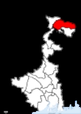
Jalpaiguri District
Encyclopedia
Jalpaiguri district is the largest district of North Bengal
, covering an area 6,245 km2. It is situated between 26° 16' and 27° 0' North latitudes and 88° 4' and 89° 53' East longitudes. The district was established in 1869.
The headquarters of the district are at Jalpaiguri
town, which is also the divisional headquarter of north Bengal and has its special importance in respect of tourism, forest, hills, tea gardens, scenic beauty and a wide variety of tribes like the Totos
, etc.
The district situated in the northern part of West Bengal
has international borders with Bhutan
and Bangladesh
in the north and south respectively and district borders with Assam
and the Darjeeling hills in the east, west and northwest.
Jalpaiguri - this narrow stretch of land lying between the Sikkim
- Darjeeling Himalayas and Gangetic West Bengal has more than often evoked a sense of both eerie and romanticism in many a heart since the early British Rule. Veined by mighty rivers like the Teesta
, Torsa
, Jaldhaka, Raidak
, Dyna, Neora, Sankosh etc. this piece of land has been aptly named as the land of 'Tea, Timber and Tourism'. A major stretch of area is bordered in the north by Bhutan and hence the name - Dooars/Duars
which mean - Door of Bhutan.
named Jalpaiguri one of the country's 250 most backward districts
(out of a total of 640
). It is one of the eleven districts in West Bengal currently receiving funds from the Backward Regions Grant Fund Programme (BRGF).
and Alipurduar.
Jalpaiguri Sadar consists of Jalpaiguri
and Rajganj municipalities and Jalpaiguri Sadar, Dhupguri, Maynaguri and Rajganj community development blocks.
Malbazar subdivision, also known as Mal subdivision, consists of Malbazar
municipality and three community development blocks: Mal, Matiali and Nagrakata.
Alipurduar subdivision consists of Alipurduar
municipality and six community development blocks: Madarihat–Birpara, Alipurduar–I, Alipurduar–II, Falakata, Kalchini and Kumargram.
Jalpaiguri is the district headquarters. There are 17 police stations, 13 development blocks, 4 municipalities.
Each subdivision contains one municipality each along with community development blocks which in turn are divided into rural areas and census towns. Siliguri
municipal corporation, which lies mainly in Darjeeling district
, has 15 out of 47 wards in Jalpaiguri district. In total there are 17 urban units: 4 municipalities, 12 census towns and 146 gram panchayat
s in this district. Also, Alipurduar
city, Alipurduar Railway Junction
, Sobhaganj
, Chechakhata
and Paschim Jitpur
are part of a urban agglomeration.
Kumargram, Kalchini, Madarihat, Nagrakata and Malbazar constituencies are reserved for Scheduled Tribes (ST) candidates. Falakata, Dhupguri, Mainaguri and Rajganj constituencies are reserved for Scheduled Castes (SC) candidates. Along with one assembly constituency from Cooch Behar district
, Kumargram, Kalchini, Alipurduar, Falakata, Madarihat and Nagrakata constituencies form the Alipurduars (Lok Sabha constituency)
, which is reserved for Scheduled Tribes (ST). Dhupguri, Mainaguri, Malbazar, Kranti, Jalpaiguri and Rajganj constituencies form the Jalpaiguri (Lok Sabha constituency)
, which also contains one assembly constituency from Cooch Behar district
.
Kumargram, Kalchini, Madarihat, Malbazar and Nagrakata constituencies will remain to be reserved for Scheduled Tribes (ST) candidates. Falakata, Dhupguri, Mainaguri, Jalpaiguri and Rajganj constituencies will be reserved for Scheduled Castes (SC) candidates. Along with one assembly constituency from Cooch Behar district
, Kumargram, Kalchini, Alipurduar, Falakata, Madarihat and Nagrakata constituencies will continue to form the Alipurduars (Lok Sabha constituency)
, which will be reserved for Scheduled Tribes (ST). Along with one assembly constituency from Cooch Behar district
, Dhupguri, Mainaguri, Jalpaiguri, Rajganj, Dabgram-Phulbari, and Malbazar constituencies will form the Jalpaiguri (Lok Sabha constituency)
, which will be reserved for Scheduled Castes (SC).
Samuktala
They are 03561, 03562, 03563, 03564, 03565, 03566.
/ Jalpaiguri Road / New Jalpaiguri
Stn. By road it is well connected with rest of the country. Air travel is available up to Bagdogra
(Siliguri
) and from there it is well connected by a 58 km. road.
Jalpaiguri district has a population
of 3,869,675, roughly equal to the nation of Liberia
or the US state of Oregon
. This gives it a ranking of 66th in India (out of a total of 640
). The district has a population density of 621 PD/sqkm . Its population growth rate
over the decade 2001-2011 was 13.77 %. Jalpaiguri has a sex ratio
of 954 females
for every 1000 males, and a literacy rate
of 73.79 %.
It is mainly inhabited by the Rajbongshi community of this area.
language distantly related to Khmer
and Vietnamese
, spoken by about 25 000.
, which was established in 1994 and has an area of 79 square kilometre.
Apart from the national parks, the district contains three wildlife sanctuaries: Buxa (located adjacent to its namesake national park), Chapramari, and lastly Jaldapara, which it shares with Cooch Behar district
.
North Bengal
North Bengal is a term used for the northern parts of Bangladesh and West Bengal. The Bangladesh part denotes the Rajshahi Division. Generally it is the area lying west of Jamuna River and north of Padma River, and includes the Barind Tract. The West Bengal part denotes Cooch Behar, Darjeeling,...
, covering an area 6,245 km2. It is situated between 26° 16' and 27° 0' North latitudes and 88° 4' and 89° 53' East longitudes. The district was established in 1869.
The headquarters of the district are at Jalpaiguri
Jalpaiguri
Jalpaiguri is a city in the state of West Bengal, India. It is the headquarters of Jalpaiguri district, and the divisional headquarters of the North Bengal region.-History:...
town, which is also the divisional headquarter of north Bengal and has its special importance in respect of tourism, forest, hills, tea gardens, scenic beauty and a wide variety of tribes like the Totos
Toto tribe
The Toto is a primitive and isolated tribal group residing only in a small enclave called Totopara in the Jalpaiguri district of West Bengal, India. Totopara is located at the foot of the Himalayas just to the south of the borderline between Bhutan and West Bengal...
, etc.
Etymology
The name Jalpaiguri came from the Bengali word jalpai meaning "olive" because of the olives which grew in the town and were seen even in 1900. The suffix guri means a place. The name can also be associated with Jalpesh, the presiding deity (Shiva) of the entire region.Geography
Presently Jalpaiguri is the part of West Bengal which is situated in North Bengal.The district situated in the northern part of West Bengal
West Bengal
West Bengal is a state in the eastern region of India and is the nation's fourth-most populous. It is also the seventh-most populous sub-national entity in the world, with over 91 million inhabitants. A major agricultural producer, West Bengal is the sixth-largest contributor to India's GDP...
has international borders with Bhutan
Bhutan
Bhutan , officially the Kingdom of Bhutan, is a landlocked state in South Asia, located at the eastern end of the Himalayas and bordered to the south, east and west by the Republic of India and to the north by the People's Republic of China...
and Bangladesh
Bangladesh
Bangladesh , officially the People's Republic of Bangladesh is a sovereign state located in South Asia. It is bordered by India on all sides except for a small border with Burma to the far southeast and by the Bay of Bengal to the south...
in the north and south respectively and district borders with Assam
Assam
Assam , also, rarely, Assam Valley and formerly the Assam Province , is a northeastern state of India and is one of the most culturally and geographically distinct regions of the country...
and the Darjeeling hills in the east, west and northwest.
Climate
The average annual rainfall is 3160 mm and the average temperature ranges from 30.9 to 10.8 degrees throughout the year. The average relative humidity is about 82%.Topography
The entire topography is crisscrossed with rivulets, rivers and hills.Jalpaiguri - this narrow stretch of land lying between the Sikkim
Sikkim
Sikkim is a landlocked Indian state nestled in the Himalayan mountains...
- Darjeeling Himalayas and Gangetic West Bengal has more than often evoked a sense of both eerie and romanticism in many a heart since the early British Rule. Veined by mighty rivers like the Teesta
Teesta River
River Teesta or Tista is said to be the lifeline of the Indian state of Sikkim, flowing for almost the entire length of the state and carving out verdant Himalayan temperate and tropical river valleys. The emerald-coloured river then forms the border between Sikkim and West Bengal before joining...
, Torsa
Torsa
Torsa is one of the Slate Islands in Argyll and Bute, Scotland.Lying east of Luing and south of Seil, the island was inhabited until the 1960s. There is now only one house on the island, which is used for holiday lets. Its main industry is farming, with cattle brought over from the neighbouring...
, Jaldhaka, Raidak
Raidak River
The Raidak River is a tributary of the Brahmaputra River, and a trans-boundary river, flows through Bhutan, India and Bangladesh.-Bhutan:...
, Dyna, Neora, Sankosh etc. this piece of land has been aptly named as the land of 'Tea, Timber and Tourism'. A major stretch of area is bordered in the north by Bhutan and hence the name - Dooars/Duars
Duars
The Dooars or Duars are the floodplains and foothills of the eastern Himalayas in North-East India around Bhutan. Duar means door in Assamese, Nepali, Maithili, Bhojpuri, Magahi and Bengali languages, and the region forms the gateway to Bhutan from India. There were 18 passages or gateways through...
which mean - Door of Bhutan.
Economy
In 2006 the Ministry of Panchayati RajMinistry of Panchayati Raj
The Ministry of Panchayati Raj is a branch of the Government of India looking after the ongoing process of decentralization and local governance in the States....
named Jalpaiguri one of the country's 250 most backward districts
Poverty in India
Poverty is widespread in India, with the nation estimated to have a third of the world's poor. According to a 2005 World Bank estimate, 41.6% of the total Indian population falls below the international poverty line of 1.25 a day...
(out of a total of 640
Districts of India
A district is an administrative division of an Indian state or territory. Districts are further subdivided, in some cases into Sub-Divisions, and otherwise directly into tehsils or talukas.District officials include:...
). It is one of the eleven districts in West Bengal currently receiving funds from the Backward Regions Grant Fund Programme (BRGF).
Administrative subdivisions
The district comprises three subdivisions: Jalpaiguri Sadar, MalbazarMalbazar subdivision
Malbazar subdivision , also known as Mal subdivision, is a subdivision of the Jalpaiguri district in the state of West Bengal, India. It consists of Malbazar municipality and three community development blocks: Mal, Metiali and Nagrakata. The three blocks contain 22 gram panchayats. The subdivision...
and Alipurduar.
Jalpaiguri Sadar consists of Jalpaiguri
Jalpaiguri
Jalpaiguri is a city in the state of West Bengal, India. It is the headquarters of Jalpaiguri district, and the divisional headquarters of the North Bengal region.-History:...
and Rajganj municipalities and Jalpaiguri Sadar, Dhupguri, Maynaguri and Rajganj community development blocks.
Malbazar subdivision, also known as Mal subdivision, consists of Malbazar
Malbazar
Malbazar , also known as Mal, is a sub-divisional town, a municipality in Jalpaiguri district, located in North Bengal, India. It lies about 65 km from Jalpaiguri and 55 km from Siliguri.-History:...
municipality and three community development blocks: Mal, Matiali and Nagrakata.
Alipurduar subdivision consists of Alipurduar
Alipurduar
Alipurduar is a sub-divisional municipal city of Jalpaiguri district, and is located at the eastern end of the district. Situated on the east bank of Kaljani River on the foothills of the Himalayas, the town is a gateway to Bhutan and North Eastern states of India...
municipality and six community development blocks: Madarihat–Birpara, Alipurduar–I, Alipurduar–II, Falakata, Kalchini and Kumargram.
Jalpaiguri is the district headquarters. There are 17 police stations, 13 development blocks, 4 municipalities.
Each subdivision contains one municipality each along with community development blocks which in turn are divided into rural areas and census towns. Siliguri
Siliguri
Siliguri is a city in the Indian state of West Bengal. It is located in the Siliguri Corridor or Chicken's Neck - a very narrow strip of land linking mainland India to its north-eastern states. It is also the transit point for air, road and rail traffic to the neighbouring countries of Nepal,...
municipal corporation, which lies mainly in Darjeeling district
Darjeeling district
Darjeeling District is the northernmost district of the state of West Bengal in eastern India in the foothills of the Himalayas. The district is famous for its beautiful hill stations and Darjeeling tea. Darjeeling is the district headquarters...
, has 15 out of 47 wards in Jalpaiguri district. In total there are 17 urban units: 4 municipalities, 12 census towns and 146 gram panchayat
Gram panchayat
Gram panchayats are local self-governments at the village or small town level in India. As of 2002 there were about 265,000 gram panchayats in India. The gram panchayat is the foundation of the Panchayat System. A gram panchayat can be set up in villages with minimum population of 300...
s in this district. Also, Alipurduar
Alipurduar
Alipurduar is a sub-divisional municipal city of Jalpaiguri district, and is located at the eastern end of the district. Situated on the east bank of Kaljani River on the foothills of the Himalayas, the town is a gateway to Bhutan and North Eastern states of India...
city, Alipurduar Railway Junction
Alipurduar Railway Junction
Alipurduar Railway Junction is a census town under Alipurduar police station of Alipurduar subdivision in Jalpaiguri district in the state of West Bengal, India.-Demographics:...
, Sobhaganj
Sobhaganj
Sobhaganj is a census town under Alipurduar police station of Alipurduar subdivision in Jalpaiguri district in the Indian state of West Bengal.-Demographics:...
, Chechakhata
Chechakhata
Chechakhata is a census town under Alipurduar police station of Alipurduar subdivision in Jalpaiguri district in the state of West Bengal, India.-Demographics:...
and Paschim Jitpur
Paschim Jitpur
Paschim Jitpur is a census town under the Alipurduar police station of the Alipurduar subdivision in the Jalpaiguri district in the Indian state of West Bengal.-Demographics:...
are part of a urban agglomeration.
Jalpaiguri Sadar subdivision
- JalpaiguriJalpaiguriJalpaiguri is a city in the state of West Bengal, India. It is the headquarters of Jalpaiguri district, and the divisional headquarters of the North Bengal region.-History:...
: municipality - Jalpaiguri (Community development block)Jalpaiguri (Community development block)Jalpaiguri is an administrative division in Jalpaiguri Sadar subdivision of Jalpaiguri district in the Indian state of West Bengal. Jalpaiguri police station serves this block...
consists of rural areas only with 14 gram panchayats. - Maynaguri (Community development block)Maynaguri (Community development block)Maynaguri is an administrative division in Jalpaiguri Sadar subdivision of Jalpaiguri district in the Indian state of West Bengal. Maynaguri police station serves this block...
consists of rural areas with 16 gram panchayats and one census town: MainaguriMainaguriMainaguri is a census town in Jalpaiguri district in the Indian state of West Bengal. It is known as the "Gate way of Duars" and is a regionally significant tourist destination for its temple to Shiva.-History:...
. - Dhupguri (Community development block)Dhupguri (Community development block)Dhupguri is an administrative division in Jalpaiguri Sadar subdivision of Jalpaiguri district in the Indian state of West Bengal. Dhupguri and Banarhat police stations serve this block. Headquarters of this block is at Dhupguri...
consists of rural areas with 16 gram panchayats and two census towns: Banarhat Tea GardenBanarhat Tea GardenBanarhat is a census town in Jalpaiguri district in the state of West Bengal, India.-Demographics:...
and GairkataGairkataGairkata is a census town in Jalpaiguri district in the state of West Bengal, India.-Demographics: India census, Gairkata had a population of 8713. Males constitute 51% of the population and females 49%. Gairkata has an average literacy rate of 66%, higher than the national average of 59.5%: male...
. - Rajganj (Community development block)Rajganj (Community development block)Rajganj is an administrative division in Jalpaiguri Sadar subdivision of Jalpaiguri district in the Indian state of West Bengal. Rajganj and Bhaktinagar police stations serve this block...
consists of rural areas only with 12 gram panchayats.
Malbazar subdivision
- MalMalbazarMalbazar , also known as Mal, is a sub-divisional town, a municipality in Jalpaiguri district, located in North Bengal, India. It lies about 65 km from Jalpaiguri and 55 km from Siliguri.-History:...
: municipality - Mal (Community development block)Mal (Community development block)Mal is an administrative division in Malbazar subdivision of Jalpaiguri district in the Indian state of West Bengal. Mal police station serves this block...
consists of rural areas only with 12 gram panchayats. - Matiali (Community development block)Matiali (Community development block)Matiali is an administrative division in Malbazar subdivision of Jalpaiguri district in the Indian state of West Bengal. Metiali police station serves this block...
consists of rural areas only with 5 gram panchayats. - Nagrakata (Community development block)Nagrakata (Community development block)Nagrakata is an administrative division in Malbazar subdivision of Jalpaiguri district in the Indian state of West Bengal. Nagrakata and Banarhat police stations serve this block...
consists of rural areas only with 5 gram panchayats.
Alipurduar subdivision
- AlipurduarAlipurduarAlipurduar is a sub-divisional municipal city of Jalpaiguri district, and is located at the eastern end of the district. Situated on the east bank of Kaljani River on the foothills of the Himalayas, the town is a gateway to Bhutan and North Eastern states of India...
: municipality - Madarihat-Birpara (Community development block)Madarihat-Birpara (Community development block)Madarihat-Birpara is an administrative division in Alipurduar subdivision of Jalpaiguri district in the Indian state of West Bengal. Madarihat and Birpara police stations serve this block...
consists of rural areas only with 10 gram panchayats. - Alipurduar I (Community development block)Alipurduar I (Community development block)Alipurduar I is an administrative division in Alipurduar subdivision of Jalpaiguri district in the Indian state of West Bengal. Alipurduar police station serves this block. Headquarters of this block is at Panchkalguri...
consists of rural areas with 11 gram panchayats and four census towns: Paschim JitpurPaschim JitpurPaschim Jitpur is a census town under the Alipurduar police station of the Alipurduar subdivision in the Jalpaiguri district in the Indian state of West Bengal.-Demographics:...
, ChechakhataChechakhataChechakhata is a census town under Alipurduar police station of Alipurduar subdivision in Jalpaiguri district in the state of West Bengal, India.-Demographics:...
, Alipurduar Railway JunctionAlipurduar Railway JunctionAlipurduar Railway Junction is a census town under Alipurduar police station of Alipurduar subdivision in Jalpaiguri district in the state of West Bengal, India.-Demographics:...
and Bholar DabriBholar DabriBholar Dabri is a census town under Alipurduar police station of Alipurduar subdivision, in Jalpaiguri district in the state of West Bengal, India.-Demographics:...
. - Alipurduar II (Community development block)Alipurduar II (Community development block)Alipurduar II is an administrative division in Alipurduar subdivision of Jalpaiguri district in the Indian state of West Bengal. Alipurduar police station serves this block. Headquarters of this block is at Josodanga. There is one census towns in this block: Sobhaganj.-Geography:Sobhaganj is...
consists of rural areas with 11 gram panchayats and one census town: SobhaganjSobhaganjSobhaganj is a census town under Alipurduar police station of Alipurduar subdivision in Jalpaiguri district in the Indian state of West Bengal.-Demographics:...
. - Falakata (Community development block)Falakata (Community development block)Falakata is an administrative division in Alipurduar subdivision of Jalpaiguri district in the Indian state of West Bengal. Falakata police station serves this block. Headquarters of this block is at Falakata. There is one census town in this block: Falakata.-Geography:Falakata is located at...
consists of rural areas with 12 gram panchayats and one census town: FalakataFalakataFalakata is a census town and police station of Alipurduar subdivision in Jalpaiguri district in the state of West Bengal, India.-Geography:...
. - Kalchini (Community development block)Kalchini (Community development block)Kalchini is an administrative division in Alipurduar subdivision of Jalpaiguri district in the Indian state of West Bengal. Kalchini and Jaygaon police stations serve this block. Headquarters of this block is at Hamiltanganj. There are two census towns in this block: Jaygaon and Uttar...
consists of rural areas with 11 gram panchayats and two census towns: Jaygaon and Uttar LatabariUttar LatabariUttar Latabari is a census town under Kalchini police station of Alipurduar subdivision in Jalpaiguri district in the Indian state of West Bengal.-Demographics:...
. - Kumargram (Community development block)Kumargram (Community development block)Kumargram is an administrative division in Alipurduar subdivision of Jalpaiguri district in the Indian state of West Bengal. Kumargram police station serves this block. Headquarters of this block is at Kumargram. There is one census town in this block: Uttar Kamakhyaguri.-Geography:Kumargram is...
consists of rural areas with 11 gram panchayats and one census town: Uttar KamakhyaguriUttar KamakhyaguriUttar Kamakhyaguri is a census town under Kumargram police station of Alipurduar subdivision in Jalpaiguri district in the Indian state of West Bengal.-Demographics:...
.
Assembly constituencies
The district is divided into 12 assembly constituencies:- Kumargram (ST)Kumargram (Vidhan Sabha constituency)Kumargarm is an assembly constituency in Jalpaiguri district in the Indian state of West Bengal. The seat is reserved for scheduled tribes.-Extent:As per orders of the Delimitation Commission, No...
(assembly constituency no. 10), - Kalchini (ST)Kalchini (Vidhan Sabha constituency)Kalchini is an assembly constituency in Jalpaiguri district in the Indian state of West Bengal. The seat is reserved for scheduled tribes.-Extent:As per orders of the Delimitation Commission, No...
(assembly constituency no. 11), - AlipurduarsAlipurduars (Vidhan Sabha constituency)Alipurduars is an assembly constituency in Jalpaiguri district in the Indian state of West Bengal.-Extent:As per orders of the Delimitation Commission, No...
(assembly constituency no. 12), - Falakata (SC)Falakata (Vidhan Sabha constituency)Falakata is an assembly constituency in Jalpaiguri district in the Indian state of West Bengal. The seat is reserved for scheduled castes.-Extent:As per orders of the Delimitation Commission, No...
(assembly constituency no. 13), - Madarihat (ST)Madarihat (Vidhan Sabha constituency)Madarihat is an assembly constituency in Jalpaiguri district in the Indian state of West Bengal. The seat is reserved for scheduled tribes.-Extent:As per orders of the Delimitation Commission, No...
(assembly constituency no. 14), - Dhupguri (SC)Dhupguri (Vidhan Sabha constituency)Dhupguri is an assembly constituency in Jalpaiguri district in the Indian state of West Bengal. The seat is reserved for scheduled castes.-Extent:As per orders of the Delimitation Commission, No...
(assembly constituency no. 15), - Nagrakata (ST)Nagrakata (Vidhan Sabha constituency)Nagrakata is an assembly constituency in Jalpaiguri district in the Indian state of West Bengal. The seat is reserved for scheduled tribes.-Extent:As per orders of the Delimitation Commission, No...
(assembly constituency no. 16), - Maynaguri (SC)Maynaguri (Vidhan Sabha constituency)Maynaguri is an assembly constituency in Jalpaiguri district in the Indian state of West Bengal. The seat is reserved for scheduled castes.-Extent:...
(assembly constituency no. 17), - Mal (ST)Mal (Vidhan Sabha constituency)Mal is an assembly constituency in Jalpaiguri district in the Indian state of West Bengal. The seat is reserved for scheduled tribes.-Extent:...
(assembly constituency no. 18), - KrantiKranti (Vidhan Sabha constituency)Kranti was an assembly constituency in Jalpaiguri district in the Indian state of West Bengal. As a consequence of the order of the Delimitation Commission Kranti ceases to exist from 2011 and the new Dabgram-Phulbari comes into being.-1977-2006:In the 2006 state assembly elections, Fazlul...
(assembly constituency no. 19), - JalpaiguriJalpaiguri (Vidhan Sabha constituency)Jalpaiguri is an assembly constituency in Jalpaiguri district in the Indian state of West Bengal. The seat is reserved for scheduled castes.-Extent:As per orders of the Delimitation Commission, No...
(assembly constituency no. 20) and - Rajganj (SC)Rajganj (Vidhan Sabha constituency)Rajganj is an assembly constituency in Jalpaiguri district in the Indian state of West Bengal. The seat is reserved for scheduled castes.-Extent:As per orders of the Delimitation Commission, No...
(assembly constituency no. 21).
Kumargram, Kalchini, Madarihat, Nagrakata and Malbazar constituencies are reserved for Scheduled Tribes (ST) candidates. Falakata, Dhupguri, Mainaguri and Rajganj constituencies are reserved for Scheduled Castes (SC) candidates. Along with one assembly constituency from Cooch Behar district
Cooch Behar District
Cooch Behar district is a district of the state of West Bengal, India, as well as the district's namesake town. During the British Raj, the town of Cooch Behar was the seat of a princely state of Koch Bihar, ruled by the Koch dynasty....
, Kumargram, Kalchini, Alipurduar, Falakata, Madarihat and Nagrakata constituencies form the Alipurduars (Lok Sabha constituency)
Alipurduars (Lok Sabha constituency)
Alipurduars Lok Sabha constituency is one of the 543 parliamentary constituencies in India. The constituency centres on Alipurduar in West Bengal. The seat is reserved for scheduled tribes.-Assembly segments:...
, which is reserved for Scheduled Tribes (ST). Dhupguri, Mainaguri, Malbazar, Kranti, Jalpaiguri and Rajganj constituencies form the Jalpaiguri (Lok Sabha constituency)
Jalpaiguri (Lok Sabha constituency)
Jalpaiguri is one of the 543 parliamentary constituencies in India. The constituency centres on Jalpaiguri in West Bengal. The constituency is reserved for Scheduled castes .-Assembly segments:...
, which also contains one assembly constituency from Cooch Behar district
Cooch Behar District
Cooch Behar district is a district of the state of West Bengal, India, as well as the district's namesake town. During the British Raj, the town of Cooch Behar was the seat of a princely state of Koch Bihar, ruled by the Koch dynasty....
.
Impact of delimitation of constituencies
As per order of the Delimitation Commission in respect of the delimitation of constituencies in the West Bengal, the district will be divided into 12 assembly constituencies:- Kumargram (ST)Kumargram (Vidhan Sabha constituency)Kumargarm is an assembly constituency in Jalpaiguri district in the Indian state of West Bengal. The seat is reserved for scheduled tribes.-Extent:As per orders of the Delimitation Commission, No...
(assembly constituency no. 10), - Kalchini (ST)Kalchini (Vidhan Sabha constituency)Kalchini is an assembly constituency in Jalpaiguri district in the Indian state of West Bengal. The seat is reserved for scheduled tribes.-Extent:As per orders of the Delimitation Commission, No...
(assembly constituency no. 11), - AlipurduarsAlipurduars (Vidhan Sabha constituency)Alipurduars is an assembly constituency in Jalpaiguri district in the Indian state of West Bengal.-Extent:As per orders of the Delimitation Commission, No...
(assembly constituency no. 12), - Falakata (SC)Falakata (Vidhan Sabha constituency)Falakata is an assembly constituency in Jalpaiguri district in the Indian state of West Bengal. The seat is reserved for scheduled castes.-Extent:As per orders of the Delimitation Commission, No...
(assembly constituency no. 13), - Madarihat (ST)Madarihat (Vidhan Sabha constituency)Madarihat is an assembly constituency in Jalpaiguri district in the Indian state of West Bengal. The seat is reserved for scheduled tribes.-Extent:As per orders of the Delimitation Commission, No...
(assembly constituency no. 14), - Dhupguri (SC)Dhupguri (Vidhan Sabha constituency)Dhupguri is an assembly constituency in Jalpaiguri district in the Indian state of West Bengal. The seat is reserved for scheduled castes.-Extent:As per orders of the Delimitation Commission, No...
(assembly constituency no. 15), - Maynaguri (SC)Maynaguri (Vidhan Sabha constituency)Maynaguri is an assembly constituency in Jalpaiguri district in the Indian state of West Bengal. The seat is reserved for scheduled castes.-Extent:...
(assembly constituency no. 16), - Jalpaiguri (SC)Jalpaiguri (Vidhan Sabha constituency)Jalpaiguri is an assembly constituency in Jalpaiguri district in the Indian state of West Bengal. The seat is reserved for scheduled castes.-Extent:As per orders of the Delimitation Commission, No...
(assembly constituency no. 17), - Rajganj (SC)Rajganj (Vidhan Sabha constituency)Rajganj is an assembly constituency in Jalpaiguri district in the Indian state of West Bengal. The seat is reserved for scheduled castes.-Extent:As per orders of the Delimitation Commission, No...
(assembly constituency no. 18), - Dabgram-PhulbariDabgram-Phulbari (Vidhan Sabha constituency)Dabgram-Phulbari is an assembly constituency in Jalpaiguri district in the Indian state of West Bengal. The Delimitation Commission has abolished the Kranti , and formed the new Dabgram-Phulbari .-Extent:As per orders of the Delimitation Commission, No...
(assembly constituency no. 19), - Mal (ST)Mal (Vidhan Sabha constituency)Mal is an assembly constituency in Jalpaiguri district in the Indian state of West Bengal. The seat is reserved for scheduled tribes.-Extent:...
(assembly constituency no. 20) and - Nagrakata (ST)Nagrakata (Vidhan Sabha constituency)Nagrakata is an assembly constituency in Jalpaiguri district in the Indian state of West Bengal. The seat is reserved for scheduled tribes.-Extent:As per orders of the Delimitation Commission, No...
(assembly constituency no. 21).
Kumargram, Kalchini, Madarihat, Malbazar and Nagrakata constituencies will remain to be reserved for Scheduled Tribes (ST) candidates. Falakata, Dhupguri, Mainaguri, Jalpaiguri and Rajganj constituencies will be reserved for Scheduled Castes (SC) candidates. Along with one assembly constituency from Cooch Behar district
Cooch Behar District
Cooch Behar district is a district of the state of West Bengal, India, as well as the district's namesake town. During the British Raj, the town of Cooch Behar was the seat of a princely state of Koch Bihar, ruled by the Koch dynasty....
, Kumargram, Kalchini, Alipurduar, Falakata, Madarihat and Nagrakata constituencies will continue to form the Alipurduars (Lok Sabha constituency)
Alipurduars (Lok Sabha constituency)
Alipurduars Lok Sabha constituency is one of the 543 parliamentary constituencies in India. The constituency centres on Alipurduar in West Bengal. The seat is reserved for scheduled tribes.-Assembly segments:...
, which will be reserved for Scheduled Tribes (ST). Along with one assembly constituency from Cooch Behar district
Cooch Behar District
Cooch Behar district is a district of the state of West Bengal, India, as well as the district's namesake town. During the British Raj, the town of Cooch Behar was the seat of a princely state of Koch Bihar, ruled by the Koch dynasty....
, Dhupguri, Mainaguri, Jalpaiguri, Rajganj, Dabgram-Phulbari, and Malbazar constituencies will form the Jalpaiguri (Lok Sabha constituency)
Jalpaiguri (Lok Sabha constituency)
Jalpaiguri is one of the 543 parliamentary constituencies in India. The constituency centres on Jalpaiguri in West Bengal. The constituency is reserved for Scheduled castes .-Assembly segments:...
, which will be reserved for Scheduled Castes (SC).
Police stations
There are 16 police stations in the district, viz.:- AlipurduarAlipurduarAlipurduar is a sub-divisional municipal city of Jalpaiguri district, and is located at the eastern end of the district. Situated on the east bank of Kaljani River on the foothills of the Himalayas, the town is a gateway to Bhutan and North Eastern states of India...
- Banarhat
- Bhaktinagar
- BirparaBirparaBirpara is a small commercial town in the centre of the Dooars region of Jalpaiguri district. It is a hub for transportation and trade for the tea garden region of the area.-Etymology:Birpara got its name from the conjunction of two words...
- DhupguriDhupguriDhupguri is a town, municipality in Jalpaiguri district in the state of West Bengal, India. It is one of the main business centre of Dooars area. Dhupguri municipality was established in 2001.-Geography:Dhupguri is located at...
- FalakataFalakataFalakata is a census town and police station of Alipurduar subdivision in Jalpaiguri district in the state of West Bengal, India.-Geography:...
- JaigaonJaigaonJaigaon is a small town in Jalpaiguri district in the Indian state of West Bengal, near the Bhutan border. The town lies at the gateway to Bhutan - Phuentsholing, and is thus a very thriving place of trade...
- Jalpaiguri (Kotwali)
- Kalchini
- Kumargram
- MadarihatMadarihatMadarihat is a small village located in the Alipurduar subdivision of Jalpaiguri district, West Bengal, India. This village is situated on the outskirts of Jaldapara Wildlife Sanctuary which is famous for Indian rhinoceros...
- MalbazarMalbazarMalbazar , also known as Mal, is a sub-divisional town, a municipality in Jalpaiguri district, located in North Bengal, India. It lies about 65 km from Jalpaiguri and 55 km from Siliguri.-History:...
- MatelliMatelliMatiali or Matelli is a block under Malbazar subdivision in Jalpaiguri district, West Bengal, India.-Schools and Tea Garden:THERE ARE TWO HIGH SCHOOLS & ONE JUNIOR GIRLS SCHOOL:1. MATELLI HIGH SCHOOL2. RASTRABHASA HINDI HIGH SCHOOL3...
- MainaguriMainaguriMainaguri is a census town in Jalpaiguri district in the Indian state of West Bengal. It is known as the "Gate way of Duars" and is a regionally significant tourist destination for its temple to Shiva.-History:...
- NagrakataNagrakataNagrakata is head quarters of Nagrakata in Malbazar subdivision of Jalpaiguri district, West Bengal, India.Tea Research Association is located here.-Tea Garden:...
- Rajganj
Samuktala
Telephone districts
There are six telephone area codes of Jalpaiguri district.They are 03561, 03562, 03563, 03564, 03565, 03566.
Transport
It is well connected by rail, road and air from any part of the country. One can avail train up to JalpaiguriJalpaiguri
Jalpaiguri is a city in the state of West Bengal, India. It is the headquarters of Jalpaiguri district, and the divisional headquarters of the North Bengal region.-History:...
/ Jalpaiguri Road / New Jalpaiguri
New Jalpaiguri
New Jalpaiguri is a major railway station of the city of Siliguri in the Indian state of West Bengal. The station is popularly known by its acronym NJP...
Stn. By road it is well connected with rest of the country. Air travel is available up to Bagdogra
Bagdogra
Bagdogra is a small town in the Darjeeling district of West Bengal, India, which is surrounded by tea gardens. Bagdogra is well connected by rail and air to the rest of the country. Bagdogra Airport is the only airport in North Bengal, which is now an International Airport. -References:...
(Siliguri
Siliguri
Siliguri is a city in the Indian state of West Bengal. It is located in the Siliguri Corridor or Chicken's Neck - a very narrow strip of land linking mainland India to its north-eastern states. It is also the transit point for air, road and rail traffic to the neighbouring countries of Nepal,...
) and from there it is well connected by a 58 km. road.
Demographics
According to the 2011 census2011 census of India
The 15th Indian National census was conducted in two phases, houselisting and population enumeration. Houselisting phase began on April 1, 2010 and involved collection of information about all buildings...
Jalpaiguri district has a population
Demographics of India
The demographics of India are inclusive of the second most populous country in the world, with over 1.21 billion people , more than a sixth of the world's population. Already containing 17.5% of the world's population, India is projected to be the world's most populous country by 2025, surpassing...
of 3,869,675, roughly equal to the nation of Liberia
Liberia
Liberia , officially the Republic of Liberia, is a country in West Africa. It is bordered by Sierra Leone on the west, Guinea on the north and Côte d'Ivoire on the east. Liberia's coastline is composed of mostly mangrove forests while the more sparsely populated inland consists of forests that open...
or the US state of Oregon
Oregon
Oregon is a state in the Pacific Northwest region of the United States. It is located on the Pacific coast, with Washington to the north, California to the south, Nevada on the southeast and Idaho to the east. The Columbia and Snake rivers delineate much of Oregon's northern and eastern...
. This gives it a ranking of 66th in India (out of a total of 640
Districts of India
A district is an administrative division of an Indian state or territory. Districts are further subdivided, in some cases into Sub-Divisions, and otherwise directly into tehsils or talukas.District officials include:...
). The district has a population density of 621 PD/sqkm . Its population growth rate
Family planning in India
Family planning in India is based on efforts largely sponsored by the Indian government. In the 1965-2009 period, contraceptive usage has more than tripled and the fertility rate has more than halved , but the national fertility rate is still high enough to cause long-term population growth...
over the decade 2001-2011 was 13.77 %. Jalpaiguri has a sex ratio
Sex ratio
Sex ratio is the ratio of males to females in a population. The primary sex ratio is the ratio at the time of conception, secondary sex ratio is the ratio at time of birth, and tertiary sex ratio is the ratio of mature organisms....
of 954 females
Women in India
The status of women in India has been subject to many great changes over the past few millennia. From equal status with men in ancient times through the low points of the medieval period, to the promotion of equal rights by many reformers, the history of women in India has been eventful...
for every 1000 males, and a literacy rate
Literacy in India
Literacy in India is key for socio-economic progress, and the Indian literacy rate grew to 74.04% in 2011 from 12% at the end of British rule in 1947. Although this was a greater than sixfold improvement, the level is well below the world average literacy rate of 84%, and India currently has the...
of 73.79 %.
It is mainly inhabited by the Rajbongshi community of this area.
Languages
Languages include Bijori, a MundaMunda languages
-Anderson :Gregory Anderson's 1999 proposal is as follows. Individual languages are highlighted in italics.*North Munda **Korku**Kherwarian***Santhali***Mundari*South Munda **Kharia–Juang***Juang***Kharia...
language distantly related to Khmer
Khmer language
Khmer , or Cambodian, is the language of the Khmer people and the official language of Cambodia. It is the second most widely spoken Austroasiatic language , with speakers in the tens of millions. Khmer has been considerably influenced by Sanskrit and Pali, especially in the royal and religious...
and Vietnamese
Vietnamese language
Vietnamese is the national and official language of Vietnam. It is the mother tongue of 86% of Vietnam's population, and of about three million overseas Vietnamese. It is also spoken as a second language by many ethnic minorities of Vietnam...
, spoken by about 25 000.
Flora and fauna
In 1992 Jalpaiguri district became home to Buxa National Park, which has an area of 117 square kilometre. It is also home to Gorumara National ParkGorumara National Park
Gorumara National Park is a National Park in northern West Bengal, India. Located in the Terai region of the Himalayan foothills, it is a medium-sized park with grasslands and forests. It is primarily known for its population of Indian Rhinoceros...
, which was established in 1994 and has an area of 79 square kilometre.
Apart from the national parks, the district contains three wildlife sanctuaries: Buxa (located adjacent to its namesake national park), Chapramari, and lastly Jaldapara, which it shares with Cooch Behar district
Cooch Behar District
Cooch Behar district is a district of the state of West Bengal, India, as well as the district's namesake town. During the British Raj, the town of Cooch Behar was the seat of a princely state of Koch Bihar, ruled by the Koch dynasty....
.