
Bijapur, Karnataka
Encyclopedia
BijapurUrdu
:بیجاپور city is the district headquarters of Bijapur District of Karnataka
state. Bijapur city is well known for its historical monuments of architectural importance built during the rule of Adil Shahi
dynasty. Bijapur is located 530 km northwest of Bangalore
and about 550 km from Mumbai
.and 384 km from Hyderabad.
Bijapur's urban population as per 2011 census is 3.26 lakhs.So, efforts are being made to upgrade the CMC into a Municipal Corporation(like the current corporations Hubli-Dharwad, Belgaum
, Gulbarga
, Bellary
, Davangere, Tumkur
, Mangalore
, Mysore, Bangalore
along with Shimoga which would help in getting more funds for the development of city. As per norms, the city should have a minimum population of three lakh for a Municipal Corporation to be formed per KMC act.
The city was established in the 10th-11th centuries by the Kalyani Chalukyas and was known as Vijayapura (City of victory). The city came under the influence of the Khilji
Sultanate
in Delhi
by the late 13th century. In 1347, the area was conquered by the Bahmani Sultanate
of Gulbarga
. By this time, the city was being referred as Vijapur or Bijapur.
Bijapur, Karnataka
split into five splinter states known as the Deccan sultanates
, one of which was Bijapur, ruled by the kings of the Adil Shahi
dynasty (1490–1686). The city of Bijapur owes much of its greatness to Yusuf Adil Shah, the founder of the independent state of Bijapur. The rule of this dynasty ended in 1686, when Bijapur was conquered during the reign of Mughal
emperor Aurangzeb
. After the 1818 defeat of the Peshwa by the British
in the Third Anglo-Maratha War
, Bijapur passed into the hands of the British East India Company
, and was assigned to the princely state
Satara
.
 In 1848 the territory of Satara, along with Bijapur, was annexed to Britain's Bombay Presidency
when the last ruler died without a male heir. The British carved a new district by the name Kaladagi. The district included present-day Bijapur and Bagalkot
districts. Bijapur was made the administrative headquarters of the district in 1885, when the headquarters were moved from Bagalkot. After India's Independence in 1947, the district became part of Bombay state
, and was reassigned to Mysore State
, later Karnataka, in 1956. The former southern taluks of the district were separated in 1997 to form Bagalkot District.
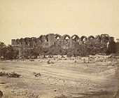
and the remains of the city. The citadel, built by Yusuf Adil Shah, a mile in circuit, is of great strength, well built of the most massive materials, and encompassed by a ditch 100 yards (91.4 m) wide, formerly supplied with water, but now nearly filled up with rubbish, so that its original depth cannot be discovered.The fort, which was completed by Au Adil Shah in 1566, is surrounded by a wall 6 m. in circumference. This wall is from 30 to 50 ft (15.2 m) high, and is strengthened with ninety-six massive bastions of various designs. In addition there are ten others at the various gateways. The width is about 25 ft (7.6 m); from bastion to bastion runs a battlemented curtained wall about 10 ft (3 m) high. The whole is surrounded by a deep moat 30 to 40 ft (12.2 m) broad. Inside these walls the Bijapur kings bade defiance to all comers. Outside the walls are the remains of a vast city, now for the most part in ruins, but the innumerable tombs, mosques, caravanserais and other edifices, which have resisted the havoc of time, afford abundant evidence of the ancient splendour of the place.
Badami
, Aihole
, and Pattadakal
, near Bijapur, are noted for their historical temples in the Chalukya architectural style.
 Bijapur is rich in historical attractions, mainly related to Islamic architecture
, especially those of the Bijapur Fort
.
Torvi is located merely 5 km from Bijapur.
The Narasimha temple, which is built underground is very close to Adil Shahi's
Sangeeth mahal. Nearby this temple, another Hindu temple of Devi Lakshmi is located.
The people of Bijapur have a trend to visit these temples every Saturday.
•The place is an important tourist place in the country, the former capital of the Adilshahi dynasty, situated about 579 km to the north-west of Bangalore. The Hubli-Sholapur railway line traverses via this place. The Kalyana Chalukya kings made it a sub-capital according to an inscription of 1073. It is believed that Jaina Poet Nagachandra, 12th century, had his residence here. The place had old names like Vijayapura, Vidyapura and Mohamudpura. For nearly 200 years from 1489 to1686, this was the seat of the Adilshahi Dynasty.
•Bijapur City was also held by Aurangzeb, the Nizam, Savanur Nawab, Satara Chatrapati and finally the British. Foreign travelers like Duarte Barbosa, Varthema, Poser, Mandeslo and Travernier visited this place.
•The Ibrahim Rauza and the Gol Gumbaz are the most impressive monuments at Bijapur. A brief survey of spots of note in the city is given below.
•Ain-ul-mulk’s tomb and mosque Lies on the eastern outskirts of the city and is the solid structure in square, surrounded by a fair proportioned dome. The tomb belongs to Ain-ul-mulk. Close by is the much adorned mosque and the building is plastered.
'•Ali Adilshah I’s tomb lies in the south-west part of the City. Ali Adilshah’s Tomb is a simple modest building containing an outer row of five arches surrounding a central chamber and is the earliest royal mausoleum in Bijapur.
'•Ali Adil Sha II’s tomb is located to the north-west of the citadel, and is housed in a big square roofless structure consisting of incomplete arches in dark basalt. This incomplete structure is 215 feet (65.5 m) square and on the raised platform stand the incomplete arches. In the centre on the elevated platform are the tombs.
'•Ali Shahi Pir’s mosque and tomb is a square massive structure, its mihrab is remarkable in some ways. The tomb of the saint is outside the north-east gate of the mosque.
•Amin Dargah Is considered as the most sacred in the city and is situated about 1.5 km to the west of Bijapur. The tomb of Amin-ud-din is on the high ground and conspicuous landmark for considerable distance round about.
'•Anand Mahal Is to the west of Gagana Mahal and in the premises of the citadel stands this two-storeyed mansion. This was constructed by Ibrahim Adil Sha II in 1589, exclusively for music and dance. The roof was ornamented with stucco work. The Ananda Mahal presently is being used by the State for Government offices.
•Andu Masjid stands a little away from the citadel to the west of the jumnal road. It is a two-storeyed structure, upper floor being a prayer chamber while the ground is a hall. There is no pulpit in the mosque and probably it was restricted to the prayer of women. A Persian inscription here quotes that the mosque was constructed in 1608 by Itbar Khan, one of the nobles in the Court of Adil Shai II.
•Aras Mahal Is to the south-east of Adalat Mahal and was once a joy resort of Ali II. It is now the residence of the District Surgeon.
•The Archaeological Museum It has several curious objects like inscriptions, sculptures, paintings, manuscripts, and weapons etc., displayed. It is near Gol Gumbaz and is run by the Archaeological Survey.
•Ark-Killa the citadel is at the centre of the city. It is also most important part of Bijapur. Yusuf Adilshah chose it as the site for his fort. The present citadel is nearly circular. Its defenses are a strong wall with several bastions of considerable strength on the south and east.
•Asar Mahal on the crest of the eastern glacis of the citadel is the Asar Mahal. In about 1646 it was constructed by Muhammad Shah and was earlier called as Adalat Mahal. The walls and ceilings of the rooms bear paintings of landscapes and various designs. The room of the south side of the gilded hall is a gorgeously painted apartment. These paintings had been whitewashed by the orders of Aurangzeb and later restored. There is a big square tank outside in front of the building.
•Aurangzeb Idgah Is a large square enclosure built by Aurangzeb in 1682 after the occupation of the city as a gathering place for Muslims on important days.
•Bukhati Masjid is believed to have been constructed by Chandbibi for a moulvi of the Bukhari family. On a door is a Persian Inscription.
•Chand Bavadi is a well constructed by Ali Adil Shah I in honor of his wife Chand Bibi in the year 1579. It is at the west corner of the town. The entrance is spanned by a single arch, approached by a descending flight of steps.
•Chota Asar is a small building, remarkable for the amount of rich ornamentation in stucco which covers the wall, ceiling and a portion of the façade.
•Chini Mahal or Faroukh Mahal is an edifice that consists of a big lofty durbar hall in the centre and series of rooms in the wings. Yusuf Adil Shsh constructed it. For its sheer size and loftiness none of the hall in any other palace of Bijapur can be compared with it.
•Ibrahim Rauza is situated on the western outskirts of the city. Ibrahim Rauza comprises two buildings, a magnificent tomb and a remarkable mosque enveloped by a garden. Facing each other, these twin buildings have a fountain in between them. A Persian inscription here records the construction of this Rauza in 1626. These buildings stand on a raised terrace supported by arches in a large rectangular enclosure with a high entrance tower in the centre of the north side, adorned with four graceful minarets. This is the most ornate building in Bijapur. Both the buildings have square plans with four minarets at the corners and a bulbous dome at the centre, which emerges from lotus petals. Cousins called the building as “The Taj Mahal of the Deccan”.
••Malik-Karim-ud-dins mosque is standing at the east of the Chini Mahal. The mosque appears to be a Hindu temple originally. An inscription inside the pillar in old Kannada characters dated 1320 A.D. says the name of the builder of the upper part as Ravayya of Salotgi. It is a rectangular enclosure with a fine vestibule in front, the portico of which spreading into wings fills the forepart of the mosque. According to another version, earlier it was a Hindu college, converted into a mosque.
•Jami Masjid is the largest and oldest mosque in the Deccan. It is at 1200 yards to the east of the citadel. Ali Adil Shah I, after his triumphant victory over Vijayanagara built this mosque. It is a mosque, rectangle in shape, about 400 feet (121.9 m) from east to west and 280 feet (85.3 m) from north to south. The main entrance is from the east side and there is a pavilion ascribed to Aurangzeb at the entrance. Including the entire big open court spread between two wings, the mosque occupies an area of 116300 square feet (10,804.6 m²) and unmatched by any building in Bijapur. The columns in the main building divide the floor into 45 equal squares. The most beautiful feature is the dome of this building which is highly proportionate. The mihrab here is gorgeously painted.
•Jod Gumbaz is behind the Government High School. A pair of tombs is housed in this. The floors of both the tombs are at a very considerable elevation, as the graves have been built at floor level. Both the buildings have galleries within the domes.
Afzal khan’s cenotaph is at a distance of about four km from the gate way of Shahapur. There is a mosque too. Afzal khan commenced the construction of his own splendid tomb in his life time. But he was not buried in the tomb. About one km towards south of Afzal khan’s tomb are his wives’ tombs on a masonry platform consisting of 11 rows of graves. There are 63 graves and one is empty. It is said that Afzal Khan believed in one astrologer’s prediction that he would never return to Bijapur when he went to meet Shivaji, and had all his 64 wives drowned before his journey, except one who escaped. That is how one grave is empty.
•GOL GUMBAZ Standing majestically near the railway station, Gol Gumbaz is unsurpassed by any other building in simple mass and dominates the landscape round about. In magnitude few buildings in India can be compared with it. Its noble proportions and the splendid dome are to be seen to fullest advantage from a distance. The Gumbaz comprises a mosque, a nagarakhana or drum house, a gateway and a sarai with other amenities required for the royal sepulture, all within the single walled compound. Gumbaz contains a big square hall surrounded by four raised walls, buttressed up by octagonal towers at the corners and the whole is surmounted by a hemispherical dome, the biggest in India, more than 120 feet (36.6 m) in diameter at the bottom. At the base of the dome, at the exterior, a platform runs round the building protected by a masonry parapet on the outer side. The whispering gallery that runs round inside the dome is another unusual feature. On entering the building, even slight whisper could be heard from one corner to the other. At the centre of the square hall are tombs of Muhummad Shah (1626–56) and his family. The whole building covers an area of 18000 square feet (1,672.3 m²).
•Green Stone Sarchophagus is a tomb at a little distance to the south of Ali I’s tomb. It is finely cut and molded in a dark greenish black-basalt, standing on a raised large platform. The name of the buried person is not known.
•Jala Manjil is a small tidy square structure, to the north of the Sat-Manzil standing in the middle of a dry reservoir, which was exclusively meant as a pleasure spot for the royal family.
•Landa Kasab Gun lies in the middle of the southern fort of the City. It weighs about 46.5 tons, and there is another small gun on the same bastion. Though unprotected for 300 years from the rig ours of climate, these guns show no signs of decay.
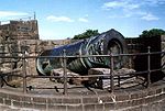
•Malik-i-Maidan the great gun of Bijapur, is placed to the north of Phatka gate in a tower. This is the biggest gun in Bijapur, weighing about 55 tons and was cast at Ahmednagar in 1549 by a Turkish Officer in the service of Burhan Nizamshah and this information is engraved on it. The muzzle is fashioned into the form of the head of a lion or dragon.
•Sat-Manzil is part of the mansion that now remains to the west of the citadel. In this dilapidated five-storeyed building are traces of painting, and stucco work has been executed on the ceiling of the different floors.
•Taj Bavadi to the west of the Mecca gateway, about 100 yards away is Taj Bavadi. The well is 223 feet (68 m) in square and 52 feet (15.8 m) deep.
••Mehatar Mahal is about 260 yards to the south of the Jumma Masjid-Ark-killa road. Actually it is not a palace but an ornamental gateway which leads to a mosque and garden. Its flat stone roof has been a puzzle to engineers, which is supported by delicately carved stone brackets of birds.
•Chand Bavadi has a lone tower called Upari Buraz situated on a high ground. It was built in 1584 A.D. and on it placed are two guns.
•Shanmukhasvami Matha is located near the great Gol Gumbaz. It was founded by Saint Shanmukhaswami. A big front hall surrounded by an open yard has a cellar containing the Samadhi of Shanmukhaswami.
•Malika Jahan Begam’s Mosque stands about 100 yards west of the citadel, built by Ibrahim Adil Sha II in honour of his wife Mallika Jahan Begam. The columns of the arches are very fine and the stucco work is very good.
•Malik Sandals Mosque stands about 75 yards north of Bukhara Mosque. It is a peculiar combination of Hindu-Muslim architecture. The roof is borne not on arches but on eight-sided columns with Hindu pedestals and capitals. The construction is in Hindu style except the central dome and the western mihrab.
•Mecca mosque is situated near the middle of the citadel. It is one of the finest and smallest mosques here. It appears to belong to the period of Ibrahim II.
•Narasimha temple is a highly revered temple situated on the west centre of the citadel on the inner most under a papal tree. It is being popularly called as Narasoba or Narasimha temple. The chief object of worship is a shapeless black stone in the form of Dattareya. A pair of sandals or padukas said to belong to Saint Narasimha Saraswathi are worshipped there. It is said to be frequented by Ibrahim Adil Shah II.
•Parshwanath Basadi about 3 km from the city near the dargah is a basadi of Parshwanath. The black stone idol is about 3 foot (0.9144 m) high and of beautiful workmanship. A serpent with 1008 small hoods spread over the deity as umbrella is delicately carved. Some years back while digging a mound, the figure is stated to have been unearthed.
(Source: Karnataka State Gazetteer 1983)
Bijapur is connected by a broad gauge
railway (Gadag-Hotgi railway line) to Hotgi junction near Solapur
and Kurduvadi
on Central Railway towards the north and to Bagalkot
and Gadag junction on South Western Railway
towards the south. Bijapur is connected with direct trains to Solapur
, Bagalkot
, Gadag, Dharwad
, Bellary
, Yeshwantpur (Bengaluru), Hubli, Mumbai
, and Ahmedabad
Trains from Bijapur:
Bijapur is under South Western Railway
(SWR)
Direct railway line to Gulbarga
Bijapur
- Shahabad
New Railway Line (via Devar Hippargi, Sindgi, Jewargi) sanctioned in Budget 2010-11.
RVNL had selected M/s. Deloitte Touche Tohmatsu India Pvt. Ltd for conducting bankability study to explore the need and feasibility of Bijapur-Shahabad (156.60 km) new Line in South Western Railway through open competitive bidding. The approach taken would minimise Railway/ RVNL investment and draw in private sector finance to the best advantage of Railways.
So, the state government is mulling over investing two thirds of the project cost for Bijapur - Shahabad railway line estimated to cost Rs. 1,200 crore in the next five years as a private investor in return for a share in the profits.
Air – The nearest airport is at Belgaum (205 km). Indian and Jet airways flight operators connect Bijapur to the rest of India.
A new airport which can accommodate ATR's & Airbus 320(expansion afterwords) is currently being built by Karnataka government through PPP mode . Land has already been acquired & construction has already started.
Rail – Bijapur is well connected by rail with Bangalore and other major cities of India (Bombay, Hubli and Solapur). It has its own railhead that is located just 2 km from the main town.
Road – The main stand in Bijapur is near the southwestern side of the citadel, near the city center. Bus services to Badami (2 hours), Belgaum (5 hours), Gulbarga (4 hours), Bidar (7 hours), Hubli (4½ hours), and Sholapur (2 hours) are frequent.
Excursions:
Alihole – 110 km, Saint Basaveshwara Pilgrim – 67 km, Basavana Bagevadi – 43 km, Alamatti - 56 km, Badami – 60 km, Gulbarga – 145 km, Bidar – 256 km, Bangalore – 530 km, Mysore - 650 km.
, Bijapur had a population of 326,360. Males constitute 51% of the population and females 49%. Bijapur has an average literacy rate of 84%, higher than the national average of 69%; with male literacy of 89% and female literacy of 78%. 12% of the population is under 6 years of age. Kannada is the major language spoken here. Marathi
, Urdu
and Hindi
are also spoken widely in Bijapur city.
Urdu
Urdu is a register of the Hindustani language that is identified with Muslims in South Asia. It belongs to the Indo-European family. Urdu is the national language and lingua franca of Pakistan. It is also widely spoken in some regions of India, where it is one of the 22 scheduled languages and an...
:بیجاپور city is the district headquarters of Bijapur District of Karnataka
Karnataka
Karnataka , the land of the Kannadigas, is a state in South West India. It was created on 1 November 1956, with the passing of the States Reorganisation Act and this day is annually celebrated as Karnataka Rajyotsava...
state. Bijapur city is well known for its historical monuments of architectural importance built during the rule of Adil Shahi
Adil Shahi
The Adil Shahi or Adilshahi dynasty ruled the Sultanate of Bijapur in the Western area of the Deccan region of Southern India from 1490 to 1686. Bijapur had been a province of the Bahmani Sultanate , before its political decline in the last quarter of the 15th century and eventual break-up in 1518...
dynasty. Bijapur is located 530 km northwest of Bangalore
Bangalore
Bengaluru , formerly called Bengaluru is the capital of the Indian state of Karnataka. Bangalore is nicknamed the Garden City and was once called a pensioner's paradise. Located on the Deccan Plateau in the south-eastern part of Karnataka, Bangalore is India's third most populous city and...
and about 550 km from Mumbai
Mumbai
Mumbai , formerly known as Bombay in English, is the capital of the Indian state of Maharashtra. It is the most populous city in India, and the fourth most populous city in the world, with a total metropolitan area population of approximately 20.5 million...
.and 384 km from Hyderabad.
Bijapur's urban population as per 2011 census is 3.26 lakhs.So, efforts are being made to upgrade the CMC into a Municipal Corporation(like the current corporations Hubli-Dharwad, Belgaum
Belgaum
Belgaum is a city and a municipal corporation in Belgaum district in the state of Karnataka, India. It is the fourth largest city of the state of Karnataka, the first three being Bangalore, Mysore, Hubli-Dharwad....
, Gulbarga
Gulbarga
Gulbarga is a city in the Indian state of Karnataka. It is the administrative headquarters of Gulbarga District. It was formerly part of Nizam's Hyderabad state...
, Bellary
Bellary
Bellary is a historic city in Bellary District in Karnataka state, India.-Origins of the city's name:There are several legends about how Bellary got its name....
, Davangere, Tumkur
Tumkur
Tumkur is one of the busiest industrial towns located in the state of Karnataka. Since 28 August 2010, Tumkur has been accorded the status of a Corporation city. It is situated at a distance of 70 kilometers north west of the city of Bangalore along National Highway 4...
, Mangalore
Mangalore
Mangalore is the chief port city of the Indian state of Karnataka. It is located about west of the state capital, Bangalore. Mangalore lies between the Arabian Sea and the Western Ghat mountain ranges, and is the administrative headquarters of the Dakshina Kannada district in south western...
, Mysore, Bangalore
Bangalore
Bengaluru , formerly called Bengaluru is the capital of the Indian state of Karnataka. Bangalore is nicknamed the Garden City and was once called a pensioner's paradise. Located on the Deccan Plateau in the south-eastern part of Karnataka, Bangalore is India's third most populous city and...
along with Shimoga which would help in getting more funds for the development of city. As per norms, the city should have a minimum population of three lakh for a Municipal Corporation to be formed per KMC act.
The city was established in the 10th-11th centuries by the Kalyani Chalukyas and was known as Vijayapura (City of victory). The city came under the influence of the Khilji
Khilji dynasty
The Khilji Sultanate was a dynasty of Turko-Afghan Khalaj origin who ruled large parts of South Asia from 1290 - 1320. They were the second dynasty to rule the Delhi Sultanate of India...
Sultanate
Delhi Sultanate
The Delhi Sultanate is a term used to cover five short-lived, Delhi based kingdoms or sultanates, of Turkic origin in medieval India. The sultanates ruled from Delhi between 1206 and 1526, when the last was replaced by the Mughal dynasty...
in Delhi
Delhi
Delhi , officially National Capital Territory of Delhi , is the largest metropolis by area and the second-largest by population in India, next to Mumbai. It is the eighth largest metropolis in the world by population with 16,753,265 inhabitants in the Territory at the 2011 Census...
by the late 13th century. In 1347, the area was conquered by the Bahmani Sultanate
Bahmani Sultanate
The Bahmani Sultanate was a Muslim state of the Deccan in southern India and one of the great medieval Indian kingdoms...
of Gulbarga
Gulbarga
Gulbarga is a city in the Indian state of Karnataka. It is the administrative headquarters of Gulbarga District. It was formerly part of Nizam's Hyderabad state...
. By this time, the city was being referred as Vijapur or Bijapur.
Bijapur, Karnataka
History
In 1518, the Bahmani SultanateBahmani Sultanate
The Bahmani Sultanate was a Muslim state of the Deccan in southern India and one of the great medieval Indian kingdoms...
split into five splinter states known as the Deccan sultanates
Deccan sultanates
The Deccan sultanates were five Muslim-ruled late medieval kingdoms—Bijapur, Golkonda, Ahmadnagar, Bidar, and Berar—of south-central India. The Deccan sultanates were located on the Deccan Plateau, between the Krishna River and the Vindhya Range. These kingdoms became independent during the breakup...
, one of which was Bijapur, ruled by the kings of the Adil Shahi
Adil Shahi
The Adil Shahi or Adilshahi dynasty ruled the Sultanate of Bijapur in the Western area of the Deccan region of Southern India from 1490 to 1686. Bijapur had been a province of the Bahmani Sultanate , before its political decline in the last quarter of the 15th century and eventual break-up in 1518...
dynasty (1490–1686). The city of Bijapur owes much of its greatness to Yusuf Adil Shah, the founder of the independent state of Bijapur. The rule of this dynasty ended in 1686, when Bijapur was conquered during the reign of Mughal
Mughal Empire
The Mughal Empire , or Mogul Empire in traditional English usage, was an imperial power from the Indian Subcontinent. The Mughal emperors were descendants of the Timurids...
emperor Aurangzeb
Aurangzeb
Abul Muzaffar Muhy-ud-Din Muhammad Aurangzeb Alamgir , more commonly known as Aurangzeb or by his chosen imperial title Alamgir , was the sixth Mughal Emperor of India, whose reign lasted from 1658 until his death in 1707.Badshah Aurangzeb, having ruled most of the Indian subcontinent for nearly...
. After the 1818 defeat of the Peshwa by the British
United Kingdom
The United Kingdom of Great Britain and Northern IrelandIn the United Kingdom and Dependencies, other languages have been officially recognised as legitimate autochthonous languages under the European Charter for Regional or Minority Languages...
in the Third Anglo-Maratha War
Third Anglo-Maratha War
The Third Anglo-Maratha War was the final and decisive conflict between the British East India Company and the Maratha Empire in India. The war left the Company in control of most of India. It began with an invasion of Maratha territory by 110,400 British East India Company troops, the largest...
, Bijapur passed into the hands of the British East India Company
British East India Company
The East India Company was an early English joint-stock company that was formed initially for pursuing trade with the East Indies, but that ended up trading mainly with the Indian subcontinent and China...
, and was assigned to the princely state
Princely state
A Princely State was a nominally sovereign entitity of British rule in India that was not directly governed by the British, but rather by an Indian ruler under a form of indirect rule such as suzerainty or paramountcy.-British relationship with the Princely States:India under the British Raj ...
Satara
Satara
Satara is a city located in the Satara District of Maharashtra state of India. The town is 2320 ft. above sea-level, near the confluence of the Krishna and its tributary river Venna. The city was the capital of the Maratha empire in the 17th century, hence one of the the historical cities of...
.
Bombay Presidency
The Bombay Presidency was a province of British India. It was established in the 17th century as a trading post for the English East India Company, but later grew to encompass much of western and central India, as well as parts of post-partition Pakistan and the Arabian Peninsula.At its greatest...
when the last ruler died without a male heir. The British carved a new district by the name Kaladagi. The district included present-day Bijapur and Bagalkot
Bagalkot district
Bāgalkot district is an administrative district in the Indian state of Karnataka. The district headquarters is located in the town of Bagalkot. The district is located in northern Karnataka and borders Belgaum, Gadag, Koppal, Raichur and Bijapur...
districts. Bijapur was made the administrative headquarters of the district in 1885, when the headquarters were moved from Bagalkot. After India's Independence in 1947, the district became part of Bombay state
Bombay State
The Bombay State was a state of India, dissolved with the formation of Maharashtra and Gujarat states on May 1, 1960.-History:During British rule, portions of the western coast of India under direct British rule were part of the Bombay Presidency...
, and was reassigned to Mysore State
Mysore State
The Kingdom of Mysore was one of the three largest princely states within the erstwhile British Empire of India. Upon India gaining its independence in 1947, the Maharaja of Mysore merged his realm with the Union of India...
, later Karnataka, in 1956. The former southern taluks of the district were separated in 1997 to form Bagalkot District.
Description
The city consists of three distinct portions: the citadel, the fortBijapur Fort
The Bijapur Fort is located in the Bijapur city in Bijapur District of the Indian state of Karnataka. Bijapur fort has a plethora of historical monuments of architectural importance built during the rule of Adil Shahi dynasty....
and the remains of the city. The citadel, built by Yusuf Adil Shah, a mile in circuit, is of great strength, well built of the most massive materials, and encompassed by a ditch 100 yards (91.4 m) wide, formerly supplied with water, but now nearly filled up with rubbish, so that its original depth cannot be discovered.The fort, which was completed by Au Adil Shah in 1566, is surrounded by a wall 6 m. in circumference. This wall is from 30 to 50 ft (15.2 m) high, and is strengthened with ninety-six massive bastions of various designs. In addition there are ten others at the various gateways. The width is about 25 ft (7.6 m); from bastion to bastion runs a battlemented curtained wall about 10 ft (3 m) high. The whole is surrounded by a deep moat 30 to 40 ft (12.2 m) broad. Inside these walls the Bijapur kings bade defiance to all comers. Outside the walls are the remains of a vast city, now for the most part in ruins, but the innumerable tombs, mosques, caravanserais and other edifices, which have resisted the havoc of time, afford abundant evidence of the ancient splendour of the place.
Badami
Badami
Badami , formerly known as Vatapi, is a town and headquarters of a taluk by the same name, in the Bagalkot district of Karnataka, India. It was the regal capital of the Badami Chalukyas from 540 to 757 AD. It is famous for rock cut and other structural temples...
, Aihole
Aihole
Aihole is a temple complex in the Bagalkot district of Karnataka, India. It is a very popular tourist spot in north Karnataka. It lies to the east of Pattadakal, along the Malaprabha River, while Badami is to the west of both....
, and Pattadakal
Pattadakal
Pattadakal is a village in Karnataka. It lies on the banks of the Malaprabha River in Bagalkot district. It is 22 km from Badami and about 10 km from Aihole...
, near Bijapur, are noted for their historical temples in the Chalukya architectural style.
Attractions
Islamic architecture
Islamic architecture encompasses a wide range of both secular and religious styles from the foundation of Islam to the present day, influencing the design and construction of buildings and structures in Islamic culture....
, especially those of the Bijapur Fort
Bijapur Fort
The Bijapur Fort is located in the Bijapur city in Bijapur District of the Indian state of Karnataka. Bijapur fort has a plethora of historical monuments of architectural importance built during the rule of Adil Shahi dynasty....
.
- Gol Gumbaz: This is the most famous monument in Bijapur. It is the tomb of Mohammed Adil Shah (ruled 1627-1657). It is the largest dome ever built, next in size only to St Peter's Basilica in RomeRomeRome is the capital of Italy and the country's largest and most populated city and comune, with over 2.7 million residents in . The city is located in the central-western portion of the Italian Peninsula, on the Tiber River within the Lazio region of Italy.Rome's history spans two and a half...
. A particular attraction in this monument is the central chamber, where every sound is echoed seven times. Another attraction at the Gol Gumbaz is the Whispering Gallery, where even minute sounds can be heard clearly 37 metres away. Gol Gumbaz complex includes a mosque, a Naqqar Khana (a hall for the trumpeters) (Now it is used as museum) and the ruins of guest houses. We can see the rough model of golgumbaz in a village called Mahal. It is just 8 km from the golgumbaz. - Ibrahim Rauza: This is the tomb of Ibrahim Adil Shah IIIbrahim Adil Shah IIIbrahim Adil Shah II , of the Adil Shahi dynasty, was the king of Bijapur Sultanate.-Early life:Ali Adil Shah's father, Ibrahim Adil Shah I's had divided power between the Sunni nobles, the Habshis and the Deccanis...
(ruled 1580-1627), the fifth king of the dynasty and, like the Mughal emperor Akbar, known for religious tolerance. Built on a single rock bed, it is noted for the symmetry of its features. It is said that the design for the Ibrahim Rauza served as an inspiration for that of the famous Taj MahalTaj MahalThe Taj Mahal is a white Marble mausoleum located in Agra, India. It was built by Mughal emperor Shah Jahan in memory of his third wife, Mumtaz Mahal...
.
- Malik-e-Maidan (The Monarch of the Plains) the largest medieval cannon in the world. Being 4 m long, 1,5 m in diameter and weighing 55 tons, this gun was brought back from AhmadnagarAhmadnagarAhmadnagar is located in Gujranwala DistricTt, Punjab, Pakistan.-References:...
in the 17th century as a trophy of war by 400 oxen, 10 elephants and tens of men. It was placed on the Sherza Burj (Lion Gate) on a platform especially built for it. The cannon's nozzle is fashioned into the shape of a lion's head with open jaws & between the carved fangs is depicted an elephant being crushed to death. It is said that after igniting the cannon, the gunner would remain underwater in a tank of water on the platform to avoid the deafening explosion. The cannon remains cool even in strong sunlight and if tapped, tinkles like a bell. In 1854 the cannon was auctioned for Rs. 150 but the sale was cancelled in the end.
- Upli Buruj, Built around 1584 by Hyder Khan, is an 80 ft (24.4 m) high tower standing to the north of Dakhani Idgah in Bijapur. This is a spherical structure with stone steps winding round the outside. Top of the tower offers a commanding view of the city. This is also known as Hyder Burj, Upli Burj. On top of Upli Burj there are two guns of huge size. The parafeet this tower which was used for monitoring purposes has been fenced now. One needs to climb the circular stairs to reach the top. However except for this tower there is very little evidence of the citadel wall in this area due to rampant construction.
- Chand Bawdi, Ali Adil Shah (1557–1580) built this tank near eastern boundary of Bijapur. When there was large influx of people into Bijapur after the fall of the Vijayanagar empire, and new settlements came up within the walled city raising the need for better infrastructure and providing water supply. This has a storage capacity of 20 million litres. Later it became a model for many other tanks constructed in the city. A grandeur complex came up around it, which was mainly used to house the maintenance staff though members of the royal family occasionally used it for recreation. He named this after his wife "Chand Bibi".
- Asar Mahal, The Asar Mahal was built by Mohammed Adil Shah in about 1646, which was used to serve as a Hall of Justice. The building was also used to house hairs from the Prophet's beard. The rooms on the upper storey are decorated with frescoes and the front is graced with a square tank. Here women are not allowed inside. Every year there is urs (festival) held at this place. In front of the hall, one can see three tanks the bigger tank, which is at the centre is about 15 feet (4.6 m) deep however the other two are comparatively smaller in size as well as depth. Behind Asar Mahal one can still see the remain of the citadel. Just a kilometer away behind Asar Mahal, one can still find the old mosque which is on top of the citadel wall. There is a big entrance with arc below this mosque. Many stones have inscriptions. The site is under maintenance of Archeological Survey of India.
- Gagan Mahal, Which means Sky Palace, is built with a 21- meter façade and four wooden massive pillars, has a majestic central arch. Sikandar Adil ShahSikandar Adil ShahSikandar Adil Shah was placed on the throne of Bijapur in 1672 at four years of age. Therefore, his reign is one of regents and ministers and was marked by chronic civil war among factious nobles, independence of provincial governors, paralysis of the central administration, Mughal invasions,...
, in silver chains, surrendered to Aurangzeb in 1681 here.
- Barakaman (Ali Roza-II) A mausoleum of Ali Roza built in 1672. It was previously named as Ali Roza, but Shah Nawab Khan changed its name to Bara Kaman as this was the 12th monument during his reign. It has now seven arches and the tomb containing the graves of Ali, his queens and eleven other ladies possibly belonging to the Zenana of the queens.
- Among the other historical attractions at Bijapur, some notable ones are the Anand Mahal, Jod Gumbaz, Jumma Mosque, Sat Manzil, and Jal Manzil. Also among old houses at Bijapur, the most famous is Elavia House ( Nauzer Elavia) which is more than 100 years old.
- Saat Kabar, meaning sixty graves, is a site which can aptly be called as the 'dark tourist spot'. Saat Kabar may not have any intricate or wonderful architectural characteristics like the Gol Gumbaz or Ibrahim Roza to offer to its visitors, but the heart-rending story it narrates makes it a spot worth visiting. This heritage site tells the story of a passionate army chief who killed his 63 wives fearing they would remarry after his death. Afzal Khan, the army chief of Ali Adil Shah IIAli Adil Shah IIOn the death of Mohammed Adil Shah on November 4, 1657, Ali Adil Shah II, a youth of eighteen, succeeded to the throne through the efforts of the Prime Minister Khan Muhammad and the Queen, Badi Sahiba, sister of Qutb Shah of Golkonda....
of the Adil Shahi Dynasty that ruled Bijapur for four centuries, cold bloodedly murdered all his wives, one by one, before setting out on a battle with Chatrapati Shivaji, the great Maratha warrior, at Pratapgad in Maharashtra in 1659. Sick of continuous attacks by Aurangzeb on one side and Shivaji on the other side, Ali Adil Shahi-II ordered Afzal Khan to contain these two enemies to protect the empire. Although known for his bravery, Khan was a firm believer in astrology. He always consulted soothsayers before setting out on a war. When an astrologer predicted about his defeat and sure death in the battle against Shivaji, he decided to kill all his wives so that they would not remarry after his death. Hence he led all his wives to a huge well in a lonely place on the outskirts of the city and pushed them into it one after another. Later, he buried their bodies near the well. Seeing this horrifying act, two of his wives tried to escape, but in vain. They were chased and killed by soldiers, reveal historical records.
- Lord Shiva Statue : The 85 feet (25.9 m) tall statue of Lord Shiva installed by the T.K. Patil Banakatti Charitable Trust in Bijapur at Shivapur on Sindagi Road is gradually developing as a pilgrimage place.1,500 tonnes statue considered as the second biggest statue of Lord Shiva in the country was prepared by sculptors from Shimoga for more than 13 months and the civilian design was provided by Bangalore-based architects. The statue weighs around 1,500 tonnes.
- Torvi Narasimha Temple,
Torvi is located merely 5 km from Bijapur.
The Narasimha temple, which is built underground is very close to Adil Shahi's
Sangeeth mahal. Nearby this temple, another Hindu temple of Devi Lakshmi is located.
The people of Bijapur have a trend to visit these temples every Saturday.
•The place is an important tourist place in the country, the former capital of the Adilshahi dynasty, situated about 579 km to the north-west of Bangalore. The Hubli-Sholapur railway line traverses via this place. The Kalyana Chalukya kings made it a sub-capital according to an inscription of 1073. It is believed that Jaina Poet Nagachandra, 12th century, had his residence here. The place had old names like Vijayapura, Vidyapura and Mohamudpura. For nearly 200 years from 1489 to1686, this was the seat of the Adilshahi Dynasty.
•Bijapur City was also held by Aurangzeb, the Nizam, Savanur Nawab, Satara Chatrapati and finally the British. Foreign travelers like Duarte Barbosa, Varthema, Poser, Mandeslo and Travernier visited this place.
•The Ibrahim Rauza and the Gol Gumbaz are the most impressive monuments at Bijapur. A brief survey of spots of note in the city is given below.
•Ain-ul-mulk’s tomb and mosque Lies on the eastern outskirts of the city and is the solid structure in square, surrounded by a fair proportioned dome. The tomb belongs to Ain-ul-mulk. Close by is the much adorned mosque and the building is plastered.
'•Ali Adilshah I’s tomb lies in the south-west part of the City. Ali Adilshah’s Tomb is a simple modest building containing an outer row of five arches surrounding a central chamber and is the earliest royal mausoleum in Bijapur.
'•Ali Adil Sha II’s tomb is located to the north-west of the citadel, and is housed in a big square roofless structure consisting of incomplete arches in dark basalt. This incomplete structure is 215 feet (65.5 m) square and on the raised platform stand the incomplete arches. In the centre on the elevated platform are the tombs.
'•Ali Shahi Pir’s mosque and tomb is a square massive structure, its mihrab is remarkable in some ways. The tomb of the saint is outside the north-east gate of the mosque.
•Amin Dargah Is considered as the most sacred in the city and is situated about 1.5 km to the west of Bijapur. The tomb of Amin-ud-din is on the high ground and conspicuous landmark for considerable distance round about.
'•Anand Mahal Is to the west of Gagana Mahal and in the premises of the citadel stands this two-storeyed mansion. This was constructed by Ibrahim Adil Sha II in 1589, exclusively for music and dance. The roof was ornamented with stucco work. The Ananda Mahal presently is being used by the State for Government offices.
•Andu Masjid stands a little away from the citadel to the west of the jumnal road. It is a two-storeyed structure, upper floor being a prayer chamber while the ground is a hall. There is no pulpit in the mosque and probably it was restricted to the prayer of women. A Persian inscription here quotes that the mosque was constructed in 1608 by Itbar Khan, one of the nobles in the Court of Adil Shai II.
•Aras Mahal Is to the south-east of Adalat Mahal and was once a joy resort of Ali II. It is now the residence of the District Surgeon.
•The Archaeological Museum It has several curious objects like inscriptions, sculptures, paintings, manuscripts, and weapons etc., displayed. It is near Gol Gumbaz and is run by the Archaeological Survey.
•Ark-Killa the citadel is at the centre of the city. It is also most important part of Bijapur. Yusuf Adilshah chose it as the site for his fort. The present citadel is nearly circular. Its defenses are a strong wall with several bastions of considerable strength on the south and east.
•Asar Mahal on the crest of the eastern glacis of the citadel is the Asar Mahal. In about 1646 it was constructed by Muhammad Shah and was earlier called as Adalat Mahal. The walls and ceilings of the rooms bear paintings of landscapes and various designs. The room of the south side of the gilded hall is a gorgeously painted apartment. These paintings had been whitewashed by the orders of Aurangzeb and later restored. There is a big square tank outside in front of the building.
•Aurangzeb Idgah Is a large square enclosure built by Aurangzeb in 1682 after the occupation of the city as a gathering place for Muslims on important days.
•Bukhati Masjid is believed to have been constructed by Chandbibi for a moulvi of the Bukhari family. On a door is a Persian Inscription.
•Chand Bavadi is a well constructed by Ali Adil Shah I in honor of his wife Chand Bibi in the year 1579. It is at the west corner of the town. The entrance is spanned by a single arch, approached by a descending flight of steps.
•Chota Asar is a small building, remarkable for the amount of rich ornamentation in stucco which covers the wall, ceiling and a portion of the façade.
•Chini Mahal or Faroukh Mahal is an edifice that consists of a big lofty durbar hall in the centre and series of rooms in the wings. Yusuf Adil Shsh constructed it. For its sheer size and loftiness none of the hall in any other palace of Bijapur can be compared with it.
•Ibrahim Rauza is situated on the western outskirts of the city. Ibrahim Rauza comprises two buildings, a magnificent tomb and a remarkable mosque enveloped by a garden. Facing each other, these twin buildings have a fountain in between them. A Persian inscription here records the construction of this Rauza in 1626. These buildings stand on a raised terrace supported by arches in a large rectangular enclosure with a high entrance tower in the centre of the north side, adorned with four graceful minarets. This is the most ornate building in Bijapur. Both the buildings have square plans with four minarets at the corners and a bulbous dome at the centre, which emerges from lotus petals. Cousins called the building as “The Taj Mahal of the Deccan”.
••Malik-Karim-ud-dins mosque is standing at the east of the Chini Mahal. The mosque appears to be a Hindu temple originally. An inscription inside the pillar in old Kannada characters dated 1320 A.D. says the name of the builder of the upper part as Ravayya of Salotgi. It is a rectangular enclosure with a fine vestibule in front, the portico of which spreading into wings fills the forepart of the mosque. According to another version, earlier it was a Hindu college, converted into a mosque.
•Jami Masjid is the largest and oldest mosque in the Deccan. It is at 1200 yards to the east of the citadel. Ali Adil Shah I, after his triumphant victory over Vijayanagara built this mosque. It is a mosque, rectangle in shape, about 400 feet (121.9 m) from east to west and 280 feet (85.3 m) from north to south. The main entrance is from the east side and there is a pavilion ascribed to Aurangzeb at the entrance. Including the entire big open court spread between two wings, the mosque occupies an area of 116300 square feet (10,804.6 m²) and unmatched by any building in Bijapur. The columns in the main building divide the floor into 45 equal squares. The most beautiful feature is the dome of this building which is highly proportionate. The mihrab here is gorgeously painted.
•Jod Gumbaz is behind the Government High School. A pair of tombs is housed in this. The floors of both the tombs are at a very considerable elevation, as the graves have been built at floor level. Both the buildings have galleries within the domes.
Afzal khan’s cenotaph is at a distance of about four km from the gate way of Shahapur. There is a mosque too. Afzal khan commenced the construction of his own splendid tomb in his life time. But he was not buried in the tomb. About one km towards south of Afzal khan’s tomb are his wives’ tombs on a masonry platform consisting of 11 rows of graves. There are 63 graves and one is empty. It is said that Afzal Khan believed in one astrologer’s prediction that he would never return to Bijapur when he went to meet Shivaji, and had all his 64 wives drowned before his journey, except one who escaped. That is how one grave is empty.
•GOL GUMBAZ Standing majestically near the railway station, Gol Gumbaz is unsurpassed by any other building in simple mass and dominates the landscape round about. In magnitude few buildings in India can be compared with it. Its noble proportions and the splendid dome are to be seen to fullest advantage from a distance. The Gumbaz comprises a mosque, a nagarakhana or drum house, a gateway and a sarai with other amenities required for the royal sepulture, all within the single walled compound. Gumbaz contains a big square hall surrounded by four raised walls, buttressed up by octagonal towers at the corners and the whole is surmounted by a hemispherical dome, the biggest in India, more than 120 feet (36.6 m) in diameter at the bottom. At the base of the dome, at the exterior, a platform runs round the building protected by a masonry parapet on the outer side. The whispering gallery that runs round inside the dome is another unusual feature. On entering the building, even slight whisper could be heard from one corner to the other. At the centre of the square hall are tombs of Muhummad Shah (1626–56) and his family. The whole building covers an area of 18000 square feet (1,672.3 m²).
•Green Stone Sarchophagus is a tomb at a little distance to the south of Ali I’s tomb. It is finely cut and molded in a dark greenish black-basalt, standing on a raised large platform. The name of the buried person is not known.
•Jala Manjil is a small tidy square structure, to the north of the Sat-Manzil standing in the middle of a dry reservoir, which was exclusively meant as a pleasure spot for the royal family.
•Landa Kasab Gun lies in the middle of the southern fort of the City. It weighs about 46.5 tons, and there is another small gun on the same bastion. Though unprotected for 300 years from the rig ours of climate, these guns show no signs of decay.
•Malik-i-Maidan the great gun of Bijapur, is placed to the north of Phatka gate in a tower. This is the biggest gun in Bijapur, weighing about 55 tons and was cast at Ahmednagar in 1549 by a Turkish Officer in the service of Burhan Nizamshah and this information is engraved on it. The muzzle is fashioned into the form of the head of a lion or dragon.
•Sat-Manzil is part of the mansion that now remains to the west of the citadel. In this dilapidated five-storeyed building are traces of painting, and stucco work has been executed on the ceiling of the different floors.
•Taj Bavadi to the west of the Mecca gateway, about 100 yards away is Taj Bavadi. The well is 223 feet (68 m) in square and 52 feet (15.8 m) deep.
••Mehatar Mahal is about 260 yards to the south of the Jumma Masjid-Ark-killa road. Actually it is not a palace but an ornamental gateway which leads to a mosque and garden. Its flat stone roof has been a puzzle to engineers, which is supported by delicately carved stone brackets of birds.
•Chand Bavadi has a lone tower called Upari Buraz situated on a high ground. It was built in 1584 A.D. and on it placed are two guns.
•Shanmukhasvami Matha is located near the great Gol Gumbaz. It was founded by Saint Shanmukhaswami. A big front hall surrounded by an open yard has a cellar containing the Samadhi of Shanmukhaswami.
•Malika Jahan Begam’s Mosque stands about 100 yards west of the citadel, built by Ibrahim Adil Sha II in honour of his wife Mallika Jahan Begam. The columns of the arches are very fine and the stucco work is very good.
•Malik Sandals Mosque stands about 75 yards north of Bukhara Mosque. It is a peculiar combination of Hindu-Muslim architecture. The roof is borne not on arches but on eight-sided columns with Hindu pedestals and capitals. The construction is in Hindu style except the central dome and the western mihrab.
•Mecca mosque is situated near the middle of the citadel. It is one of the finest and smallest mosques here. It appears to belong to the period of Ibrahim II.
•Narasimha temple is a highly revered temple situated on the west centre of the citadel on the inner most under a papal tree. It is being popularly called as Narasoba or Narasimha temple. The chief object of worship is a shapeless black stone in the form of Dattareya. A pair of sandals or padukas said to belong to Saint Narasimha Saraswathi are worshipped there. It is said to be frequented by Ibrahim Adil Shah II.
•Parshwanath Basadi about 3 km from the city near the dargah is a basadi of Parshwanath. The black stone idol is about 3 foot (0.9144 m) high and of beautiful workmanship. A serpent with 1008 small hoods spread over the deity as umbrella is delicately carved. Some years back while digging a mound, the figure is stated to have been unearthed.
(Source: Karnataka State Gazetteer 1983)
Geography
Bijapur is located at 16.83°N 75.7°E. It has an average elevation of 606 metres (1988 ft).Transport
RailwaysBijapur is connected by a broad gauge
Broad gauge
Broad-gauge railways use a track gauge greater than the standard gauge of .- List :For list see: List of broad gauges, by gauge and country- History :...
railway (Gadag-Hotgi railway line) to Hotgi junction near Solapur
Solapur
Solapur is a city in South Western Maharashtra, India governed by municipal corporation.Solapur is one of the four districts that form the region of Western Maharashtra . It is the fourth largest district in Maharashtra in terms of land area and seventh largest in terms of population...
and Kurduvadi
Kurduvadi
Kurduvadi or Kurudwadi is a small town in Solapur district in Maharashtra state of India. It is known mainly for the railway junction connecting two different rail gauge tracks.-Geography:Kurduvadi / Kurduwadi is located at...
on Central Railway towards the north and to Bagalkot
Bagalkot
Bagalkot or Bagalkote is a town in the Indian state of Karnataka. Bagalkot is the district headquarters of the Bagalkot district. It is one of the major towns in North Karnataka.-History:...
and Gadag junction on South Western Railway
South Western Railway
The South Western Railway is one of the 16 railway zones in India. It is headquartered at Hubli and comprises Bangalore, Mysore divisions of the erstwhile Southern Railway and the reorganized Hubli division of the erstwhile South Central Railway which includes Hospet and Bellary. The division...
towards the south. Bijapur is connected with direct trains to Solapur
Solapur
Solapur is a city in South Western Maharashtra, India governed by municipal corporation.Solapur is one of the four districts that form the region of Western Maharashtra . It is the fourth largest district in Maharashtra in terms of land area and seventh largest in terms of population...
, Bagalkot
Bagalkot
Bagalkot or Bagalkote is a town in the Indian state of Karnataka. Bagalkot is the district headquarters of the Bagalkot district. It is one of the major towns in North Karnataka.-History:...
, Gadag, Dharwad
Dharwad
Dharwad, also known as Dharwar, is a city and a DISTRICT PLACE in India's Karnataka state.Dharwad is the administrative seat of the Dharwad District. The municipality of Hubli-Dharwad covers an area of 200.23 km²...
, Bellary
Bellary
Bellary is a historic city in Bellary District in Karnataka state, India.-Origins of the city's name:There are several legends about how Bellary got its name....
, Yeshwantpur (Bengaluru), Hubli, Mumbai
Mumbai
Mumbai , formerly known as Bombay in English, is the capital of the Indian state of Maharashtra. It is the most populous city in India, and the fourth most populous city in the world, with a total metropolitan area population of approximately 20.5 million...
, and Ahmedabad
Ahmedabad
Ahmedabad also known as Karnavati is the largest city in Gujarat, India. It is the former capital of Gujarat and is also the judicial capital of Gujarat as the Gujarat High Court has its seat in Ahmedabad...
Trains from Bijapur:
Bijapur is under South Western Railway
South Western Railway
The South Western Railway is one of the 16 railway zones in India. It is headquartered at Hubli and comprises Bangalore, Mysore divisions of the erstwhile Southern Railway and the reorganized Hubli division of the erstwhile South Central Railway which includes Hospet and Bellary. The division...
(SWR)
Direct railway line to Gulbarga
Gulbarga
Gulbarga is a city in the Indian state of Karnataka. It is the administrative headquarters of Gulbarga District. It was formerly part of Nizam's Hyderabad state...
Bijapur
Bijapur
Bijapur can refer to:*Adil Shahi dynasty, also known as the Bijapur Sultanate *Bijapur district, Karnataka, a district in the state of Karnataka**Bijapur, Karnataka, a city in the Bijapur district of Karnataka...
- Shahabad
Shahabad
Shahabad, with headquarters at Arrah was one of the districts of Bihar, India. The district was subsequently bifurcated into a number of districts. Kunwar Singh belonged to this district....
New Railway Line (via Devar Hippargi, Sindgi, Jewargi) sanctioned in Budget 2010-11.
RVNL had selected M/s. Deloitte Touche Tohmatsu India Pvt. Ltd for conducting bankability study to explore the need and feasibility of Bijapur-Shahabad (156.60 km) new Line in South Western Railway through open competitive bidding. The approach taken would minimise Railway/ RVNL investment and draw in private sector finance to the best advantage of Railways.
So, the state government is mulling over investing two thirds of the project cost for Bijapur - Shahabad railway line estimated to cost Rs. 1,200 crore in the next five years as a private investor in return for a share in the profits.
Tourism
Best Time to Visit : October to March (During Winters)Air – The nearest airport is at Belgaum (205 km). Indian and Jet airways flight operators connect Bijapur to the rest of India.
A new airport which can accommodate ATR's & Airbus 320(expansion afterwords) is currently being built by Karnataka government through PPP mode . Land has already been acquired & construction has already started.
Rail – Bijapur is well connected by rail with Bangalore and other major cities of India (Bombay, Hubli and Solapur). It has its own railhead that is located just 2 km from the main town.
Road – The main stand in Bijapur is near the southwestern side of the citadel, near the city center. Bus services to Badami (2 hours), Belgaum (5 hours), Gulbarga (4 hours), Bidar (7 hours), Hubli (4½ hours), and Sholapur (2 hours) are frequent.
Excursions:
Alihole – 110 km, Saint Basaveshwara Pilgrim – 67 km, Basavana Bagevadi – 43 km, Alamatti - 56 km, Badami – 60 km, Gulbarga – 145 km, Bidar – 256 km, Bangalore – 530 km, Mysore - 650 km.
Demographics
As of 2011 India censusCensus
A census is the procedure of systematically acquiring and recording information about the members of a given population. It is a regularly occurring and official count of a particular population. The term is used mostly in connection with national population and housing censuses; other common...
, Bijapur had a population of 326,360. Males constitute 51% of the population and females 49%. Bijapur has an average literacy rate of 84%, higher than the national average of 69%; with male literacy of 89% and female literacy of 78%. 12% of the population is under 6 years of age. Kannada is the major language spoken here. Marathi
Marathi language
Marathi is an Indo-Aryan language spoken by the Marathi people of western and central India. It is the official language of the state of Maharashtra. There are over 68 million fluent speakers worldwide. Marathi has the fourth largest number of native speakers in India and is the fifteenth most...
, Urdu
Urdu
Urdu is a register of the Hindustani language that is identified with Muslims in South Asia. It belongs to the Indo-European family. Urdu is the national language and lingua franca of Pakistan. It is also widely spoken in some regions of India, where it is one of the 22 scheduled languages and an...
and Hindi
Hindi
Standard Hindi, or more precisely Modern Standard Hindi, also known as Manak Hindi , High Hindi, Nagari Hindi, and Literary Hindi, is a standardized and sanskritized register of the Hindustani language derived from the Khariboli dialect of Delhi...
are also spoken widely in Bijapur city.
See also
- List of rulers of BijapurAdil ShahiThe Adil Shahi or Adilshahi dynasty ruled the Sultanate of Bijapur in the Western area of the Deccan region of Southern India from 1490 to 1686. Bijapur had been a province of the Bahmani Sultanate , before its political decline in the last quarter of the 15th century and eventual break-up in 1518...
- Bhāskara II
- North KarnatakaNorth KarnatakaNorth Karnataka is an arid plateau from elevation in the Karnataka state of southwest India. It is drained by the Krishna River and its tributaries the Bhima, Ghataprabha, Malaprabha, and Tungabhadra...
- Tourism in North Karnataka
- HampiHampiHampi is a village in northern Karnataka state, India. It is located within the ruins of Vijayanagara, the former capital of the Vijayanagara Empire. Predating the city of Vijayanagara, it continues to be an important religious centre, housing the Virupaksha Temple, as well as several other...
- PattadakalPattadakalPattadakal is a village in Karnataka. It lies on the banks of the Malaprabha River in Bagalkot district. It is 22 km from Badami and about 10 km from Aihole...
- BadamiBadamiBadami , formerly known as Vatapi, is a town and headquarters of a taluk by the same name, in the Bagalkot district of Karnataka, India. It was the regal capital of the Badami Chalukyas from 540 to 757 AD. It is famous for rock cut and other structural temples...
- AiholeAiholeAihole is a temple complex in the Bagalkot district of Karnataka, India. It is a very popular tourist spot in north Karnataka. It lies to the east of Pattadakal, along the Malaprabha River, while Badami is to the west of both....
- LakkundiLakkundiLakkundi in Gadag District of Karnataka is a tiny village on the way to Hampi from Hubli. Lakkundi 11 km from Gadag in the east...