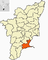
Ramanathapuram District
Encyclopedia
Ramanathapuram District is an administrative district of Tamil Nadu
state in southern India
. The city of Ramanathapuram
is the district headquarters. Ramanthapuram District has an area
of 4123 km². It is bounded on the north by Sivaganga District
, on the northeast by Pudukkottai District
, on the east by the Palk Strait
, on the south by the Gulf of Mannar
, on the west by Thoothukudi District
, and on the northwest by Virudhunagar District
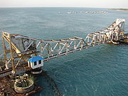
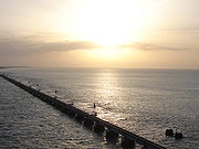
. The district contains the Pamban Bridge
, an east-west chain of low islands and shallow reefs that extend between India and the island nation of Sri Lanka
, and separate the Palk Strait from the Gulf of Mannar. The Palk Strait is presently navigable only by shallow-draft vessels.
of 11,87,604 (as of 2001). It is 25.46% urbanised. The district has a literacy of 73.05%, slightly below the average for the state. 78.15 % of the population are Hindus, 14.7% are Muslims and Christians constitute 7.08% of the district population. This district has the highest number of According to the 2011 census
Ramanathapuram district has a population
of 1,337,560, roughly equal to the nation of Mauritius
or the US state of Maine
. This gives it a ranking of 363rd in India (out of a total of 640
). The district has a population density of 320 PD/sqkm . Its population growth rate
over the decade 2001-2011 was 12.63 %. Ramanathapuram has a sex ratio
of 977 females
for every 1000 males, and a literacy rate
of 81.48 %.
Muslims (as a percentage of total population) in the state followed by Vellore District
. The religious composition of the district is 72.41% Hindus, 22.4% Muslims, Christians 5.08% and others 0.11%.
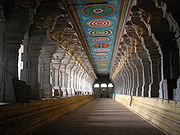 In the early 12th century, Syed Ibrahim Shaheed of Medinah defeated the then ruler Vikrama Pandiyan and captured the Bouthiramanikkapattinam province (Today's Ervadi and surrounding places), but 12 years later Jamara Kolagala Pandiyan, son of Thiruppandiyan, re-captured the Ramanathapuram throne through a treaty with Syed Ishaq (son of Syed Ismail the brother of Badusha Sulthan Syed Ibrahim Shaheed), who got Bouthiramanikkapattinam province. Both their heirs ruled their provinces until the late 16th century.
In the early 15th century, the present territories of Ramanathapuram district, comprising taluks Tiruvadanai, Paramakudi, Kamuthi, Mudukulathur, Ramanathapuram and Rameswaram, were included in the Pandyan Empire. For a short period, this area was under the Chola Kings when Rajendra Chola brought it under his territory in 1063 AD. In 1520 AD, the Nayaks of Vijayangar took over this area under their control from the Pandyan dynasty for about two centuries, Marava chieftains-Sethupathis who were Lords under Pandiyan Kings and reigned over this part (17th century). At the beginning of the 18th century, family disputes over succession resulted in the division of Ramanathapuram.
In 1795, the British deposed Muthuramalinga Sethupathy and took control of the administration of Ramanathapuram. In 1803 Mangaleswari Nachiyar was made the Zamindar of Sivagangai. After passing of Queen, the Marudhu Brothers took the charge by paying regular revenue to the East India company. In 1801 the Marudhu Brothers of Sivaganga revolted against the British in collaboration with Kattabomman of Panchalamkurichi. Colonel Agnew captured Marudhu Brothers and hanged them and made Gowri Vallbah Periya Udaya Thevar as Zamindar of Sivaganga. After the fall of Tipu Sultan
, British took the control and imprisoned the Nawab. In 1792 the Zamindari system was abolished and a British Collector was appointed for administration.
After the period of Sethupathis, in 1910, Ramanathapuram was formed by clubbing portions from Madurai and Tirunelveli district. This district was named Ramanathapuram. During the British period this district was called "Ramnad". The name remained after independence. Later the district was renamed to Ramanathapuram to be in conformity with the Tamil name for the region. Couple of years back Indian Archaeological Department found some ancient pottery in Theriruveli, 32 km away from Ramanathapuram.
Tamil Nadu
Tamil Nadu is one of the 28 states of India. Its capital and largest city is Chennai. Tamil Nadu lies in the southernmost part of the Indian Peninsula and is bordered by the union territory of Pondicherry, and the states of Kerala, Karnataka, and Andhra Pradesh...
state in southern India
India
India , officially the Republic of India , is a country in South Asia. It is the seventh-largest country by geographical area, the second-most populous country with over 1.2 billion people, and the most populous democracy in the world...
. The city of Ramanathapuram
Ramanathapuram
Ramanathapuram , also known as Ramnad, is a city and a municipality in Ramanathapuram district in the Indian state of Tamil Nadu. It is the administrative headquarters of Ramanathapuram district.-Tourism:...
is the district headquarters. Ramanthapuram District has an area
Area
Area is a quantity that expresses the extent of a two-dimensional surface or shape in the plane. Area can be understood as the amount of material with a given thickness that would be necessary to fashion a model of the shape, or the amount of paint necessary to cover the surface with a single coat...
of 4123 km². It is bounded on the north by Sivaganga District
Sivaganga District
Sivaganga District is an administrative district of Tamil Nadu state in southern India. The city of Sivaganga is the district headquarters. It is bounded by Pudukkottai district on the Northeast, Tiruchirapalli district on the North, Ramanathapuram district on South East, Virudhunagar district...
, on the northeast by Pudukkottai District
Pudukkottai District
Pudukkottai District is a district of Tamil Nadu state in southern India. The city of Pudukkottai is the district headquarters...
, on the east by the Palk Strait
Palk Strait
Palk Strait is a strait between the Tamil Nadu state of India and the Mannar district of the Northern Province of the island nation of Sri Lanka. It connects the Bay of Bengal in the northeast with the Palk Bay and thence with the Gulf of Mannar in the southwest. The strait is wide. Several...
, on the south by the Gulf of Mannar
Gulf of Mannar
The Gulf of Mannar is a large shallow bay forming part of the Laccadive Sea in the Indian Ocean. It lies between the southeastern tip of India and the west coast of Sri Lanka. A chain of low islands and reefs known as Adam's Bridge, also called Ramsethu, which includes Mannar Island, separates the...
, on the west by Thoothukudi District
Thoothukudi District
Thoothukudi District, also known as Tuticorin District, is a district of Tamil Nadu state in southern India. Thoothukudi is the district headquarters. It is also known for Pearl cultivation with abundance of pearls found in the seas of Thoothukudi...
, and on the northwest by Virudhunagar District
Virudhunagar District
Virudhunagar District is an administrative district of Tamil Nadu state in southern India. Virudhunagar is the district headquarters. Virudhunagar district was formed from parts of Tirunelveli and Madurai districts....
. The district contains the Pamban Bridge
Pamban Bridge
The Pamban Bridge is a cantilever bridge on the Palk Strait connects Rameswaram on Pamban Island to mainland India. It refers to both the road bridge and the cantilever railway bridge, though primarily it means the latter. It was India's first sea bridge...
, an east-west chain of low islands and shallow reefs that extend between India and the island nation of Sri Lanka
Sri Lanka
Sri Lanka, officially the Democratic Socialist Republic of Sri Lanka is a country off the southern coast of the Indian subcontinent. Known until 1972 as Ceylon , Sri Lanka is an island surrounded by the Indian Ocean, the Gulf of Mannar and the Palk Strait, and lies in the vicinity of India and the...
, and separate the Palk Strait from the Gulf of Mannar. The Palk Strait is presently navigable only by shallow-draft vessels.
Demographics
It had a populationPopulation
A population is all the organisms that both belong to the same group or species and live in the same geographical area. The area that is used to define a sexual population is such that inter-breeding is possible between any pair within the area and more probable than cross-breeding with individuals...
of 11,87,604 (as of 2001). It is 25.46% urbanised. The district has a literacy of 73.05%, slightly below the average for the state. 78.15 % of the population are Hindus, 14.7% are Muslims and Christians constitute 7.08% of the district population. This district has the highest number of According to the 2011 census
2011 census of India
The 15th Indian National census was conducted in two phases, houselisting and population enumeration. Houselisting phase began on April 1, 2010 and involved collection of information about all buildings...
Ramanathapuram district has a population
Demographics of India
The demographics of India are inclusive of the second most populous country in the world, with over 1.21 billion people , more than a sixth of the world's population. Already containing 17.5% of the world's population, India is projected to be the world's most populous country by 2025, surpassing...
of 1,337,560, roughly equal to the nation of Mauritius
Mauritius
Mauritius , officially the Republic of Mauritius is an island nation off the southeast coast of the African continent in the southwest Indian Ocean, about east of Madagascar...
or the US state of Maine
Maine
Maine is a state in the New England region of the northeastern United States, bordered by the Atlantic Ocean to the east and south, New Hampshire to the west, and the Canadian provinces of Quebec to the northwest and New Brunswick to the northeast. Maine is both the northernmost and easternmost...
. This gives it a ranking of 363rd in India (out of a total of 640
Districts of India
A district is an administrative division of an Indian state or territory. Districts are further subdivided, in some cases into Sub-Divisions, and otherwise directly into tehsils or talukas.District officials include:...
). The district has a population density of 320 PD/sqkm . Its population growth rate
Family planning in India
Family planning in India is based on efforts largely sponsored by the Indian government. In the 1965-2009 period, contraceptive usage has more than tripled and the fertility rate has more than halved , but the national fertility rate is still high enough to cause long-term population growth...
over the decade 2001-2011 was 12.63 %. Ramanathapuram has a sex ratio
Sex ratio
Sex ratio is the ratio of males to females in a population. The primary sex ratio is the ratio at the time of conception, secondary sex ratio is the ratio at time of birth, and tertiary sex ratio is the ratio of mature organisms....
of 977 females
Women in India
The status of women in India has been subject to many great changes over the past few millennia. From equal status with men in ancient times through the low points of the medieval period, to the promotion of equal rights by many reformers, the history of women in India has been eventful...
for every 1000 males, and a literacy rate
Literacy in India
Literacy in India is key for socio-economic progress, and the Indian literacy rate grew to 74.04% in 2011 from 12% at the end of British rule in 1947. Although this was a greater than sixfold improvement, the level is well below the world average literacy rate of 84%, and India currently has the...
of 81.48 %.
Muslims (as a percentage of total population) in the state followed by Vellore District
Vellore District
Vellore district is one of the 32 districts in the Tamil Nadu state of India. Vellore City is the headquarters of this district. It had a population of 3,477,317 as of 2001. It is 37.62% urbanised...
. The religious composition of the district is 72.41% Hindus, 22.4% Muslims, Christians 5.08% and others 0.11%.
History

In the early 15th century, the present territories of Ramanathapuram district, comprising taluks Tiruvadanai, Paramakudi, Kamuthi, Mudukulathur, Ramanathapuram and Rameswaram, were included in the Pandyan Empire. For a short period, this area was under the Chola Kings when Rajendra Chola brought it under his territory in 1063 AD. In 1520 AD, the Nayaks of Vijayangar took over this area under their control from the Pandyan dynasty for about two centuries, Marava chieftains-Sethupathis who were Lords under Pandiyan Kings and reigned over this part (17th century). At the beginning of the 18th century, family disputes over succession resulted in the division of Ramanathapuram.
In 1795, the British deposed Muthuramalinga Sethupathy and took control of the administration of Ramanathapuram. In 1803 Mangaleswari Nachiyar was made the Zamindar of Sivagangai. After passing of Queen, the Marudhu Brothers took the charge by paying regular revenue to the East India company. In 1801 the Marudhu Brothers of Sivaganga revolted against the British in collaboration with Kattabomman of Panchalamkurichi. Colonel Agnew captured Marudhu Brothers and hanged them and made Gowri Vallbah Periya Udaya Thevar as Zamindar of Sivaganga. After the fall of Tipu Sultan
Tipu Sultan
Tipu Sultan , also known as the Tiger of Mysore, was the de facto ruler of the Kingdom of Mysore. He was the son of Hyder Ali, at that time an officer in the Mysorean army, and his second wife, Fatima or Fakhr-un-Nissa...
, British took the control and imprisoned the Nawab. In 1792 the Zamindari system was abolished and a British Collector was appointed for administration.
After the period of Sethupathis, in 1910, Ramanathapuram was formed by clubbing portions from Madurai and Tirunelveli district. This district was named Ramanathapuram. During the British period this district was called "Ramnad". The name remained after independence. Later the district was renamed to Ramanathapuram to be in conformity with the Tamil name for the region. Couple of years back Indian Archaeological Department found some ancient pottery in Theriruveli, 32 km away from Ramanathapuram.
Tourism


- ErwadiErwadiErvadi or Erwadi is a village in Ramanathapuram district, Tamil Nadu in southern India belonging to Kadaladi Taluk and Keelakarai Town panchayat. The village is the location of the grave and shrine of Qutbus Sultan Syed Ibrahim Shaheed Badusha, the then ruler of Madinah Al Munawwara...
- SayalgudiSayalgudiSayalgudi is a panchayat town in Ramanathapuram district in the Indian state of Tamil Nadu.- Demographics : India census, Sayalgudi had a population of 12,049. Males constitute 50% of the population and females 50%. Sayalgudi has an average literacy rate of 68%, higher than the national average of...
- ParamakudiParamakudiParamakudi is a town, a municipality in Ramanathapuram district in the Indian state of Tamil Nadu. The river Vaigai flows through Paramakudi on its way to the Bay of Bengal.-Demographics and location:...
- KattupalliKattupalliKattupalli is a separate campus in Ervadi dargah, Ramanathapuram district where the graves of Thousands of Martyrs who came along with Badhusha Sultan Syed Ibraaheem Shaheed is found....
- ValinokkamValinokkamValinokkam is a village in Ramanathapuram district in Tamil Nadu where the Graves of Hazart Imraan Ummayah Al Badawiyyah shaheed raziyallah Ta'ala anhu and Hazrat Sulthan Abdul Qadir Raziyallah anhu along with numbers of shuhadaas who were martyred along with Badhusha Sulthan Syed Ibrahim Shaheed...
(Ummayyah Al Badawiyyah Imran Shahid Durgah & Salt Corporation) - SundaramudayanSundaramudayanSundaramudayan is a village near Uchipuli in Ramanathapuram district where the grave of Hazrat ILme Yaseen Shaheed Raziyallah ta'ala anhu well known as Seeniappa who came along with Badhusha Sulthan Syed Ibrahim Shaheed of Erwadi is found. The locality itself is called as Seeniappa Dargha and there...
(ILme Yaaseen - Seeniappa Shahid Durgah) - Meesal Kilavanery (Umar Qattab Shahid Mosque)
- Thachu ooraniThachu ooraniThachu oorani is a village locality near Erwadi dargah in Ramanathapuram district where the grave of Hazrat Syed Mursal Ibrahim Shaheed a descendant of Badhusha Sulthan Syed Ibrahim Shaheed and Father of Hazrat Nalla Ibrahim waliyullah razi is found....
(Mursal Ibrahim shaheedh Mosque) - PanaikulamPanaikulamPanaikulam or Panaikkulam is a big village located in the eastern part of Ramanathapuram district, Tamil Nadu, India. The inhabitants of this village are primarily Tamil Muslims.-History:and established a mosque for praying....
(Baba-Syed Muhammed Mosque) - AthiyuthuAthiyuthuAthiyuthu is a village located 9 km from the center of Ramanathapuram district, Tamil Nadu, India. It has some similar places nearby, such as Chittarkottai, Panaikulam, Pudhuvalasai Alagankulam and Aatrangarai.- Panchayat :...
(Jamiya Masjid & Pattani Shahib Durgah) - Regunathapuram (Kannan temple , Ayyapa temple - there are peaceful places)
- Bogalur (Masjid ul Muhammediya Mosque)
- Ramanathapuram Palace (This palace was built during the reign of Kizhavan Sethupathi (1674-1710 CE) the most popular among the Sethupathi Kings.)
Notable people
- A. P. J. Abdul Kalam, India's 11th President
- Kamal HaasanKamal HaasanKamal Haasan is an Indian film actor, screenwriter and director, considered to be one of the leading method actors of Indian cinema. He is widely acclaimed as an actor and is well known for his versatility in acting...
, Tamil cinema actor - Vikram Kennedy, Tamil cinema actor
- Senthil, Tamil cinema comedy actor
- Devipriya, Tamil cinema Serial actress
- Sakthimohan, Tamil cinema Short film Director

