
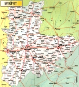
Akola District
Encyclopedia
Akola is a district in the India
n state
of Maharashtra
. The city of Akola
is the district headquarters. Akola district forms the central part of Amravati Division
, and was a former British Raj
Berar Province
.
Area of the district is 5,431 km². It is bounded on the north by Amravati District
, to the east by Amravati District
and by Washim District
, to the south by Washim District, and to the west by Buldhana District
. Washim was earlier a part of Akola.
, (Adgaon near Akot), took place on November 28, 1803, between the British
under the command of Governor Arthur Wellesley
and the forces of Maratha
under Bhonsle
of Nagpur
during Second Anglo-Maratha War
.
Many old forts are located in Akola District viz.
and longitude are : E
The climate is tropical and people mostly uses cotton clothes.
forms the part of north boundary of the district, and the top north portion of the district lies within its watershed along with Aas River and Shahnur River. The Vaan River
forms the part of northwest boundary of the district after entering from the Amravati district.
The Maan River drains the southwestern portion of the district, Morna River drains the midsouth portion of the district,while the southeast is drained by the Katepurna River and Uma River.
Here are some of the rivers in Akola
, with their tributaries
Akola district has a population
of 1,818,617, roughly equal to the nation of Kosovo
or the US state of Nebraska
. This gives it a ranking of 262nd in India (out of a total of 640
). The district has a population density of 321 PD/sqkm . Its population growth rate
over the decade 2001-2011 was 11.6 %. Akola has a sex ratio
of 942 females
for every 1000 males, and a literacy rate
of 87.55 %.
, an Indo-Aryan
language spoken by 100 000 people.
, Telhara
, Akola
, Balapur
, Patur
, Barshitakli
and Murtajapur
.
Junction (AK), Murtijapur Junction (MZR) and are under Bhusawal-Badnera Section of Bhusawal Railway Division
of Central Railway.
The other stations under meter gauge are Hiwarkhed, Adgaon Buzurg (ABZ), Akot (AKOT), Patsul (PTZ), Ugwe (UGWE), Akola
Junction, Shivani Shivpur (SVW), Barshitakli (BSQ), Lohogad (LHD), Amna Vadi (AMW), Jaulka (JUK) are under Purna - Khandwa Section of South Central Railway
.
The stations under narrow gauge are Lakhpuri, Murtajapur
Junction, Karanja under two Narrow Gauge Branch lines viz Murtajapur-Achalpur and Murtajapur-Yavatmal of Bhusawal Railway Division
of Central Railway.
and Jawar are the predominant crops grown in the district. Oil and Dal mills are also rampant. The economy is mostly agriculture based. Nowadays, soyabean crop is an important crop as major soyabean plants have come up in the area.
India
India , officially the Republic of India , is a country in South Asia. It is the seventh-largest country by geographical area, the second-most populous country with over 1.2 billion people, and the most populous democracy in the world...
n state
States and territories of India
India is a federal union of states comprising twenty-eight states and seven union territories. The states and territories are further subdivided into districts and so on.-List of states and territories:...
of Maharashtra
Maharashtra
Maharashtra is a state located in India. It is the second most populous after Uttar Pradesh and third largest state by area in India...
. The city of Akola
Akola
Akola is a city in the state of Maharashtra located in the Vidarbha region of central India. It is located around 600 km east of Mumbai and 250 km west of Nagpur. Akola is the headquarters of Akola District located in Amravati Division.Akola district has an area of about 54.31 square...
is the district headquarters. Akola district forms the central part of Amravati Division
Amravati Division
Amravati division is one of the six administrative divisions of Maharashtra state in India. Amravati and Nagpur divisions constitute the ancient Vidarbha region...
, and was a former British Raj
British Raj
British Raj was the British rule in the Indian subcontinent between 1858 and 1947; The term can also refer to the period of dominion...
Berar Province
Berar Province
Berar Province, known also as the Hyderabad Assigned Districts, was a province of British India. The province, formerly ruled by the Nizam of Hyderabad, was administered by the British after 1853, although the Nizam retained formal sovereignty over the province...
.
Area of the district is 5,431 km². It is bounded on the north by Amravati District
Amravati district
Amravati district is a district of Maharashtra state in central India. Amravati is the administrative headquarters of the district.The district is situated between 20°32' and 21°46' north latitudes and 76°37' and 78°27' east longitudes. The district occupies an area of 12,235 km²...
, to the east by Amravati District
Amravati district
Amravati district is a district of Maharashtra state in central India. Amravati is the administrative headquarters of the district.The district is situated between 20°32' and 21°46' north latitudes and 76°37' and 78°27' east longitudes. The district occupies an area of 12,235 km²...
and by Washim District
Washim district
Washim is a district in Maharashtra, India. The headquarters is at Washim. The area of the district is 5,150 km².-Demography and Geography:...
, to the south by Washim District, and to the west by Buldhana District
Buldhana district
-Buldhana district is a district in the Amravati division of Maharashtra state in western India. It is situated at the westernmost border of Vidarbha region of Maharashtra and is 500 km from the state capital, Mumbai...
. Washim was earlier a part of Akola.
History
The Battle of ArgaonAdgaon
Adgaon, known as Argaon during the period of the British Raj, is a village located in the Telhara tehsil near Akot in the Akola district of Maharashtra, India...
, (Adgaon near Akot), took place on November 28, 1803, between the British
United Kingdom
The United Kingdom of Great Britain and Northern IrelandIn the United Kingdom and Dependencies, other languages have been officially recognised as legitimate autochthonous languages under the European Charter for Regional or Minority Languages...
under the command of Governor Arthur Wellesley
Arthur Wellesley, 1st Duke of Wellington
Field Marshal Arthur Wellesley, 1st Duke of Wellington, KG, GCB, GCH, PC, FRS , was an Irish-born British soldier and statesman, and one of the leading military and political figures of the 19th century...
and the forces of Maratha
Maratha
The Maratha are an Indian caste, predominantly in the state of Maharashtra. The term Marāthā has three related usages: within the Marathi speaking region it describes the dominant Maratha caste; outside Maharashtra it can refer to the entire regional population of Marathi-speaking people;...
under Bhonsle
Bhonsle
The Bhonsle were a prominent clan within the Maratha clan system who served as rulers of several states in India.The most prominent member of the clan was Shivaji, the founder of the Maratha empire...
of Nagpur
Nagpur
Nāgpur is a city and winter capital of the state of Maharashtra, the largest city in central India and third largest city in Maharashtra after Mumbai and Pune...
during Second Anglo-Maratha War
Second Anglo-Maratha War
The Second Anglo-Maratha War was the second conflict between the British East India Company and the Maratha Empire in India.-Background:...
.
Many old forts are located in Akola District viz.
- Narnala Fort
- Akot Fort
- Akola FortAkola fortAkola fort along with the Narnala and Akot forts forms the major fortifications of the Akola district, Maharashtra, India.- History :...
- Balapur FortBalapur FortBalapur Fort is the fortress of Balapur which is in ruined condition now, was started by Mirza Azam Shah, die son of Emperor Aurangzeb and was completed by Ismail Khan, the Navab of Ellichpur in 1757 as per old gazetteer of berar indiaThe chhatri, a mausoleum constructed by Mirza Raja Jaysing is a...
Geography
The district boundary latitude are : Nand longitude are : E
The climate is tropical and people mostly uses cotton clothes.
Rivers and lakes
The Purna RiverPurna River
The Purna River is a river of Western India. It runs parallel to the Tapti river and empties in it at Changdev in Jalgaon, Maharashta.-Description:...
forms the part of north boundary of the district, and the top north portion of the district lies within its watershed along with Aas River and Shahnur River. The Vaan River
Vaan River
The Vaan River is a river of central India. It is tributary of Purna River, which is major tributary of Tapti River.-Description:It rises in the Gawilgarh hills of eastern Satpura Range in Amravati District of Maharashtra state, and flows southward, draining Amravati, Akola and Buldhana region...
forms the part of northwest boundary of the district after entering from the Amravati district.
The Maan River drains the southwestern portion of the district, Morna River drains the midsouth portion of the district,while the southeast is drained by the Katepurna River and Uma River.
Here are some of the rivers in Akola
Akola
Akola is a city in the state of Maharashtra located in the Vidarbha region of central India. It is located around 600 km east of Mumbai and 250 km west of Nagpur. Akola is the headquarters of Akola District located in Amravati Division.Akola district has an area of about 54.31 square...
, with their tributaries
Tributary
A tributary or affluent is a stream or river that flows into a main stem river or a lake. A tributary does not flow directly into a sea or ocean...
- Uma River
- Katepurna River
- Shahanur RiverShahanur riverShahanur is the river in Amravati and Akola districts in Vidarbha region of Maharashtra state in India. It is tributory of KatePurna river.- River Course :...
- Morna River
- Mann River
- Mas RiverMas RiverThe Kali Mas , is a distributary of the Brantas River in East Java, flowing north easterly towards the Madura Strait. This river also forms part of the border between Sidoarjo and Gresik regencies.-History:...
- Utawali River
- Vishwamitri RiverVishwamitri RiverThe Vishwamitri river is a seasonal river which flows east to west between the Mahi and Narmada rivers in Gujarat, India. It originates in the hills of Pavagadh....
- Nirguna River
- Gandhari River
- Mas River
- Aas River
- Vaan RiverVaan RiverThe Vaan River is a river of central India. It is tributary of Purna River, which is major tributary of Tapti River.-Description:It rises in the Gawilgarh hills of eastern Satpura Range in Amravati District of Maharashtra state, and flows southward, draining Amravati, Akola and Buldhana region...
Climate
Demographics
According to the 2011 census2011 census of India
The 15th Indian National census was conducted in two phases, houselisting and population enumeration. Houselisting phase began on April 1, 2010 and involved collection of information about all buildings...
Akola district has a population
Demographics of India
The demographics of India are inclusive of the second most populous country in the world, with over 1.21 billion people , more than a sixth of the world's population. Already containing 17.5% of the world's population, India is projected to be the world's most populous country by 2025, surpassing...
of 1,818,617, roughly equal to the nation of Kosovo
Kosovo
Kosovo is a region in southeastern Europe. Part of the Ottoman Empire for more than five centuries, later the Autonomous Province of Kosovo and Metohija within Serbia...
or the US state of Nebraska
Nebraska
Nebraska is a state on the Great Plains of the Midwestern United States. The state's capital is Lincoln and its largest city is Omaha, on the Missouri River....
. This gives it a ranking of 262nd in India (out of a total of 640
Districts of India
A district is an administrative division of an Indian state or territory. Districts are further subdivided, in some cases into Sub-Divisions, and otherwise directly into tehsils or talukas.District officials include:...
). The district has a population density of 321 PD/sqkm . Its population growth rate
Family planning in India
Family planning in India is based on efforts largely sponsored by the Indian government. In the 1965-2009 period, contraceptive usage has more than tripled and the fertility rate has more than halved , but the national fertility rate is still high enough to cause long-term population growth...
over the decade 2001-2011 was 11.6 %. Akola has a sex ratio
Sex ratio
Sex ratio is the ratio of males to females in a population. The primary sex ratio is the ratio at the time of conception, secondary sex ratio is the ratio at time of birth, and tertiary sex ratio is the ratio of mature organisms....
of 942 females
Women in India
The status of women in India has been subject to many great changes over the past few millennia. From equal status with men in ancient times through the low points of the medieval period, to the promotion of equal rights by many reformers, the history of women in India has been eventful...
for every 1000 males, and a literacy rate
Literacy in India
Literacy in India is key for socio-economic progress, and the Indian literacy rate grew to 74.04% in 2011 from 12% at the end of British rule in 1947. Although this was a greater than sixfold improvement, the level is well below the world average literacy rate of 84%, and India currently has the...
of 87.55 %.
Languages
Languages used in the district include AndhAndh language
The Andh language, also known as Andhi, is spoken by somewhere between 80,000 and 100,000 Andhs in India.The language is unclassified. Although these numbers sound substantial, it appears Andh may be losing ground with many Andhs speaking Marathi at home....
, an Indo-Aryan
Indo-Aryan languages
The Indo-Aryan languages constitutes a branch of the Indo-Iranian languages, itself a branch of the Indo-European language family...
language spoken by 100 000 people.
Subdivisions
Akola District consists of talukas namely AkotAkot
Akot is a city and a municipal council in Akola district in the Indian state of Maharashtra.-Prashis Meshram-Geography:Akot is located at . It has an average elevation of 345 metres .-Demographics:...
, Telhara
Telhara
Telhara.HISTORYTelhara.-Telhara is a town in the west of Akot taluk 17 miles from Akot. It is situated near to Satpuda parvat and having extreme climate conditions always. Town suffers too much cold in winter , too much rain and too much hot . It is situated near by "Gautama" river...
, Akola
Akola
Akola is a city in the state of Maharashtra located in the Vidarbha region of central India. It is located around 600 km east of Mumbai and 250 km west of Nagpur. Akola is the headquarters of Akola District located in Amravati Division.Akola district has an area of about 54.31 square...
, Balapur
Balapur
Balapur is a city and a municipal council in Akola district in the state of Maharashtra, India.The name Balapur is after the Village Goddess called Baladevi, the temple of which has a very ancient history.-Geography:Balapur is located at...
, Patur
Patur
Patur is a city and a municipal council in Akola district in the Indian state of Maharashtra.-Geography:Patur is located at . It has an average elevation of 341 metres .-Demographics:...
, Barshitakli
Barshitakli
Barshitakli is a town and a tehsil in Akola district in the Indian state of Maharashtra.-Geography:Barshitakli is located at . It has an average elevation of 310 metres ....
and Murtajapur
Murtajapur
Murtijapur is a municipal council and one of the taluka of district of Akola of Amravati division of Vidarbha region of Maharashtra.-Geography:...
.
Transport
Important railway stations with their codes are Paras, Gaigaon, AkolaAkola
Akola is a city in the state of Maharashtra located in the Vidarbha region of central India. It is located around 600 km east of Mumbai and 250 km west of Nagpur. Akola is the headquarters of Akola District located in Amravati Division.Akola district has an area of about 54.31 square...
Junction (AK), Murtijapur Junction (MZR) and are under Bhusawal-Badnera Section of Bhusawal Railway Division
Bhusawal railway division
Bhusawal railway division is one of the five railway division of Central Railway Zone of Indian Railways located at Bhusawal in Jalgaon district of Maharashtra state in western India. The other railway divisions are Mumbai CSTM, Nagpur, Solapur and Pune...
of Central Railway.
The other stations under meter gauge are Hiwarkhed, Adgaon Buzurg (ABZ), Akot (AKOT), Patsul (PTZ), Ugwe (UGWE), Akola
Akola
Akola is a city in the state of Maharashtra located in the Vidarbha region of central India. It is located around 600 km east of Mumbai and 250 km west of Nagpur. Akola is the headquarters of Akola District located in Amravati Division.Akola district has an area of about 54.31 square...
Junction, Shivani Shivpur (SVW), Barshitakli (BSQ), Lohogad (LHD), Amna Vadi (AMW), Jaulka (JUK) are under Purna - Khandwa Section of South Central Railway
South Central Railway
The South Central Railway is one of the 16 railway zones in India. It is headquartered at Secunderabad and has the following divisions:# Secunderabad# Hyderabad# Guntakal # Vijayawada# Guntur# Nanded...
.
The stations under narrow gauge are Lakhpuri, Murtajapur
Murtajapur
Murtijapur is a municipal council and one of the taluka of district of Akola of Amravati division of Vidarbha region of Maharashtra.-Geography:...
Junction, Karanja under two Narrow Gauge Branch lines viz Murtajapur-Achalpur and Murtajapur-Yavatmal of Bhusawal Railway Division
Bhusawal railway division
Bhusawal railway division is one of the five railway division of Central Railway Zone of Indian Railways located at Bhusawal in Jalgaon district of Maharashtra state in western India. The other railway divisions are Mumbai CSTM, Nagpur, Solapur and Pune...
of Central Railway.
Economy
CottonCotton
Cotton is a soft, fluffy staple fiber that grows in a boll, or protective capsule, around the seeds of cotton plants of the genus Gossypium. The fiber is almost pure cellulose. The botanical purpose of cotton fiber is to aid in seed dispersal....
and Jawar are the predominant crops grown in the district. Oil and Dal mills are also rampant. The economy is mostly agriculture based. Nowadays, soyabean crop is an important crop as major soyabean plants have come up in the area.