
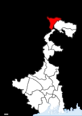
Darjeeling district
Encyclopedia
Darjeeling District is the northernmost district of the state of West Bengal
in eastern India
in the foothills of the Himalayas
. The district is famous for its beautiful hill station
s (and is often referred to as the Queen of the Hills) and Darjeeling tea
. Darjeeling is the district headquarters. Kalimpong, Kurseong
and Siliguri
, three other major towns in the district, are the subdivisional headquarters of the district. Mirik
, another town of the district, has been developed as a lake resort since the late 1970s.
Geographically, the district can be divided into two broad divisions, the hills and the plains. The entire hilly region of the district comes under the Darjeeling Gorkha Hill Council
, a semi-autonomous administrative body under the state government of West Bengal. The council covers the three hill subdivisions of Darjeeling, Kurseong and Kalimpong. The foothills of Darjeeling Himalayas, which comes under the Siliguri subdivision, is known as the Terai
. The Terai is bounded on the north by the mountains, on the south by Kishanganj district
of Bihar
state, on the east by Jalpaiguri district
and on the west by Nepal
. It has a length from north to south of 18 miles (29 km), and a breadth from east to west of 16 miles (25.7 km). As of 2011 it is the second least populous district of West Bengal (out of 19
), after Dakshin Dinajpur.
from Sikkim
. Prior to that, Darjeeling formed a part of Sikkim
and for a brief period of Nepal
.
Previously, Darjeeling formed a part of dominions of the Chogyal
of Sikkim, who had been engaged in an unsuccessful warfare against the Gorkha
s. From 1780, the Gorkhas made several attempts to capture the entire region of Darjeeling. By the beginning of 19th century, they had overrun Sikkim as far eastward as the Teesta River
and had conquered and annexed the Terai
.
In the meantime, the British were engaged in preventing the Gorkhas from overrunning the whole of the northern frontier. The Anglo-Gorkha
war broke out in 1814, which resulted in the defeat of the Gorkhas and subsequently led to the signing of the Sugauli Treaty
in 1815. According to the treaty, Nepal
had to cede all those territories which the Gorkhas had annexed from the Chogyal of Sikkim to the British East India Company (i.e. the area between Mechi River
and Teesta river).
Later in 1817, through the Treaty of Titalia
, the British East India Company
reinstated the Chogyal of Sikkim, restored all the tracts of land between the Mechi River and the Teesta river to the Chogyal of Sikkim and guaranteed his sovereignty.
The controversy did not end there. Later, in 1835, the hill of Darjeeling, including an enclave of 138 square miles (357.4 km²), was gifted to the British East India Company. In November 1864, the Treaty of Sinchula was executed in which the Bhutan Dooars with the passes leading into the hills and Kalimpong were ceded to the British by Bhutan
. The Darjeeling district can be said to have assumed its present shape and size in 1866 with an area of 1234 sq. miles.
 During the 1980s, the Gorkha National Liberation Front
led an intensive and often violent campaign for the creation of a separate Gorkhaland
state within India, across the Nepali
-speaking areas in northern West Bengal. The movement reached its peak around 1985-1986 but ended with the establishment of the Darjeeling Gorkha Hill Council in 1988.
Though Darjeeling is now peaceful, the issue of a separate state still lingers on, now supported by some political parties such as Gorkha Janmukti Morcha
.
The hill areas of Darjeeling enjoy some measure of autonomy under the Darjeeling Gorkha Hill Council
. However, the aspirations of the people of Darjeeling and the surrounding areas were not fulfilled and the demand for full statehood within India has emerged once again, with the Gorkha Janmukti Morcha as its chief proponent.
, Kalimpong
, Kurseong
and Siliguri
. Darjeeling is the district headquarter. There are 17 police stations, 12 community development blocks, 4 municipalities, 1 municipal corporation and 134 gram panchayat
s in this district.
Darjeeling and Kalimpong contain one municipality each and Kurseong has two. Siliguri has a municipal corporation instead. The community development blocks are divided into rural areas with gram panchayats. and census towns. In total there are 9 urban units: 4 municipalities, 1 municipal corporation and 4 census towns. Also, Darjeeling city and Pattabong Tea Garden
are part of a urban agglomeration.
Phansidewa constituency was reserved for Scheduled Tribes (ST) candidates. Along with two assembly constituencies from North Dinajpur district, the five assembly constituencies of this district formed the Darjeeling Lok Sabha constituency
.
Phansidewa constituency will continue to be reserved for Scheduled Tribes (ST) candidates. Matigara-Naxalbari constituency will be reserved for Scheduled Castes (SC) candidates. Along with one assembly constituency from North Dinajpur district, the six assembly constituencies of this district will form the Darjeeling Lok Sabha constituency
.
Darjeeling district has a population
of 1,842,034, roughly equal to the nation of Kosovo
or the US state of West Virginia
. This gives it a ranking of 257th in India (out of a total of 640
). The district has a population density of 585 PD/sqkm . Its population growth rate
over the decade 2001-2011 was 14.47 %. Darjiling has a sex ratio
of 971 females
for every 1000 males, and a literacy rate
of 79.92 %.
In 2001, the total population of the district was 1,609,172. The total rural population was 1,088,740 and total urban population was 520,432. Total males were 830,644 and total females were 778,528. The density of population was 511 per km2. The decennial population growth rate (1991–2001) was 23.79%.
The original inhabitants of the Darjeeling Hills were the Lepchas
or Rongpa (the ravine folks) as they prefer themselves to be known as. They are decidedly Mongolian in physical features. The greater bulk of the people in the hills today are the Gorkhas. They are industrious and enterprising as a race and speak Nepali
and various other dialects. Among the population are the Sherpas. They are well known for their contributions to mountaineering
. Also much in evidence in the hills are the Bhutias. There is also a sizable population of Tibetans who arrived from Tibet
since the 1950s. In the plains, one will find several communities like the Gorkhas, the adivasi
people originally from Chotanagpur
and Santhal Parganas
, and a greater bulk of Bengali
people.
language distantly related to Khmer
and Vietnamese
, spoken by about 25 000.
, which has an area of 88 square kilometre. It is also home to Singhalila National park
, which was established in 1986 and has an area of 79 square kilometre.
The district also contains three wildlife sanctuaries: Jorepokhri, Mahananda
, and Senchal.
West Bengal
West Bengal is a state in the eastern region of India and is the nation's fourth-most populous. It is also the seventh-most populous sub-national entity in the world, with over 91 million inhabitants. A major agricultural producer, West Bengal is the sixth-largest contributor to India's GDP...
in eastern India
India
India , officially the Republic of India , is a country in South Asia. It is the seventh-largest country by geographical area, the second-most populous country with over 1.2 billion people, and the most populous democracy in the world...
in the foothills of the Himalayas
Himalayas
The Himalaya Range or Himalaya Mountains Sanskrit: Devanagari: हिमालय, literally "abode of snow"), usually called the Himalayas or Himalaya for short, is a mountain range in Asia, separating the Indian subcontinent from the Tibetan Plateau...
. The district is famous for its beautiful hill station
Hill station
A hill station is a town located at a higher elevation than the nearby plain or valley. The term was used mostly in colonial Asia , but also in Africa , for towns founded by European colonial rulers as refuges from the summer heat, up where temperatures are cooler...
s (and is often referred to as the Queen of the Hills) and Darjeeling tea
Darjeeling tea
Darjeeling tea is a black tea from the Darjeeling region in West Bengal, India. When properly brewed, it yields a thin-bodied, light-colored infusion with a floral aroma...
. Darjeeling is the district headquarters. Kalimpong, Kurseong
Kurseong
Kurseong is a hill station situated in Darjeeling district of West Bengal, India.Located at an altitude of 1458 metres , Kurseong is just 30 km from Darjeeling...
and Siliguri
Siliguri
Siliguri is a city in the Indian state of West Bengal. It is located in the Siliguri Corridor or Chicken's Neck - a very narrow strip of land linking mainland India to its north-eastern states. It is also the transit point for air, road and rail traffic to the neighbouring countries of Nepal,...
, three other major towns in the district, are the subdivisional headquarters of the district. Mirik
Mirik
Mirik is a picturesque tourist spot nestled in the serene hills of Darjeeling district in West Bengal, India. The name Mirik comes from the Lepcha words Mir-Yok meaning "place burnt by fire"....
, another town of the district, has been developed as a lake resort since the late 1970s.
Geographically, the district can be divided into two broad divisions, the hills and the plains. The entire hilly region of the district comes under the Darjeeling Gorkha Hill Council
Darjeeling Gorkha Hill Council
Darjeeling Gorkha Hill Council , also once known for a short period of time as Darjeeling Gorkha Autonomous Hill Council , is a semi-autonomous body that looks after the administration of the Darjeeling District in the state of West Bengal, India...
, a semi-autonomous administrative body under the state government of West Bengal. The council covers the three hill subdivisions of Darjeeling, Kurseong and Kalimpong. The foothills of Darjeeling Himalayas, which comes under the Siliguri subdivision, is known as the Terai
Terai
The Terai is a belt of marshy grasslands, savannas, and forests located south of the outer foothills of the Himalaya, the Siwalik Hills, and north of the Indo-Gangetic Plain of the Ganges, Brahmaputra and their tributaries. The Terai belongs to the Terai-Duar savanna and grasslands ecoregion...
. The Terai is bounded on the north by the mountains, on the south by Kishanganj district
Kishanganj District
Kishanganj district is one of the thirty-eight districts of Bihar state, India, and Kishanganj town is the administrative headquarters of this district. Kishanganj district is a part of Purnia division.-History:...
of Bihar
Bihar
Bihar is a state in eastern India. It is the 12th largest state in terms of geographical size at and 3rd largest by population. Almost 58% of Biharis are below the age of 25, which is the highest proportion in India....
state, on the east by Jalpaiguri district
Jalpaiguri District
Jalpaiguri district is the largest district of North Bengal, covering an area 6,245 km2. It is situated between 26° 16' and 27° 0' North latitudes and 88° 4' and 89° 53' East longitudes...
and on the west by Nepal
Nepal
Nepal , officially the Federal Democratic Republic of Nepal, is a landlocked sovereign state located in South Asia. It is located in the Himalayas and bordered to the north by the People's Republic of China, and to the south, east, and west by the Republic of India...
. It has a length from north to south of 18 miles (29 km), and a breadth from east to west of 16 miles (25.7 km). As of 2011 it is the second least populous district of West Bengal (out of 19
Districts of West Bengal
The Indian state of West Bengal borders with Nepal, Bhutan, Bangladesh and the Indian states of Bihar, Jharkhand, Orissa, Assam and Sikkim. The Himalayas lies in the north of the state and the Bay of Bengal is at the south. In between them, the river Ganges flows eastwards and its main...
), after Dakshin Dinajpur.
History
The name Darjeeling comes from the Tibetan words, Dorje (thunderbolt) and Ling (place or land), meaning the land of the thunderbolt. In 1835, Darjeeling was annexed by the East India CompanyBritish East India Company
The East India Company was an early English joint-stock company that was formed initially for pursuing trade with the East Indies, but that ended up trading mainly with the Indian subcontinent and China...
from Sikkim
Sikkim
Sikkim is a landlocked Indian state nestled in the Himalayan mountains...
. Prior to that, Darjeeling formed a part of Sikkim
Sikkim
Sikkim is a landlocked Indian state nestled in the Himalayan mountains...
and for a brief period of Nepal
Nepal
Nepal , officially the Federal Democratic Republic of Nepal, is a landlocked sovereign state located in South Asia. It is located in the Himalayas and bordered to the north by the People's Republic of China, and to the south, east, and west by the Republic of India...
.
Previously, Darjeeling formed a part of dominions of the Chogyal
Chogyal
The Chogyal were the monarchs of the former kingdoms of Sikkim and Ladakh, which were ruled by separate branches of the Namgyal family. The Chogyal, or divine ruler, was the absolute potentate of Sikkim from 1642 to 1975, when its monarchy was abrogated and its people voted to make Sikkim India's...
of Sikkim, who had been engaged in an unsuccessful warfare against the Gorkha
Gurkha
Gurkha are people from Nepal who take their name from the Gorkha District. Gurkhas are best known for their history in the Indian Army's Gorkha regiments, the British Army's Brigade of Gurkhas and the Nepalese Army. Gurkha units are closely associated with the kukri, a forward-curving Nepalese knife...
s. From 1780, the Gorkhas made several attempts to capture the entire region of Darjeeling. By the beginning of 19th century, they had overrun Sikkim as far eastward as the Teesta River
Teesta River
River Teesta or Tista is said to be the lifeline of the Indian state of Sikkim, flowing for almost the entire length of the state and carving out verdant Himalayan temperate and tropical river valleys. The emerald-coloured river then forms the border between Sikkim and West Bengal before joining...
and had conquered and annexed the Terai
Terai
The Terai is a belt of marshy grasslands, savannas, and forests located south of the outer foothills of the Himalaya, the Siwalik Hills, and north of the Indo-Gangetic Plain of the Ganges, Brahmaputra and their tributaries. The Terai belongs to the Terai-Duar savanna and grasslands ecoregion...
.
In the meantime, the British were engaged in preventing the Gorkhas from overrunning the whole of the northern frontier. The Anglo-Gorkha
Gurkha War
The Gurkha War , sometimes called the Gorkha War or the Anglo–Nepalese War, was fought between the Kingdom of Nepal and the British East India Company as a result of border tensions and ambitious expansionism...
war broke out in 1814, which resulted in the defeat of the Gorkhas and subsequently led to the signing of the Sugauli Treaty
Sugauli Treaty
The Sugauli Treaty was signed on December 2, 1815 and ratified by March 4, 1816, between the British East India Company and Nepal, which was a kingdom during that era. This ended the second British invasion of the Himalayan kingdom during the Anglo-Nepalese War...
in 1815. According to the treaty, Nepal
Nepal
Nepal , officially the Federal Democratic Republic of Nepal, is a landlocked sovereign state located in South Asia. It is located in the Himalayas and bordered to the north by the People's Republic of China, and to the south, east, and west by the Republic of India...
had to cede all those territories which the Gorkhas had annexed from the Chogyal of Sikkim to the British East India Company (i.e. the area between Mechi River
Mechi River
The Mechi River is a trans-boundary river flowing through Nepal and India. It is a tributary of the Mahananda River.-Course:The Mechi originates in the Mahabharat Range in Nepal...
and Teesta river).
Later in 1817, through the Treaty of Titalia
Treaty of Titalia
The Treaty of Titalia was signed between the Chogyal of Sikkim and the British East India Company. The treaty, which was negotiated by Captain Barre Latter in February 1817, guaranteed security of Sikkim by the British and returned Sikkimese land annexed by the Nepalese over the centuries. It...
, the British East India Company
British East India Company
The East India Company was an early English joint-stock company that was formed initially for pursuing trade with the East Indies, but that ended up trading mainly with the Indian subcontinent and China...
reinstated the Chogyal of Sikkim, restored all the tracts of land between the Mechi River and the Teesta river to the Chogyal of Sikkim and guaranteed his sovereignty.
The controversy did not end there. Later, in 1835, the hill of Darjeeling, including an enclave of 138 square miles (357.4 km²), was gifted to the British East India Company. In November 1864, the Treaty of Sinchula was executed in which the Bhutan Dooars with the passes leading into the hills and Kalimpong were ceded to the British by Bhutan
Bhutan
Bhutan , officially the Kingdom of Bhutan, is a landlocked state in South Asia, located at the eastern end of the Himalayas and bordered to the south, east and west by the Republic of India and to the north by the People's Republic of China...
. The Darjeeling district can be said to have assumed its present shape and size in 1866 with an area of 1234 sq. miles.
Gorkhaland Movement
Gorkha National Liberation Front
Gorkha National Liberation Front is a political party in the Darjeeling District of West Bengal, India...
led an intensive and often violent campaign for the creation of a separate Gorkhaland
Gorkhaland
Gorkhaland is the name of the proposed state in India demanded by the Nepali/Gorkhali-speaking Nepali/Gorkha ethnic group in Darjeeling and the Dooars in north West Bengal....
state within India, across the Nepali
Nepali language
Nepali or Nepalese is a language in the Indo-Aryan branch of the Indo-European language family.It is the official language and de facto lingua franca of Nepal and is also spoken in Bhutan, parts of India and parts of Myanmar...
-speaking areas in northern West Bengal. The movement reached its peak around 1985-1986 but ended with the establishment of the Darjeeling Gorkha Hill Council in 1988.
Though Darjeeling is now peaceful, the issue of a separate state still lingers on, now supported by some political parties such as Gorkha Janmukti Morcha
Gorkha Janmukti Morcha
Gorkha Janmukti Morcha is a registered political party which campaigns for the creation of a separate state within India, out of districts in the north of West Bengal...
.
The hill areas of Darjeeling enjoy some measure of autonomy under the Darjeeling Gorkha Hill Council
Darjeeling Gorkha Hill Council
Darjeeling Gorkha Hill Council , also once known for a short period of time as Darjeeling Gorkha Autonomous Hill Council , is a semi-autonomous body that looks after the administration of the Darjeeling District in the state of West Bengal, India...
. However, the aspirations of the people of Darjeeling and the surrounding areas were not fulfilled and the demand for full statehood within India has emerged once again, with the Gorkha Janmukti Morcha as its chief proponent.
Geography
The Darjeeling hill area is formed of comparatively recent rock structure that has a direct bearing on landslides. However, heavy monsoon precipitation is however a very common cause of the landslides. Soils of Darjeeling hill areas are extremely varied, depending on elevation, degree of slope, vegetative cover and geolithology. The Himalayas serve as the source of natural resources for the population residing in the hillAdministrative subdivisions
The district comprises four subdivisions: Darjeeling SadarDarjeeling Sadar
Darjeeling Sadar subdivision is a subdivision of the Darjeeling district in the state of West Bengal, India. It consists of the Darjeeling municipality and three community development blocks: Darjeeling Pulbazar, Rangli Ranglot and Jorebunglow–Sukhiapokhri. The three blocks contain one...
, Kalimpong
Kalimpong subdivision
Kalimpong subdivision is a subdivision of the Darjeeling district in the state of West Bengal, India. It consists of the Kalimpong municipality and three community development blocks: Kalimpong–I, Kalimpong–II and Gorubathan. The three blocks contain 42 gram panchayats...
, Kurseong
Kurseong subdivision
Kurseong subdivision is a subdivision of the Darjeeling district in the state of West Bengal, India. It consists of the Kurseong municipality, Mirik municipality and two community development blocks: Mirik and Kurseong. The two blocks contain 20 gram panchayats...
and Siliguri
Siliguri subdivision
Siliguri subdivision is a subdivision of the Darjeeling district in the state of West Bengal, India. It consists of the Siliguri municipal corporation and four community development blocks: Matigara, Naxalbari, Phansidewa and Kharibari. The four blocks contain 22 gram panchayats and two census...
. Darjeeling is the district headquarter. There are 17 police stations, 12 community development blocks, 4 municipalities, 1 municipal corporation and 134 gram panchayat
Gram panchayat
Gram panchayats are local self-governments at the village or small town level in India. As of 2002 there were about 265,000 gram panchayats in India. The gram panchayat is the foundation of the Panchayat System. A gram panchayat can be set up in villages with minimum population of 300...
s in this district.
Darjeeling and Kalimpong contain one municipality each and Kurseong has two. Siliguri has a municipal corporation instead. The community development blocks are divided into rural areas with gram panchayats. and census towns. In total there are 9 urban units: 4 municipalities, 1 municipal corporation and 4 census towns. Also, Darjeeling city and Pattabong Tea Garden
Pattabong Tea Garden
Puttabong Tea Estate falls under the District of Darjeeling, West Bengal, India. Puttabong is a tea estate within the urban agglomeration of Darjeeling. The area under tea plantation is while the gross area is .-Demographics:...
are part of a urban agglomeration.
Darjeeling Sadar Subdivision
- Darjeeling municipality
- Darjeeling Pulbazar (Community development block)Darjeeling Pulbazar (Community development block)Darjeeling Pulbazar is an administrative division in Darjeeling Sadar subdivision of Darjeeling district in the Indian state of West Bengal. Lodhma, Darjeeling and Pulbazar police stations serve this block. Headquarters of this block is at Bijanbari...
consists of rural areas with 23 gram panchayats and one census town: Pattabong Tea GardenPattabong Tea GardenPuttabong Tea Estate falls under the District of Darjeeling, West Bengal, India. Puttabong is a tea estate within the urban agglomeration of Darjeeling. The area under tea plantation is while the gross area is .-Demographics:...
. - Rangli Rangliot (Community development block)Rangli Rangliot (Community development block)Rangli Rangliot is an administrative division in Darjeeling Sadar subdivision of Darjeeling district in the Indian state of West Bengal. Rangli Rangliot police station serves this block...
consists of rural areas only with 11 gram panchayats. - Jorebunglow Sukhiapokhri (Community development block)Jorebunglow Sukhiapokhri (Community development block)Jorebunglow Sukhiapokhri is an administrative division in Darjeeling Sadar subdivision of Darjeeling district in the Indian state of West Bengal. Jorebunglow and Sukhiapokhri police stations serve this block...
consists of rural areas only with 16 gram panchayats.
Kalimpong Subdivision
- Kalimpong municipality
- Kalimpong I (Community development block)Kalimpong I (Community development block)Kalimpong I is an administrative division in Kalimpong subdivision of Darjeeling district in the Indian state of West Bengal. Kalimpong police station serves this block...
consists of rural areas only with 18 gram panchayats. - Kalimpong II (Community development block)Kalimpong II (Community development block)Kalimpong II is an administrative division in Kalimpong subdivision of Darjeeling district in the Indian state of West Bengal. Kalimpong police station serves this block...
consists of rural areas only with 13 gram panchayats. - Gorubathan (Community development block)Gorubathan (Community development block)Gorubathan is an administrative division in Kalimpong subdivision of Darjeeling district in the Indian state of West Bengal. Gorubathan and Jaldhaka police stations serve this block...
consists of rural areas only with 11 gram panchayats.
Kurseong Subdivision
- KurseongKurseongKurseong is a hill station situated in Darjeeling district of West Bengal, India.Located at an altitude of 1458 metres , Kurseong is just 30 km from Darjeeling...
municipality - MirikMirikMirik is a picturesque tourist spot nestled in the serene hills of Darjeeling district in West Bengal, India. The name Mirik comes from the Lepcha words Mir-Yok meaning "place burnt by fire"....
municipality - Mirik (Community development block)Mirik (Community development block)Mirik is an administrative division in Kurseong subdivision of Darjeeling district in the Indian state of West Bengal. Mirik and Naxalbari police stations serve this block. Headquarters of this block is at Mirik....
consists of rural areas only with 6 gram panchayats. - Kurseong (Community development block)Kurseong (Community development block)Kurseong is an administrative division in Kurseong subdivision of Darjeeling district in the Indian state of West Bengal. Kurseong police station serves this block. Headquarters of this block is at Kurseong...
consists of rural areas with 14 gram panchayats and one census town: Cart RoadCart RoadCart Road is a census town in Darjeeling district in the state of West Bengal, India.-Demographics: India census, Cart Road had a population of 13,701. Males constitute 50% of the population and females 50%. Cart Road has an average literacy rate of 79%, higher than the national average of 59.5%;...
.
Siliguri Subdivision
- SiliguriSiliguriSiliguri is a city in the Indian state of West Bengal. It is located in the Siliguri Corridor or Chicken's Neck - a very narrow strip of land linking mainland India to its north-eastern states. It is also the transit point for air, road and rail traffic to the neighbouring countries of Nepal,...
municipal corporation - Matigara (Community development block) consists of rural areas with 5 gram panchayats and one census town: BairatisalBairatisalBairatisal is a census town in Darjeeling district in the state of West Bengal, India.-Demographics: India census, Bairatisal had a population of 5400. Males constitute 54% of the population and females 46%. Bairatisal has an average literacy rate of 82%, higher than the national average of 59.5%;...
. - Naxalbari (Community development block)Naxalbari (Community development block)Naxalbari is an administrative division in Siliguri subdivision of Darjeeling district in the Indian state of West Bengal. Naxalbari police station serves this block. Headquarters of this block is at Naxalbari. There is one census town in this block:Uttar Bagdogra,-Geography:Naxalbari is located at...
consists of rural areas with 6 gram panchayats and one census town: Uttar BagdograUttar BagdograUttar Bagdogra is a census town in Darjeeling district in the Indian state of West Bengal.-Demographics: India census, Uttar Bagdogra had a population of 15,772. Males constitute 52% of the population and females 48%. Uttar Bagdogra has an average literacy rate of 75%, higher than the national...
. - Phansidewa (Community development block) consists of rural areas only with 7 gram panchayats.
- Kharibari (Community development block)Kharibari (Community development block)Kharibari is an administrative division in Siliguri subdivision of Darjeeling district in the Indian state of West Bengal. Kharibari police station serves this block...
consists of rural areas only with 4 gram panchayats.
Assembly Constituencies
The district was previously divided into 5 assembly constituencies:- KalimpongKalimpong (Vidhan Sabha constituency)Kalimpong is an assembly constituency in Darjeeling district in the Indian state of West Bengal.-Extent:As per orders of the Delimitation Commission, No...
(assembly constituency no. 22), - DarjeelingDarjeeling (Vidhan Sabha constituency)Darjeeling is an assembly constituency in Darjeeling district in the Indian state of West Bengal.-Extent:As per orders of the Delimitation Commission, No...
(assembly constituency no. 23), - KurseongKurseong (Vidhan Sabha constituency)Kurseong is an assembly constituency in Darjeeling district in the Indian state of West Bengal.-Extent:As per orders of the Delimitation Commission, No...
(assembly constituency no. 24), - SiliguriSiliguri (Vidhan Sabha constituency)Siliguri is an assembly constituency in Darjeeling district in the Indian state of West Bengal.-Extent:As per orders of the Delimitation Commission, No. 26 Siliguri covers ward nos. 1 to 30 and 45 to 47 of Siliguri municipal corporation.Siliguri is part of No...
(assembly constituency no. 25) and - Phansidewa (ST)Phansidewa (Vidhan Sabha constituency)Phansidewa is an assembly constituency in Darjeeling district in the Indian state of West Bengal. The seat is reserved for scheduled tribes.-Extent:...
(assembly constituency no. 26).
Phansidewa constituency was reserved for Scheduled Tribes (ST) candidates. Along with two assembly constituencies from North Dinajpur district, the five assembly constituencies of this district formed the Darjeeling Lok Sabha constituency
Darjeeling (Lok Sabha Constituency)
Darjeeling Lok Sabha constituency is one of the 543 parliamentary constituencies in India. The constituency centres on Darjeeling in West Bengal.-Election results:-1951-1971:The winners are shown below. -1977-2004:-See also:...
.
Impact of Delimitation of Constituencies
As per order of the Delimitation Commission in respect of the delimitation of constituencies in West Bengal, the district will be divided into 6 assembly constituencies:- KalimpongKalimpong (Vidhan Sabha constituency)Kalimpong is an assembly constituency in Darjeeling district in the Indian state of West Bengal.-Extent:As per orders of the Delimitation Commission, No...
(assembly constituency no. 22), - DarjeelingDarjeeling (Vidhan Sabha constituency)Darjeeling is an assembly constituency in Darjeeling district in the Indian state of West Bengal.-Extent:As per orders of the Delimitation Commission, No...
(assembly constituency no. 23), - KurseongKurseong (Vidhan Sabha constituency)Kurseong is an assembly constituency in Darjeeling district in the Indian state of West Bengal.-Extent:As per orders of the Delimitation Commission, No...
(assembly constituency no. 24), - Matigara-Naxalbari (SC)Matigara-Naxalbari (Vidhan Sabha constituency)Matigara-Naxalbari is an assembly constituency in Darjeeling district in the Indian state of West Bengal. The seat is reserved for scheduled castes.-Extent:As per orders of the Delimitation Commission, No...
(assembly constituency no. 25), - SiliguriSiliguri (Vidhan Sabha constituency)Siliguri is an assembly constituency in Darjeeling district in the Indian state of West Bengal.-Extent:As per orders of the Delimitation Commission, No. 26 Siliguri covers ward nos. 1 to 30 and 45 to 47 of Siliguri municipal corporation.Siliguri is part of No...
(assembly constituency no. 26) and - Phansidewa (ST)Phansidewa (Vidhan Sabha constituency)Phansidewa is an assembly constituency in Darjeeling district in the Indian state of West Bengal. The seat is reserved for scheduled tribes.-Extent:...
(assembly constituency no. 27).
Phansidewa constituency will continue to be reserved for Scheduled Tribes (ST) candidates. Matigara-Naxalbari constituency will be reserved for Scheduled Castes (SC) candidates. Along with one assembly constituency from North Dinajpur district, the six assembly constituencies of this district will form the Darjeeling Lok Sabha constituency
Darjeeling (Lok Sabha Constituency)
Darjeeling Lok Sabha constituency is one of the 543 parliamentary constituencies in India. The constituency centres on Darjeeling in West Bengal.-Election results:-1951-1971:The winners are shown below. -1977-2004:-See also:...
.
Demographics
According to the 2011 census2011 census of India
The 15th Indian National census was conducted in two phases, houselisting and population enumeration. Houselisting phase began on April 1, 2010 and involved collection of information about all buildings...
Darjeeling district has a population
Demographics of India
The demographics of India are inclusive of the second most populous country in the world, with over 1.21 billion people , more than a sixth of the world's population. Already containing 17.5% of the world's population, India is projected to be the world's most populous country by 2025, surpassing...
of 1,842,034, roughly equal to the nation of Kosovo
Kosovo
Kosovo is a region in southeastern Europe. Part of the Ottoman Empire for more than five centuries, later the Autonomous Province of Kosovo and Metohija within Serbia...
or the US state of West Virginia
West Virginia
West Virginia is a state in the Appalachian and Southeastern regions of the United States, bordered by Virginia to the southeast, Kentucky to the southwest, Ohio to the northwest, Pennsylvania to the northeast and Maryland to the east...
. This gives it a ranking of 257th in India (out of a total of 640
Districts of India
A district is an administrative division of an Indian state or territory. Districts are further subdivided, in some cases into Sub-Divisions, and otherwise directly into tehsils or talukas.District officials include:...
). The district has a population density of 585 PD/sqkm . Its population growth rate
Family planning in India
Family planning in India is based on efforts largely sponsored by the Indian government. In the 1965-2009 period, contraceptive usage has more than tripled and the fertility rate has more than halved , but the national fertility rate is still high enough to cause long-term population growth...
over the decade 2001-2011 was 14.47 %. Darjiling has a sex ratio
Sex ratio
Sex ratio is the ratio of males to females in a population. The primary sex ratio is the ratio at the time of conception, secondary sex ratio is the ratio at time of birth, and tertiary sex ratio is the ratio of mature organisms....
of 971 females
Women in India
The status of women in India has been subject to many great changes over the past few millennia. From equal status with men in ancient times through the low points of the medieval period, to the promotion of equal rights by many reformers, the history of women in India has been eventful...
for every 1000 males, and a literacy rate
Literacy in India
Literacy in India is key for socio-economic progress, and the Indian literacy rate grew to 74.04% in 2011 from 12% at the end of British rule in 1947. Although this was a greater than sixfold improvement, the level is well below the world average literacy rate of 84%, and India currently has the...
of 79.92 %.
In 2001, the total population of the district was 1,609,172. The total rural population was 1,088,740 and total urban population was 520,432. Total males were 830,644 and total females were 778,528. The density of population was 511 per km2. The decennial population growth rate (1991–2001) was 23.79%.
The original inhabitants of the Darjeeling Hills were the Lepchas
Lepcha people
The Lepcha or Róng people , also called Róngkup , Mútuncí Róngkup Rumkup , and Rongpa , are the aboriginal people of Sikkim, who number between 30,000 and 50,000...
or Rongpa (the ravine folks) as they prefer themselves to be known as. They are decidedly Mongolian in physical features. The greater bulk of the people in the hills today are the Gorkhas. They are industrious and enterprising as a race and speak Nepali
Nepali language
Nepali or Nepalese is a language in the Indo-Aryan branch of the Indo-European language family.It is the official language and de facto lingua franca of Nepal and is also spoken in Bhutan, parts of India and parts of Myanmar...
and various other dialects. Among the population are the Sherpas. They are well known for their contributions to mountaineering
Mountaineering
Mountaineering or mountain climbing is the sport, hobby or profession of hiking, skiing, and climbing mountains. While mountaineering began as attempts to reach the highest point of unclimbed mountains it has branched into specialisations that address different aspects of the mountain and consists...
. Also much in evidence in the hills are the Bhutias. There is also a sizable population of Tibetans who arrived from Tibet
Tibet
Tibet is a plateau region in Asia, north-east of the Himalayas. It is the traditional homeland of the Tibetan people as well as some other ethnic groups such as Monpas, Qiang, and Lhobas, and is now also inhabited by considerable numbers of Han and Hui people...
since the 1950s. In the plains, one will find several communities like the Gorkhas, the adivasi
Adivasi
Adivasi is an umbrella term for a heterogeneous set of ethnic and tribal groups claimed to be the aboriginal population of India. They comprise a substantial indigenous minority of the population of India...
people originally from Chotanagpur
Chota Nagpur Plateau
The Chota Nagpur Plateau is a plateau in eastern India, which covers much of Jharkhand state as well as adjacent parts of Orissa, West Bengal, Bihar and Chhattisgarh. The Indo-Gangetic plain lies to the north and east of the plateau, and the basin of the Mahanadi River lies to the south...
and Santhal Parganas
Santhal Parganas
Santhal Pargana division constitutes one of the five administrative units known as the divisions of Jharkhand state in eastern India.-Origin of name:...
, and a greater bulk of Bengali
Bengali people
The Bengali people are an ethnic community native to the historic region of Bengal in South Asia. They speak Bengali , which is an Indo-Aryan language of the eastern Indian subcontinent, evolved from the Magadhi Prakrit and Sanskrit languages. In their native language, they are referred to as বাঙালী...
people.
Languages
Languages include Bijori, a MundaMunda languages
-Anderson :Gregory Anderson's 1999 proposal is as follows. Individual languages are highlighted in italics.*North Munda **Korku**Kherwarian***Santhali***Mundari*South Munda **Kharia–Juang***Juang***Kharia...
language distantly related to Khmer
Khmer language
Khmer , or Cambodian, is the language of the Khmer people and the official language of Cambodia. It is the second most widely spoken Austroasiatic language , with speakers in the tens of millions. Khmer has been considerably influenced by Sanskrit and Pali, especially in the royal and religious...
and Vietnamese
Vietnamese language
Vietnamese is the national and official language of Vietnam. It is the mother tongue of 86% of Vietnam's population, and of about three million overseas Vietnamese. It is also spoken as a second language by many ethnic minorities of Vietnam...
, spoken by about 25 000.
Flora and fauna
In 1986 Darjeeling district became home to Neora Valley National ParkNeora Valley National Park
Neora Valley National Park is situated in the Kalimpong subdivision under Darjeeling District, West Bengal, India and was established in 1986. It spreads over an area of 88 km² and is one of the richest biological zones in the entire Northeast...
, which has an area of 88 square kilometre. It is also home to Singhalila National park
National parks of India
This is a list of all national parks of India. India's first national park was established in 1936 as Hailey National Park, now known as Jim Corbett National Park. By 1970, India only had five national parks...
, which was established in 1986 and has an area of 79 square kilometre.
The district also contains three wildlife sanctuaries: Jorepokhri, Mahananda
Mahananda Wildlife Sanctuary
Mahananda Wildlife Sanctuary is located on the foothills of the Himalayas, between the Teesta and Mahananda rivers.-Location and History:Mahananda Wildlife Sanctuary is situated in the Darjeeling district of West Bengal, India. It comes under Darjeeling Wildlife division and can be reached from...
, and Senchal.
See also
- GorkhalandGorkhalandGorkhaland is the name of the proposed state in India demanded by the Nepali/Gorkhali-speaking Nepali/Gorkha ethnic group in Darjeeling and the Dooars in north West Bengal....
- GurkhaGurkhaGurkha are people from Nepal who take their name from the Gorkha District. Gurkhas are best known for their history in the Indian Army's Gorkha regiments, the British Army's Brigade of Gurkhas and the Nepalese Army. Gurkha units are closely associated with the kukri, a forward-curving Nepalese knife...
- Gorkha Janmukti MorchaGorkha Janmukti MorchaGorkha Janmukti Morcha is a registered political party which campaigns for the creation of a separate state within India, out of districts in the north of West Bengal...
- Gorkha National Liberation FrontGorkha National Liberation FrontGorkha National Liberation Front is a political party in the Darjeeling District of West Bengal, India...