

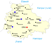
Jalaun District
Encyclopedia
Districts of Uttar Pradesh
The Indian state of Uttar Pradesh borders with Nepal and the Indian states of Bihar, Jharkhand, Chhattisgarh, Madhya Pradesh, Rajasthan, Haryana, Uttarakhand and National Capital Territory of Delhi. The Himalayas lies in the north of the state and the Deccan Plateau is at the south...
of Uttar Pradesh state
States and territories of India
India is a federal union of states comprising twenty-eight states and seven union territories. The states and territories are further subdivided into districts and so on.-List of states and territories:...
of India.
The district is named after town of Jalaun
Jalaun
Jalaun is a city and a municipal board in Jalaun district in the Indian state of Uttar Pradesh.The town was formerly the residence of a Maratha governor, but never the headquarters of the district, which are at Orai.-History:...
, which was the former headquarters of a Maratha
Maratha
The Maratha are an Indian caste, predominantly in the state of Maharashtra. The term Marāthā has three related usages: within the Marathi speaking region it describes the dominant Maratha caste; outside Maharashtra it can refer to the entire regional population of Marathi-speaking people;...
governor, but the administrative headquarters of the district is at Orai
Orai
Orai is a city and a municipal board in Jalaun district in the Indian state of Uttar Pradesh. It is the district headquarter for Jalaun District which is part of Jhansi division....
. Other large towns in the district are Kalpi
Kalpi
Kalpi is a city and a municipal board in Jalaun district in the Indian state of Uttar Pradesh. It is on the right bank of the Yamuna.-History:...
, Konch
Konch
Konch is a city and a municipal board in Jalaun district in the Indian state of Uttar Pradesh.- Geography :Konch is located at . It has an average elevation of 141 metres . Konch is a small town in district Jalaun of Uttar Pradesh...
, and Madhogarh
Madhogarh
Madhogarh is a town and a nagar panchayat in Jalaun district in the Indian state of Uttar Pradesh.-Demographics: India census, Madhogarh had a population of 50,071. Males constitute 54% of the population and females 46%. Madhogarh has an average literacy rate of 63%, higher than the national...
.
Geography
Jalaun District is a part of Jhansi DivisionJhansi Division
Jhansi Division is one of 17 divisions of Uttar Pradesh state in northern India. It includes Jhansi, Jalaun, and Lalitpur districts. The city of Jhansi is the administrative center. The division is part of the historic Bundelkhand region, which includes a portion of southern Uttar Pradesh and...
. The district has an area of 4565 km², and a population of 1,455,859 (2001 census), with a population density of 319 persons per km².
The district lies entirely within the level plain of Bundelkhand
Bundelkhand
Bundelkhand anciently known as Chedi Kingdom is a geographic region of central India...
, north of the hill country, and is almost surrounded by the Yamuna River, which forms the northern boundary of the district, and its tributaries the Betwa
Betwa River
The Betwa is a river in Northern India, and a tributary of the Yamuna. Also known as the Vetravati, the Betwa rises in the Vindhya Range just north of Hoshangabad in Madhya Pradesh and flows north-east through Madhya Pradesh and flow through Orchha to Uttar Pradesh. Nearly one-half of its course,...
, which forms the southern boundary of the district, and the Pahuj
Pahuj River
Pahuj River is a river flowing in Bhind District of Madhya Pradesh in central India.It is tributary of Sindh River, which joins Yamuna River in Etawah Uttar Pradesh state, just after the Chambal River confluences into Yamuna river....
, which forms the western boundary. The central region thus enclosed is a dead level of cultivated land, almost destitute of trees, and dotted with villages. The southern portion presents an almost unbroken sheet of cultivation. The Non River flows through the centre of the district, which it drains by innumerable small ravines.
The districts of Etawah
Etawah District
Etawah district is a district in the southwestern portion of Uttar Pradesh state of India. Etawah town is the district headquarters. Etawah district is part of Kanpur Division. The district covers an area of 2311 km²...
and Kanpur
Kanpur District
Kanpur district is one of the districts of the Uttar Pradesh state of India. It is a part of Kanpur division and its district headquarters is Kanpur. Due to increase in population of Kanpur District, for proper administration it has been divided into two. The term Kanpur refers to the combination...
lie to the north across the Yamuna, while Hamirpur District
Hamirpur District, Uttar Pradesh
Hamirpur district is one of the 70 districts of Uttar Pradesh state of India and Hamirpur town is the district headquarters. Hamirpur district is a part of Chitrakoot Division. The district occupies an area of 4,121.9 km². The district has a population of 1,042,374...
lies to the east and southeast, Jhansi District
Jhansi District
Jhansi District is one of the districts of Uttar Pradesh state in northern India. The town of Jhansi is the district headquarters.The district is bordered on the north by Jalaun District, to the east by Hamirpur and Mahoba districts, to the south by Tikamgarh District of Madhya Pradesh state, to...
lies to the southeast, and Bhind District
Bhind District
Bhind District is a district of Madhya Pradesh state in central India of Chambal region. The town of Bhind is the district headquarter....
of Madhya Pradesh
Madhya Pradesh
Madhya Pradesh , often called the Heart of India, is a state in central India. Its capital is Bhopal and Indore is the largest city....
lies to the west cross the Pahuj.
The district has been under severe drought for the last four years with the average rainfall being about 399 mm which is way behind the average of about 800 mm.
Economy
In 2006 the Ministry of Panchayati RajMinistry of Panchayati Raj
The Ministry of Panchayati Raj is a branch of the Government of India looking after the ongoing process of decentralization and local governance in the States....
named Jalaun one of the country's 250 most backward districts
Poverty in India
Poverty is widespread in India, with the nation estimated to have a third of the world's poor. According to a 2005 World Bank estimate, 41.6% of the total Indian population falls below the international poverty line of 1.25 a day...
(out of a total of 640
Districts of India
A district is an administrative division of an Indian state or territory. Districts are further subdivided, in some cases into Sub-Divisions, and otherwise directly into tehsils or talukas.District officials include:...
). It is one of the 34 districts in Uttar Pradesh currently receiving funds from the Backward Regions Grant Fund Programme (BRGF).
Demographics
According to the 2011 census2011 census of India
The 15th Indian National census was conducted in two phases, houselisting and population enumeration. Houselisting phase began on April 1, 2010 and involved collection of information about all buildings...
has a population
Demographics of India
The demographics of India are inclusive of the second most populous country in the world, with over 1.21 billion people , more than a sixth of the world's population. Already containing 17.5% of the world's population, India is projected to be the world's most populous country by 2025, surpassing...
of 1,670,718 , roughly equal to the nation of Guinea-Bissau
Guinea-Bissau
The Republic of Guinea-Bissau is a country in West Africa. It is bordered by Senegal to the north, and Guinea to the south and east, with the Atlantic Ocean to its west....
or the US state of Idaho
Idaho
Idaho is a state in the Rocky Mountain area of the United States. The state's largest city and capital is Boise. Residents are called "Idahoans". Idaho was admitted to the Union on July 3, 1890, as the 43rd state....
. This gives it a ranking of 296th in India (out of a total of 640
Districts of India
A district is an administrative division of an Indian state or territory. Districts are further subdivided, in some cases into Sub-Divisions, and otherwise directly into tehsils or talukas.District officials include:...
).
The district has a population density of 366 PD/sqkm . Its population growth rate
Family planning in India
Family planning in India is based on efforts largely sponsored by the Indian government. In the 1965-2009 period, contraceptive usage has more than tripled and the fertility rate has more than halved , but the national fertility rate is still high enough to cause long-term population growth...
over the decade 2001-2011 was 14.87 %. Jalaun has a sex ratio
Sex ratio
Sex ratio is the ratio of males to females in a population. The primary sex ratio is the ratio at the time of conception, secondary sex ratio is the ratio at time of birth, and tertiary sex ratio is the ratio of mature organisms....
of 865 females
Women in India
The status of women in India has been subject to many great changes over the past few millennia. From equal status with men in ancient times through the low points of the medieval period, to the promotion of equal rights by many reformers, the history of women in India has been eventful...
for every 1000 males, and a literacy rate
Literacy in India
Literacy in India is key for socio-economic progress, and the Indian literacy rate grew to 74.04% in 2011 from 12% at the end of British rule in 1947. Although this was a greater than sixfold improvement, the level is well below the world average literacy rate of 84%, and India currently has the...
of 75.16 %.