
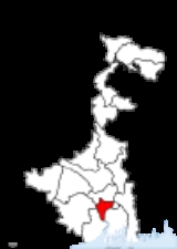
Howrah District
Encyclopedia
Howrah district is a district of the West Bengal
state in eastern India
. It has thousands of years of rich heritage in the form of the great Bengali kingdom of Bhurshut
. The district is named after its headquarters, the city of Howrah.
sub-division). On the west Howrah district is bordered by the Ghatal sub-division of Midnapore West district, and partly by the Arambagh sub-division of Hooghly district to the north-west, and the Tamluk sub-division of Midnapore East district to the south-west.
Boundaries of the district are naturally determined by Rupnarayan River
on west and south-west, and by Bhagirathi-Hooghly river on east and south-east side. On north side, the boundary is an artificial one except for Bally Canal on north-east and Damodar River
on north-west.
Annual normal rainfall is 1461 milimeter per year. Annual maximum temperature varies between 32-39°C, whereas minimum temperature varies between 8-10°C.
municipality and Howrah municipal corporation and five community development blocks (CD blocks): Bally–Jagacha, Domjur, Panchla, Sankrail and Jagatballavpur. Uluberia subdivision consists of Uluberia
Municipality and nine CD blocks: Uluberia–I, Uluberia–II, Amta–I, Amta–II, Udaynarayanpur, Bagnan–I, Bagnan–II, Shyampur–I and Shyampur–II.
Howrah district has 1 municipal corporation in Howrah, 2 municipalities in Bally
and Uluberia
. Rest of the area under this district is divided in 14 community development blocks. Each block consists of rural area divided into gram panchayat
s along with urban units like census towns. This district has 11 police stations, 157 gram panchayats, and 50 census towns. Khalisani in Uluberia - II block and Chak Srikrishna in Sankrail block were noted as urban outgrowths in census 2001.
Sankrail and Uluberia North constituencies are reserved for Scheduled Castes (SC) candidates. Bally, Howrah North, Howrah Central, Howrah South, Shibpur, Domjur and Sankrail constituencies form the Howrah (Lok Sabha constituency)
. Uluberia North, Uluberia South, Shyampur, Bagnan, Kalyanpur, Amta and Udaynarayanpur constituencies form the Uluberia (Lok Sabha constituency)
. Along with five assembly constituencies from Hooghly district
, Jagatballavpur and Panchla constituencies form the Serampore (Lok Sabha constituency)
.
Sankrail and Uluberia North constituencies will remain reserved for Scheduled Castes (SC) candidates. Bally, Howrah North, Howrah Central, Shibpur, Howrah South, Sankrail and Panchla constituencies will form the Howrah (Lok Sabha constituency)
. Uluberia East, Uluberia North, Uluberia South, Shyampur, Bagnan, Amta and Udaynarayanpur constituencies will form the Uluberia (Lok Sabha constituency)
. Along with five assembly constituencies from Hooghly district
, Jagatballavpur and Domjur constituencies will form the Sreerampur (Lok Sabha constituency).
Howrah district has a population
of 4,841,638, roughly equal to the nation of Singapore
or the US state of Alabama
. This gives it a ranking of 23rd in India (out of a total of 640
). The district has a population density of 3300 PD/sqkm . Its population growth rate
over the decade 2001-2011 was 13.31 %. Haora has a sex ratio
of 935 females
for every 1000 males, and a literacy rate
of 83.85 %.
Total area in Howrah District is 1467 km2. Total population is 4,273,099 as per census 2001 records. 57.91% of the population live in Howrah Sadar subdivision and rest 42.09% live in Uluberia subdivision. Population Density: 2913 per km2.
West Bengal
West Bengal is a state in the eastern region of India and is the nation's fourth-most populous. It is also the seventh-most populous sub-national entity in the world, with over 91 million inhabitants. A major agricultural producer, West Bengal is the sixth-largest contributor to India's GDP...
state in eastern India
India
India , officially the Republic of India , is a country in South Asia. It is the seventh-largest country by geographical area, the second-most populous country with over 1.2 billion people, and the most populous democracy in the world...
. It has thousands of years of rich heritage in the form of the great Bengali kingdom of Bhurshut
Bhurshut
Bhurshut was an ancient and medieval kingdom spread across what are now Howrah and Hooghly districts in the Indian state of West Bengal.Bhurshut kingdom grew up in the southern parts of Rarh region. It had a high concentration of Bhurisresthis, a community of traders and as such came to be called...
. The district is named after its headquarters, the city of Howrah.
Geography
The Howrah district lies between 22°48′ N and 22°12′ N latitudes and between 88°23′ E and 87°50′ E longitudes. The district is bounded by the Hooghly River and the North 24 Parganas and South 24 Parganas districts on the east, on the north by the Hooghly district (Arambagh and Shrirampur sub-divisions), and on the south by Midnapore East district (TamlukTamluk
Tamluk is the district headquarters of Purba Medinipur district of West Bengal, India. Though there is some controversy, scholars have generally agreed that present day Tamluk is the site of the ancient city variously known as Tamralipta or Tamralipti...
sub-division). On the west Howrah district is bordered by the Ghatal sub-division of Midnapore West district, and partly by the Arambagh sub-division of Hooghly district to the north-west, and the Tamluk sub-division of Midnapore East district to the south-west.
Boundaries of the district are naturally determined by Rupnarayan River
Rupnarayan River
The Rupnarayan River is a river in India. It begins as the Dhaleswari in the Chhota Nagpur plateau foothills northeast of the town of Purulia. It then follows a tortuous southeasterly course past the town of Bankura, where it is known as the Dwarakeswar river. Near the town of Ghatal it is...
on west and south-west, and by Bhagirathi-Hooghly river on east and south-east side. On north side, the boundary is an artificial one except for Bally Canal on north-east and Damodar River
Damodar River
Damodar River originates near Chandwa village, Palamau district, on the Chota Nagpur Plateau in the Jharkhand state in eastern India, and flows eastward for about 592 km through the states of Jharkhand and West Bengal to the estaury of the River Hooghly...
on north-west.
Annual normal rainfall is 1461 milimeter per year. Annual maximum temperature varies between 32-39°C, whereas minimum temperature varies between 8-10°C.
Administrative subdivisions
Howrah district has two subdivisions: Howrah Sadar and Uluberia. Howrah Sadar consists of BallyBally, Howrah
Bally is a city, municipality in Howrah District, West Bengal, India. It is a part of the area covered by Kolkata Metropolitan Development Authority. It is a town of historical importance...
municipality and Howrah municipal corporation and five community development blocks (CD blocks): Bally–Jagacha, Domjur, Panchla, Sankrail and Jagatballavpur. Uluberia subdivision consists of Uluberia
Uluberia
Uluberia is a city and a municipality in Howrah district in the Indian state of West Bengal. It is a part of the area covered by Kolkata Metropolitan Development Authority.-Geography:...
Municipality and nine CD blocks: Uluberia–I, Uluberia–II, Amta–I, Amta–II, Udaynarayanpur, Bagnan–I, Bagnan–II, Shyampur–I and Shyampur–II.
Howrah district has 1 municipal corporation in Howrah, 2 municipalities in Bally
Bally, Howrah
Bally is a city, municipality in Howrah District, West Bengal, India. It is a part of the area covered by Kolkata Metropolitan Development Authority. It is a town of historical importance...
and Uluberia
Uluberia
Uluberia is a city and a municipality in Howrah district in the Indian state of West Bengal. It is a part of the area covered by Kolkata Metropolitan Development Authority.-Geography:...
. Rest of the area under this district is divided in 14 community development blocks. Each block consists of rural area divided into gram panchayat
Gram panchayat
Gram panchayats are local self-governments at the village or small town level in India. As of 2002 there were about 265,000 gram panchayats in India. The gram panchayat is the foundation of the Panchayat System. A gram panchayat can be set up in villages with minimum population of 300...
s along with urban units like census towns. This district has 11 police stations, 157 gram panchayats, and 50 census towns. Khalisani in Uluberia - II block and Chak Srikrishna in Sankrail block were noted as urban outgrowths in census 2001.
Howrah Sadar subdivision
- Howrah: municipal corporation
- BallyBally, HowrahBally is a city, municipality in Howrah District, West Bengal, India. It is a part of the area covered by Kolkata Metropolitan Development Authority. It is a town of historical importance...
: municipality - Bally–Jagacha CD block consists of rural area with 8 gram panchayats and six census towns: Bally (different from Bally municipality), ChakaparaChakaparaChakapara is a census town under Liluah police station in Sadar subdivision of Howrah district in the Indian state of West Bengal.-Geography:Chakapara is located at . It has an average elevation of 14 metres .-Demographics:...
, ChamrailChamrailChamrail is a census town under Liluah police station in Sadar subdivision of Howrah district in the Indian state of West Bengal.-Demographics: India census, Chamrail had a population of 8554. Males constitute 51% of the population and females 49%...
, EksaraEksaraEksara is a census town under Liluah police station in Sadar subdivision of Howrah district in the Indian state of West Bengal.-Demographics:...
, KhaliaKhaliaKhalia is a census town under Liluah police station in Sadar subdivision of Howrah district in the Indian state of West Bengal.-Demographics:...
and JagadishpurJagadishpurJagadishpur is a census town under Liluah police station in Sadar subdivision of Howrah district in the Indian state of West Bengal.-Demographics: India census, Jagadishpur had a population of 12,826. Males constitute 51% of the population and females 49%...
Durgapur-Avoynagar1,Durgapur-Avoynagar2, Nischinda. - Domjur CD block consists of rural area with 18 gram panchayats and sixteen census towns: DomjurDomjurDomjur is a census town in Sadar subdivision of Howrah district in the Indian state of West Bengal.-Geography:Domjur is located at . It has an average elevation of 11 metres .-Demographics:...
, Dakshin JhapardahaDakshin JhapardahaDakshin Jhapardaha is a census town under Domjur police station in Sadar subdivision of Howrah district in the state of West Bengal, India.-Geography:Dakshin Jhapardaha is located at -Demographics:...
, KhantoraKhantoraKhantora is a census town under Domjur police station in Sadar subdivision of Howrah district in the Indian state of West Bengal.-Geography:Khantora is located at -Demographics:...
, BhandardahaBhandardahaBhandardaha is a census town under Domjur police station in Sadar subdivision of Howrah district in the state of West Bengal, India.-Geography:Bhandardaha is located at . It has an average elevation of 12 metres .-Demographics:...
, MakardahaMakardahaMakardaha is a census town under Domjur police station in Sadar subdivision of Howrah district in the Indian state of West Bengal.-Geography:Makardaha is located at .Saraswati River used to flow past the village.-Demographics:...
, KantliaKantliaKantlia is a census town under Domjur police station in Sadar subdivision of Howrah district in the Indian state of West Bengal.-Geography:Kantlia is located at -Demographics:...
, TentulkuliTentulkuliTentulkuli is a census town under Domjur police station in Sadar subdivision of Howrah district in the Indian state of West Bengal.-Demographics: India census, Tentulkuli had a population of 5122. Males constitute 51% of the population and females 49%...
, SalapSalapSalap is a census town under Domjur police station in Sadar subdivision of Howrah district in the Indian state of West Bengal.-Demographics:...
, BankraBankraBankra is a census town under Domjur police station in Sadar subdivision of Howrah district in the Indian state of West Bengal.-Geography:Bankra is located at . It has an average elevation of 8 metres .-Demographics:...
, NibraNibraNibra is a census town under Domjur police station in Sadar subdivision of Howrah district in the Indian state of West Bengal.-Geography:Nibra is located at . It has an average elevation of .-Demographics:...
, AnkurhatiAnkurhatiAnkurhati is a census town under Domjur police station in Sadar subdivision of Howrah district in the Indian state of West Bengal.-Demographics: India census, Ankurhati had a population of 7787. Males constitute 53% of the population and females 47%...
, Bipra NoaparaBipra NoaparaBipra Noapara is a census town under Domjur police station in Sadar subdivision of Howrah district in the Indian state of West Bengal.-Geography:Bipra Noapara is located at -Demographics:...
, KalaraKalaraKalara is a census town under Domjur police station in Sadar subdivision of Howrah district in the Indian state of West Bengal.-Demographics:...
, Kesabpur, NatibpurNatibpurNatibpur is a census town under Domjur police station in Sadar subdivision of Howrah district in the Indian state of West Bengal.-Geography:Natibpur is located at -Demographics:...
, and MahiariMahiariMahiari is a census town under Domjur police station in Sadar subdivision of Howrah district in the Indian state of West Bengal.-Geography:Mahiari is located at...
. - Panchla CD block consists of rural area with 11 gram panchayats and seven census towns: BikihakolaBikihakolaBikihakola is a census town under Panchla police station in Sadar subdivision of Howrah district in the state of West Bengal, India.-Geography:Bikihakola is located at -Demographics:...
, BeldubiBeldubiBeldubi is a census town under Panchla police station in Sadar subdivision of Howrah district in the state of West Bengal, India.-Geography:Beldubi is located at -Demographics:...
, Jala KenduaJala KenduaJala Kendua is a census town under Panchla police station in Sadar subdivision of Howrah district in the Indian state of West Bengal.-Demographics: India census, Jala Kendua had a population of 5783. Males constitute 49% of the population and females 51%...
, GabberiaGabberiaGabberia is a census town under Panchla police station in Sadar subdivision of Howrah district in the state of West Bengal, India.-Demographics: India census, Gabberia had a population of 4974. Males constitute 51% of the population and females 49%...
, PaniaraPaniaraPaniara is a census town under Panchla police station in Sadar subdivision of Howrah district in the Indian state of West Bengal.-Geography:Paniara is located at -Demographics:...
, PanchlaPanchlaPanchla is a census town and police station in Sadar subdivision of Howrah district in the Indian state of West Bengal.-Geography:Panchla is located at . It has an average elevation of 7 metres .-Demographics:...
and SahapurSahapurSahapur is a census town under Panchla police station in Sadar subdivision of Howrah district in the Indian state of West Bengal.-Geography:Sahapur is located at...
. - Sankrail CD block consists of rural area with 16 gram panchayats and fourteen census towns: ArgariArgariArgari is a census town under Sankrail police station in Sadar subdivision of Howrah district in the Indian state of West Bengal.-Demographics:...
, DhuilyaDhuilyaDhuilya is a census town under Sankrail police station in Sadar subdivision of Howrah district in the Indian state of West Bengal.-Geography:Dhuilya is located at -Demographics:...
, AndulAndulAndul is a census town in Sankrail block under sadar sub-division in Howrah district in the Indian state of West Bengal. It is a local hub of commercial and industrial activity within and around Sankrail block.-History:...
, Ramchandrapur, PodaraPodaraPodara is a census town under Sankrail police station in Sadar subdivision of Howrah district in the Indian state of West Bengal.-Geography:Podrah is located at -Demographics:...
, PanchparaPanchparaPanchpara is a census town under Sankrail police station in Sadar subdivision of Howrah district in the Indian state of West Bengal.-Geography:Panchpara is located at -Demographics:...
, HatgachhaHatgachhaHatgachha is a census town in Howrah district in the Indian state of West Bengal.-Geography:Hatgachha is located at -Demographics: India census, Hatgachha had a population of 5560. Males constitute 53% of the population and females 47%. Hatgachha has an average literacy rate of 80%, higher than...
, JhorhatJhorhatJhorhat is a census town under Sankrail police station in Sadar subdivision of Howrah district in the Indian state of West Bengal.-Demographics: India census, Jhorhat had a population of 16,123. Males constitute 54% of the population and females 46%...
, BanupurBanupurBanupur is a census town under Sankrail police station in Sadar subdivision of Howrah district in the Indian state of West Bengal.-Demographics: India census, Banupur had a population of 11,645. Males constitute 63% of the population and females 37%...
, SankrailSankrailSankrail is a census town in Sadar subdivision of Howrah district in the Indian state of West Bengal.-Geography:Sankrail is located at . It has an average elevation of 2 metres .-Demographics:...
, Manikpur, Nalpur, RaghudebbatiRaghudebbatiRaghudebbati is a census town under Sankrail police station in Sadar subdivision of Howrah district in the Indian state of West Bengal.-Geography:Raghudebbati is located at . It has an average elevation of 8 metres .-Demographics:...
and SarengaSarengaSarenga is a census town under Sankrail police station in Sadar subdivision of Howrah district in the Indian state of West Bengal.-Geography:Sarenga is located at . It has an average elevation of .-Demographics:...
. - Jagatballavpur CD block consists of rural area with 14 gram panchayats and one census town: MansinhapurMansinhapurMansinhapur is a census town under Jagatballavpur police station in Sadar subdivision of Howrah district in the Indian state of West Bengal.-History:...
.
Uluberia subdivision
- UluberiaUluberiaUluberia is a city and a municipality in Howrah district in the Indian state of West Bengal. It is a part of the area covered by Kolkata Metropolitan Development Authority.-Geography:...
: municipality - Amta–IAmtaAmta I is an administrative division in Uluberia subdivision of Howrah district in the Indian state of West Bengal. Amta police station serves this block...
CD block consists of rural area only with 13 gram panchayats. - Amta–IIAmtaAmta I is an administrative division in Uluberia subdivision of Howrah district in the Indian state of West Bengal. Amta police station serves this block...
CD block consists of rural area only with 14 gram panchayats. - Bagnan–IBagnanBagnan is a census town in Howrah district in the state of West Bengal, in eastern India. It has one of the busiest railway stations in South Eastern Railway Zone within West Bengal.-Geography:...
CD block consists of rural area with 10 gram panchayats and two census towns: KhalorKhalorKhalor is a census town in Howrah district in the Indian state of West Bengal.-Demographics: India census, Khalor had a population of 8669. Males constitute 51% of the population and females 49%. Khalor has an average literacy rate of 83%, higher than the national average of 59.5%: male literacy is...
and BagnanBagnanBagnan is a census town in Howrah district in the state of West Bengal, in eastern India. It has one of the busiest railway stations in South Eastern Railway Zone within West Bengal.-Geography:...
. - Bagnan–IIBagnanBagnan is a census town in Howrah district in the state of West Bengal, in eastern India. It has one of the busiest railway stations in South Eastern Railway Zone within West Bengal.-Geography:...
CD block consists of rural area with 7 gram panchayats and one census town: NaupalaNaupalaNaupala is a census town under Bagnan police station in Uluberia subdivision of Howrah district in the Indian state of West Bengal.-Geography:Naupala is located at . It lies on the right bank of the Rupnarayan River.-Demographics:...
. - Uluberia–I CD block consists of rural area only with 9 gram panchayats.The most important village is Bar-Mongrajpur under Hatgacha-1 G.P.
- Uluberia–II CD block consists of rural area with 8 gram panchayats and three census towns: SantoshpurSantoshpur, UluberiaSantoshpur is a census town under Uluberia police station in Howrah district in the Indian state of West Bengal.-Demographics: India census, Santoshpur had a population of 7,181. Males constitute 52% of the population and females 48%. Santoshpur has an average literacy rate of 74%, higher than the...
, Balaram PotaBalaram PotaBalaram Pota is a census town under Uluberia police station in Uluberia subdivision of Howrah district in the Indian state of West Bengal.-Geography:Balaram pota is located at -Demographics:...
and Uttar PirpurUttar PirpurUttar Pirpur is a census town under Uluberia police station in Uluberia subdivision of Howrah district in the Indian state of West Bengal.-Demographics:... - Shyampur–I CD block consists of rural area only with 10 gram panchayats.
- Shyampur–II CD block consists of rural area only with 8 gram panchayats.
- Udaynarayanpur CD block consists of rural area only with 11 gram panchayats.
Assembly constituencies
The district is divided into 16 assembly constituencies:- BallyBally (Vidhan Sabha constituency)Bally is an assembly constituency in Howrah district in the Indian state of West Bengal.-Extent:As per orders of the Delimitation Commission, No. 169 Bally is composed of the following: Bally municipality.Bally is part of No...
(assembly constituency no. 161), - Howrah NorthHowrah Uttar (Vidhan Sabha constituency)Howrah Uttar is an assembly constituency in Howrah district in the Indian state of West Bengal.-Extent:...
(assembly constituency no. 162), - Howrah CentralHowrah Madhya (Vidhan Sabha constituency)Howrah Madhya is an assembly constituency in Howrah district in the Indian state of West Bengal.-Extent:...
(assembly constituency no. 163), - Howrah SouthHowrah Dakshin (Vidhan Sabha constituency)Howrah Dakshin is an assembly constituency in Howrah district in the Indian state of West Bengal.-Extent:...
(assembly constituency no. 164), - ShibpurShibpur (Vidhan Sabha constituency)Shibpur is an assembly constituency in Howrah district in the Indian state of West Bengal.-Extent:As per orders of the Delimitation Commission, No. 172 Shibpur is composed of the following: Ward Nos. 8, 9, 21 to 23, 43 and 47 to 50 of Howrah municipal corporation.Shibpur is part of No...
(assembly constituency no. 165), - DomjurDomjur (Vidhan Sabha constituency)-1977-2006:In the 2006 state assembly elections Mohanta Chatterjee of CPI won the Domjur seat defeating his nearest rival Rajib Banerjee of Trinamool Congress. Contests in most years were multi cornered but only winners and runners are being mentioned...
(assembly constituency no. 166), - JagatballavpurJagatballavpur (Vidhan Sabha constituency)Jagatballavpur is an assembly constituency in Howrah district in the Indian state of West Bengal.-Extent:As per orders of the Delimitation Commission, No...
(assembly constituency no. 167), - PanchlaPanchla (Vidhan Sabha constituency)Panchla is an assembly constituency in Howrah district in the Indian state of West Bengal.-Extent:As per orders of the Delimitation Commission, No...
(assembly constituency no. 168), - Sankrail (SC)Sankrail (Vidhan Sabha constituency)Sankrail is an assembly constituency in Howrah district in the Indian state of West Bengal. The seat is reserved for scheduled castes.-Extent:As per orders of the Delimitation Commission, No...
(assembly constituency no. 169), - Uluberia North (SC)Uluberia Uttar (Vidhan Sabha constituency)Uluberia Uttar is an assembly constituency in Howrah district in the Indian state of West Bengal. The seat is reserved for scheduled castes.-Extent:As per orders of the Delimitation Commission, No...
(assembly constituency no. 170), - Uluberia SouthUluberia Dakshin (Vidhan Sabha constituency)Uluberia Dakshin is an assembly constituency in Howrah district in the Indian state of West Bengal.-Extent:As per orders of the Delimitation Commission, No...
(assembly constituency no. 171), - ShyampurShyampur (Vidhan Sabha constituency)Shyampur is an assembly constituency in Howrah district in the Indian state of West Bengal.-Extent:As per orders of the Delimitation Commission, No...
(assembly constituency no. 172), - BagnanBagnan (Vidhan Sabha constituency)Bagnan is an assembly constituency in Howrah district in the Indian state of West Bengal.-Extent:As per orders of the Delimitation Commission, No...
(assembly constituency no. 173), - Kalyanpur (assembly constituency no. 174),
- AmtaAmta (Vidhan Sabha constituency)Amta is an assembly constituency in Howrah district in the Indian state of West Bengal.-Extent:As per orders of the Delimitation Commission, No...
(assembly constituency no. 175) and - UdaynarayanpurUdaynarayanpur (Vidhan Sabha constituency)Udaynarayanpur is an assembly constituency in Howrah district in the Indian state of West Bengal.-Extent:As per orders of the Delimitation Commission, No...
(assembly constituency no. 176).
Sankrail and Uluberia North constituencies are reserved for Scheduled Castes (SC) candidates. Bally, Howrah North, Howrah Central, Howrah South, Shibpur, Domjur and Sankrail constituencies form the Howrah (Lok Sabha constituency)
Howrah (Lok Sabha constituency)
Howrah is one of the 543 parliamentary constituencies in India. The constituency centres on Howrah in West Bengal.-Assembly segments:...
. Uluberia North, Uluberia South, Shyampur, Bagnan, Kalyanpur, Amta and Udaynarayanpur constituencies form the Uluberia (Lok Sabha constituency)
Uluberia (Lok Sabha constituency)
Uluberia is one of the 543 parliamentary constituencies in India. The constituency centres on Uluberia in West Bengal.-Assembly segments:...
. Along with five assembly constituencies from Hooghly district
Hooghly District
Hooghly district is one of the districts of the state of West Bengal in India. It can alternatively be spelt Hoogli or Hugli. The district is named after the Hooghly River.The headquarters of the district are at Chinsura...
, Jagatballavpur and Panchla constituencies form the Serampore (Lok Sabha constituency)
Serampore (Lok Sabha constituency)
Serampore is one of the 543 parliamentary constituencies in India. The constituency centres on Serampore in West Bengal.-Election results:Results of elections held prior to 2009 are summarised below:-Assembly segments:...
.
Impact of delimitation of constituencies
As per order of the Delimitation Commission in respect of the delimitation of constituencies in the West Bengal, the district will be divided into 16 assembly constituencies:- BallyBally (Vidhan Sabha constituency)Bally is an assembly constituency in Howrah district in the Indian state of West Bengal.-Extent:As per orders of the Delimitation Commission, No. 169 Bally is composed of the following: Bally municipality.Bally is part of No...
(assembly constituency no. 169), - Howrah UttarHowrah Uttar (Vidhan Sabha constituency)Howrah Uttar is an assembly constituency in Howrah district in the Indian state of West Bengal.-Extent:...
(assembly constituency no. 170), - Howrah MadhyaHowrah Madhya (Vidhan Sabha constituency)Howrah Madhya is an assembly constituency in Howrah district in the Indian state of West Bengal.-Extent:...
(assembly constituency no. 171), - ShibpurShibpur (Vidhan Sabha constituency)Shibpur is an assembly constituency in Howrah district in the Indian state of West Bengal.-Extent:As per orders of the Delimitation Commission, No. 172 Shibpur is composed of the following: Ward Nos. 8, 9, 21 to 23, 43 and 47 to 50 of Howrah municipal corporation.Shibpur is part of No...
(assembly constituency no. 172), - Howrah DakshinHowrah Dakshin (Vidhan Sabha constituency)Howrah Dakshin is an assembly constituency in Howrah district in the Indian state of West Bengal.-Extent:...
(assembly constituency no. 173), - Sankrail (SC)Sankrail (Vidhan Sabha constituency)Sankrail is an assembly constituency in Howrah district in the Indian state of West Bengal. The seat is reserved for scheduled castes.-Extent:As per orders of the Delimitation Commission, No...
(assembly constituency no. 174), - PanchlaPanchla (Vidhan Sabha constituency)Panchla is an assembly constituency in Howrah district in the Indian state of West Bengal.-Extent:As per orders of the Delimitation Commission, No...
(assembly constituency no. 175), - Uluberia PurbaUluberia Purba (Vidhan Sabha constituency)Uluberia Purba is an assembly constituency in Howrah district in the Indian state of West Bengal. As a consequence of the orders of the Delimitation Commission, while Uluberia Purba comes in to existence in 2011, Kalyanpur ceases to exist from the same year.-Extent:As per orders of the...
(assembly constituency no. 176), - Uluberia Uttar (SC)Uluberia Uttar (Vidhan Sabha constituency)Uluberia Uttar is an assembly constituency in Howrah district in the Indian state of West Bengal. The seat is reserved for scheduled castes.-Extent:As per orders of the Delimitation Commission, No...
(assembly constituency no. 177), - Uluberia DakshinUluberia Dakshin (Vidhan Sabha constituency)Uluberia Dakshin is an assembly constituency in Howrah district in the Indian state of West Bengal.-Extent:As per orders of the Delimitation Commission, No...
(assembly constituency no. 178), - ShyampurShyampur (Vidhan Sabha constituency)Shyampur is an assembly constituency in Howrah district in the Indian state of West Bengal.-Extent:As per orders of the Delimitation Commission, No...
(assembly constituency no. 179), - BagnanBagnan (Vidhan Sabha constituency)Bagnan is an assembly constituency in Howrah district in the Indian state of West Bengal.-Extent:As per orders of the Delimitation Commission, No...
(assembly constituency no. 180), - AmtaAmta (Vidhan Sabha constituency)Amta is an assembly constituency in Howrah district in the Indian state of West Bengal.-Extent:As per orders of the Delimitation Commission, No...
(assembly constituency no. 181), - UdaynarayanpurUdaynarayanpur (Vidhan Sabha constituency)Udaynarayanpur is an assembly constituency in Howrah district in the Indian state of West Bengal.-Extent:As per orders of the Delimitation Commission, No...
(assembly constituency no. 182), - JagatballavpurJagatballavpur (Vidhan Sabha constituency)Jagatballavpur is an assembly constituency in Howrah district in the Indian state of West Bengal.-Extent:As per orders of the Delimitation Commission, No...
(assembly constituency no. 183) and - DomjurDomjur (Vidhan Sabha constituency)-1977-2006:In the 2006 state assembly elections Mohanta Chatterjee of CPI won the Domjur seat defeating his nearest rival Rajib Banerjee of Trinamool Congress. Contests in most years were multi cornered but only winners and runners are being mentioned...
(assembly constituency no. 184).
Sankrail and Uluberia North constituencies will remain reserved for Scheduled Castes (SC) candidates. Bally, Howrah North, Howrah Central, Shibpur, Howrah South, Sankrail and Panchla constituencies will form the Howrah (Lok Sabha constituency)
Howrah (Lok Sabha constituency)
Howrah is one of the 543 parliamentary constituencies in India. The constituency centres on Howrah in West Bengal.-Assembly segments:...
. Uluberia East, Uluberia North, Uluberia South, Shyampur, Bagnan, Amta and Udaynarayanpur constituencies will form the Uluberia (Lok Sabha constituency)
Uluberia (Lok Sabha constituency)
Uluberia is one of the 543 parliamentary constituencies in India. The constituency centres on Uluberia in West Bengal.-Assembly segments:...
. Along with five assembly constituencies from Hooghly district
Hooghly District
Hooghly district is one of the districts of the state of West Bengal in India. It can alternatively be spelt Hoogli or Hugli. The district is named after the Hooghly River.The headquarters of the district are at Chinsura...
, Jagatballavpur and Domjur constituencies will form the Sreerampur (Lok Sabha constituency).
Demographics
According to the 2011 census2011 census of India
The 15th Indian National census was conducted in two phases, houselisting and population enumeration. Houselisting phase began on April 1, 2010 and involved collection of information about all buildings...
Howrah district has a population
Demographics of India
The demographics of India are inclusive of the second most populous country in the world, with over 1.21 billion people , more than a sixth of the world's population. Already containing 17.5% of the world's population, India is projected to be the world's most populous country by 2025, surpassing...
of 4,841,638, roughly equal to the nation of Singapore
Singapore
Singapore , officially the Republic of Singapore, is a Southeast Asian city-state off the southern tip of the Malay Peninsula, north of the equator. An island country made up of 63 islands, it is separated from Malaysia by the Straits of Johor to its north and from Indonesia's Riau Islands by the...
or the US state of Alabama
Alabama
Alabama is a state located in the southeastern region of the United States. It is bordered by Tennessee to the north, Georgia to the east, Florida and the Gulf of Mexico to the south, and Mississippi to the west. Alabama ranks 30th in total land area and ranks second in the size of its inland...
. This gives it a ranking of 23rd in India (out of a total of 640
Districts of India
A district is an administrative division of an Indian state or territory. Districts are further subdivided, in some cases into Sub-Divisions, and otherwise directly into tehsils or talukas.District officials include:...
). The district has a population density of 3300 PD/sqkm . Its population growth rate
Family planning in India
Family planning in India is based on efforts largely sponsored by the Indian government. In the 1965-2009 period, contraceptive usage has more than tripled and the fertility rate has more than halved , but the national fertility rate is still high enough to cause long-term population growth...
over the decade 2001-2011 was 13.31 %. Haora has a sex ratio
Sex ratio
Sex ratio is the ratio of males to females in a population. The primary sex ratio is the ratio at the time of conception, secondary sex ratio is the ratio at time of birth, and tertiary sex ratio is the ratio of mature organisms....
of 935 females
Women in India
The status of women in India has been subject to many great changes over the past few millennia. From equal status with men in ancient times through the low points of the medieval period, to the promotion of equal rights by many reformers, the history of women in India has been eventful...
for every 1000 males, and a literacy rate
Literacy in India
Literacy in India is key for socio-economic progress, and the Indian literacy rate grew to 74.04% in 2011 from 12% at the end of British rule in 1947. Although this was a greater than sixfold improvement, the level is well below the world average literacy rate of 84%, and India currently has the...
of 83.85 %.
Total area in Howrah District is 1467 km2. Total population is 4,273,099 as per census 2001 records. 57.91% of the population live in Howrah Sadar subdivision and rest 42.09% live in Uluberia subdivision. Population Density: 2913 per km2.