
Satara
Encyclopedia
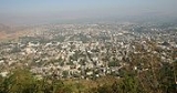
Satara is a city
located in the Satara District
of Maharashtra
state
of India
. The town is 2320 ft. above sea-level, near the confluence of the Krishna
and its tributary river Venna. The city was the capital of the Maratha empire in the 17th century, hence one of the the historical cities of Maharashtra. This city is the capital of Satara Tehsil, as well as Satara District.
and Tara (तारा) meaning hill, thus forming the word 'Satara'. Historians agree that the name of the city has its origins in the seven hills overlooking the city. The seven hills are Ajinkyatara, Sajjangad, Yawateshwar, Jarandeshwar, Nakdicha Dongar, Kitlicha Dongar, and Pedhyacha Bhairoba.
The empire of Chandragupta II
, known as Mahendraditya Kumargupta I, extended as far as Satara district in Deccan when he ruled between 451 AD to 455 AD. The Mauryan empire in the Deccan was followed by the rules of Satavahans for about two centuries between 550 A.D. to 750 AD.
's son Muhammad Azam Shah conquered Satara fort (Ajinkyatara) after a 6month siege. later won by Parshuram Pratinidhi in 1706. In 1708 Chattrapati Shahu,the son of Chhatrapati Sambhaji, was crowned on the Satara fort. The direct descendents of Raja Shivaji continue to live in Satara. The current king of Satara, Udayanraje Bhonsale is the 13th descendent of Shivaji Maharaj.
in 1818, the British Empire
annexed most of the Maratha territory to Bombay Presidency, but restored the titular Raja Pratap Singh, and assigned to him the principality of Satara, an area much larger than the present district. As a result of political intrigues, he was deposed in 1839, and his brother Shahji Raja was placed on the throne. This prince died without any male heirs,and as a result Satara was eventually annexed by the British government, and added to Bombay Presidency.
During the independence struggle,a type of Parallel Government known as Prati Sarkar came into existence.The people of Satara,under the leadership of Krantisinha Nana Patil,ousted the British officials and took power into their hands. During Quit India Movement
of 1942, this parallel government replaced British government for 4.5 years from August 1943 to May 1946. Similar ousters of British power in other areas,led to the formation of similar Parallel Governments in Midnapore in West Bengal and Purnia
in Uttar Pradesh. Such was the efficiency and power of these Parallel Governments that for nearly 4.5 years, the British did not even try to capture these areas, fearing defeat;which shows the popular nature of these governments.
Satara is located in the western part of Maharashtra
. Satara district is bounded by Pune
district to the north, Solapur
district to the east, Sangli district to the south and Ratnagiri district to the west. Raigad
district lies to its north-west. Satara District has an area of 10,480 km², and a population of 2,796,906 (2001).
The Sahyadri range, separates the district from Ratnagiri
on the western side
The black rock Mahadeo range starts about 10 m north of Mahabaleshwar
and stretches east and south-east across the whole of the district
The main rivers of Satara district are Koyna and Krishna. The Krishna is one of the three largest sacred rivers of southern India. Approximately 172 km of the river course falls inside the district. The Krishna river begins on the eastern brow of the Mahabaleshwar plateau and the source is about 4500 ft. above sea level. Kudali, Urmodi, Venna and Tarali are small feeder rivers (tributaries) of Krishna. Koyna is the largest tributary of the Krishna in the district. These two rivers met each other in Karad. There is formed a famous place called "Pritisangam" . Neera and Manganga rivers are the two representative of the Bhima drainage in the north and north-eastern parts of the district respectively.
. The temperature of Satara City is varies in the range 39°C-45°C in Summer and 5°C-20°C in winter. Due to Monsoon
, we can experience the rainy season between the period June to early October. In this area, near about 1000 mm rainfall occurs during monsoon.
The best time period to visit Satara City is between September to March.
Kaas Plateau is really a Valley of Flowers. You can enjoy the scene of widespread carpet of flowers, of different species (including some exclusive and rare species), colors and variety. spread over acres of land on the Kas platue. The lateritic plateau of Kass has becomes home to millions of tiny flowers in late monsoons. More than 300 varieties of wild flowers, herbs, orchids, shrubs, insectivorous plants etc. can be seen here in the time span form August to November (Best time is 15th Aug to 15th Oct). This plateau overlooks the lush evergreen forests that serves as a water catchment area of Koyna Dam
, Chandoli National Park
and Koyna Wildlife Sanctuary
was recently declared as “Sahyadri Tiger reserve". In monsoon the whole area transforms into an unbelievable carpets of flowers like yellow carpets of Smithia and Sonki flowers, Pink carpets of Balsam, Purple carpets of Karvi etc….
It is a dream destination not only for avid botanists but also for those who appreciate nature. These carpets change colours almost every week depending on the dominant flowers during that time.
, Satara had a population of 108,043. Males constitute 52% of the population and females 48%. Satara has an average literacy rate of 80%, higher than the national average of 74%: male literacy is 84%, and female literacy is 76%. In Satara, 10% of the population is under 6 years of age.
City
A city is a relatively large and permanent settlement. Although there is no agreement on how a city is distinguished from a town within general English language meanings, many cities have a particular administrative, legal, or historical status based on local law.For example, in the U.S...
located in the Satara District
Satara district
Satara District is a district of Maharashtra state in western India with an area of 10,480 km² and a population of 2,808,994 of which 14.17% were urban . Satara is the capital of the district and other major towns include Wai, Karad, Koregaon, Koyananagar, Rahimatpur, Phaltan, Mahabaleshwar...
of Maharashtra
Maharashtra
Maharashtra is a state located in India. It is the second most populous after Uttar Pradesh and third largest state by area in India...
state
States and territories of India
India is a federal union of states comprising twenty-eight states and seven union territories. The states and territories are further subdivided into districts and so on.-List of states and territories:...
of India
India
India , officially the Republic of India , is a country in South Asia. It is the seventh-largest country by geographical area, the second-most populous country with over 1.2 billion people, and the most populous democracy in the world...
. The town is 2320 ft. above sea-level, near the confluence of the Krishna
Krishna River
The Krishna River , is one of the longest rivers in central-southern India, about . It is also referred to as Krishnaveni in its original nomenclature...
and its tributary river Venna. The city was the capital of the Maratha empire in the 17th century, hence one of the the historical cities of Maharashtra. This city is the capital of Satara Tehsil, as well as Satara District.
Toponymy
The name of the city is derived from the seven hills surrounding the city. Saat (सात) meaning seven in MarathiMarathi language
Marathi is an Indo-Aryan language spoken by the Marathi people of western and central India. It is the official language of the state of Maharashtra. There are over 68 million fluent speakers worldwide. Marathi has the fourth largest number of native speakers in India and is the fifteenth most...
and Tara (तारा) meaning hill, thus forming the word 'Satara'. Historians agree that the name of the city has its origins in the seven hills overlooking the city. The seven hills are Ajinkyatara, Sajjangad, Yawateshwar, Jarandeshwar, Nakdicha Dongar, Kitlicha Dongar, and Pedhyacha Bhairoba.
Ancient
The oldest Dynasty ruling Satara is said to be the Rashtrakutas. The oldest Rashtrakutas are believed to be from ancient Kuntala in the valley of river Krishna. King Manank ruled from 350 - 375 C.E. and had built his capital in Maanpur (now Maan in Satara district). The Vakatakas of Vidarbha, another Rashtrakuta rulers were in conflict with Manank. Subsequently the Rashtrakutas became feudatories to the Chalukyas and came into prominence under Dantidurga around 753 CE.The empire of Chandragupta II
Chandragupta II
Chandragupta II the Great, very often referred to as Vikramaditya or Chandragupta Vikramaditya in Sanskrit; was one of the most powerful emperors of the Gupta empire in northern India. His rule spanned c...
, known as Mahendraditya Kumargupta I, extended as far as Satara district in Deccan when he ruled between 451 AD to 455 AD. The Mauryan empire in the Deccan was followed by the rules of Satavahans for about two centuries between 550 A.D. to 750 AD.
Medieval
The first Muslim invasion of the Deccan took place in 1296. In 1636 the Nizam Shahi dynasty came to an end. In 1663 Shivaji conquered Parali & Satara fort. After the death of Shivaji, AurangzebAurangzeb
Abul Muzaffar Muhy-ud-Din Muhammad Aurangzeb Alamgir , more commonly known as Aurangzeb or by his chosen imperial title Alamgir , was the sixth Mughal Emperor of India, whose reign lasted from 1658 until his death in 1707.Badshah Aurangzeb, having ruled most of the Indian subcontinent for nearly...
's son Muhammad Azam Shah conquered Satara fort (Ajinkyatara) after a 6month siege. later won by Parshuram Pratinidhi in 1706. In 1708 Chattrapati Shahu,the son of Chhatrapati Sambhaji, was crowned on the Satara fort. The direct descendents of Raja Shivaji continue to live in Satara. The current king of Satara, Udayanraje Bhonsale is the 13th descendent of Shivaji Maharaj.
British
After their victory in the Third Anglo-Maratha WarThird Anglo-Maratha War
The Third Anglo-Maratha War was the final and decisive conflict between the British East India Company and the Maratha Empire in India. The war left the Company in control of most of India. It began with an invasion of Maratha territory by 110,400 British East India Company troops, the largest...
in 1818, the British Empire
British Empire
The British Empire comprised the dominions, colonies, protectorates, mandates and other territories ruled or administered by the United Kingdom. It originated with the overseas colonies and trading posts established by England in the late 16th and early 17th centuries. At its height, it was the...
annexed most of the Maratha territory to Bombay Presidency, but restored the titular Raja Pratap Singh, and assigned to him the principality of Satara, an area much larger than the present district. As a result of political intrigues, he was deposed in 1839, and his brother Shahji Raja was placed on the throne. This prince died without any male heirs,and as a result Satara was eventually annexed by the British government, and added to Bombay Presidency.
During the independence struggle,a type of Parallel Government known as Prati Sarkar came into existence.The people of Satara,under the leadership of Krantisinha Nana Patil,ousted the British officials and took power into their hands. During Quit India Movement
Quit India Movement
The Quit India Movement , or the August Movement was a civil disobedience movement launched in India in August 1942 in response to Mohandas Gandhi's call for immediate independence. Gandhi hoped to bring the British government to the negotiating table...
of 1942, this parallel government replaced British government for 4.5 years from August 1943 to May 1946. Similar ousters of British power in other areas,led to the formation of similar Parallel Governments in Midnapore in West Bengal and Purnia
Purnia
Purnia is a city and a Municipal Corporation in Purnia district of the Indian state of Bihar. It is located 400 km from Patna.The Indian army, Border Security Force ,and the SSB and the have bases around the city...
in Uttar Pradesh. Such was the efficiency and power of these Parallel Governments that for nearly 4.5 years, the British did not even try to capture these areas, fearing defeat;which shows the popular nature of these governments.
Features of Satara city
- Satara is well known for its sweet: 'Kandi Pedhe'.
- This city was one of the capitals of the Maratha EmpireMaratha EmpireThe Maratha Empire or the Maratha Confederacy was an Indian imperial power that existed from 1674 to 1818. At its peak, the empire covered much of South Asia, encompassing a territory of over 2.8 million km²....
. - Also, this city was one of the centers of Indian Independence Movement.
- It is situated near confluence of two rivers: Krishna and Venna.
- If we see the panorama of city from Jarandeshwar at night, we can see the number '17', due to the lighting on the roads.
- Satara city is the only city, in which the unique statue of Chhatrapati Shivaji Maharaj is there at Powai Naka. This is the unique statue, because Chh. Shivaji maharaj standing near a canon, and such kind of statue of Chhatrapati Shivaji maharaj is not anywhere.
Geography
Satara is located at 17.68°N 73.98°E. It has an average elevation of 742 metres (2434 feet).Satara is located in the western part of Maharashtra
Maharashtra
Maharashtra is a state located in India. It is the second most populous after Uttar Pradesh and third largest state by area in India...
. Satara district is bounded by Pune
Pune
Pune , is the eighth largest metropolis in India, the second largest in the state of Maharashtra after Mumbai, and the largest city in the Western Ghats. Once the centre of power of the Maratha Empire, it is situated 560 metres above sea level on the Deccan plateau at the confluence of the Mula ...
district to the north, Solapur
Solapur
Solapur is a city in South Western Maharashtra, India governed by municipal corporation.Solapur is one of the four districts that form the region of Western Maharashtra . It is the fourth largest district in Maharashtra in terms of land area and seventh largest in terms of population...
district to the east, Sangli district to the south and Ratnagiri district to the west. Raigad
Raigad
Raigad is a hill fortress situated in the modern day Raigad district of Maharashtra, India. The Maratha king Shivaji Maharaj made the fort his capital in 1674 when he was crowned King of a Maratha Kingdom which later developed into the Maratha Empire eventually covering majority of modern day...
district lies to its north-west. Satara District has an area of 10,480 km², and a population of 2,796,906 (2001).
The Sahyadri range, separates the district from Ratnagiri
Ratnagiri
Ratnāgiri is a port city on the Arabian Sea coast in Ratnagiri district in the southwestern part of Maharashtra, India. The district is a part of Konkan.The Sahyadri mountains border Ratnagiri to the east...
on the western side
The black rock Mahadeo range starts about 10 m north of Mahabaleshwar
Mahabaleshwar
Mahabaleshwar is a city and a municipal council in Satara district in the Indian state of Maharashtra. It is a hill station located in the Western Ghats range. With one of the few evergreen forests of the world, it served as the summer capital of Bombay province during the British Raj.-Geography...
and stretches east and south-east across the whole of the district
The main rivers of Satara district are Koyna and Krishna. The Krishna is one of the three largest sacred rivers of southern India. Approximately 172 km of the river course falls inside the district. The Krishna river begins on the eastern brow of the Mahabaleshwar plateau and the source is about 4500 ft. above sea level. Kudali, Urmodi, Venna and Tarali are small feeder rivers (tributaries) of Krishna. Koyna is the largest tributary of the Krishna in the district. These two rivers met each other in Karad. There is formed a famous place called "Pritisangam" . Neera and Manganga rivers are the two representative of the Bhima drainage in the north and north-eastern parts of the district respectively.
Climate
Satara City is surrounded by seven hills. Since it is in hilly area, its climate is tropical wet and dryTropical savanna climate
Tropical savanna climate or tropical wet and dry climate is a type of climate that corresponds to the Köppen climate classification categories "Aw" and '"As."...
. The temperature of Satara City is varies in the range 39°C-45°C in Summer and 5°C-20°C in winter. Due to Monsoon
Monsoon
Monsoon is traditionally defined as a seasonal reversing wind accompanied by corresponding changes in precipitation, but is now used to describe seasonal changes in atmospheric circulation and precipitation associated with the asymmetric heating of land and sea...
, we can experience the rainy season between the period June to early October. In this area, near about 1000 mm rainfall occurs during monsoon.
The best time period to visit Satara City is between September to March.
Tourism
The famous tourist points near Satara City are:- Vajrai WaterfallVajrai WaterfallThe Vajrai Waterfall is just 27kms from the Satara city. It is situated at near Sahyadri hill and Kas plateau region. The Vajrai waterfall is India’s one of tallest waterfall. It’s height around 1,840 feet ; because of that Bhambavali Village become very special...
(वजराई धबधबा) - Ajinkyatara FortAjinkyataraAjinkyatara is a fort on one of the seven mountains surrounding the city of Satara in the Sahayadri Mountains of Maharashtra, India. It is a 16th Century fort and now also holds the television tower for the city of Satara...
(अजिंक्यतारा किल्ला) - Sajjangad FortSajjangadSajjangad meaning Fort of Good People, is located near the city of Satara, India. It is the final resting place of Sant Ramdas, a saint and social reformer in 17th century India...
(सज्जनगड किल्ला) - Chaarbhinti (चारभिंती)
- Natraj Mandir (नटराज मंदिर)
- Bhairoba Hill (भैरोबाची टेकडी)
- Kuraneshwar (कुरणेश्वर)
- Jaradndeshwar (जरंडेश्वर)
- Yawateshwar (यवतेश्वर)
- Kas Lake and Kas Plateau (कास तलाव आणि कास पठार)
- Bamnoli (बामणोली)
- Thosegar Waterfalls (ठोसेघर धबधबा)
- Chalkewadi (चाळकेवाडी)
- Rajwada (राजवाडा)
- Sangam Mahuli (संगममाहुली)
- Kshetra Mahuli (क्षेत्रमाहुली) etc.
Kas Lake and Kas Plateau
Kas Lake ls on a distance of 23 km from Satara city. While going to this lake you will have a beautiful nature around you. Total road of 22km is hilly, going from Kaas Plateau which is called as Maharashtra's Valley of Flowers. In monsoons, the climate here is at its best. Once you start going on to the plateau you will find a Sai Temple, some of the bungalows located the bank of the hills and very small villages of 15-20 houses.Kaas Plateau is really a Valley of Flowers. You can enjoy the scene of widespread carpet of flowers, of different species (including some exclusive and rare species), colors and variety. spread over acres of land on the Kas platue. The lateritic plateau of Kass has becomes home to millions of tiny flowers in late monsoons. More than 300 varieties of wild flowers, herbs, orchids, shrubs, insectivorous plants etc. can be seen here in the time span form August to November (Best time is 15th Aug to 15th Oct). This plateau overlooks the lush evergreen forests that serves as a water catchment area of Koyna Dam
Koyna Dam
The Koyna Dam is one of the largest dams in Maharashtra, India. It is a rubble-concrete dam constructed on Koyna River which rises in Mahabaleshwar, a hillstation in Sahyadri ranges...
, Chandoli National Park
Chandoli National Park
Chundolli National Park an 317.67 km² Indian National Park, established in May 2004, earlier a Wildlife Sanctuary declared in 1985, is located near the between longitudes 73°40' E and 73°53' E and latitudes 17°03'N and 17°20'N near Sangli in Western Maharashtra...
and Koyna Wildlife Sanctuary
Koyna Wildlife Sanctuary
Koyna Wildlife Sanctuary is a wildlife sanctuary located in Satara district of the Indian state of Maharashtra. The sanctuary is nested in the Western Ghats, covering an area of around 426.52 and with an altitude ranging from 600 to 1,100 meters...
was recently declared as “Sahyadri Tiger reserve". In monsoon the whole area transforms into an unbelievable carpets of flowers like yellow carpets of Smithia and Sonki flowers, Pink carpets of Balsam, Purple carpets of Karvi etc….
It is a dream destination not only for avid botanists but also for those who appreciate nature. These carpets change colours almost every week depending on the dominant flowers during that time.
Demographics
As of 2001 India censusCensus
A census is the procedure of systematically acquiring and recording information about the members of a given population. It is a regularly occurring and official count of a particular population. The term is used mostly in connection with national population and housing censuses; other common...
, Satara had a population of 108,043. Males constitute 52% of the population and females 48%. Satara has an average literacy rate of 80%, higher than the national average of 74%: male literacy is 84%, and female literacy is 76%. In Satara, 10% of the population is under 6 years of age.
Schools in Satara City
- New English School.
- Anant English School.
- Shri Bhavani Vidya Mandir.
- Sou.Sushila Devi Salunkhe Girls Highschool.
- Annasaheb Kalyani Vidyalaya.
- Abasaheb Chirmule Vidya Mandir.
- Bhimabai Ambedkar Kanya Vidyamandir.
- Dr. J. W. Airan Academy ( formerly known as Narmada Education Academy).
- Kanyashala.
- Maharaja Sayajirao Vidyalaya.
- KSD Shanbhag Vidhyalaya.
- Universal Knowledge School
- Nirmala Convent High School.
- Mona School.
- Navin Marathi Shala.
- Deccan Education Society's English Medium School.
- Sainik School, Satara.
- Satara English Medium School.
- Saint Paul's School.
- Sahas International School.
- Podar International School.
- Gurukul English Medium school.
Colleges in Satara City
- Department of Pharmacy, Satara Polytechnic Satara,near Anant English School, Satara
- Karmaveer Bhaurao Patil College of Engineering and Polytechnic, Satara
- Gourishankar Polytechnic, Limb
- Lal Bahaddur Shastri College, Satara
- Azad College Of Education, Satara
- Chhatrapati Shivaji Arts College, Satara
- Dhananjay Gadgil Vanijya Mahavidyalay, Satara
- Ismailsaheb Mulla Law College, Satara
- Satara College of Engineering and Management, Limb
- Chhabda College of Engineering, Raigaon
- Yashawantrao Chavan Institute of Science, Satara
- Satara Polytechnic, Satara
- Satara College Of Pharmacy, Degoan
- Samarth Educational Trusts Sawkar College of Pharmacy (D. Pharmacy)
- Samarth Educational Trusts Arvind Gavali College of Pharmacy (B. Pharmacy)
- Aryangla Vaidyak Mahavidyalaya (B.A.M.S.)
- Sawkar Medical College (B.H.M.S.)
Further reading
- Paul H. von Tucher: Nationalism: Case and crisis in MissionsMission (Christian)Christian missionary activities often involve sending individuals and groups , to foreign countries and to places in their own homeland. This has frequently involved not only evangelization , but also humanitarian work, especially among the poor and disadvantaged...
- German Missions in British India 1939 - 1946. Diss. Erlangen 1980. Author's edition Erlangen/Germany 1980. http://gaebler.info/politik/tucher-14.htm, http://gaebler.info/politik/aa.htm#2-2, http://gaebler.info/politik/tucher.htm and http://gaebler.info/politik/satara.htm in Satara 1940-1946. - Wilhelm Filchner: Life of a Researcher (chapter XXIII). Wilhelm FilchnerWilhelm FilchnerWilhelm Filchner was a German explorer.At the age of 21, he participated in his first expedition, which led him to Russia. Two years later, he travelled alone and on horseback through the Pamir Mountains, from Osh to Murgabh to the upper Wakhan to Tashkurgan and back...
was interned from September 1941 until November 1946 in the Parole Camp in Satara. Later on he lived in Poona in the MaharashtraMaharashtraMaharashtra is a state located in India. It is the second most populous after Uttar Pradesh and third largest state by area in India...
stateStates and territories of IndiaIndia is a federal union of states comprising twenty-eight states and seven union territories. The states and territories are further subdivided into districts and so on.-List of states and territories:...
of IndiaIndiaIndia , officially the Republic of India , is a country in South Asia. It is the seventh-largest country by geographical area, the second-most populous country with over 1.2 billion people, and the most populous democracy in the world...
. - Selections from the Historical Records of the Hereditary Minister of Baroda. Consisting of letters from Bombay, Baroda, Poona and Satara Governments. Collected by B.A. Gupte. Calcutta 1922.
- Malik, S.C. Stone Age Industries of the Bombay & Satara Districts, M. Sayajirao University Baroda 1959.
- Irawati Karve, Jayant Sadashiv Randadive, The Social Dynamics of a Growing Town and Its Surrounding Area. Deccan College ,1965, Poona. ISBN B0000CQW3J
- Valunjkar, T. N. Social Organization, Migration & Change in a Village Community, Deccan College Poona 1966.