

Kendujhar District
Encyclopedia
Kendujhar District, also known as Keonjhar District, is an administrative district of Orissa
state in eastern India
. The town of Kendujhar
or Kendujhargarh is the district headquarters.
The district has an area of 8240 km², and lies between 21°1' N and 22°10' N latitude and 85°11' E to 86°22' E longitude. It is bounded by Mayurbhanj District
and Bhadrak District to the east, Jajpur District
to the south, Dhenkanal District
and Sundargarh District to the west, and East Singhbhum district of the state of Jharkhand
to the north.
Anthropologically, its two main tribes, namely the Juangs and the Bhuyans carry a distinct and primitive past. The Juang claims themselves to be the most ancient tribe of the world. In spite of their modern ways of living, many aboriginal practices are still prevalent among them.
After the integration of the feudatory states with Orissa on 1 January 1948 the state of Keonjhar emerged as one of its districts of Orissa, with its headquarters at Keonjhar. Since then the name has been changed to Kendujhar District.
The whole district of Keonjhar was a princely state before its merger with Orissa
. The early history of the State is not adequately known. It was most probably a part of the old Khijjinga territory with headquarters at Khijjinga Kota, identified with modern Khiching
. It became a separate state with Jyoti Bhanja as its ruling chief sometime during the first half of the 12th century A.D. The then State of Keonjhar comprised only the northern half of the modern district for a long time prior to the installation of Jyoti Bhanja as King. During the latter part of the 15th century the southern half was occupied by King Govinda Bhanja under whose rule Keonjhar was extended from Singhbhum
in the north to Sukinda
(a Zamindari in Cuttack district
) in the South and from Mayurbhanj in the East to the borders of the States of Bonai, Pallahara and Anugul in the West. During the rule of Pratap Balabhadra Bhanja (1764-1792 A.D.) two small areas of Tillo and Jujhpada were purchased from the Zamindar of Kantajhari and were added to the State. These were recognised as parts of Keonjhar in the Sanad granted by the East India Company to Raja Janardan Bhanj in 1804. Since then there had been no territiorial changes of the State till its merger with the Province of Orissa. But after merger largely for the reasons of administrative expediency the areas of Tillo (7.51 km2) and Jujhpada (9.06sq.km.) were transferred to the districts of Baleshwar and Cuttack
respectively, while a number of villages called Ambo group (14.84 km2.) of Balasore district were added to Keonjhar district.
The kings who had the rein of Kendujhar in chronological order are listed below.
The district is currently a part of the Red Corridor
.
The National Highway-215 passing through Kendujhargarh approximately bi-sects the district into two similar natural regions. To the East of this Highway are the planes of Anandapur
and a portion of Sadar
Sub-division. To the West is a range of lofty hills which contains some of the highest peaks of Orissa namely Gandhamardan (3477 ft.), Mankadnacha (3639 ft.), Gonasika ( 3219 ft.) and Thakurani ( 3003 ft.). About half of the area of this district spreading about 4043 km2. is covered by forests of Northern tropical moist deciduous type and contains Sal, Asan
, Piasal etc. The river Baitarani comes out of Gonasika Hills and flows to the north touching the border of Singhbhum
district of Jharkhand
. It again flows East entering Anandapur
Sub-division and the district of Bhadrak
. The soil is mostly red throughout the district and in the South there is a small patch of black cotton soil. The important minerals available in huge quantity in the district are Iron-ore, Manganese
and Chromites. (http://kendujhar.nic.in)
Keonjhar has the distinction of containing one of the oldest rocks of the world, approximately 38,000 million years old covering an area of 100 km2 at Asanpat. The district bears the oldest stone inscription found in Orissa, paleogeologically belonging to the Gupta
period. In Sitabinj, one finds the fresco paintings in the cave shelter of Ravana Chhaya dating back to 5th Century A.D.
The district of Keonjhar is highly rich in mineral resources and has vast deposits of Iron
, Manganese
and Chromium
Ores
. About 30 percent of its total area is covered with tracts of dense forests. But the district, in spite of its immense mineral and forest wealth, still remaining economically backward.
and the upper Kendujhar. The former is a region of valleys and low lands, while the latter includes mountainous highlands with a general slope from North to South. The highlands consisting of clusters of rugged crags afford a safe retreat to its inhabitants in troubled times. The mountaintops appear from the low lands to be sharply ridged or peaked, but in reality they have extensive tablelands on their summits, fit both for pasture and for tillage. The average elevation in its central part is about 500m. At places, isolated hills rise abruptly from the plains. But most of the areas have a general elevation of over 600m. which forms the watershed of some rivers. The Baitarani River takes its rise in the hilly North Western division. In between these two natural divisions passes the State Highway from Chainbasa to Jajpur Road through the headquarters, Kendujhargarh.
named Kendujhar one of the country's 250 most backward districts
(out of a total of 640
). It is one of the 19 districts in Orissa currently receiving funds from the Backward Regions Grant Fund Programme (BRGF).
Kendujhar
is one of the premier mineral producing districts in Orissa. The district occupies a prominent place in the mineral map of the Country.
Iron
ore formations occupy most part of the district which can be traced from the Jharkhand
boarder in the north to the Jajpur boarder in the South.
Extensive deposits of Manganese
ore are found in Thakurani and Joda East hills of Barbil.
Good deposits of Chromite
, an important and strategic mineral are found in Boula
area near village Nuasahi of Anandapur
sub-division. There are also some other mineral deposits in the district such as Quartzite
, Bauxite
, Gold
, Pyrophillite and Limestone
.
The two important mineral based industries in the district are the "Kalinga Iron Works" Barbil
and the "Ferro-Manganese Plant", Joda
.
Presently the Kalinga Iron Works produces 100000 M.T. of foundry grade pig iron by three low shaft furnaces. Besides, it has a power generating plant of its own which supplies power to the GRIDCO, Orissa to the extent of 2.3 M.W. This industry was running with a capital investment of Rs.1,011.27 lakh in 1985. At present 1,320 persons (both skilled and unskilled) are working in the unit.
Under the diversification programme Kalinga Iron Works is also giving to undertake the production of Ductite Iron Spun pipes in close collaboration with TOR-STEEL and MECON. Ductite Iron Spun pipes have a tremendous marketing potential in foreign countries.
Iron And Steel Co-Ltd. in December 1957. It was established with a capital investment of Rs.3000 lakhs in 1985. At present 391 employees are working in the unit.
The plant is primarily meant for supplying Ferro-Manganese for TISCO's own plant at Jamshedpur.
Three more medium industries have been set up in the district during 1983 as given below.
The establishment of the mineral-based industries and factories paved the way for many small scale industries to grow in the district which are largely concentrated in the areas around Keonjhar, Barbil and Joda.
Products- Automobiles spare parts, Fabrication work (steel furnitures), almirah, trunks, boxes, grills and steel metal products.
Products- Agarbati, Candles, bore-metal, battery plates, Lime powder, washing powder soap, spray paints.
Products- Processing of paddy, wheat, oil seeds and bakery products.
There are also many small industries found in the district as detailed below.
(http://kendujhar.nic.in/aboutkeon/adminf.htm)
Kendujhar district has a population
of 1,802,777, roughly equal to the nation of The Gambia
or the US state of Nebraska
. This gives it a ranking of 264th in India (out of a total of 640
). The district has a population density of 217 PD/sqkm . Its population growth rate
over the decade 2001-2011 was 15.42 %. Kendujhar has a sex ratio
of 987 females
for every 1000 males, and a literacy rate
of 69 %.
The Scheduled Tribes of the district constitute 44.5% of the total population whereas, the Scheduled Castes constitute 11.62%. The literacy rate of the district is 69.00%. The district has 3 Subdivisions, Anandapur
, Champua
, and Keonjhar, and ten tehsil
s.
s in the district. Out of these the principal tribes were Bathudi, Bhuyan, Bhumij
, Gond
, Ho
, Juang, Kharwar
, Kisan
, Kolha(Kol
), Kora, Munda
, Oraon
, Santal, Saora, Sabar
and Sounti. These sixteen tribes constituted 96.12 % of the total tribal population of the district. The Juangs claim to be the most ancient tribe and though they have become more modern in their way of life, there are still noticeable traces of aboriginal practices.
The concentration of Scheduled Tribes is the highest in Keonjhar and lowest in the Anandapur Sub-Division. The majority of the Scheduled Tribes are in agricultural occupations or in mining, quarrying and other services.
The literacy among the Scheduled Tribes was 15.25% in the 1981 census but it has increased to 24.89% in the 1991 census. This percentage is higher than the State average of 22.31%
The spread of education and communication facilities and the implementation of various development projects have helped the Scheduled Tribes a lot to change their manners and customs to some extent. (http://kendujhar.nic.in)
The District Library was started functioning in Keonjhar from since 1977. it is functioning in a room of District RED CROSS Building situated near District Headquarters hospital. As per the Stock Register and Catalogue that total 10,870 nos. of books are available in District Library. The books received from Sahitya Academy are being sold here. Now two hundred books are available for sell.
Every day the Library remains open from 11AM to 6 PM except Monday. As the Sunday is the working day of the Library staff, Department of Culture has fixed Monday as the weekly holiday.
The District Museum is functioning in the premises of Baladevjew Temple at Old town, Keonjhar and another branch museum is functioning at Khiching under Mayurbhanj district under the administrative control of District Culture Office, Keonjhar. Both the museums are being neglected due to lack of sufficient funds for management. Various antiquities have been collected and kept at District Museum, Keonjhar and Branch Museum, Khiching.
Gadachandi: The place is famous for Goddess Chandi. A perennial stream which is a part of the Boula Mountains in Anandapur flows by the side of the Gadachandi Pitha is really marvelous. Besides this another attraction is cave climbing on the hill.
Chakratirtha: It is a beautiful picnic spot. The spot is surrounded with green forest,beautiful waterfall and also a Shiva temple. The waterfall is perennial. There is a Baba (Monk) who looks after the temple. There is a beautiful garden where varieties of fruits like,lemon,Guava,Papeya,Banana and Strawberry are developed by the help of Baba. It is 97 km from Keonjhar. No accommodation facilities available there. Tourists will have to stay at Anandapur.
The above forest area is 30% of the total geographical area of the district. The reserved forests of the district consist mostly of steep hills and narrow winding valleys. It is indeed a pity that most of the wide valleys which offer optimum conditions for the growth of fine Sal forest are not a part of the reserved forest area.
It occurs in parts of Boula
, Atei
, Kalapat, Santoshpur
and Barabank.
This is found on exposed hill slopes where the soil is shallow and not fertile, mostly in Karo blocks.
This type comprises the forests growing on flat-topped hills which are a characteristic feature of Keonjhar.
It is widely distributed in Keonjhar especially in the Sidhamath and Karo blocks.
It occurs in Sidhamatha and Karo blocks.
Typical costal sal is called Santal Sal. it is mostly found in the Boula and Santoshpur blocks. The sal is mixed with Asan and Kurum.
Tigers (Bagha) are found in Rebana and Kalapat blocks. There is no information about their exact number. There are reports of cattle lifting.
Kalarapatra Bagha are quite common in Santoshpur, Atei, Kalapat, Rebana and Barabanka reserved forests. Most of the villages are in close vicinity of the forest and so blocks often complain of interference and lifting of small domestic animals in their area by the leopard.
Elephants are frequently seen in small herds in the forests like Boula, Kalapat, Rebana, Atei and occasionally in Sidhamatha and Karo reserved forests. Though the herds move from place to place it seems they have a permanent habitat in Boula, Atei, Rebana and Kalapat. The elephants usually damage agricultural crops and create occasional havoc in the mining huts and in small villages in the periphery of the forest blocks.
Gayal herds are occasionally seen in Kalapat and Rebana reserved forests. Tease bisons are occasionally seen visiting neighbouring villages of Dhenkanal district.
Sambaras are quite common in the hilly forest area and are more often seen in the Kalapat Rebana reserved forests. Spotted deer ( Harina ), Barking Deer (Kutra) and wild boar (Barha) are found throughout the district.
Monkeys are quite common and are seen in the valleys in the periphery of the reserved forest. There are no reports of wild dogs (Balia Kukura) but bears ( Bhalu ) are quite common in the area. The bears have created lots of problems and reports of bear-bite and fatal accidents caused by the bear are very common particularly during their breeding season and in the hot summer when mahula and mango are ripe.
http://kendujhar.nic.in
Orissa
Orissa , officially Odisha since Nov 2011, is a state of India, located on the east coast of India, by the Bay of Bengal. It is the modern name of the ancient nation of Kalinga, which was invaded by the Maurya Emperor Ashoka in 261 BC. The modern state of Orissa was established on 1 April...
state in eastern India
India
India , officially the Republic of India , is a country in South Asia. It is the seventh-largest country by geographical area, the second-most populous country with over 1.2 billion people, and the most populous democracy in the world...
. The town of Kendujhar
Kendujhar
Kendujhar is a city and a municipality in Kendujhar District in the Indian state of Orissa. It is the administrative headquarters of the Kendujhar district.-Geography:...
or Kendujhargarh is the district headquarters.
The district has an area of 8240 km², and lies between 21°1' N and 22°10' N latitude and 85°11' E to 86°22' E longitude. It is bounded by Mayurbhanj District
Mayurbhanj District
Mayurbhanj district is one of the 30 districts in Orissa state in eastern India. It is the largest district of Orissa by area. Baripada city is the district headquarters. As of 2011 it is the third most populous district of Orissa , after Ganjam and Cuttack.-History:Mayurbhanj District was formed...
and Bhadrak District to the east, Jajpur District
Jajpur District
Jajpur is a district of Orissa, India, and an historic place of pilgrimage. As Jajpur was once the capital of the Kalinga kingdom, it is now an area of archeological wealth, including the famous Saktipitha of the Goddess Biraja, as well as the shrines of the Goddess Biraja , Sveta Baraha , Sapta...
to the south, Dhenkanal District
Dhenkanal District
Dhenkanal District is an administrative division of Orissa, India. It is bordered by Kendujhar in the north, Jajpur in the east, Cuttack in the south and Anugul in the west. Dhenkanal town, the district headquarters has a cluster of temples, archaeological remains and a mediaeval fort. A former...
and Sundargarh District to the west, and East Singhbhum district of the state of Jharkhand
Jharkhand
Jharkhand is a state in eastern India. It was carved out of the southern part of Bihar on 15 November 2000. Jharkhand shares its border with the states of Bihar to the north, Uttar Pradesh and Chhattisgarh to the west, Orissa to the south, and West Bengal to the east...
to the north.
History
The district of Keonjhar presents a panorama of millennia, both from the geographical and anthropological point of view. It is as varied as the whole of Orissa with water-falls roaring gorges, mountains and minerals. The manifold expressions of nature in this district are unique in Orissa.Anthropologically, its two main tribes, namely the Juangs and the Bhuyans carry a distinct and primitive past. The Juang claims themselves to be the most ancient tribe of the world. In spite of their modern ways of living, many aboriginal practices are still prevalent among them.
After the integration of the feudatory states with Orissa on 1 January 1948 the state of Keonjhar emerged as one of its districts of Orissa, with its headquarters at Keonjhar. Since then the name has been changed to Kendujhar District.
The whole district of Keonjhar was a princely state before its merger with Orissa
Orissa
Orissa , officially Odisha since Nov 2011, is a state of India, located on the east coast of India, by the Bay of Bengal. It is the modern name of the ancient nation of Kalinga, which was invaded by the Maurya Emperor Ashoka in 261 BC. The modern state of Orissa was established on 1 April...
. The early history of the State is not adequately known. It was most probably a part of the old Khijjinga territory with headquarters at Khijjinga Kota, identified with modern Khiching
Khiching
Khiching is an ancient village in Mayurbhanj District of Orissa, India. It is abode of Maa Kichakeswari Devi.Here was built a fabulous temple from Black Stone....
. It became a separate state with Jyoti Bhanja as its ruling chief sometime during the first half of the 12th century A.D. The then State of Keonjhar comprised only the northern half of the modern district for a long time prior to the installation of Jyoti Bhanja as King. During the latter part of the 15th century the southern half was occupied by King Govinda Bhanja under whose rule Keonjhar was extended from Singhbhum
Singhbhum
Singhbhum was sometime a large district in the present-day Indian state of Bihar. Chaibasa was the district headquarters of the erstwhile Singhbhum district. Earlier this area was a part of Orissa's Gajapati Empire...
in the north to Sukinda
Sukinda
Sukinda is a town in Jajpur district, Orissa, India.Orissa accounts for about 98% of the total proved chromite reserves of the country, of which about 97% occur in the Sukinda Valley,In September, 2007, one Blacksmith institute of US has come out with areport giving a list of top 10 severely...
(a Zamindari in Cuttack district
Cuttack District
Cuttack district is one of the 30 districts in Orissa state in eastern India. Its administrative headquarters is the city of Cuttack. As of 2011 it is the second most populous district of Orissa , after Ganjam.-Geography:...
) in the South and from Mayurbhanj in the East to the borders of the States of Bonai, Pallahara and Anugul in the West. During the rule of Pratap Balabhadra Bhanja (1764-1792 A.D.) two small areas of Tillo and Jujhpada were purchased from the Zamindar of Kantajhari and were added to the State. These were recognised as parts of Keonjhar in the Sanad granted by the East India Company to Raja Janardan Bhanj in 1804. Since then there had been no territiorial changes of the State till its merger with the Province of Orissa. But after merger largely for the reasons of administrative expediency the areas of Tillo (7.51 km2) and Jujhpada (9.06sq.km.) were transferred to the districts of Baleshwar and Cuttack
Cuttack
Cuttack is the former capital of the state of Orissa, India. It is the headquarters of Cuttack district and is located about 20 km to the north east of Bhubaneswar, the capital of Orissa. The name of the city is an anglicised form of Kataka that literally means The Fort, a reference to the...
respectively, while a number of villages called Ambo group (14.84 km2.) of Balasore district were added to Keonjhar district.
The kings who had the rein of Kendujhar in chronological order are listed below.
- Shri Jagannath Bhanja (1688–1700)
- Shri Raghunath Bhanja (1700–1719)
- Shri Gopinath Bhanja (1719–1736)
- Shri Narasingha Narayan Bhanja (1736–1757)
- Shri Dhaneshwar Narayan Bhanja (1757–1758)
- Shri Jagateshwar Narayan Bhanja (758-1762)
- Shri Pratap Balabhadra Bhanja (1764-1792 / 1762-1797)
- Shri Janardan Bhanja (1794-1825 / 1797-1832)
- Shri Gadadhar Narayan Bhanja Deo (1825-1861 / 1832-1861)
- Shri Dhanurjay Narayan Bhanja Deo (1861–1905)
- Shri Gopinath Narayan Bhanja Deo (1905–1926)
- Shri Balabhadra Narayan Bhanja Deo (1926–1948)
The district is currently a part of the Red Corridor
Red corridor
The Red Corridor is a term used to describe an impoverished region in the east of India that experiences considerable Naxalite communist insurgency...
.
Geography
Keonjhar is a land locked district with an area of 8240 km2. It is situated in the northern part of Orissa. It is surrounded by Singhbhum district of Jharkhand in the North, Jajpur in the South, Dhenkanal and Sundargarh in the West and Mayurbhanj and Bhadrak in the East. It lies at an altitude of 480 metres.The National Highway-215 passing through Kendujhargarh approximately bi-sects the district into two similar natural regions. To the East of this Highway are the planes of Anandapur
Anandapur
Anandapur is a town and a municipality of Kendujhar district in the state of Orissa, India.- Toponymy :The name Anandapur derives from आनन्द सहर -Geography:...
and a portion of Sadar
Sadar
Sadar may refer to* Sadar - A buffalo festival celebrated in Hyderabad* Sadar Bazaar - A market in New Delhi...
Sub-division. To the West is a range of lofty hills which contains some of the highest peaks of Orissa namely Gandhamardan (3477 ft.), Mankadnacha (3639 ft.), Gonasika ( 3219 ft.) and Thakurani ( 3003 ft.). About half of the area of this district spreading about 4043 km2. is covered by forests of Northern tropical moist deciduous type and contains Sal, Asan
Asan
Asan is a city in South Chungcheong Province, South Korea. It is located at , bordering the Seoul Metropolitan Area to the north. Asan has a population of approximately 250,000.Asan is known for its hot springs and is a city of spas....
, Piasal etc. The river Baitarani comes out of Gonasika Hills and flows to the north touching the border of Singhbhum
Singhbhum
Singhbhum was sometime a large district in the present-day Indian state of Bihar. Chaibasa was the district headquarters of the erstwhile Singhbhum district. Earlier this area was a part of Orissa's Gajapati Empire...
district of Jharkhand
Jharkhand
Jharkhand is a state in eastern India. It was carved out of the southern part of Bihar on 15 November 2000. Jharkhand shares its border with the states of Bihar to the north, Uttar Pradesh and Chhattisgarh to the west, Orissa to the south, and West Bengal to the east...
. It again flows East entering Anandapur
Anandapur
Anandapur is a town and a municipality of Kendujhar district in the state of Orissa, India.- Toponymy :The name Anandapur derives from आनन्द सहर -Geography:...
Sub-division and the district of Bhadrak
Bhadrak
Bhadrak is a city and a municipality in Bhadrak district in the state of Orissa, India.-Demographics: India census, Bhadrak had a population of 1,33,4000. Males constitute 52% of the population and females 48%. Bhadrak has an average literacy rate of 73.86, higher than the national average of...
. The soil is mostly red throughout the district and in the South there is a small patch of black cotton soil. The important minerals available in huge quantity in the district are Iron-ore, Manganese
Manganese
Manganese is a chemical element, designated by the symbol Mn. It has the atomic number 25. It is found as a free element in nature , and in many minerals...
and Chromites. (http://kendujhar.nic.in)
Keonjhar has the distinction of containing one of the oldest rocks of the world, approximately 38,000 million years old covering an area of 100 km2 at Asanpat. The district bears the oldest stone inscription found in Orissa, paleogeologically belonging to the Gupta
Gupta Empire
The Gupta Empire was an ancient Indian empire which existed approximately from 320 to 550 CE and covered much of the Indian Subcontinent. Founded by Maharaja Sri-Gupta, the dynasty was the model of a classical civilization. The peace and prosperity created under leadership of Guptas enabled the...
period. In Sitabinj, one finds the fresco paintings in the cave shelter of Ravana Chhaya dating back to 5th Century A.D.
The district of Keonjhar is highly rich in mineral resources and has vast deposits of Iron
Iron
Iron is a chemical element with the symbol Fe and atomic number 26. It is a metal in the first transition series. It is the most common element forming the planet Earth as a whole, forming much of Earth's outer and inner core. It is the fourth most common element in the Earth's crust...
, Manganese
Manganese
Manganese is a chemical element, designated by the symbol Mn. It has the atomic number 25. It is found as a free element in nature , and in many minerals...
and Chromium
Chromium
Chromium is a chemical element which has the symbol Cr and atomic number 24. It is the first element in Group 6. It is a steely-gray, lustrous, hard metal that takes a high polish and has a high melting point. It is also odorless, tasteless, and malleable...
Ores
Orés
Orés is a municipality in the Cinco Villas, in the province of Zaragoza, in the autonomous community of Aragon, Spain. It belongs to the comarca of Cinco Villas. It is placed 104 km to the northwest of the provincial capital city, Zaragoza. Its coordinates are: 42° 17' N, 1° 00' W, and is...
. About 30 percent of its total area is covered with tracts of dense forests. But the district, in spite of its immense mineral and forest wealth, still remaining economically backward.
Topography
The district consists of a compact area and its extreme length from North to South is nearly 145 km. The average breadth from East to West is about 65 km. It is divided into two widely dissimilar tracts-the lower KendujharKendujhar
Kendujhar is a city and a municipality in Kendujhar District in the Indian state of Orissa. It is the administrative headquarters of the Kendujhar district.-Geography:...
and the upper Kendujhar. The former is a region of valleys and low lands, while the latter includes mountainous highlands with a general slope from North to South. The highlands consisting of clusters of rugged crags afford a safe retreat to its inhabitants in troubled times. The mountaintops appear from the low lands to be sharply ridged or peaked, but in reality they have extensive tablelands on their summits, fit both for pasture and for tillage. The average elevation in its central part is about 500m. At places, isolated hills rise abruptly from the plains. But most of the areas have a general elevation of over 600m. which forms the watershed of some rivers. The Baitarani River takes its rise in the hilly North Western division. In between these two natural divisions passes the State Highway from Chainbasa to Jajpur Road through the headquarters, Kendujhargarh.
Climate
The climate of the district is characterised by an oppressively hot summer with high humidity. Summer generally commences in the month of March. Temperature begins to rise rapidly attaining the maximum in the month of May. During the Summer maximum temperature is 38.2°C. The weather becomes more pleasant with the advent of the monsoon in June and remains as such up to the end of October. The temperature in the month of December is lowest i.e. 11.7°C. Sometimes it even drops down to 7°C. The average annual rainfall is 1534.5 mms.Economy
In 2006 the Ministry of Panchayati RajMinistry of Panchayati Raj
The Ministry of Panchayati Raj is a branch of the Government of India looking after the ongoing process of decentralization and local governance in the States....
named Kendujhar one of the country's 250 most backward districts
Poverty in India
Poverty is widespread in India, with the nation estimated to have a third of the world's poor. According to a 2005 World Bank estimate, 41.6% of the total Indian population falls below the international poverty line of 1.25 a day...
(out of a total of 640
Districts of India
A district is an administrative division of an Indian state or territory. Districts are further subdivided, in some cases into Sub-Divisions, and otherwise directly into tehsils or talukas.District officials include:...
). It is one of the 19 districts in Orissa currently receiving funds from the Backward Regions Grant Fund Programme (BRGF).
Natural resources and related Industries
Kendujhar District is highly rich in mineral resources and has vast deposits of iron, manganese and chromium ores. About 30 percent of its total area is covered with dense tracts of forests. But the district in spite of its immense mineral and forest wealth is still economically backward.Kendujhar
Kendujhar
Kendujhar is a city and a municipality in Kendujhar District in the Indian state of Orissa. It is the administrative headquarters of the Kendujhar district.-Geography:...
is one of the premier mineral producing districts in Orissa. The district occupies a prominent place in the mineral map of the Country.
Iron
Iron
Iron is a chemical element with the symbol Fe and atomic number 26. It is a metal in the first transition series. It is the most common element forming the planet Earth as a whole, forming much of Earth's outer and inner core. It is the fourth most common element in the Earth's crust...
ore formations occupy most part of the district which can be traced from the Jharkhand
Jharkhand
Jharkhand is a state in eastern India. It was carved out of the southern part of Bihar on 15 November 2000. Jharkhand shares its border with the states of Bihar to the north, Uttar Pradesh and Chhattisgarh to the west, Orissa to the south, and West Bengal to the east...
boarder in the north to the Jajpur boarder in the South.
Extensive deposits of Manganese
Manganese
Manganese is a chemical element, designated by the symbol Mn. It has the atomic number 25. It is found as a free element in nature , and in many minerals...
ore are found in Thakurani and Joda East hills of Barbil.
Good deposits of Chromite
Chromite
Chromite is an iron chromium oxide: FeCr2O4. It is an oxide mineral belonging to the spinel group. Magnesium can substitute for iron in variable amounts as it forms a solid solution with magnesiochromite ; substitution of aluminium occurs leading to hercynite .-Occurrence:Chromite is found in...
, an important and strategic mineral are found in Boula
Boula
Boula can refer to* Khalid Boulahrouz, a Dutch footballer* The boula, any one of several Caribbean drums, played in Guadeloupe, Grenada, Trinidad and Tobago and Haiti.*Boula, Guinea* Boula, a village in Burkina Faso...
area near village Nuasahi of Anandapur
Anandapur
Anandapur is a town and a municipality of Kendujhar district in the state of Orissa, India.- Toponymy :The name Anandapur derives from आनन्द सहर -Geography:...
sub-division. There are also some other mineral deposits in the district such as Quartzite
Quartzite
Quartzite is a hard metamorphic rock which was originally sandstone. Sandstone is converted into quartzite through heating and pressure usually related to tectonic compression within orogenic belts. Pure quartzite is usually white to gray, though quartzites often occur in various shades of pink...
, Bauxite
Bauxite
Bauxite is an aluminium ore and is the main source of aluminium. This form of rock consists mostly of the minerals gibbsite Al3, boehmite γ-AlO, and diaspore α-AlO, in a mixture with the two iron oxides goethite and hematite, the clay mineral kaolinite, and small amounts of anatase TiO2...
, Gold
Gold
Gold is a chemical element with the symbol Au and an atomic number of 79. Gold is a dense, soft, shiny, malleable and ductile metal. Pure gold has a bright yellow color and luster traditionally considered attractive, which it maintains without oxidizing in air or water. Chemically, gold is a...
, Pyrophillite and Limestone
Limestone
Limestone is a sedimentary rock composed largely of the minerals calcite and aragonite, which are different crystal forms of calcium carbonate . Many limestones are composed from skeletal fragments of marine organisms such as coral or foraminifera....
.
The two important mineral based industries in the district are the "Kalinga Iron Works" Barbil
Barbil
Barbil is a town and a municipality in the Kendujhar district of the state of Orissa, India.The region around Barbil has the fifth largest deposit of iron ore and manganese ore in the world...
and the "Ferro-Manganese Plant", Joda
Joda
Joda is a city in the Kendujhar district district of the coastal state of India, Orissa. The municipality looks after the local administration of the place.-Demographics:...
.
The Kalinga Iron Works, Barbil
The Kalinga Iron Works was initially named as the Kalinga Industries in the private sector with technical collaboration of M/S. Fried Crupp of West Germany having one low shaft furnace with a capacity to produce 30000 M.T. of pig iron per annum. It was taken over by the Industrial Development Corporation of the Government of Orissa on 1 April 1963. It has since been named as “Kalinga Iron Works”.Presently the Kalinga Iron Works produces 100000 M.T. of foundry grade pig iron by three low shaft furnaces. Besides, it has a power generating plant of its own which supplies power to the GRIDCO, Orissa to the extent of 2.3 M.W. This industry was running with a capital investment of Rs.1,011.27 lakh in 1985. At present 1,320 persons (both skilled and unskilled) are working in the unit.
Under the diversification programme Kalinga Iron Works is also giving to undertake the production of Ductite Iron Spun pipes in close collaboration with TOR-STEEL and MECON. Ductite Iron Spun pipes have a tremendous marketing potential in foreign countries.
Ferro-Manganese Plant, Joda
The Ferro-Manganese plant at Joda was taken over by the TataTata
- Companies :* Tata Group, India's largest business group and multinational company** List of entities associated with Tata Group- People :* Tata family, an influential family of India owning the Tata Group** Jamsetji Tata, known as the father of Indian industry...
Iron And Steel Co-Ltd. in December 1957. It was established with a capital investment of Rs.3000 lakhs in 1985. At present 391 employees are working in the unit.
The plant is primarily meant for supplying Ferro-Manganese for TISCO's own plant at Jamshedpur.
Three more medium industries have been set up in the district during 1983 as given below.
| Name of the Industry | Location | Investment (in lakhs) |
Employment potential | Product |
|---|---|---|---|---|
| M/S Spun Pipe plant | Matkambeda, Barbil | 3,00,090 | 391 | C.I. Pipe |
| M/S Orissa Sponge Iron Ltd. | Palaspanga | 3,22,200 | 383 | Sponge Iron |
| M/S Durby Industrial Barbil Projects (P) Ltd. | Barbil | 23,892 | 27 | Liquid Oxygen |
| M/S ARDENT STEEL LTD. | KEONJHAR | 45,000 | 250 | PELLET INDUSTRIES |
IPITATA, Bileipada
A sponge iron factory in the name of IPITATA is under implementation by the Tata Iron and Steel Company in collaboration with the Industrial Promotion and Industrial Corporation of Orissa Ltd. at Beleipada. The capital investment of the factory is Rs.35 crores which provides employment to 375 persons.Charge Chrome, Brahmanipal
A charge chrome factory is being set up at Brahmanipal. The capital investment of the factory is Rs.412 crores and it provides employment to 400 persons.The establishment of the mineral-based industries and factories paved the way for many small scale industries to grow in the district which are largely concentrated in the areas around Keonjhar, Barbil and Joda.
Engineering and Metal based Industries
There are 53 small industries in the district employing 274 persons with an investment of 23.56 lakhs.Products- Automobiles spare parts, Fabrication work (steel furnitures), almirah, trunks, boxes, grills and steel metal products.
Chemical and allied industries including Plastic industries
These 48 industries are mostly concentrated at Keonjhar, Barbil and Ghasipura. There are 268 persons woring with capital investment of 30.79 lakhs.Products- Agarbati, Candles, bore-metal, battery plates, Lime powder, washing powder soap, spray paints.
Agro and Marine-based Industries
These are mainly situated at Keonjhar, Jhumpura, Tara, Erendei and Saraskolla. The 242 industries have given employment to 893 persons with an investment of 86.96 lakhs.Products- Processing of paddy, wheat, oil seeds and bakery products.
There are also many small industries found in the district as detailed below.
- Textile based industries- 119 in Keonjhar, Anandapur, Champua; Investment- 47.22 (in Lakhs); Employees- 494; Products- Readymade garments,Tassar &cotton cloths.
- Power loom industry- 01 at Jagannathpur, Keonjhar; Investment-0.39 (in Lakhs); Employees- 05; Product- Goods worth 1.6 lakhs per annum.
- Wood and forest industries- 142 in Keonjhar, Anandapur; Investment- 38.91 (in Lakhs); Employees- 607; Product- Furnitures
- Bricks manufactures, stone crushing and other allied industries- 06 in Keonjhar and Anandapur; Investment- 2.51(in Lakhs); Employees- 117; Products- Bricks,stone chips
- Live stock leather industries- 16 in Patna, Madhapur, Sananeuli, Chemana; Investment- 4.01 (in Lakhs); Employees- 77; Products- Shoes,Chappals
- Servicing and miscellaneous Industry- 246 in Keonjhar, Anandapur, Joda-Barbil; Investment- 39.35 (in Lakhs); Employees- 749; Products- Bidies, paperbag, body building of vehicles.
- Glass and ceramic based industry- 130 in Keonjhar, Anandapur, Joda-Barbil; Investment- 49.04 (in Lakhs); Employees- 1861; Product- Glass and ceramic products.
(http://kendujhar.nic.in/aboutkeon/adminf.htm)
Divisions
- Subdivisions- 03, 1. AnandapurAnandapurAnandapur is a town and a municipality of Kendujhar district in the state of Orissa, India.- Toponymy :The name Anandapur derives from आनन्द सहर -Geography:...
, 2. ChampuaChampuaChampua is a census town in Kendujhar district in the state of Orissa, India.-Geography:Champua is located at . It has an average elevation of 346 metres .-Demographics:...
, 3. KendujharKendujharKendujhar is a city and a municipality in Kendujhar District in the Indian state of Orissa. It is the administrative headquarters of the Kendujhar district.-Geography:... - Tehsils- 8
- Blocks- 13: AnandapurAnandapurAnandapur is a town and a municipality of Kendujhar district in the state of Orissa, India.- Toponymy :The name Anandapur derives from आनन्द सहर -Geography:...
, Banspal, ChampuaChampuaChampua is a census town in Kendujhar district in the state of Orissa, India.-Geography:Champua is located at . It has an average elevation of 346 metres .-Demographics:...
, GhasipuraGhasipuraGhasipura is a sensus town and an administrative block in the Anandapur Subdivision of Kendujhar District, Orissa, India. It lies on the way from Bhubaneswar to Kendujhar at a distance of 160 km from the former and 80 km from the later...
, Ghatgaon, Harichandanpur, Hatadihi, JhumpuraJhumpuraJhumpura is a census town in Kendujhar district in the Indian state of Orissa.Jhumpura is a busiest market in keonjhar-Demographics: India census, Jhumpura had a population of 5265. Males constitute 52% of the population and females 48%. Jhumpura has an average literacy rate of 68%, higher than the...
, JodaJodaJoda is a city in the Kendujhar district district of the coastal state of India, Orissa. The municipality looks after the local administration of the place.-Demographics:...
, Keonjhar, PatnaPatnaPaṭnā , is the capital of the Indian state of Bihar and the second largest city in Eastern India . Patna is one of the oldest continuously inhabited places in the world...
, Saharpada, Telkoi - RevenueRevenueIn business, revenue is income that a company receives from its normal business activities, usually from the sale of goods and services to customers. In many countries, such as the United Kingdom, revenue is referred to as turnover....
Circles- 50 - Gram Panchayats- 286
- Sub-Registrar Office- 06
- Police Stations- 20
- TownTownA town is a human settlement larger than a village but smaller than a city. The size a settlement must be in order to be called a "town" varies considerably in different parts of the world, so that, for example, many American "small towns" seem to British people to be no more than villages, while...
s- 06 - Municipalities- 04: 1. AnandapurAnandapurAnandapur is a town and a municipality of Kendujhar district in the state of Orissa, India.- Toponymy :The name Anandapur derives from आनन्द सहर -Geography:...
, 2. BarbilBarbilBarbil is a town and a municipality in the Kendujhar district of the state of Orissa, India.The region around Barbil has the fifth largest deposit of iron ore and manganese ore in the world...
, 3. KendujharKendujharKendujhar is a city and a municipality in Kendujhar District in the Indian state of Orissa. It is the administrative headquarters of the Kendujhar district.-Geography:...
, 4. JodaJodaJoda is a city in the Kendujhar district district of the coastal state of India, Orissa. The municipality looks after the local administration of the place.-Demographics:... - N.A.C- 01
- Inhabited Villages- 2135
- Fire Stations- 05
- District Jail/ Special Jail- 01
- Sub-Jails- 02
- Agricultural Districts- 03
- ICDS Projects- 14
- Treasury/SubTreasury- 07
- HQ.Hospital/Hospitals- 04
- Community Health Centre/UGPHC- 13
- Public Health Centre- 81
- Sub Centre (Health)- 316
Demographics
According to the 2011 census2011 census of India
The 15th Indian National census was conducted in two phases, houselisting and population enumeration. Houselisting phase began on April 1, 2010 and involved collection of information about all buildings...
Kendujhar district has a population
Demographics of India
The demographics of India are inclusive of the second most populous country in the world, with over 1.21 billion people , more than a sixth of the world's population. Already containing 17.5% of the world's population, India is projected to be the world's most populous country by 2025, surpassing...
of 1,802,777, roughly equal to the nation of The Gambia
The Gambia
The Republic of The Gambia, commonly referred to as The Gambia, or Gambia , is a country in West Africa. Gambia is the smallest country on mainland Africa, surrounded by Senegal except for a short coastline on the Atlantic Ocean in the west....
or the US state of Nebraska
Nebraska
Nebraska is a state on the Great Plains of the Midwestern United States. The state's capital is Lincoln and its largest city is Omaha, on the Missouri River....
. This gives it a ranking of 264th in India (out of a total of 640
Districts of India
A district is an administrative division of an Indian state or territory. Districts are further subdivided, in some cases into Sub-Divisions, and otherwise directly into tehsils or talukas.District officials include:...
). The district has a population density of 217 PD/sqkm . Its population growth rate
Family planning in India
Family planning in India is based on efforts largely sponsored by the Indian government. In the 1965-2009 period, contraceptive usage has more than tripled and the fertility rate has more than halved , but the national fertility rate is still high enough to cause long-term population growth...
over the decade 2001-2011 was 15.42 %. Kendujhar has a sex ratio
Sex ratio
Sex ratio is the ratio of males to females in a population. The primary sex ratio is the ratio at the time of conception, secondary sex ratio is the ratio at time of birth, and tertiary sex ratio is the ratio of mature organisms....
of 987 females
Women in India
The status of women in India has been subject to many great changes over the past few millennia. From equal status with men in ancient times through the low points of the medieval period, to the promotion of equal rights by many reformers, the history of women in India has been eventful...
for every 1000 males, and a literacy rate
Literacy in India
Literacy in India is key for socio-economic progress, and the Indian literacy rate grew to 74.04% in 2011 from 12% at the end of British rule in 1947. Although this was a greater than sixfold improvement, the level is well below the world average literacy rate of 84%, and India currently has the...
of 69 %.
The Scheduled Tribes of the district constitute 44.5% of the total population whereas, the Scheduled Castes constitute 11.62%. The literacy rate of the district is 69.00%. The district has 3 Subdivisions, Anandapur
Anandapur
Anandapur is a town and a municipality of Kendujhar district in the state of Orissa, India.- Toponymy :The name Anandapur derives from आनन्द सहर -Geography:...
, Champua
Champua
Champua is a census town in Kendujhar district in the state of Orissa, India.-Geography:Champua is located at . It has an average elevation of 346 metres .-Demographics:...
, and Keonjhar, and ten tehsil
Tehsil
A Tehsil or Tahsil/Tahasil , also known as Taluk and Mandal, is an administrative division of some country/countries of South Asia....
s.
Tribes
The Scheduled Tribes of Keonjhar district which totalled 4,99,657 in 1981 census increased to 5,95,184 in 1991 census thus registering a growth of 11.90% in a decade (1981–1991). As per 1991 census there were 46 Scheduled TribeTribe
A tribe, viewed historically or developmentally, consists of a social group existing before the development of, or outside of, states.Many anthropologists use the term tribal society to refer to societies organized largely on the basis of kinship, especially corporate descent groups .Some theorists...
s in the district. Out of these the principal tribes were Bathudi, Bhuyan, Bhumij
Bhumij
Bhumij are a tribal/Adivasi people living primarily in the Indian states of West Bengal, Orissa and Jharkhand, mostly in the old Singhbhum district...
, Gond
Gondi people
The Gondi, Goindi or Gond people are people in central India, spread over the states of Madhya Pradesh, eastern Maharashtra , Chhattisgarh, northern Andhra Pradesh, and Western Orissa. With over four million people, they are the largest tribe in Central India.The Gondi language is related to...
, Ho
Ho people
The Ho people are a tribe of people belonging to the Indian state of Jharkhand.They are the fourth most numerous scheduled tribe Jharkhand after Santals, Oraons, and Mundas, and constitute around 10.5 percent of the total population in the state, numbering 7,087,068 in the 2001 census...
, Juang, Kharwar
Kharwar
Kharwars are found in Uttar Pradesh, Bihar, Jharkhand, West Bengal, Orissa, Gujarat, Rajasthan, Maharashtra, Delhi, Chhattisgarh,Madhyapradesh.The community claim to have originally suryavanshi kshatriya and chero rule also trace their descent from the suryavanshi kshatriya .They wear the janeo or...
, Kisan
Kisan Tribe
Kisan Tribe in Orissa are found in Sundergarh, Mayurbhanj, Sambalpur and Keonjhar. They are traditional farmers and food gathering people. They speak the Kurukh language along with Kosli, Hindi and English....
, Kolha(Kol
Kol (people)
The Kol people is a generic name for the Munda, Ho, and Oraon tribes of eastern India who live in the states of Jharkhand, Orissa, and West Bengal, and spread over into parts of Bihar, Uttar Pradesh, Chhattisgarh, Madhya Pradesh, Assam, Tripura, Bangladesh, and Nepal.- Kol of Uttar Pradesh :The...
), Kora, Munda
Munda people
The Munda are tribal people of the Chota Nagpur Plateau region.They are found across Jharkhand, Bihar, West Bengal, Chhattisgarh, Orissa and Assam states of India, and into parts of Bangladesh...
, Oraon
Oraon
The Oraon उरांव or Kurukh कुड़ुख tribe , also spelled Uraon, Oran, or Oram, are tribal aborigines inhabiting various states across central and eastern India as well as Bangladesh...
, Santal, Saora, Sabar
Sabar
The sabar - from the Serer people in origin, is traditional drum from the West African nation of Senegal. It is generally played with one hand and one stick. Among its most renowned exponents is the Senegalese musician Doudou N'Diaye Rose. The sabar was used to communicate to other villages...
and Sounti. These sixteen tribes constituted 96.12 % of the total tribal population of the district. The Juangs claim to be the most ancient tribe and though they have become more modern in their way of life, there are still noticeable traces of aboriginal practices.
The concentration of Scheduled Tribes is the highest in Keonjhar and lowest in the Anandapur Sub-Division. The majority of the Scheduled Tribes are in agricultural occupations or in mining, quarrying and other services.
The literacy among the Scheduled Tribes was 15.25% in the 1981 census but it has increased to 24.89% in the 1991 census. This percentage is higher than the State average of 22.31%
The spread of education and communication facilities and the implementation of various development projects have helped the Scheduled Tribes a lot to change their manners and customs to some extent. (http://kendujhar.nic.in)
Social and Cultural Organizations
- District Library
The District Library was started functioning in Keonjhar from since 1977. it is functioning in a room of District RED CROSS Building situated near District Headquarters hospital. As per the Stock Register and Catalogue that total 10,870 nos. of books are available in District Library. The books received from Sahitya Academy are being sold here. Now two hundred books are available for sell.
Every day the Library remains open from 11AM to 6 PM except Monday. As the Sunday is the working day of the Library staff, Department of Culture has fixed Monday as the weekly holiday.
- District Museum
The District Museum is functioning in the premises of Baladevjew Temple at Old town, Keonjhar and another branch museum is functioning at Khiching under Mayurbhanj district under the administrative control of District Culture Office, Keonjhar. Both the museums are being neglected due to lack of sufficient funds for management. Various antiquities have been collected and kept at District Museum, Keonjhar and Branch Museum, Khiching.
Tourism
Keonjhar, the district headquarters town, has varieties of attractions like Vishnu Temple, Jagannath Temple and on its outskirts the shrines of Siddha Jagannath, Siddha Kali and Panchabati amidst picturesque settings. Sitabinji, 30 km from keonjhar, on river Sita, is a place having ancient fresco painting on a rock shelter called Ravan Chhaya.Places to Visit
Keonjhar district is a green land of panoramic beauties and a store house of mineral wealth. It offers a variety of attractions to the tourists which includes religious shrines, fresco painting, waterfalls and above all the exotic natural beauty. The terraced villages buzzing with the sweet melodies of the birds take the visitors to a dream land. The simplicity of the tribal folk mixed with the gaiety of their festivals can keep the visitors amused. A visit to the district will be an unforgettable experience.- KendujharKendujharKendujhar is a city and a municipality in Kendujhar District in the Indian state of Orissa. It is the administrative headquarters of the Kendujhar district.-Geography:...
: Kendujhargarh, the district headquarters town is famous for VishnuVishnuVishnu is the Supreme god in the Vaishnavite tradition of Hinduism. Smarta followers of Adi Shankara, among others, venerate Vishnu as one of the five primary forms of God....
Temple, Baladevjew TempleBaladevjew TempleBaladev Jew Temple is situated in the small town Ichhapur, in Kendrapara District, Orissa. Baladev Jew Temple is a very famous temple of Orissa and Balarama is its main divinity. However, Jagannath and Subhadra are also worshipped in the Ratna Sinhasan in the main temple...
and on its outskirts the shrines of Sidha Jagannath, Siddha Kali and Panchbati amidist picturesque settings. It is also most convenient base centre from where the visitors can plan their visit to various places of interest in the district. The place is well connected with Calcutta (354 km),Sambalpur (230 km), Tata (174 km), Rourkela (217 km) and Bhubaneswar (235 km).
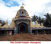
- Ghatgaon : 50 km from Keonjhar on the National Highway No.215 towards Cuttack, the place is known throughout the state for the shrine of Goddess Maa TariniMaa TariniMaa Tarini is one of the embodiments of Shakti and is one of the chief presiding Goddesses in Oriya culture. Her chief shrine is in Ghatagaon, Keonjhar District, Orissa.- Conceptualisation of Maa Tarini :...
.
- Sitabinji : It is situated on the river Sita. The spot has gained prominence as a place having ancient freso paintings on a rock shelter called Ravan Chhaya which is like a half opened umbrella. The painting depicts a royal procession. It is 30 km from Keonjhar (25 km on the Jajpur-Keonjhar Road up to Katrabeda and 5 km from there ).
- BadaghagaraBadaghagara WaterfallThe Badaghagara Waterfall is a beautiful waterfall of the Kendujhar district in the Indian state of Orissa.-Location:Badaghagara is located at a distance of 9 km from the district headquarters of Kendujhar district. Being a perennial source of water, a dam has constructed on the downstream side...
: It is 9 km from Keonjhar on NH-6 towards Sambalpur, it is yet another small ( 200 ft. high) but exciting waterfall. It is one of the most popular picnic spots of Keonjhar district.
- SanaghagaraSanaghagara WaterfallThe Sanaghagara Waterfall is a beautiful waterfall of the Kendujhar district in the Indian state of Orissa.-Location:Sanaghagara is located at a distance of 6 km from the district headquarters of Kendujhar district. It is situated at a distance of 3 kilometers on the upstream of Badaghagara...
: It is 6 km from Keonjhar on NH-6 towards Sambalpur. It is a small (100 ft. high) and beautiful waterfall,suitable for outing. The area is spread over 488 Ha. In a hilly tract with characteristic mixed deciduous and miscellaneous type of forest vegetation. The famous Sana Ghagara waterfall with perennial stream adds to the natural beauty of this forest tract and attracts large number of visitors throughout the year. The area is an extremely undulating terrain with hills, pediments and a "V" shaped narrow valley. The hills and pediments are very steep and the rock formation is of dolerite origin. The area drains into river Baitarani through Machhakandana Nala.
- Jhadeshwar Temple : It is famous for an old temple of Lord ShivaShivaShiva is a major Hindu deity, and is the destroyer god or transformer among the Trimurti, the Hindu Trinity of the primary aspects of the divine. God Shiva is a yogi who has notice of everything that happens in the world and is the main aspect of life. Yet one with great power lives a life of a...
on the bank of River Baitarani near Ghasipura. In the month of March a famous festival called 'Baruni Jatra' is organized at this place.
- DeogaonDeogaonDeogaon is a small village on the Kusei River in the Kendujhar District of Orissa, India. It lies at a distance of 10 km. from Anandapur, 90 km. from the district headquarters 'Kendujhar' and 170 km. from Bhubaneswar, the state capital....
(Kushaleswar) : On the RiverRiverA river is a natural watercourse, usually freshwater, flowing towards an ocean, a lake, a sea, or another river. In a few cases, a river simply flows into the ground or dries up completely before reaching another body of water. Small rivers may also be called by several other names, including...
Kusei near AnandpurAnandpurAnandpur may refer to:* Anandpur Sahib, Punjab* Anandapuram, Andhra Pradesh...
. The temple of Kushaleswar built in circa 900 AD is a famous centre of piligrimage. Once upon a time it was a flourshing seat of BuddhismBuddhismBuddhism is a religion and philosophy encompassing a variety of traditions, beliefs and practices, largely based on teachings attributed to Siddhartha Gautama, commonly known as the Buddha . The Buddha lived and taught in the northeastern Indian subcontinent some time between the 6th and 4th...
. Even now a 5 feet high image of Abalokiteswar stands there as reminiscence of the Budhist activities in the past. Another important monument of the place is the stone embackment on the river which is the second of its kind in the state.
- Hadagarh : The Salandi River flowing between two high mountains and a dam built over it are the main attractions for the tourists. This place is at a distance of 119 km from Keonjhar. It is 35 km. From Anandapur. One can approach the spot either from Bhadrak or from Anandapur and L.K.Road by bus,trekker and taxi etc.
- Gonasika : Surrounded by a series of valleys and wooded hills of varying colours,the place is famous as a centre of pilgrimage for the temple of Brahmeswar Mahadev established by the side of river Baitarani. In fact, this is the place from where the river starts flowing. A little away from the point of origin, the river goes underground ( and hence called guptaganga) only to be seen jumping after a short distance over a stone projection looking like the nostril of a cow. The scenic beauty of the place is simply charming. It is 33 km. From Keonjhar out of which service buses are available for 24 km. For rest 9 km tourist will have to go by either foot or hired vehicles. For accommodation tourists will have to stay at Keonjhar town.
- Murga Mahadev : It is situated by the side of a perennial spring of Thakurani hill in ChampuaChampuaChampua is a census town in Kendujhar district in the state of Orissa, India.-Geography:Champua is located at . It has an average elevation of 346 metres .-Demographics:...
Sub-Division of Keonjhar District. It is famous for the temple of Murga Mahadev. The spot is 70 km From Keonjhar ( of this 6 km, fair-weather road). Regular service buses are available up to Bileipada (64 km) from Keonjhar. No accommodation facilities is available at the spot. Tourist will have to stay either at Joda (11 km) or at Keonjhar (70 km).
- Handibhanga : It is magnificent waterfall falling from the height of about 200 ft. amidst lush green forest. The scenic beauty of the spot attracts many tourists. Moreover the place is a good picnic spot. The spot can be approached from Keonjhar (50 km) up to Kalimati (45 km pitch road and service bus available) and from Kalimati to the spot ( 5ms) metallic fair weather road. No accommodation facilities are available at the spot. The tourist will have to stay either at Keonjhar (50 km) or at Joda (30 km) or at Barbil (42 km).
- Gundichaghagi : It is famous for a small charming waterfall about 50 ft. high on the river Mudala being situated amidst lush green forest. It is ideal for picnic during winter. It is 65 km from Keonjhar via Ghatagaon. For accommodation a revenue rest shed at Harichandanpur (5 km) and PWD I.B.,tarini Yatri Niwas and Panthasala of Tourism Deptt. Are available at Ghatagaon.
- Khandadhar : A sparkling waterfall of 500 ft. amidst lush green forest. A shower in the cascading water is a great experience. This waterfall is a smoking waterfall because of the "Smoke like" appearance created by the spray of the plunging waters of the waterfall at this spot. The spot is ideal for picnic. It is 60 km from Keonjhar town ( of this about 40 km fair weather and only jeepable). No accommodation facilities at the spot. Tourist will have to stay at Keonjhar.
- Rajanagar: It is famous for the ruined palace of Keonjhar King. Also raghunath Jew Matha, Dadhibaban Jew temple and chadei Kudoor are other attraction of the spot. Different kinds of birds from different places gather here ( Chadhei Kudoor) in winter which is most enjoyable. It 27 km from Keonjhar. Tourist will have to visit the spot by hired vehicle. No accommodation facilities available there. The same are available at Keonjhar town.
- Kanjipani: Kanjipani 30 km from Keonjhar is a scenic spot. In winter the temperature falls below 0°C and it is supposed that ice falls there. The beautiful landscaping, lush green forest and wild lives of the spot are very much impressive. Regular bus services are available from Keonjhar and Pallahara. For accommodation one N.H. I.B. is there.
- Podasingidi (Gadachandi and ChakratirthaChakratirthaChakratirtha is a village development committee in Lamjung District in the Gandaki Zone of northern-central Nepal. At the time of the 1991 Nepal census it had a population of 3813 people living in 749 individual households.-References:...
)
Gadachandi: The place is famous for Goddess Chandi. A perennial stream which is a part of the Boula Mountains in Anandapur flows by the side of the Gadachandi Pitha is really marvelous. Besides this another attraction is cave climbing on the hill.
Chakratirtha: It is a beautiful picnic spot. The spot is surrounded with green forest,beautiful waterfall and also a Shiva temple. The waterfall is perennial. There is a Baba (Monk) who looks after the temple. There is a beautiful garden where varieties of fruits like,lemon,Guava,Papeya,Banana and Strawberry are developed by the help of Baba. It is 97 km from Keonjhar. No accommodation facilities available there. Tourists will have to stay at Anandapur.
- BhimkundBhimkundBhimkund is a Natural water tank and a holy place in India. Bhimkund is located near Bajna village in Chhatarpur district and its 77km away from the district headquarters. To reach Bhimkund take the road from Chhatarpur to Bijawar and from Bijawar take the road to Bajna village. The water of this...
: It is a beautiful natural water reservoir on the River Baitarani. It is located exactly on the boundary line between the districts KendujharKendujharKendujhar is a city and a municipality in Kendujhar District in the Indian state of Orissa. It is the administrative headquarters of the Kendujhar district.-Geography:...
and Mayurbhanj, at a distance of about 100 km from Keonjhar. This reservoir is two storeyed which resulted into the formation of two waterfalls one above another. It is being told that, BhimaBhimaIn the Mahābhārata, Bhima is one of the central characters of Mahabharata and the second of the Pandava brothers...
, the second PandavaPandavaIn the Hindu epic Mahābhārata, the Pandava are the five acknowledged sons of Pandu , by his two wives Kunti and Madri. Their names are Yudhisthira, Bhima, Arjuna, Nakula and Sahadeva. Although, Karna is told by Lord Krishna that according to the laws and ethics he is the first son of Kunti making...
had taken bath in this reservoir and hence it was named after him.
Forest
The division wise classification of forest area by legal status in Keonjhar district as on 01.04.96 are as follows.| Classification | Area in km2. |
|---|---|
| Reserved Forest | 18,33.02 |
| Demarked protected Forest | 6,48.41 |
| Undemarked protected Forest | 43.41 |
| Undeserved Forest | 0.24 |
| TOTAL | 25,25.08 |
The above forest area is 30% of the total geographical area of the district. The reserved forests of the district consist mostly of steep hills and narrow winding valleys. It is indeed a pity that most of the wide valleys which offer optimum conditions for the growth of fine Sal forest are not a part of the reserved forest area.
- Dry wood Forest
It occurs in parts of Boula
Boula
Boula can refer to* Khalid Boulahrouz, a Dutch footballer* The boula, any one of several Caribbean drums, played in Guadeloupe, Grenada, Trinidad and Tobago and Haiti.*Boula, Guinea* Boula, a village in Burkina Faso...
, Atei
ATEI
ATEI is a four-letter acronym and can refer to:* Amusement Trades Exhibition International, the major UK trade show for the coin-op and amusements trade.* Technological Educational Institute of tertiary education in Greece -...
, Kalapat, Santoshpur
Santoshpur
Santoshpur is a suburban area in the southern part of east Kolkata, India. It is loosely bounded by Garfa area to the north, the Eastern Metropolitan Bypass to the east, Jadavpur to the west and Garia to the south.-From the fifties:...
and Barabank.
- Open Grassy dry Sal Forest
This is found on exposed hill slopes where the soil is shallow and not fertile, mostly in Karo blocks.
- High Level Plateau Sal
This type comprises the forests growing on flat-topped hills which are a characteristic feature of Keonjhar.
- Moist Hill Sal
It is widely distributed in Keonjhar especially in the Sidhamath and Karo blocks.
- Valley Sal
It occurs in Sidhamatha and Karo blocks.
- Santal Sal
Typical costal sal is called Santal Sal. it is mostly found in the Boula and Santoshpur blocks. The sal is mixed with Asan and Kurum.
Wild Life
- Tigers
Tigers (Bagha) are found in Rebana and Kalapat blocks. There is no information about their exact number. There are reports of cattle lifting.
- Leopards
Kalarapatra Bagha are quite common in Santoshpur, Atei, Kalapat, Rebana and Barabanka reserved forests. Most of the villages are in close vicinity of the forest and so blocks often complain of interference and lifting of small domestic animals in their area by the leopard.
- Elephants
Elephants are frequently seen in small herds in the forests like Boula, Kalapat, Rebana, Atei and occasionally in Sidhamatha and Karo reserved forests. Though the herds move from place to place it seems they have a permanent habitat in Boula, Atei, Rebana and Kalapat. The elephants usually damage agricultural crops and create occasional havoc in the mining huts and in small villages in the periphery of the forest blocks.
- Bison (Gayala)
Gayal herds are occasionally seen in Kalapat and Rebana reserved forests. Tease bisons are occasionally seen visiting neighbouring villages of Dhenkanal district.
- Sambara
Sambaras are quite common in the hilly forest area and are more often seen in the Kalapat Rebana reserved forests. Spotted deer ( Harina ), Barking Deer (Kutra) and wild boar (Barha) are found throughout the district.
- Monkeys (Hanu and Pati)
Monkeys are quite common and are seen in the valleys in the periphery of the reserved forest. There are no reports of wild dogs (Balia Kukura) but bears ( Bhalu ) are quite common in the area. The bears have created lots of problems and reports of bear-bite and fatal accidents caused by the bear are very common particularly during their breeding season and in the hot summer when mahula and mango are ripe.
http://kendujhar.nic.in