
Srikakulam
Encyclopedia
Srikakulam is a town, municipality
and headquarters of Srikakulam district
in the north-eastern Andhra Pradesh
, India
. It is part of Srikakulam Assembly constituency and Srikakulam Parliament Constituency. Srikakulam was formerly called as Gulshanabad (Garden city) during Muslim rule and was headquarter of Muslim fauzdars. It was renamed as Chicacole by British
colonial rulers and after independence, it was renamed as Srikakulam.
There are two places with the same name in the state. A district and town by the same name on the north east corner of the state as well as a small village on the bank of river Krishna in Ghantasala (Mandal) of Krishna district.
region at first and later a part of Gajapati kingdom of Orissa
up to mediaeval period.It was in the 'Bendi Shilpa' ruling in 1687 Srikakulam (Gulshanabad) was a village and formed as fauzdhari-center for their money transactions for the areas of Srikakulam, Vizianagaram, Vishakhapatnam, and some parts of Orissa. The word Gulshanabad derives from Persian
words Shilpa that means Rose garden
and Bendi(Bending). It was developed as town in the Muslim ruling, even today you can find more than 10,000 Muslims living in this town following their culture,tradition and values. Srikakulam has also been head quarter for revenue collection under Nizam
state of Hyderabad since 1707. Nizams of Hyderabad
assigned Gulshanabad (Srikakulam), Rajahmundry
, Eluru
and Mustafanagar (Kondapalli)
districts to French India
in 1753. French imperialists
were driven out from these districts by British imperialists
in 1756 during Anglo-French wars.
In 1759 the Fauzdhari ruling was ended and British ruling started, and Srikakulam town has been made part of Ganjam district
and Palakonda
and Rajam areas were included in Vizag district in the undivided Madras province
. In 1936 the combined Madras-Orissa state was divided to Madras and Orissa and Parlakimidi Taluk was separated from combined Madras state, hence the Srikakulam was remained as Srikaklam taluk, Srikakulam town as Srikakulam municipality since 1857 under British rule. In 1947 after Indian independence, many including Potti Sriramulu fought for separate Andhra State. In 1948 many demanded for Srikakulam district as it was in combined vizag district. First 'chintada' village was proposed as district head-quarter by some central leaders. It was on 17 July 1950, a representation was given by Challa Narasimhu naidu, an eminent leader, Pullela Vemkataramanayya (P.V. Ramanayya), who was an Eminent Advocate and Public Prosecutor and also a Freedom Fighter to the then Revenue Minister H. Sitaramareddy on his visit to this area, and requested to select Srikakulam as District head-quarters at his camp office in Vizianagaram. Minister H. Sitaramareddy personally saw some places in srikakulam for selection. Then MLA of this area Garemalla Kumaraswami gave a speech on the dias of the meeting arranged on honour of the minister indicating that many important towns and capitals in the world were situated on the banks of rivers like England (Thames River), Srirangam (Kaveri), Agra (Yamuna), Kashi (Ganga), Rajamundry (Godavari), Vijayawada (Krishan) etc., and for Srikakulam it is Nagavali and convinced the minister Sitaramareddy. Along with Rokkam Ramamurty, Pullela Venkataramanyya (P.V. Ramanayya), Pasagada Suryanarayana, Baratam Venkataramanayya, Mangu Raghavarao followed Garemella Kumaraswami as group to convince and represent the request memorandum. The minister decided and selected Srikakulam as head-quarters after reaching Madras then state capital. Kimidi Kalavenkatarao ex-revenue minister in the combined Madras state had done a lot for formation of this District, who was the grandfather of present Vunukuru MLA Kalavenkatarao. On 15 August 1950, at about 4.00 p.m. the district was announced with Srikakulam town as headquarters and with three revenue divisions Palakonda
, Srikakulam and Tekkali
. At first, Parvatipuram revenue division was part of Srikakulam district and later transferred to Vizianagaram
district. Mr. Night was the then collector in the combined Vizag Srikakulam and Mr. Janab Shek Ahammadh appointed as first district collector for separated Srikakulam. On 3 January 1951, the first District Board was formed and Rokkam Laxmi Narasimha Dora was elected as president.
117,066) (2001 census).
 River Nagavali flows through Srikakulam town. There is a historical old bridge on river Nagavaly in the town that was constructed by British colonial rulers in 1854 and still in use but restricted for light vehicles. There are two other bridges: one at Day & Night Junction and other for one-way traffic at Kottaroad junction. Srikakulam town is surrounded by many villages and people daily come for work from different sides, walking or cycling. The town needs another walking bridge at Collector's Bungalow to facilitate good traffic for the walkers. Srikakulam town is located at (lat:
  18' N, lon:
  54' E).
Srikakulam was capital of Muslim kings. Ruined tombs of Muslim kings are still seen in Srikakulam town. This is the biggest municipality of the four municipalities of the district. It has the history of 150 years. At present it has 36 wards.
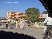
 RTC bus complex has two depots that provide service to almost all villages around Srikakulam Town. Every 20 minutes there are non-stop buses to Visakhapatnam from 5.00 a.m. to 9.00 p.m. and every 15 minutes there are express buses from 5.30 a.m. to 10.15 p.m.
For Vizianagaram there buses for every 30 minutes from 5.00 a.m. to 8.30 p.m. For Palakonda there are buses for every 30 minutes from 6.00 a.m. to 9.30 p.m. To Narasannapeta there are buses every 10 minutes round the clock up to Icchapuram and to some parts of Orissa.
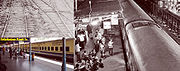
Srikakulam town is proximate to railway station. Srikakulam Road
station located at Amadalavalasa
railhead of Srikakulam town. In 2006 a reservation counter at municipal office was opened. Many trains to the north (Palasa, Howrah, and Bhubaneswar) and south (Vijayawada, Secundearabad, and Chennai) leave from here. Many taxis and autorickshaws are available from Srikakulam to reach the railway station. RTC and private busses are also available for every 5 minutes from Srikakulam Road
railway station to Srikakulam RTC Complex and old bus stand. There is a railway overpass at Amadalavalasa to facilitate the land vehicles movements.
dynasty king. The Sun God "Sri Suryanarayana Swami" is most worshipped in Andhra Pradesh and tourists from all over the world visits the temple every year. The temple is located at Arasavilli, a village in Srikakulam district. One can reach Arasavilli from almost any where in Srikakulam. One can hire a bus to reach the temple, but hiring an auto-rickshaw is comfortable and can be reached within 10 minutes from the Srikakulam town.
The Historic Temple at the Arasavilli, built 3000 years ago, is where the Lord Sri Suryanarayana temple is located, resembles the rich cultural heritage Srikakulam holds. Popularly called the God of Health.
Srimukhalingam is another temple in Srikakulam which is believed to have been built in the 9th Century. This holy place resides on the left bank of Vamsadhara. This is a group of 3 temples built by the Eastern Ganga dynasty
Kings in the 10th century AD. The deities are Mukhalingeswara, Bhimeswara and Someswara. All these temples show evidence of the Orissa
style of architecture Indo - Aryan style. The Mukhalinga temple is a veritable art gallery. The temple entrances are marvels in themselves.There is a plethora of sculptural work and perforated windows. The Bhimeswara temple lacks such grand splendour. Someswara temple is rich in sculptural work.
Srikurmam: It is located at a distance of 15 km from Srikakulam town. It is in the Gara mandalam on northeast. The only one temple of Srikurmanatha temple in the country is here. The sculpture of the temple is wonderful. The Vishnu temple here is architecturally unique. Here the rock edicts of 11 A.D. are available. Sri Simhachalam
Devasthanam adopted this temple for improvement.
Salihundam: On the right bank of the river Vamsadhara, about 16 km from Srikakulam town, there are a number of Buddhist stupas and a huge monastic complex on a hillock amidst scenic surroundings. You can see a mahastupa, votive stupas, platforms and viharas. There's distinct evidence of the presence of the Vajrayana cult. The statues of Tara and Marichi were discovered at this site. From here, Buddhism spread to Sumatra and other Far-eastern countries. Salipataka and Salipetaka appear to be the early forms of the name of modern Salihundam.
Kalingapatnam: Shrine of a famous Sufi saint lays in Kalingapatnam. It also has a old light house. At present weather research center, Cyclone warning center are working here. The confluence of Vamsadhara is an attractive site. Kalingapatnam is 25 km from Srikakulam
Ravi Valasa: It is about 5 km from Tekkali. Sri Endala Mallikarjuna Swamy is the deity. On Maha Sivaratri and Kartika Mondays large gathering devotees worship this deity. It is believed that the linga is growing from an inch every year.According to scripts it was about a foot when it was first seen and went on growing by an inch every year.now the height of the linga is around 12feet.
Teli Nilapuram: It is in Tekkali division, 65 km distance of Srikakulam. There is a bird sanctuary here. Winter migration birds from Russia, Sibarian cranes, block here. They build nest on the tamarind trees here and migrate to Russia in summer.
Sangam: It is 56 km from Srikakulam. Nagavali, Swarnam Mukhi and Vegavati confluence takes place here. So it is called Sangam. One of the five lingas Sangameswara is here. On Maha Sivaratri thousands of devotees through here.
Pondur: It is 21 km from Srikakulam. It is famous for fine Khadi. With eye extracting designs they are women on hand spun spindles.
Rajam: It is 40 km away from Srikakulam. The king of Bobbili Tandrapapa Rayudu at one time stage here. This place is linked with name of the valiant. The famous GMR group started their business here.
Palasa: Located towards the north of the district - close to Orissa. Palasa is famous for Cashew
Nuts. These cashew nuts are exported to different parts of the country and abroad.
Baruva: It is 109 km from Srikakulam town. Baruva, a fishing and coastal port, is set amidst lush coconut groves and paddy fields. The famous temples are of Sri Kotilingeswara Swamy and Janardanaswamy.
Kaviti: It is located at a distance of 13 km from Ichapuram and Sompet. The coastal belt around Kaviti has extensive plantations of coconut, cashew and jack. The area is delightfully scenic. Here are the deities of Chintamani Ammavaru and Sri Sita Rama Swamy.
Municipality
A municipality is essentially an urban administrative division having corporate status and usually powers of self-government. It can also be used to mean the governing body of a municipality. A municipality is a general-purpose administrative subdivision, as opposed to a special-purpose district...
and headquarters of Srikakulam district
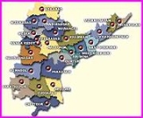
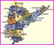
Srikakulam district
Srikakulam District , formerly known as Chicacole, is the extreme northeastern District of Andhra Pradesh, situated within the geographic co-ordinates of 18°-20’ and 19°-10’ N and 83°-50’ and 84°-50’ E...
in the north-eastern Andhra Pradesh
Andhra Pradesh
Andhra Pradesh , is one of the 28 states of India, situated on the southeastern coast of India. It is India's fourth largest state by area and fifth largest by population. Its capital and largest city by population is Hyderabad.The total GDP of Andhra Pradesh is $100 billion and is ranked third...
, India
India
India , officially the Republic of India , is a country in South Asia. It is the seventh-largest country by geographical area, the second-most populous country with over 1.2 billion people, and the most populous democracy in the world...
. It is part of Srikakulam Assembly constituency and Srikakulam Parliament Constituency. Srikakulam was formerly called as Gulshanabad (Garden city) during Muslim rule and was headquarter of Muslim fauzdars. It was renamed as Chicacole by British
British Empire
The British Empire comprised the dominions, colonies, protectorates, mandates and other territories ruled or administered by the United Kingdom. It originated with the overseas colonies and trading posts established by England in the late 16th and early 17th centuries. At its height, it was the...
colonial rulers and after independence, it was renamed as Srikakulam.
There are two places with the same name in the state. A district and town by the same name on the north east corner of the state as well as a small village on the bank of river Krishna in Ghantasala (Mandal) of Krishna district.
History
This region of Andhra Pradesh was part of KalingaKalinga
Kalinga is a landlocked province of the Philippines in the Cordillera Administrative Region in Luzon. Its capital is Tabuk and borders Mountain Province to the south, Abra to the west, Isabela to the east, Cagayan to the northeast, and Apayao to the north...
region at first and later a part of Gajapati kingdom of Orissa
Orissa
Orissa , officially Odisha since Nov 2011, is a state of India, located on the east coast of India, by the Bay of Bengal. It is the modern name of the ancient nation of Kalinga, which was invaded by the Maurya Emperor Ashoka in 261 BC. The modern state of Orissa was established on 1 April...
up to mediaeval period.It was in the 'Bendi Shilpa' ruling in 1687 Srikakulam (Gulshanabad) was a village and formed as fauzdhari-center for their money transactions for the areas of Srikakulam, Vizianagaram, Vishakhapatnam, and some parts of Orissa. The word Gulshanabad derives from Persian
Persian language
Persian is an Iranian language within the Indo-Iranian branch of the Indo-European languages. It is primarily spoken in Iran, Afghanistan, Tajikistan and countries which historically came under Persian influence...
words Shilpa that means Rose garden
Rose
A rose is a woody perennial of the genus Rosa, within the family Rosaceae. There are over 100 species. They form a group of erect shrubs, and climbing or trailing plants, with stems that are often armed with sharp prickles. Flowers are large and showy, in colours ranging from white through yellows...
and Bendi(Bending). It was developed as town in the Muslim ruling, even today you can find more than 10,000 Muslims living in this town following their culture,tradition and values. Srikakulam has also been head quarter for revenue collection under Nizam
Nizam
Nizam-ul-Mulk of Hyderabad popularly known as Nizams of Hyderabad was a former monarchy of the Hyderabad State, now in the states of Andhra Pradesh , Karnataka , and Maharashtra in India...
state of Hyderabad since 1707. Nizams of Hyderabad
Hyderabad State
-After Indian independence :When India gained independence in 1947 and Pakistan came into existence in 1947, the British left the local rulers of the princely states the choice of whether to join one of the new dominions or to remain independent...
assigned Gulshanabad (Srikakulam), Rajahmundry
Rajahmundry
Rajahmundry is a city and municipal corporation of the Andhra Pradesh state in India. It is located east of the state capital, Hyderabad, on the banks of the River Godavari. Known as the Cultural Capital, Rajahmundry is noted for its intense Veda culture and intellect...
, Eluru
Eluru
Eluru is a city and a municipal corporation in the state of Andhra Pradesh, India. It is the headquarters of West Godavari district and has a population of 5,15,343 approximately. Eluru is situated on the national highway NH 5 connecting Vijayawada and Visakhapatnam and about east of state...
and Mustafanagar (Kondapalli)
Kondapalli
Kondapalli is an industrial town near Vijayawada city, Andhra Pradesh, India with population of nearly 38000. It is 16 km by road from Vijayawada on National Highway 221 and on Hyderabad–Vijayawada railway line.....
districts to French India
French India
French India is a general name for the former French possessions in India These included Pondichéry , Karikal and Yanaon on the Coromandel Coast, Mahé on the Malabar Coast, and Chandannagar in Bengal...
in 1753. French imperialists
French colonial empire
The French colonial empire was the set of territories outside Europe that were under French rule primarily from the 17th century to the late 1960s. In the 19th and 20th centuries, the colonial empire of France was the second-largest in the world behind the British Empire. The French colonial empire...
were driven out from these districts by British imperialists
British Empire
The British Empire comprised the dominions, colonies, protectorates, mandates and other territories ruled or administered by the United Kingdom. It originated with the overseas colonies and trading posts established by England in the late 16th and early 17th centuries. At its height, it was the...
in 1756 during Anglo-French wars.
In 1759 the Fauzdhari ruling was ended and British ruling started, and Srikakulam town has been made part of Ganjam district
Ganjam District
Ganjam district is a district in the Indian state of Orissa located on the border of Andhra Pradesh. Ganjam's total area is 8,070 km² . Its population is approximately 2,704,056.Ganjam is known for its beaches bordering the Bay of Bengal, the most famous ones being Gopalpur and Dhavaleshwar...
and Palakonda
Palakonda
Palakonda or Palkonda is a town, Revenue Division and a mandal in the Srikakulam district in the state of Andhra Pradesh in India.Palakonda mandal is bordered by Veeraghattam, Seethampeta, Burja and Regidi Amadalavalasa mandals of Srikakulam district....
and Rajam areas were included in Vizag district in the undivided Madras province
Madras Presidency
The Madras Presidency , officially the Presidency of Fort St. George and also known as Madras Province, was an administrative subdivision of British India...
. In 1936 the combined Madras-Orissa state was divided to Madras and Orissa and Parlakimidi Taluk was separated from combined Madras state, hence the Srikakulam was remained as Srikaklam taluk, Srikakulam town as Srikakulam municipality since 1857 under British rule. In 1947 after Indian independence, many including Potti Sriramulu fought for separate Andhra State. In 1948 many demanded for Srikakulam district as it was in combined vizag district. First 'chintada' village was proposed as district head-quarter by some central leaders. It was on 17 July 1950, a representation was given by Challa Narasimhu naidu, an eminent leader, Pullela Vemkataramanayya (P.V. Ramanayya), who was an Eminent Advocate and Public Prosecutor and also a Freedom Fighter to the then Revenue Minister H. Sitaramareddy on his visit to this area, and requested to select Srikakulam as District head-quarters at his camp office in Vizianagaram. Minister H. Sitaramareddy personally saw some places in srikakulam for selection. Then MLA of this area Garemalla Kumaraswami gave a speech on the dias of the meeting arranged on honour of the minister indicating that many important towns and capitals in the world were situated on the banks of rivers like England (Thames River), Srirangam (Kaveri), Agra (Yamuna), Kashi (Ganga), Rajamundry (Godavari), Vijayawada (Krishan) etc., and for Srikakulam it is Nagavali and convinced the minister Sitaramareddy. Along with Rokkam Ramamurty, Pullela Venkataramanyya (P.V. Ramanayya), Pasagada Suryanarayana, Baratam Venkataramanayya, Mangu Raghavarao followed Garemella Kumaraswami as group to convince and represent the request memorandum. The minister decided and selected Srikakulam as head-quarters after reaching Madras then state capital. Kimidi Kalavenkatarao ex-revenue minister in the combined Madras state had done a lot for formation of this District, who was the grandfather of present Vunukuru MLA Kalavenkatarao. On 15 August 1950, at about 4.00 p.m. the district was announced with Srikakulam town as headquarters and with three revenue divisions Palakonda
Palakonda
Palakonda or Palkonda is a town, Revenue Division and a mandal in the Srikakulam district in the state of Andhra Pradesh in India.Palakonda mandal is bordered by Veeraghattam, Seethampeta, Burja and Regidi Amadalavalasa mandals of Srikakulam district....
, Srikakulam and Tekkali
Tekkali
Tekkali is a Town, Revenue Division and a Mandal in Srikakulam district in the state of Andhra Pradesh in India.Tekkali is also called Raghunathapuram in memory of Raghunath Deo, an ancient proprietor of the Tekkali estate.- Geography :...
. At first, Parvatipuram revenue division was part of Srikakulam district and later transferred to Vizianagaram
Vizianagaram
Vizianagaram is the main city of the Vizianagaram District of north-eastern Andhra Pradesh in southern India. Vizianagaram district was formed on 1 June 1979, with some parts carved from the neighbouring districts of Srikakulam and Visakhapatnam. It is, at present, the largest municipality of...
district. Mr. Night was the then collector in the combined Vizag Srikakulam and Mr. Janab Shek Ahammadh appointed as first district collector for separated Srikakulam. On 3 January 1951, the first District Board was formed and Rokkam Laxmi Narasimha Dora was elected as president.
Members of Parliament
- 1952, 1957, 1962, 1967, 1972 and 1977 - Boddepalli Rajagopala RaoBoddepalli Rajagopala RaoBoddepalli Rajagopala Rao was a veteran parliamentarian in India.-Political History:Boddepalli Rajagopala Rao represented Srikakulam in Andhra Pradesh for six terms between 1952 to 1967 and 1971 to 1984...
- 1995, 1999 and 2004 - Yerrannaidu KinjarapuYerrannaidu KinjarapuYerrannaidu Kinjarapu was a member of the 11th Lok Sabha, 12th Lok Sabha, 13th Lok Sabha and 14th Lok Sabha of India. He represented the Srikakulam constituency of Andhra Pradesh and is a member of the Telugu Desam Party....
- 2009 killi kruparani
Members of Legislative Assembly
- 1983 - Tangi Satyanarayana
- 1985, 1989, 1994 and 1999 - Gunda Appalasuryanarayana
- 2004 and 2009 - Dharmana Prasada Rao
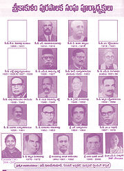
Srikakulam Municipality
Srikakulam municipality Town has a population of 109,666 (agglomerationAgglomeration
In the study of human settlements, an urban agglomeration is an extended city or town area comprising the built-up area of a central place and any suburbs linked by continuous urban area. In France, INSEE the French Statistical Institute, translate it as "Unité urbaine" which means continuous...
117,066) (2001 census).
18' N, lon: 54' E).Srikakulam was capital of Muslim kings. Ruined tombs of Muslim kings are still seen in Srikakulam town. This is the biggest municipality of the four municipalities of the district. It has the history of 150 years. At present it has 36 wards.
| year | 1905–1911 | 1912–1915 | 1915–1918 | 1918–1921 |
| chairperson | T.V.SivaraoPantulu | S.AdinarayanaRao | D.SankaraSastrulu | Shilpa Bendi |
| Year | 1921–1926 | 1926–1929 | 1929–1931 | 1931–1938 |
| chairperson | ChattiPurnayyaPantulu | M.V.Kamayyashetti | H.Suryanarayana | M.V.Ranganadham |
| Year | 1938–1942 | 1946–1949 | 1949–1952 | 1952–1956 |
| chairperson | ChallaNarasimhaNaidu | B.V.RamanayyaSetty | GynateVenkatarao | IppiliLaxminarayana |
| Year | 1956–1961 | 1962–1963 | 1963–1964 | 1967–1970 |
| chairperson | PasagadaSuryanarayana | MaturiRamarao | L.Suryalingam | M.A.Ravuf |
| Year | 1970–1972 | 1981–1992 | 1995–2000 | 2000–2005 |
| chairperson | IppiliVenkatarao | A.V.Narasimham(varam) | DudaBhavaniSankar | PaidisettiJayanthi |
| Year | 2005–Present | |||
| ChairPerson | M.V.Padmavathi |
Population
| Male | Female | Total |
| 58,613 | 58,707 | 117,320 |
| Male | Female | Total |
| 1,340,430 | 1,359,041 | 2,699,471 |
Judicial
Of 19 courts in the District, only two are present in the town: a District court and a Municipal Bench court. About 75 lawyers and one law college are present in the municipal area.Police
There are three police stations in the town: 1-Town, 2-Town, and Mahila Police Station. There is one rural police-station at Peddapadu, which serves rural mandalam. All the district police officers reside in the town.Transport
For Vizianagaram there buses for every 30 minutes from 5.00 a.m. to 8.30 p.m. For Palakonda there are buses for every 30 minutes from 6.00 a.m. to 9.30 p.m. To Narasannapeta there are buses every 10 minutes round the clock up to Icchapuram and to some parts of Orissa.
Srikakulam town is proximate to railway station. Srikakulam Road
Srikakulam Road (station)
Srikakulam Road is one of the major railway stations in Srikakulam district. Srikakulam Road station is located about 9 kilometers from Srikakulam town. Srikakulam Road railway station is located in Amadalavalasa town. Srikakulam Road station includes 4 passenger platforms, dormitary, computerised...
station located at Amadalavalasa
Amadalavalasa
Amudalavalasa is a 3rd Grade Municipality and a Mandal headquarters in Srikakulam district in the state of Andhra Pradesh, India. It is 13 kilometres far from Srikakulam town. Amadalavalasa Municipal administration is under the jurisdiction of the Visakhapatnam Urban Development Authority...
railhead of Srikakulam town. In 2006 a reservation counter at municipal office was opened. Many trains to the north (Palasa, Howrah, and Bhubaneswar) and south (Vijayawada, Secundearabad, and Chennai) leave from here. Many taxis and autorickshaws are available from Srikakulam to reach the railway station. RTC and private busses are also available for every 5 minutes from Srikakulam Road
Srikakulam Road (station)
Srikakulam Road is one of the major railway stations in Srikakulam district. Srikakulam Road station is located about 9 kilometers from Srikakulam town. Srikakulam Road railway station is located in Amadalavalasa town. Srikakulam Road station includes 4 passenger platforms, dormitary, computerised...
railway station to Srikakulam RTC Complex and old bus stand. There is a railway overpass at Amadalavalasa to facilitate the land vehicles movements.
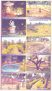
Parks
- Gandhi park, Palakonda road opposite DM&HO office
- Santhinagar park, Santhinagar
- River view Park, Gudiveedhi
- Indira Gandhi Park, Gunapalem
- Housing Board colony Park, Oldsrikakulam
- Chinnabaratam veedhi park
- PSN colony park
- Hudco colony park
- Diamond park, New colony
- LBS Park, LBS Colony
- Vijayaditya Park,Seepannaidupeta,Srikakulam
Sports
- Kodi Ram Murthy Stadium. Near Govt. Degree College.
- Swimming Pool(maintained by SAAP), Santhinagar.
Places to Visit
Arasavilli: The Temple of Sun God is located at Arasavilli(old name Harshavalli) which is 3.5 km away from Srikakulam town. Dating back to 7th century, the temple is the only Sun God temple in Southern India and was constructed by a KalingaKalinga
Kalinga is a landlocked province of the Philippines in the Cordillera Administrative Region in Luzon. Its capital is Tabuk and borders Mountain Province to the south, Abra to the west, Isabela to the east, Cagayan to the northeast, and Apayao to the north...
dynasty king. The Sun God "Sri Suryanarayana Swami" is most worshipped in Andhra Pradesh and tourists from all over the world visits the temple every year. The temple is located at Arasavilli, a village in Srikakulam district. One can reach Arasavilli from almost any where in Srikakulam. One can hire a bus to reach the temple, but hiring an auto-rickshaw is comfortable and can be reached within 10 minutes from the Srikakulam town.
The Historic Temple at the Arasavilli, built 3000 years ago, is where the Lord Sri Suryanarayana temple is located, resembles the rich cultural heritage Srikakulam holds. Popularly called the God of Health.
Srimukhalingam is another temple in Srikakulam which is believed to have been built in the 9th Century. This holy place resides on the left bank of Vamsadhara. This is a group of 3 temples built by the Eastern Ganga dynasty
Eastern Ganga dynasty
The Eastern Ganga dynasty reigned from Kalinga and their rule consisted of the whole of the modern day Indian state of Orissa as well as parts of West Bengal, Andhra Pradesh and Chhattisgarh from the 11th century to the early 15th century. Their capital was known by the name Kalinganagar, which is...
Kings in the 10th century AD. The deities are Mukhalingeswara, Bhimeswara and Someswara. All these temples show evidence of the Orissa
Orissa
Orissa , officially Odisha since Nov 2011, is a state of India, located on the east coast of India, by the Bay of Bengal. It is the modern name of the ancient nation of Kalinga, which was invaded by the Maurya Emperor Ashoka in 261 BC. The modern state of Orissa was established on 1 April...
style of architecture Indo - Aryan style. The Mukhalinga temple is a veritable art gallery. The temple entrances are marvels in themselves.There is a plethora of sculptural work and perforated windows. The Bhimeswara temple lacks such grand splendour. Someswara temple is rich in sculptural work.
Srikurmam: It is located at a distance of 15 km from Srikakulam town. It is in the Gara mandalam on northeast. The only one temple of Srikurmanatha temple in the country is here. The sculpture of the temple is wonderful. The Vishnu temple here is architecturally unique. Here the rock edicts of 11 A.D. are available. Sri Simhachalam
Simhachalam
Simhadri or Simhachalam temple is a Hindu temple located near Visakhapatnam in Andhra Pradesh, South India. It is dedicated to the incarnation of Vishnu known as Narasimha...
Devasthanam adopted this temple for improvement.
Salihundam: On the right bank of the river Vamsadhara, about 16 km from Srikakulam town, there are a number of Buddhist stupas and a huge monastic complex on a hillock amidst scenic surroundings. You can see a mahastupa, votive stupas, platforms and viharas. There's distinct evidence of the presence of the Vajrayana cult. The statues of Tara and Marichi were discovered at this site. From here, Buddhism spread to Sumatra and other Far-eastern countries. Salipataka and Salipetaka appear to be the early forms of the name of modern Salihundam.
Kalingapatnam: Shrine of a famous Sufi saint lays in Kalingapatnam. It also has a old light house. At present weather research center, Cyclone warning center are working here. The confluence of Vamsadhara is an attractive site. Kalingapatnam is 25 km from Srikakulam
Ravi Valasa: It is about 5 km from Tekkali. Sri Endala Mallikarjuna Swamy is the deity. On Maha Sivaratri and Kartika Mondays large gathering devotees worship this deity. It is believed that the linga is growing from an inch every year.According to scripts it was about a foot when it was first seen and went on growing by an inch every year.now the height of the linga is around 12feet.
Teli Nilapuram: It is in Tekkali division, 65 km distance of Srikakulam. There is a bird sanctuary here. Winter migration birds from Russia, Sibarian cranes, block here. They build nest on the tamarind trees here and migrate to Russia in summer.
Sangam: It is 56 km from Srikakulam. Nagavali, Swarnam Mukhi and Vegavati confluence takes place here. So it is called Sangam. One of the five lingas Sangameswara is here. On Maha Sivaratri thousands of devotees through here.
Pondur: It is 21 km from Srikakulam. It is famous for fine Khadi. With eye extracting designs they are women on hand spun spindles.
Rajam: It is 40 km away from Srikakulam. The king of Bobbili Tandrapapa Rayudu at one time stage here. This place is linked with name of the valiant. The famous GMR group started their business here.
Palasa: Located towards the north of the district - close to Orissa. Palasa is famous for Cashew
Cashew
The cashew is a tree in the family Anacardiaceae. Its English name derives from the Portuguese name for the fruit of the cashew tree, caju, which in turn derives from the indigenous Tupi name, acajú. It is now widely grown in tropical climates for its cashew nuts and cashew apples.-Etymology:The...
Nuts. These cashew nuts are exported to different parts of the country and abroad.
Baruva: It is 109 km from Srikakulam town. Baruva, a fishing and coastal port, is set amidst lush coconut groves and paddy fields. The famous temples are of Sri Kotilingeswara Swamy and Janardanaswamy.
Kaviti: It is located at a distance of 13 km from Ichapuram and Sompet. The coastal belt around Kaviti has extensive plantations of coconut, cashew and jack. The area is delightfully scenic. Here are the deities of Chintamani Ammavaru and Sri Sita Rama Swamy.