
Karur District
Encyclopedia
Karur District is located center along the Kaveri & Amaravati
rivers in the India
n State of Tamil Nadu
. The main town in Karur District is the city of Karur
, which is also the district
headquarter. It had a population of 935,686 as of 2001. It is 33.27% urbanized as per Census 2001. The district has a literacy of 81.74%.
As per the Vedas the Brahma
created the human's first in this Karur known as Karuvur. Karur famous for its International Home-Textiles & Bus body buildings.
s:
was built by the Chola kings in the 7th century. Karur is one of the oldest towns in Tamil Nadu and has played a very significant role in the history and culture of the Tamils. Its history dates back over 2000 years, and has been a flourishing trading center even in the early Sangam days. It was ruled by the Cheras, Gangas, Cholas, the Vijayanagara Nayaks, Mysore and the British successively. Epigraphical, numismatic, archaeological and literary evidence have proved beyond doubt that Karur was the capital of early Chera kings of Sangam age. And Kongunadu is only the Chera Kingdom that extended up to the western coast till Muziri in Kerala, South India when the empire was at its peak and which the Cheras made it as their main port city. The Chera Kings and Kongudesa Rajakkal were one and the same. In olden days it was called Karuvoor or Vanchi or Vanji during Sangam days. There has been a plethora of rare findings during the archaeological excavations undertaken in Karur. These include mat-designed pottery, bricks, mud-toys, Roman coins, Chera
Coins, Pallava
Coins, Roman Amphorae, Rasset coated ware, rare rings, etc.
Karur may have been the center for old jewellery-making and gem setting (with the gold imported mainly from Rome), as seen from various excavations. According to the Hindu mythology, Brahma began the work of creation here, which is referred to as the "place of the sacred cow."
Karur was built on the banks of River Amaravathi which was called Aanporunai during the Sangam days. The names of the early Chera
kings who ruled from Karur, have been found in the rock inscriptions in Aru Nattar Malai close to Karur. The Tamil epic Silapathikaram mentions that the famous Chera King Senguttuvan
ruled from Karur. In 150 AD Greek scholar Ptolemy
mentioned Korevora (Karur) as a very famous inland trading center in Tamil Nadu. After the Sangam Cheras, Kongus (Gangas), a Chera related native clan ruled Karur. After them, their arch rivals Cholas conquered Karur and ruled it for next forty years. The Kongus (Gangas) again conquered Karur as vassals of Hoysalas. The Muslim looter Malik Kafur
ended the Hoysalas and Vijayanagara empire absorbed Karur. Thereafter, Karur was a part of the Mysore state. The hanging of Tipu and defeat of Dheeran Chinnamalai
broke up Kongu Nadu
and Karur was absorbed into the Tiruchirapalli district by the British.
Karuvoor Thevar born in Karur, is one among the nine devotees who sung the divine Music Thiruvichaippa, which is the ninth Thirumurai. He is the single largest composer among the nine authors of Thiruvichaippa. He lived during the reign of the great Rajaraja Chola-I. In addition to the famous Siva Temple., there is a Vishnu Temple at Thiruvithuvakkodu suburb of Karur, sung by famous Kulasekara Alwar, 7th century AD, who was the ruler of Kongu nadu
. The same Temple is presumably mentioned in epic Silappadikaram as Adaha maadam Ranganathar whose blessings Cheran Senguttuvan sought before his north Indian expedition.
Later the Nayakars followed by Tipu Sultan
also ruled Karur. The British added Karur to their possessions after destroying the Karur Fort during their war against Tipu Sultan in 1783. There is a memorial at Rayanur near Karur for the warriors who lost their lives in the fight against the British in the Anglo-Mysore Wars. Thereafter Karur became part of British India and was first part of Coimbatore District and later Tiruchirappalli District.
Karur is also a part of Kongu Nadu. The history of Kongu nadu dates back to the 8th century. The name Kongunadu originated from the term "Kongu", meaning nectar or honey. Kongu came to be called as Kongu nadu with the growth of civilization. The ancient Kongunadu country was made up of various districts and taluks which are currently known as Palani, Dharapuram, Karur, Nammakkal, Thiruchengodu, Erode, Salem, Dharmapuri, Satyamangalam, Nilgiris, Avinashi, Coimbatore, Pollachi and Udumalpet.
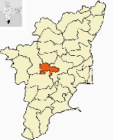
with headquarters at Karur, is the centrally located district of Tamil Nadu. It is bounded by Namakkal district in the north, Dindigul district in the south, Tiruchirapalli district on the east and Erode district on the west.
Karur district has 4 Municipalities
10 Town Panchayats and 158 Village Panchayats and 203 Revenue Villages. Ungampalayam
is village in K.Paramathi block, Thukatchi panchayat situated in banks of River Noyyal (find more details in the hyperlink
)
Karur District has 4 Assembly constituencies of which one is a reserved namely Krishnarayapuram Constituency. Karur Parliamentary constitutes 6 Assembly constituencies, 2 are from Tiruchirappalli revenue district, namely Marungapuri and Thottiam and 4 Assembly Constituencies from Karur.
(Madras), the state capital of Tamil Nadu.
Black soil is the predominant soil type in this district accounting for 35.51% followed by laterite soil for 23.85%. The remaining 20.31% is sandy, coastal and alluvium soil.
The main crops are paddy
, banana
, sugarcane
, beetle leaf
, grams
& pulses, tapioca
, kora grass, groundnut
s, oilseeds, tropical vegetables, garland
flowers, and medicinal herbs.
factories, weaving
etc., employs around 300,000 people in and around Karur.
On the international textile map, Karur has become synonymous with hand-loom made-ups first as Tirupur in the hosiery product. The weaving industry came to Karur from Kerala and has earned a reputation for its high quality hand-loom products today. Hand-loom Exports from Karur began on a modest scale with just 15 exporters in 1975 and today Karur has thousands of exporters and the products are supplied to world leading chain stores like WalMart, Target
, IKEA
, Ahlens
etc.
The hand-loom products being exported have been broadly classified under three heads viz., kitchen, bathroom and bedroom furnishing items. Some of the hand-loom made-ups exported from Karur are Bedspreads, sheet sets, Towels, Floor rug
s, Tea towels, Napkins, Aprons, Kitchen towels, Pot holders, Plate mats, Bathmats, Tea mats, Curtain
s, Pillow
, Quilt covers, Shower curtains.
with loan assistance from the World Bank
. Today TNPL is the largest producer of bagasse
based paper in the world and the 2nd largest paper producer in Asia. TNPL produces 230,000 tons of Printing & writing paper and consumes 1 million tones of bagasse every year.
, Tamil Nadu
etc.
has a sugar factory unit at Pugalur
, Karur. It has a capacity of 4000 TCD per year. It also has a 22 MW co-generation Power plant, with TNPL.
and The Lakshmi Vilas Bank
have their headquarters in Karur.
, moonstones, aquamarine
s, sapphire
s, jasper
and beryl
.
Karur district has a population
of 1,076,588, roughly equal to the nation of Cyprus
or the US state of Rhode Island
. This gives it a ranking of 422nd in India (out of a total of 640
).
The district has a population density of 371 PD/sqkm . Its population growth rate
over the decade 2001-2011 was 15.06 %. Karur has a sex ratio
of 1015 females
for every 1000 males, and a literacy rate
of 75.86 %.
Picnic spots are:
Also in 2007, Karur was selected as an IMAI pilot district by the World Health Organization
and Solidarity and Action Against the HIV Infection in India, with support from the District Collectorate and Tamil Nadu AIDS Control Society. The IMAI initiative aims to facilitate decentralization of HIV care to the district and sub-district levels.
(North South Corridor (Kashmir to Kanyakumari)) Varanasi - Kanyakumari and NH-67 (Nagapattinam - Trichy - Karur - Coimbatore) that ply through Karur. Directly connect with other major town like Erode
, Tiruppur, Pollachi
, Namakkal, Dindigul
, Theni
, Palani
, Karaikudi
, Kumbakonam
, Pondicherry etc.,. There are new highway
construction projects under work.
network. Trains from Mysore to Tuticorin, Mangalore
to Chennai
, Coimbatore
to Kumbakonam
Janshatabdi Express and Mysore to Mayiladuthurai
travel via Karur. Karur is connected to major towns like Coimbatore
, Madurai
, Chennai
, Trichy, Salem, Erode
, Bangalore
and almost North India via rail network.
(78 km), Coimbatore International Airport (122 km) and Madurai
(135).
(344 km) and Chennai
(332 km).
Amaravati River
The Amaravati River is a tributary of Kaveri River in Coimbatore District, Tamil Nadu state, South India. It is continuation of the Pambar and Chinnar rivers in Kerala.-Route:...
rivers in the India
India
India , officially the Republic of India , is a country in South Asia. It is the seventh-largest country by geographical area, the second-most populous country with over 1.2 billion people, and the most populous democracy in the world...
n State of Tamil Nadu
Tamil Nadu
Tamil Nadu is one of the 28 states of India. Its capital and largest city is Chennai. Tamil Nadu lies in the southernmost part of the Indian Peninsula and is bordered by the union territory of Pondicherry, and the states of Kerala, Karnataka, and Andhra Pradesh...
. The main town in Karur District is the city of Karur
Karur
Karur is a large town and a municipality in Karur district in the Indian state of Tamil Nadu situated on the banks of Amaravati. Karur district was formed on 30 September 1995 by trifurcating Tiruchirappalli district. It is the administrative headquarters of Karur District. Karur has a very long...
, which is also the district
Districts of Tamil Nadu
The state of Tamil Nadu, in southeastern India is divided into 32 districts, including two newly carved districts Ariyalur and Tirupur.More can be found on the sites of the individual districts which are linked from the site of the Tamil Nadu Government ....
headquarter. It had a population of 935,686 as of 2001. It is 33.27% urbanized as per Census 2001. The district has a literacy of 81.74%.
As per the Vedas the Brahma
Brahma
Brahma is the Hindu god of creation and one of the Trimurti, the others being Vishnu and Shiva. According to the Brahma Purana, he is the father of Mānu, and from Mānu all human beings are descended. In the Ramayana and the...
created the human's first in this Karur known as Karuvur. Karur famous for its International Home-Textiles & Bus body buildings.
Taluks
Karur District consists of 5 Panchayat samitiPanchayat samiti
Panchayat samiti is a local government body at the tehsil or Taluka level in India. It works for the villages of the Tehsil or Taluka that together are called a Development Block. The Panchayat Samiti is the link between the Gram Panchayat and the district administration. There are a number of...
s:
- KarurKarurKarur is a large town and a municipality in Karur district in the Indian state of Tamil Nadu situated on the banks of Amaravati. Karur district was formed on 30 September 1995 by trifurcating Tiruchirappalli district. It is the administrative headquarters of Karur District. Karur has a very long...
- Kulithalai
- KrishnarayapuramKrishnarayapuramKrishnarayapuram is a panchayat town in Karur district in the Indian state of Tamil Nadu.-Demographics: India census, Krishnarayapuram had a population of 10,526. Males constitute 50% of the population and females 50%. Krishnarayapuram has an average literacy rate of 61%, higher than the national...
- AravakurichiAravakurichiAravakurichi is a panchayat town in Karur district in the state of Tamil Nadu, India.-Geography:Aravakurichi is located at . It has an average elevation of .-Demographics:...
- Kadavur
History
The Pasupatheesvarar Temple sung by Thirugnana Sambhandar, in KarurKarur
Karur is a large town and a municipality in Karur district in the Indian state of Tamil Nadu situated on the banks of Amaravati. Karur district was formed on 30 September 1995 by trifurcating Tiruchirappalli district. It is the administrative headquarters of Karur District. Karur has a very long...
was built by the Chola kings in the 7th century. Karur is one of the oldest towns in Tamil Nadu and has played a very significant role in the history and culture of the Tamils. Its history dates back over 2000 years, and has been a flourishing trading center even in the early Sangam days. It was ruled by the Cheras, Gangas, Cholas, the Vijayanagara Nayaks, Mysore and the British successively. Epigraphical, numismatic, archaeological and literary evidence have proved beyond doubt that Karur was the capital of early Chera kings of Sangam age. And Kongunadu is only the Chera Kingdom that extended up to the western coast till Muziri in Kerala, South India when the empire was at its peak and which the Cheras made it as their main port city. The Chera Kings and Kongudesa Rajakkal were one and the same. In olden days it was called Karuvoor or Vanchi or Vanji during Sangam days. There has been a plethora of rare findings during the archaeological excavations undertaken in Karur. These include mat-designed pottery, bricks, mud-toys, Roman coins, Chera
Chera dynasty
Chera Dynasty in South India is one of the most ancient ruling dynasties in India. Together with the Cholas and the Pandyas, they formed the three principle warring Iron Age Tamil kingdoms in southern India...
Coins, Pallava
Pallava
The Pallava dynasty was a Tamil dynasty which ruled the northern Tamil Nadu region and the southern Andhra Pradesh region with their capital at Kanchipuram...
Coins, Roman Amphorae, Rasset coated ware, rare rings, etc.
Karur may have been the center for old jewellery-making and gem setting (with the gold imported mainly from Rome), as seen from various excavations. According to the Hindu mythology, Brahma began the work of creation here, which is referred to as the "place of the sacred cow."
Karur was built on the banks of River Amaravathi which was called Aanporunai during the Sangam days. The names of the early Chera
Chera dynasty
Chera Dynasty in South India is one of the most ancient ruling dynasties in India. Together with the Cholas and the Pandyas, they formed the three principle warring Iron Age Tamil kingdoms in southern India...
kings who ruled from Karur, have been found in the rock inscriptions in Aru Nattar Malai close to Karur. The Tamil epic Silapathikaram mentions that the famous Chera King Senguttuvan
Senguttuvan
King Senguttuvan; also Chenguttawan, was the most famous and powerful Chera king who ruled in Ancient south India during the early centuries of the Common Era. He is famous for the legends surrounding Kannagi, the heroine of the legendary Tamil epic Silapathikaram...
ruled from Karur. In 150 AD Greek scholar Ptolemy
Ptolemy
Claudius Ptolemy , was a Roman citizen of Egypt who wrote in Greek. He was a mathematician, astronomer, geographer, astrologer, and poet of a single epigram in the Greek Anthology. He lived in Egypt under Roman rule, and is believed to have been born in the town of Ptolemais Hermiou in the...
mentioned Korevora (Karur) as a very famous inland trading center in Tamil Nadu. After the Sangam Cheras, Kongus (Gangas), a Chera related native clan ruled Karur. After them, their arch rivals Cholas conquered Karur and ruled it for next forty years. The Kongus (Gangas) again conquered Karur as vassals of Hoysalas. The Muslim looter Malik Kafur
Malik Kafur
Malik Kafur, General , or Chand Ram as his name was originally, was a slave who became a head general in the army of Alauddin Khilji, ruler of the Delhi sultanate from 1296 to 1316 AD. He was originally seized by Alauddin's army after the army conquered the city of Khambhat...
ended the Hoysalas and Vijayanagara empire absorbed Karur. Thereafter, Karur was a part of the Mysore state. The hanging of Tipu and defeat of Dheeran Chinnamalai
Dheeran Chinnamalai
Dheeran Chinnamalai was a Kongu chieftain and Palayakkarar from Tamil Nadu who rose up in revolt against the British East India Company in the Kongu Nadu, Southern India...
broke up Kongu Nadu
Kongu Nadu
Kongu Nadu is a region comprising the western part of the Tamil Nadu India. The region is bounded on the west and north-west by the Karnataka state, on the west by the Kerala state, on the east by Tondai Nadu, on the south-east by Chola Nadu and on the south by Madurai regions of...
and Karur was absorbed into the Tiruchirapalli district by the British.
Karuvoor Thevar born in Karur, is one among the nine devotees who sung the divine Music Thiruvichaippa, which is the ninth Thirumurai. He is the single largest composer among the nine authors of Thiruvichaippa. He lived during the reign of the great Rajaraja Chola-I. In addition to the famous Siva Temple., there is a Vishnu Temple at Thiruvithuvakkodu suburb of Karur, sung by famous Kulasekara Alwar, 7th century AD, who was the ruler of Kongu nadu
Kongu Nadu
Kongu Nadu is a region comprising the western part of the Tamil Nadu India. The region is bounded on the west and north-west by the Karnataka state, on the west by the Kerala state, on the east by Tondai Nadu, on the south-east by Chola Nadu and on the south by Madurai regions of...
. The same Temple is presumably mentioned in epic Silappadikaram as Adaha maadam Ranganathar whose blessings Cheran Senguttuvan sought before his north Indian expedition.
Later the Nayakars followed by Tipu Sultan
Tipu Sultan
Tipu Sultan , also known as the Tiger of Mysore, was the de facto ruler of the Kingdom of Mysore. He was the son of Hyder Ali, at that time an officer in the Mysorean army, and his second wife, Fatima or Fakhr-un-Nissa...
also ruled Karur. The British added Karur to their possessions after destroying the Karur Fort during their war against Tipu Sultan in 1783. There is a memorial at Rayanur near Karur for the warriors who lost their lives in the fight against the British in the Anglo-Mysore Wars. Thereafter Karur became part of British India and was first part of Coimbatore District and later Tiruchirappalli District.
Karur is also a part of Kongu Nadu. The history of Kongu nadu dates back to the 8th century. The name Kongunadu originated from the term "Kongu", meaning nectar or honey. Kongu came to be called as Kongu nadu with the growth of civilization. The ancient Kongunadu country was made up of various districts and taluks which are currently known as Palani, Dharapuram, Karur, Nammakkal, Thiruchengodu, Erode, Salem, Dharmapuri, Satyamangalam, Nilgiris, Avinashi, Coimbatore, Pollachi and Udumalpet.
Karur District Subdivisions
- K.Paramathy
- Aravakurichi
- Karur
- Thanthoni
- Kadavur
- Krishnarayapuram
- Kulithalai
- ThogaimalaiKarur district
with headquarters at Karur, is the centrally located district of Tamil Nadu. It is bounded by Namakkal district in the north, Dindigul district in the south, Tiruchirapalli district on the east and Erode district on the west.
Karur district has 4 Municipalities
- KarurKarurKarur is a large town and a municipality in Karur district in the Indian state of Tamil Nadu situated on the banks of Amaravati. Karur district was formed on 30 September 1995 by trifurcating Tiruchirappalli district. It is the administrative headquarters of Karur District. Karur has a very long...
- Inam KarurInam KarurInam Karur is a municipality in Karur district in the Indian state of Tamil Nadu.-Demographics: India census, Inam Karur had a population of 45,254. Males constitute 50% of the population and females 50%. Inam Karur has an average literacy rate of 75%, higher than the national average of 59.5%:...
- ThanthoniThanthoniThanthoni is a panchayat town in Karur district in the Indian state of Tamil Nadu.-Demographics: India census, Thanthoni had a population of 31,541. Males constitute 51% of the population and females 49%. Thanthoni has an average literacy rate of 71%, higher than the national average of 59.5%; male...
- Kulithalai
10 Town Panchayats and 158 Village Panchayats and 203 Revenue Villages. Ungampalayam
Ungampalayam
-Location:Ungampalayam is a village in the South Indian state of Tamil Nadu.The village is located in the Tamilnadu, Karur District, Karur Paramathi Block, Thurkatchi...
is village in K.Paramathi block, Thukatchi panchayat situated in banks of River Noyyal (find more details in the hyperlink
Ungampalayam
-Location:Ungampalayam is a village in the South Indian state of Tamil Nadu.The village is located in the Tamilnadu, Karur District, Karur Paramathi Block, Thurkatchi...
)
Karur District has 4 Assembly constituencies of which one is a reserved namely Krishnarayapuram Constituency. Karur Parliamentary constitutes 6 Assembly constituencies, 2 are from Tiruchirappalli revenue district, namely Marungapuri and Thottiam and 4 Assembly Constituencies from Karur.
Geography
Karur is located at 10°57'° N 78°4'° E has an average elevation of 122 metres (400.3 ft). Its about 371 km (230.5 mi) south west of ChennaiChennai
Chennai , formerly known as Madras or Madarasapatinam , is the capital city of the Indian state of Tamil Nadu, located on the Coromandel Coast off the Bay of Bengal. Chennai is the fourth most populous metropolitan area and the sixth most populous city in India...
(Madras), the state capital of Tamil Nadu.
Climate
The highest temperature is obtained in early May to early June usually about 34 °C (93.2 °F), though it usually exceeds 38 °C (100.4 °F) for a few days most years. Average daily temperature in Karur during January is around 23 °C (73.4 °F), though the temperature rarely falls below 17 °C (62.6 °F). The average annual rainfall is about 725 mm (28.5 in). It gets most of its seasonal rainfall from the north-east monsoon winds, from late September to mid November.Agriculture
Utilization of land area in Karur district is up to 44.59%. 4.76% of the land area remains as other uncultivated land. 2.74% is forest area in Karur district.Black soil is the predominant soil type in this district accounting for 35.51% followed by laterite soil for 23.85%. The remaining 20.31% is sandy, coastal and alluvium soil.
The main crops are paddy
Rice
Rice is the seed of the monocot plants Oryza sativa or Oryza glaberrima . As a cereal grain, it is the most important staple food for a large part of the world's human population, especially in East Asia, Southeast Asia, South Asia, the Middle East, and the West Indies...
, banana
Banana
Banana is the common name for herbaceous plants of the genus Musa and for the fruit they produce. Bananas come in a variety of sizes and colors when ripe, including yellow, purple, and red....
, sugarcane
Sugarcane
Sugarcane refers to any of six to 37 species of tall perennial grasses of the genus Saccharum . Native to the warm temperate to tropical regions of South Asia, they have stout, jointed, fibrous stalks that are rich in sugar, and measure two to six metres tall...
, beetle leaf
Betel
The Betel is the leaf of a vine belonging to the Piperaceae family, which includes pepper and Kava. It is valued both as a mild stimulant and for its medicinal properties...
, grams
Chickpea
The chickpea is a legume of the family Fabaceae, subfamily Faboideae...
& pulses, tapioca
Tapioca
Tapioca is a starch extracted Manihot esculenta. This species, native to the Amazon, Brazil, Colombia, Venezuela, Cuba, Puerto Rico, Haiti, the Dominican Republic, Honduras, and most of the West Indies, is now cultivated worldwide and has many names, including cassava, manioc, aipim,...
, kora grass, groundnut
Peanut
The peanut, or groundnut , is a species in the legume or "bean" family , so it is not a nut. The peanut was probably first cultivated in the valleys of Peru. It is an annual herbaceous plant growing tall...
s, oilseeds, tropical vegetables, garland
Garland
A garland is a class of decoration, of which there are many types.Garland may also refer to:-Places:*Garland, Arkansas, a town in Miller County*Garland County, Arkansas*Garland, Maine, a town in Penobscot County...
flowers, and medicinal herbs.
Home textiles
Karur is famous for its home textiles. Karur has a niche in five major product groups — bed linens, kitchen linens, toilet linens, table linens and wall hangings. Overall Karur generates around Rs.6000 crores in foreign exchange through direct and indirect exports. Allied industries like ginning and spinning mills, dyeingDyeing
Dyeing is the process of adding color to textile products like fibers, yarns, and fabrics. Dyeing is normally done in a special solution containing dyes and particular chemical material. After dyeing, dye molecules have uncut Chemical bond with fiber molecules. The temperature and time controlling...
factories, weaving
Weaving
Weaving is a method of fabric production in which two distinct sets of yarns or threads are interlaced at right angles to form a fabric or cloth. The other methods are knitting, lace making and felting. The longitudinal threads are called the warp and the lateral threads are the weft or filling...
etc., employs around 300,000 people in and around Karur.
On the international textile map, Karur has become synonymous with hand-loom made-ups first as Tirupur in the hosiery product. The weaving industry came to Karur from Kerala and has earned a reputation for its high quality hand-loom products today. Hand-loom Exports from Karur began on a modest scale with just 15 exporters in 1975 and today Karur has thousands of exporters and the products are supplied to world leading chain stores like WalMart, Target
Target Corporation
Target Corporation, doing business as Target, is an American retailing company headquartered in Minneapolis, Minnesota. It is the second-largest discount retailer in the United States, behind Walmart. The company is ranked at number 33 on the Fortune 500 and is a component of the Standard & Poor's...
, IKEA
IKEA
IKEA is a privately held, international home products company that designs and sells ready-to-assemble furniture such as beds and desks, appliances and home accessories. The company is the world's largest furniture retailer...
, Ahlens
Åhléns
Åhléns is a Swedish chain of department stores, located in almost every city in the country, and with several stores in the major cities, including 18 stores in Stockholm alone . Åhléns also has business operations in Norway. It is one of Sweden’s leading retailers in a number of fields...
etc.
The hand-loom products being exported have been broadly classified under three heads viz., kitchen, bathroom and bedroom furnishing items. Some of the hand-loom made-ups exported from Karur are Bedspreads, sheet sets, Towels, Floor rug
Carpet
A carpet is a textile floor covering consisting of an upper layer of "pile" attached to a backing. The pile is generally either made from wool or a manmade fibre such as polypropylene,nylon or polyester and usually consists of twisted tufts which are often heat-treated to maintain their...
s, Tea towels, Napkins, Aprons, Kitchen towels, Pot holders, Plate mats, Bathmats, Tea mats, Curtain
Curtain
A curtain is a piece of cloth intended to block or obscure light, or drafts, or water in the case of a shower curtain. Curtains hung over a doorway are known as portières...
s, Pillow
Pillow
A pillow is a large cushion support for the head, usually used while sleeping in a bed, or for the body as used on a couch or chair. There are also throw pillows , which are pillows that are purely decorative and not designed for support or comfort...
, Quilt covers, Shower curtains.
Paper
TNPL is promoted by the Government of Tamil NaduGovernment of Tamil Nadu
The Government of Tamil Nadu, headquartered at Chennai is the governing authority for the Indian State of Tamil Nadu. It is seated at the Fort St. George...
with loan assistance from the World Bank
World Bank
The World Bank is an international financial institution that provides loans to developing countries for capital programmes.The World Bank's official goal is the reduction of poverty...
. Today TNPL is the largest producer of bagasse
Bagasse
Bagasse is the fibrous matter that remains after sugarcane or sorghum stalks are crushed to extract their juice. It is currently used as a biofuel and as a renewable resource in the manufacture of pulp and paper products and building materials....
based paper in the world and the 2nd largest paper producer in Asia. TNPL produces 230,000 tons of Printing & writing paper and consumes 1 million tones of bagasse every year.
Bus body building
Karur is a renowned hub for bus building industry. It is notable of Karur that almost 90% of south Indian private bus bodies are being built here. The total business is estimated to be around Rs.750 crore per Annum. There are more than 45 builders in this town and they are making more than 3500 buses per year, including government buses of some states like KarnatakaKarnataka
Karnataka , the land of the Kannadigas, is a state in South West India. It was created on 1 November 1956, with the passing of the States Reorganisation Act and this day is annually celebrated as Karnataka Rajyotsava...
, Tamil Nadu
Tamil Nadu
Tamil Nadu is one of the 28 states of India. Its capital and largest city is Chennai. Tamil Nadu lies in the southernmost part of the Indian Peninsula and is bordered by the union territory of Pondicherry, and the states of Kerala, Karnataka, and Andhra Pradesh...
etc.
Cement
Karur is also home to Chettinad Cements. It has an installed production capacity of 600,000 tons per annum, with another 1.1 million tons expansion in the pipeline.Sugar
EID ParryEID Parry
EID Parry Limited is a public company, headquartered in Chennai, South India, which has been in business for more than 200 years. It has many firsts to its credit, including manufacturing of fertilizers for the first time in the Indian subcontinent...
has a sugar factory unit at Pugalur
Pugalur
Pugalur is the area covering lands both in Nanjai and Punjai.Nanjai refers to the land with plenty of water usually with water bodies like river,canal,pond etc...
, Karur. It has a capacity of 4000 TCD per year. It also has a 22 MW co-generation Power plant, with TNPL.
Banking
The private scheduled banks The Karur Vysya Bank Ltd.Karur Vysya Bank
Karur Vysya Bank is a privately held Indian bank, headquartered in Karur in Tamil Nadu. It was set up in 1916 by M. A. Venkatarama Chettiar and Athi Krishna Chettiar.The bank has a branch network of 417 and an ATM network of 620 as on 28.11.2011....
and The Lakshmi Vilas Bank
Lakshmi Vilas Bank
The Lakshmi Vilas Bank Limited was founded in 1926 by seven people of Karur under the leadership of Shri V.S.N. Ramalinga Chettiar, mainly to cater to the financial needs of varied customer segments...
have their headquarters in Karur.
Nylon nets
HDPE filament and associated product manufacturing. Its mainly for the fruit fields of Himalayas.Gem stones
The Karur belt also produces some very good Cats eyes, feldsparFeldspar
Feldspars are a group of rock-forming tectosilicate minerals which make up as much as 60% of the Earth's crust....
, moonstones, aquamarine
Aquamarine
Aquamarine may mean:* Aquamarine , a color, a shade between green and blue and clear* Aquamarine , a gemstone-quality blue berylAquamarine may also refer to:...
s, sapphire
Sapphire
Sapphire is a gemstone variety of the mineral corundum, an aluminium oxide , when it is a color other than red or dark pink; in which case the gem would instead be called a ruby, considered to be a different gemstone. Trace amounts of other elements such as iron, titanium, or chromium can give...
s, jasper
Jasper
Jasper, a form of chalcedony, is an opaque, impure variety of silica, usually red, yellow, brown or green in color; and rarely blue. This mineral breaks with a smooth surface, and is used for ornamentation or as a gemstone. It can be highly polished and is used for vases, seals, and at one time for...
and beryl
Beryl
The mineral beryl is a beryllium aluminium cyclosilicate with the chemical formula Be3Al26. The hexagonal crystals of beryl may be very small or range to several meters in size. Terminated crystals are relatively rare...
.
Demographics
According to the 2011 census2011 census of India
The 15th Indian National census was conducted in two phases, houselisting and population enumeration. Houselisting phase began on April 1, 2010 and involved collection of information about all buildings...
Karur district has a population
Demographics of India
The demographics of India are inclusive of the second most populous country in the world, with over 1.21 billion people , more than a sixth of the world's population. Already containing 17.5% of the world's population, India is projected to be the world's most populous country by 2025, surpassing...
of 1,076,588, roughly equal to the nation of Cyprus
Cyprus
Cyprus , officially the Republic of Cyprus , is a Eurasian island country, member of the European Union, in the Eastern Mediterranean, east of Greece, south of Turkey, west of Syria and north of Egypt. It is the third largest island in the Mediterranean Sea.The earliest known human activity on the...
or the US state of Rhode Island
Rhode Island
The state of Rhode Island and Providence Plantations, more commonly referred to as Rhode Island , is a state in the New England region of the United States. It is the smallest U.S. state by area...
. This gives it a ranking of 422nd in India (out of a total of 640
Districts of India
A district is an administrative division of an Indian state or territory. Districts are further subdivided, in some cases into Sub-Divisions, and otherwise directly into tehsils or talukas.District officials include:...
).
The district has a population density of 371 PD/sqkm . Its population growth rate
Family planning in India
Family planning in India is based on efforts largely sponsored by the Indian government. In the 1965-2009 period, contraceptive usage has more than tripled and the fertility rate has more than halved , but the national fertility rate is still high enough to cause long-term population growth...
over the decade 2001-2011 was 15.06 %. Karur has a sex ratio
Sex ratio
Sex ratio is the ratio of males to females in a population. The primary sex ratio is the ratio at the time of conception, secondary sex ratio is the ratio at time of birth, and tertiary sex ratio is the ratio of mature organisms....
of 1015 females
Women in India
The status of women in India has been subject to many great changes over the past few millennia. From equal status with men in ancient times through the low points of the medieval period, to the promotion of equal rights by many reformers, the history of women in India has been eventful...
for every 1000 males, and a literacy rate
Literacy in India
Literacy in India is key for socio-economic progress, and the Indian literacy rate grew to 74.04% in 2011 from 12% at the end of British rule in 1947. Although this was a greater than sixfold improvement, the level is well below the world average literacy rate of 84%, and India currently has the...
of 75.86 %.
Places of interest
Karur dt. have many big and oldest temples.- Shree Kalyana Pasupatheeswarar Temple (Thiru Aanilai), (Karur)
- Shree KalyanaMaragatheeshwarar Hill, Shree Uthanda Velayudhaswami temple (Molapalayam,K.Paramathy.NH67)
- Shree Abayapradhana Ranganathar Temple, Karur
- Shree Karuvur Mariyamman Temple, Karur
- Thanthondrimalai Shree Kalyana Venkataramanaswamy Temple
- Vennaimalai Shree Balathandayuthapani Temple
- Pugazhimalai Shree Balasubramania Swamy Temple (Aaru Naatar Malai) Pugalur.
- Pugalur Shree Mega Bhaleeswarar Temple
- Thottakkurichi Shree Malaiyamman Temple,Karur
- Noyyal Shree Selaandiyamman Temple, Karur
- Attur Sholiyamman Temple
- Vangal Shree Pudhu Vangalamman Temple
- Nerur Shree Sadhasiva Bhrameendhraal Temple
- Madhukkarai Sellandiyamman Temple
- Mahadhanapuram Mahalaksmiamman Temple
- Manmangalam Puthu Kaliyamman Temple
- Krishnarayapuram Tirukkanmalleswarar Temple
- Kadavur Vasantha perumal Temple
- Kulithalai Kadambar Temple
- Kulithalai Neelameegha perumal Temple
- Iyermalai Siva Temple
- Shivayam Siva Temple
- Lalapet Iyyapan Temple (1st Iyyapa Temple in Tamil Nadu)
- Lalapet Sri Jaya Anjaneya (300 Years Old)
- Togamalai Murugan Temple
- Rangamalai Malleeshwarar Temple
- Vyakarapuriswarar temple, Puliyur - 13 century temple
- Adiyarku eliyar temple - uppidamangalam
Picnic spots are:
- MayanurMayanur (Tamil Nadu)Mayanur is a developing tourist place in Tamil Nadu.Mayanur is located in midpoint of TamilNadu. Mayanur is located in Krishnarayapuram Taluk of Karur District. Mayanur is located on "Karur-Trichy" main road , 21 km from Karur city and 21 km from Kulithalai.-Cauvery River at...
- Kaveri bed regulator, River side park - Chettipalayam - Amaravathi bed regulator, park
- Tirumukkudal - Kaveri-Amaravathi rivers coincide here
- Noyyal - Kaveri-Noyyal rivers coincide here
- Nerur - Sacred madham, Meditation, River side park
- Kadavur - Ponniyar dam, park
Educational institutions
List of Schools & Colleges in Karur district.- Little Angels' English Higher Secondary SchoolLittle Angels' English Higher Secondary SchoolLittle Angels' English Higher Secondary School, locally known as Central syllabus school, is a private School located in Karur, Tamil Nadu, India. The school is the only one in the region following the X-std ICSE and XII-std CISCE's national curriculum. The institute holds the record of maintaining...
(Karur) - Municipal Higher Secondary School (Karur)
- Pasupadeshwara MHSS Girls School (Karur)
- Aasee Higher Secondary School (Pavithram)
- Cheran Matriculation School (Karur)
- Rani Meyyammai Matriculation & Hr.Secondary School (Puliyur C.F)
- Arungaraiamman College of Arts & Science (Chinnadarapuram)
- Arabindho College of Arts & Science for Women (Karur)
- Government Arts College, http://www.karurgovtartscollege.com/ (Thanthondri malai)
- Government Arts College (Kulithalai)
- Shri Meenakshi college of Arts & Management (Aachimangalam)
- Shri Sarada Niketan college of science for Women (Sarathapuri)
- Dist. College of education (Mayanur)
- Dist. College of education for Women(Chinnadarapuram)
- The Karur Polytechnic College (Kongu Nagar)
- Kongu College of Arts & Science (Karur)
- Chettinad College Of engineering And Technology (Puliyur)
- Valluvar College of Management (Karur)
- Valluvar College of Arts & Science (Puthampur)
- Vivekananda matric higher secondary school (Pasupathi palayam)
- VSB College Of engineering And Technology (Karundayampalayam)
- M.Kumaraswamy College of Engineering (Thalavapalayam)
- P.A.Vidhya Bhavan higher secondary school
- Govt(ADW) Higher Scondary School(Punnam)
- VKS College of Engineering and Technology (Desiyamangalam)
- TNPL Matriculation & Higher Secondary School tnpl (Kagithapuram)
- Govt Boys Higher secondary School(pugalur)
- Govt Higher Secondary School (periyakulathupalayam)
- Govt Middle School (vangapalayam)
Health
Karur district has 29 Primary Health Care centres, 168 Health centres and Government General Hospital in the city. In recent years, it has gained notoriety as one of the districts with the highest prevalence of HIV/AIDS in the country. In response to the epidemic, a massive district-level communication campaign (DLCC) was launched in 2006 by the USAID-funded APAC-VHS project in the district. In 2007, the district received its own ART (anti-retroviral therapy) Centre, located at the Government General Hospital.Also in 2007, Karur was selected as an IMAI pilot district by the World Health Organization
World Health Organization
The World Health Organization is a specialized agency of the United Nations that acts as a coordinating authority on international public health. Established on 7 April 1948, with headquarters in Geneva, Switzerland, the agency inherited the mandate and resources of its predecessor, the Health...
and Solidarity and Action Against the HIV Infection in India, with support from the District Collectorate and Tamil Nadu AIDS Control Society. The IMAI initiative aims to facilitate decentralization of HIV care to the district and sub-district levels.
Road
Karur is well connected with rest of India through all modern means of transportation. There are 2 National highways NH-7National Highway 7 (India)
National Highway 7, commonly referred to as NH 7, is major North-South National Highway in India that runs through the states of Uttar Pradesh, Madhya Pradesh, Maharashtra, Andhra Pradesh, Karnataka, and Tamil Nadu....
(North South Corridor (Kashmir to Kanyakumari)) Varanasi - Kanyakumari and NH-67 (Nagapattinam - Trichy - Karur - Coimbatore) that ply through Karur. Directly connect with other major town like Erode
Erode
Erode is a city, a municipal corporation and the headquarters of Erode district in the South Indian state of Tamil Nadu.It is situated at the center of the South Indian Peninsula, about southwest from the state capital Chennai and on the banks of the rivers Cauvery and Bhavani, between 11° 19.5"...
, Tiruppur, Pollachi
Pollachi
Pollachi is a taluk of Coimbatore Rural district of the Tamil Nadu state of India. It lies in the southern part of the Coimbatore city around 40 kilometres from downtown Coimbatore. This is the second largest town in the District after Corporation of Coimbatore. Owing to the proximity to the...
, Namakkal, Dindigul
Dindigul
Dindigul is a town and municipality in the Tamil Nadu state of southern India. The name Dindigul comes from the Portmanteau of “Thindu” meaning pillow and “kal” meaning Rock and refers to the bare hill dominating the city’s both land and skyscape...
, Theni
Theni
Theni is a town in the Western Tamil Nadu state of South India. It is the headquarters of Theni District. It is known for the large-scale trading of Cardamom, Cotton, Grapes, chilli and Textiles. It hosts the second largest weekly market in Tamil Nadu and the fourth largest in South India...
, Palani
Palani
Palani is a city and a municipality in the Dindigul district of the South Indian state of Tamil Nadu, located about 100 km South of Coimbatore City and 60 km west of Dindigul...
, Karaikudi
Karaikudi
Karaikudi is a town in Sivaganga District in the Indian state of Tamil Nadu.Chettinad literally 'Chetti land' in Tamil, is a collection of 76 villages/towns. Chettinad stretched from Ramnad District and Pudukottai State of 'British' India. The Chettiars, or more properly the Nattukottai...
, Kumbakonam
Kumbakonam
Kumbakonam , also spelt as Coombaconum in the records of British India , is a town and a special grade municipality in the Thanjavur district in the southeast Indian state of Tamil Nadu. Located 40 kilometres from Thanjavur and 272 kilometres from Chennai, it is the headquarters of the Kumbakonam...
, Pondicherry etc.,. There are new highway
Highway
A highway is any public road. In American English, the term is common and almost always designates major roads. In British English, the term designates any road open to the public. Any interconnected set of highways can be variously referred to as a "highway system", a "highway network", or a...
construction projects under work.
Train
Karur (Station Code - KRR) is connected to the Indian RailwaysIndian Railways
Indian Railways , abbreviated as IR , is a departmental undertaking of Government of India, which owns and operates most of India's rail transport. It is overseen by the Ministry of Railways of the Government of India....
network. Trains from Mysore to Tuticorin, Mangalore
Mangalore
Mangalore is the chief port city of the Indian state of Karnataka. It is located about west of the state capital, Bangalore. Mangalore lies between the Arabian Sea and the Western Ghat mountain ranges, and is the administrative headquarters of the Dakshina Kannada district in south western...
to Chennai
Chennai
Chennai , formerly known as Madras or Madarasapatinam , is the capital city of the Indian state of Tamil Nadu, located on the Coromandel Coast off the Bay of Bengal. Chennai is the fourth most populous metropolitan area and the sixth most populous city in India...
, Coimbatore
Coimbatore
Coimbatore , also known as Kovai , is the second largest city in the Indian state of Tamil Nadu. It is a major commercial centre in Tamil Nadu and is known as the "Manchester of South India"....
to Kumbakonam
Kumbakonam
Kumbakonam , also spelt as Coombaconum in the records of British India , is a town and a special grade municipality in the Thanjavur district in the southeast Indian state of Tamil Nadu. Located 40 kilometres from Thanjavur and 272 kilometres from Chennai, it is the headquarters of the Kumbakonam...
Janshatabdi Express and Mysore to Mayiladuthurai
Mayiladuthurai
Mayiladuthurai , formerly known by its Sanskrit names Māyavaram and Mayūram is a town in the Nagapattinam District of the Indian state of Tamil Nadu. It is the headquarters of the Mayiladuthurai taluk of Nagapattinam district and is the second-largest town in the district...
travel via Karur. Karur is connected to major towns like Coimbatore
Coimbatore
Coimbatore , also known as Kovai , is the second largest city in the Indian state of Tamil Nadu. It is a major commercial centre in Tamil Nadu and is known as the "Manchester of South India"....
, Madurai
Madurai
Madurai is the third largest city in the Indian state of Tamil Nadu and one of the oldest continuously inhabited cities in the world. It served as the capital city of the Pandyan Kingdom. It is the administrative headquarters of Madurai District and is famous for its temples built by Pandyan and...
, Chennai
Chennai
Chennai , formerly known as Madras or Madarasapatinam , is the capital city of the Indian state of Tamil Nadu, located on the Coromandel Coast off the Bay of Bengal. Chennai is the fourth most populous metropolitan area and the sixth most populous city in India...
, Trichy, Salem, Erode
Erode
Erode is a city, a municipal corporation and the headquarters of Erode district in the South Indian state of Tamil Nadu.It is situated at the center of the South Indian Peninsula, about southwest from the state capital Chennai and on the banks of the rivers Cauvery and Bhavani, between 11° 19.5"...
, Bangalore
Bangalore
Bengaluru , formerly called Bengaluru is the capital of the Indian state of Karnataka. Bangalore is nicknamed the Garden City and was once called a pensioner's paradise. Located on the Deccan Plateau in the south-eastern part of Karnataka, Bangalore is India's third most populous city and...
and almost North India via rail network.
Air port
The nearest airport is in Tiruchirapalli AirportTiruchirapalli Airport
Tiruchirapalli Airport or Trichy Airport is an airport mostly serving Tiruchirapalli and adjacent districts in the state of Tamil Nadu, India. The airport, located on the NH 210 Tiruchirapalli - Rameswaram highway, is south of the city centre....
(78 km), Coimbatore International Airport (122 km) and Madurai
Madurai
Madurai is the third largest city in the Indian state of Tamil Nadu and one of the oldest continuously inhabited cities in the world. It served as the capital city of the Pandyan Kingdom. It is the administrative headquarters of Madurai District and is famous for its temples built by Pandyan and...
(135).
Sea port
The nearest major sea port is at Cochin (280 km), ThoothukudiThoothukudi
Thoothukudi , also known as Tuticorin, is a port city and a Municipal Corporation in Thoothukudi district of the Indian state of Tamil Nadu. Thoothukudi is the headquarters of Thoothukudi District....
(344 km) and Chennai
Chennai
Chennai , formerly known as Madras or Madarasapatinam , is the capital city of the Indian state of Tamil Nadu, located on the Coromandel Coast off the Bay of Bengal. Chennai is the fourth most populous metropolitan area and the sixth most populous city in India...
(332 km).