
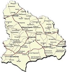
Nalgonda district
Encyclopedia

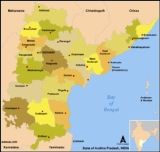
Andhra Pradesh
Andhra Pradesh , is one of the 28 states of India, situated on the southeastern coast of India. It is India's fourth largest state by area and fifth largest by population. Its capital and largest city by population is Hyderabad.The total GDP of Andhra Pradesh is $100 billion and is ranked third...
. It has a population of 3,483,648 of which 13.32% is urban
Urban area
An urban area is characterized by higher population density and vast human features in comparison to areas surrounding it. Urban areas may be cities, towns or conurbations, but the term is not commonly extended to rural settlements such as villages and hamlets.Urban areas are created and further...
as of 2001.
Etymology
Its name is derived from two TeluguTelugu language
Telugu is a Central Dravidian language primarily spoken in the state of Andhra Pradesh, India, where it is an official language. It is also spoken in the neighbouring states of Chattisgarh, Karnataka, Maharashtra, Orissa and Tamil Nadu...
words Nalla (Black) & Konda (Hills) i.e. Black Hills.
History
Nalgonda was earlier referred to as Neelagiri, the name given by some Rajput rulers and the name was changed to Nallagonda only after its conquest by Allauddin Bahaman Shah, a Bahamani king.Nalgonda District is currently a part of the Red Corridor
Red corridor
The Red Corridor is a term used to describe an impoverished region in the east of India that experiences considerable Naxalite communist insurgency...
.
Geography
Nalgonda district occupies an area of approximately 14200 square kilometres (5,482.7 sq mi), comparatively equivalent to IndonesiaIndonesia
Indonesia , officially the Republic of Indonesia , is a country in Southeast Asia and Oceania. Indonesia is an archipelago comprising approximately 13,000 islands. It has 33 provinces with over 238 million people, and is the world's fourth most populous country. Indonesia is a republic, with an...
's Flores
Flores
Flores is one of the Lesser Sunda Islands, an island arc with an estimated area of 14,300 km² extending east from the Java island of Indonesia. The population was 1.831.000 in the 2010 census and the largest town is Maumere. Flores is Portuguese for "flowers".Flores is located east of Sumbawa...
.
Towns in the district include: Nalgonda
Nalgonda
Nalgonda is a town and a municipality in Nalgonda district in the Indian state of Andhra Pradesh. Its name is derived from two Telugu words Nalla and Konda . Nalgonda in the past is referred to as Nilagiri. During the period of Bahamani kingdom, it had been renamed as Nallagonda...
, Miryalaguda, Suryapet
Suryapet
Suryapet is one of the major towns in Nalgonda district in India in the state of Andhra Pradesh. It is sometimes referred as Bhanupuri , it is equidistant from Hyderabad and Vijayawada. Suryapet is spread over an area of 134 km² and divided into 41 municipal wards as special grade municipality...
, Kodada, Chityal, Kattangur, Nakrekal
Nakrekal
Nakrekal is a Town and Mandal in the Nalgonda district in India and has a population of 50,000 as of 2010. It is located along the Indian National Highway No. 9, about 25km. from the district headquarters at the town of Nalgonda. Nakrekal has a significant influence on the villages surrounding it....
, Bhongir
Bhongir
Bhongir, Bhongiri or Bhuvanagiri is a Mondal and largest municipality in Nalgonda district, Andhra Pradesh, India. It is located in the of Bhongir, Bhongiri or Bhuvanagiri is a Mondal and largest municipality in Nalgonda district, Andhra Pradesh, India. It is located in the of Bhongir, Bhongiri or...
, Bhoodhan Pochampally
Bhoodhan Pochampally
Bhoodhan Pochampally is a Mandal in Nalgonda District. Nalgonda District, in turn is a district in Andhra Pradesh in southern India and is popularily known as Silk City of India.-Geography:Bhoodhan Pochampally is located at ,...
, Aleru, Narkatpalli, Huzurnagar
Huzurnagar
Huzurnagar is a town and taluka in Nalgonda district in the state of Andhra Pradesh in India.-Name:The town was originally named Ponucherla, in honor of the goddess Pochamma, but the name was changed to Huzurnagar when it was ruled by Huzur...
, Devarakonda
Devarakonda
Devarakonda is a census town and mandal headquarters in the Nalgonda district of the Indian state of Andhra Pradesh.- History :Devarakonda fort was a formidable stronghold of the Recherla velama Kings,this fort now stands amidst ruins. A place worth visiting by antiquity lovers it is no more than...
, Yadagirigutta, Rajapet
Rajapet
Rajapet is a historic location, popularly known as Samsthan Rajapet. The village is surrounded by a huge wall, or burj. Rajapet is the Mandal headquarters in Nalgonda district. It contains nineteen villages and two tandas. The main industries of the area are agriculture and textiles...
, Mothkur
Mothkur
Motkur or Mothkur is an agricultural and goods marketing town in the Nalgonda district, in the state of Andhra Pradesh, India.-Geography:...
, and Kanegal.
The rivers Krishna
Krishna River
The Krishna River , is one of the longest rivers in central-southern India, about . It is also referred to as Krishnaveni in its original nomenclature...
, Musi River
Musi River (India)
The Musi River is a tributary of Krishna River in the Deccan Plateau region of Andhra Pradesh state in India. It flows through a major portion of Hyderabad, India and divides the historic old city with the new city. Himayat Sagar and Osman Sagar is known as gandipet are the two dams built on it...
, Aleru, Peddavagu, Dindi
Dindi
"Dindi" is a song composed by Antonio Carlos Jobim, with lyrics by Aloysio de Oliveria. English lyrics were added by Ray Gilbert. Antonio Carlos Jobim wrote this piece especially for Brazilian singer Sylvia Telles whose nickname was Dindi...
and Paleru flow through the Nalgonda district.
Minerals in the district include Limestone
Limestone
Limestone is a sedimentary rock composed largely of the minerals calcite and aragonite, which are different crystal forms of calcium carbonate . Many limestones are composed from skeletal fragments of marine organisms such as coral or foraminifera....
, Black & Color Granites.
Clean drinking water, water supply for irrigation and educational facilities for all are perhaps the most important problems Nalgonda faces right now.
Nearly 500 villages in Nalgonda district are affected by the high fluorine
Fluorine
Fluorine is the chemical element with atomic number 9, represented by the symbol F. It is the lightest element of the halogen column of the periodic table and has a single stable isotope, fluorine-19. At standard pressure and temperature, fluorine is a pale yellow gas composed of diatomic...
content in water. It is estimated that nearly 1 million people are affected by Fluorosis
Fluorosis
Fluorosis can refer to:* Dental fluorosis* Skeletal fluorosisSkeletal fluorosis can be caused by: Cryolite ....
in Nalgonda district.
Parada village under Kattangur Mandal was suffering with drinking water in this mandal almost all villages supplied from Krishna but except this village.
Economy
In 2006 the Indian government named Nalgonda one of the country's 250 most backward districtsPoverty in India
Poverty is widespread in India, with the nation estimated to have a third of the world's poor. According to a 2005 World Bank estimate, 41.6% of the total Indian population falls below the international poverty line of 1.25 a day...
(out of a total of 640
Districts of India
A district is an administrative division of an Indian state or territory. Districts are further subdivided, in some cases into Sub-Divisions, and otherwise directly into tehsils or talukas.District officials include:...
). It is one of the thirteen districts in Andhra Pradesh currently receiving funds from the Backward Regions Grant Fund Programme (BRGF).
Agriculture
Irrigation projects- Nagarjuna Sagar
- Alimineti Madhava Reddy ProjectAlimineti Madhava Reddy ProjectAlimineti Madhava Reddy Project earlier known as Srisailam Left Bank Canal is a irrigation project located in Nalgonda district in Andhra Pradesh, India....
(previously known as the Srisailam Left Bank Canal)
Major crops
Major crops include Paddy
Rice
Rice is the seed of the monocot plants Oryza sativa or Oryza glaberrima . As a cereal grain, it is the most important staple food for a large part of the world's human population, especially in East Asia, Southeast Asia, South Asia, the Middle East, and the West Indies...
, Pulses, mousambi/Lime (fruit)
Lime (fruit)
Lime is a term referring to a number of different citrus fruits, both species and hybrids, which are typically round, green to yellow in color, 3–6 cm in diameter, and containing sour and acidic pulp. Limes are a good source of vitamin C. Limes are often used to accent the flavors of foods and...
, Millets & Oil Seeds.
Industry
Industries in the Nalgonda district are SilkSilk
Silk is a natural protein fiber, some forms of which can be woven into textiles. The best-known type of silk is obtained from the cocoons of the larvae of the mulberry silkworm Bombyx mori reared in captivity...
, Jaggery
Jaggery
Jaggery is a traditional unrefined non-centrifugal whole cane sugar consumed in Asia, Africa, Latin America, and the Caribbean. It is a concentrated product of cane juice without separation of the molasses and crystals, and can vary from golden brown to dark brown in color...
, Leather
Leather
Leather is a durable and flexible material created via the tanning of putrescible animal rawhide and skin, primarily cattlehide. It can be produced through different manufacturing processes, ranging from cottage industry to heavy industry.-Forms:...
, Cement
Cement
In the most general sense of the word, a cement is a binder, a substance that sets and hardens independently, and can bind other materials together. The word "cement" traces to the Romans, who used the term opus caementicium to describe masonry resembling modern concrete that was made from crushed...
factories, Pipe
Pipe
Pipe may refer to:* Pipe , a hollow cylinder following certain dimension rules* Smoking pipe* Pipe or butt, a cask measurement* Pipe , a type of metal casting defect...
s manufacturing & Cotton
Cotton
Cotton is a soft, fluffy staple fiber that grows in a boll, or protective capsule, around the seeds of cotton plants of the genus Gossypium. The fiber is almost pure cellulose. The botanical purpose of cotton fiber is to aid in seed dispersal....
,Rice Business(Rice Mills).
Mandals
| 1 Bommala Ramaram Bommala Ramaram Bommala Ramaram, shortly B. Ramaram is a Mandal in Nalgonda district of Andhra Pradesh, India.The villages in Bommala Ramaram mandal includes: B... |
2 Turkapally Turkapally Turkapally is a Mandal in Nalgonda district of Andhra Pradesh, India.The villages in Turka Pally mandal includes: Chinna Laxmapur, Dattaipally, Dharmaram, Gandamalla, Gollagudem, Gopalpur, Ibhrahimpur, Konapur, Kondapur, Thrukapally, Madhapur, Malkapur, Motiram Thanda, Mulka Pally, Nagai Pally,... |
3 Rajapet Rajapet Rajapet is a historic location, popularly known as Samsthan Rajapet. The village is surrounded by a huge wall, or burj. Rajapet is the Mandal headquarters in Nalgonda district. It contains nineteen villages and two tandas. The main industries of the area are agriculture and textiles... |
| 4 Yadagirigutta | 5 Alair | 6 Gundala Gundala, Nalgonda Gundala is a Mandal in Nalgonda district of Andhra Pradesh, India.The villages in Gundala mandal includes: Ambala, Anantharam, Bandakothapally, Brahmanpally, Gangapur, Gundala, Kommaipally, Marripadaga, Masanpally, Nunegudem, Pallepahad, Parupally, Pedda Padishala, Ramaram, Seetharampur, Suddala,... |
| 7 Tirumalagiri | 8 Thungathurthy Thungathurthy Thungathurthy is a historically important village in the district of Nalgonda. It was notable mainly for many social revolutions that have taken place during the 'Freedom movement' of India.... |
9 Noothankal Noothankal Noothankal or Nuthankal is a Mandal in Nalgonda district of Andhra Pradesh, India.The villages in Nuthankal mandal includes: Bikkumalla, Chandupatla, Chilpakuntla, Chinna Nemilla, Dirishanpally, G... |
| 10 Atmakur Atmakur, Nalgonda district -Villages:There are 32 villages in this mandal.* Chada* Chamapur* Chandepally* Duppelli* Pallerla* Pothireddypally* Kandagatla* Khapuraipally* Katepally* Kotapahad* Kondapur* Koratikal* Lingarajpally* Midhatana Palli* Modumaigudem* -Villages:... (S) |
11 Jajireddigudem Jajireddigudem Jajireddigudem is a Mandal in Nalgonda district of Andhra Pradesh, India.The villages in Jaji Reddi Gudem mandal includes: Adivemla, D. Kothapally, Jaji Reddy Gudem, Kesarla Pahad, Kodur, Kommala, Kunchamarthy, Loya Pally, Machireddy Pally, Nagaram, Persaipally, Thimmapur, Vardhamanukota etc.... |
12 Saligowraram |
| 13 Mothkur Mothkur Motkur or Mothkur is an agricultural and goods marketing town in the Nalgonda district, in the state of Andhra Pradesh, India.-Geography:... |
14 Atmakur (M) | 15 Valigonda Valigonda Valigonda is a Mandal in Nalgonda district, Andhra Pradesh, India. It is located on the banks of Musi River.-Geography:Valigonda is located at . It has an average elevation of 291 metres .-Eminent persons:* V... |
| 16 Bhongir Bhongir Bhongir, Bhongiri or Bhuvanagiri is a Mondal and largest municipality in Nalgonda district, Andhra Pradesh, India. It is located in the of Bhongir, Bhongiri or Bhuvanagiri is a Mondal and largest municipality in Nalgonda district, Andhra Pradesh, India. It is located in the of Bhongir, Bhongiri or... |
17 Bibinagar Bibinagar Bibinagar is a mandal headquarter in Nalgonda district, Andhra Pradesh, India. It is located on Warangal Highway between Hyderabad and Bhongir.-Commercial area:... |
18 Pochampally Bhoodhan Pochampally Bhoodhan Pochampally is a Mandal in Nalgonda District. Nalgonda District, in turn is a district in Andhra Pradesh in southern India and is popularily known as Silk City of India.-Geography:Bhoodhan Pochampally is located at ,... |
| 19 Choutuppal Choutuppal Choutuppal is a census town and mandal headquarters in Nalgonda district in the state of Andhra Pradesh, India.-Demographics: India census, Choutuppal had a population of 14,071. Males constitute 50% of the population and females 50%. Choutuppal has an average literacy rate of 65%, higher than the... |
20 Ramannapeta Ramannapeta -Geography:Ramanapeta is located at . It has an average elevation of 304 metres .-Villages:The villages in Ramannapeta mandal include* Bogaram * Dubbaka * Ennaram * Thummalagudem * Iskilla * Janampally * Kakkireni * Kunkudupamula... |
21 Chityal |
| 22 Narketpally Narketpally Narketpally is a village and mandal located along National Highway 9 in Nalgonda district of Andhra Pradesh, India. It lies on National Highway 9 between Chityal and Kattangoor in Nalgonda district. It is the fastest growing village/town in A.P... |
23 Kattangur | 24 Nakrekal Nakrekal Nakrekal is a Town and Mandal in the Nalgonda district in India and has a population of 50,000 as of 2010. It is located along the Indian National Highway No. 9, about 25km. from the district headquarters at the town of Nalgonda. Nakrekal has a significant influence on the villages surrounding it.... |
| 25 Kethepally Kethepally Kethepally is a Town and Mandal in the Nalgonda district in India. It is located along the National Highway No. 9, about 30 km from the district headquarters Nalgonda.... |
26 Suryapet Suryapet Suryapet is one of the major towns in Nalgonda district in India in the state of Andhra Pradesh. It is sometimes referred as Bhanupuri , it is equidistant from Hyderabad and Vijayawada. Suryapet is spread over an area of 134 km² and divided into 41 municipal wards as special grade municipality... |
27 Chivemla |
| 28 Mothey Mothey -Geography:Moteh is located at . It has an average elevation of 237 metres .Villages:#Raghavapuram#Thummagudem#Narsimhapuram#Urlagonda#Mamillagudeam#Kothagudem#Thummalapalli#Vibhalaapuram#Rampuram Thanda#Hussainabad#Namavaram#sirikonda... |
29 Nadigudem Nadigudem Nadigudem is a village and Gram panchayat of Nalgonda mandal, Nalgonda district, in Andhra Pradesh state.-References:It is a mandal serving the facilities of sorrounding villages like karivirala,Ramachandrapuram, Sigaram, Tellabelli, Brundavana puram, Siripuram, Chanupalli, Sree Ranga Puram,... |
30 Munagala Munagala Munagala is a town and mandal in the Nalgonda district in the state of Andhra Pradesh, India.It is Located on National Highway 9 and there are many small villages besides this town. Even though NH9 highway passes through it, still it is under developed. The nearest big towns are Kodada and... |
| 31 Penpahad Penpahad -Villages:The villages in Penpahad includes Anajipuram, Anantharam, Bhakthala Puram, Cheedella, Dharmapuram, Doophad, Dosa Pahad, Gajula Mallkapoor,... |
32 Vemulapally Vemulapally -Villages:The villages in Vemulapally mandal includes:* Agamothkur * Amangal * Annapureddy Gudem * Bheemana Pally * Bommakal * Chirumarthy * Gurrappa Gudem * Kalvala Palem* Kamepally * Kukkadam * Molkapatnam * Pamula Pahad * Poreddy Gudem... |
33 Thipparthy Thipparthy Tipparti, Thipparthi or Thipparthy is a historical village in the Nalgonda district in Andhra Pradesh. Thipparthy is located 18 kilometers away from the District Head Quarters of Nalgonda, 24 kilometers away from Miryalguda, and 120 kilometers away from the state capital of Hyderabad. It is near... |
| 34 Nalgonda Nalgonda Nalgonda is a town and a municipality in Nalgonda district in the Indian state of Andhra Pradesh. Its name is derived from two Telugu words Nalla and Konda . Nalgonda in the past is referred to as Nilagiri. During the period of Bahamani kingdom, it had been renamed as Nallagonda... |
35 Munugode Munugode Mungode or Munugode is a Mandal in Nalgonda district of Andhra Pradesh, India.Munugode is also an Assembly constituency in Andhra Pradesh Legislative Assembly.-Geography:Mungode is located at... |
36 Narayanapur Narayanapur, Nalgonda Narayanpur or Narayanapur is a Mandal in Nalgonda district, Andhra Pradesh, India.-Geography:Narayanpur is located at . It has an average elevation of 349 metres .-Demographics:... |
| 37 Marriguda Marriguda Marriguda is Mandal head quarters in Nalgonda district of Andhra Pradesh, India.- Villages in Marriguda Mandal :There are 17 villages in this Mandal.# Anthampet# Bhatla Palle# Damera Bheeman Palle# Indurthi# Khudabaksh Palle# Kondur# Lenkala Palle... |
38 Chandur Chandur, Andhra Pradesh Chandur is a census town in Nalgonda district in the state of Andhra Pradesh, India.-Geography:Chandur is located at . It has an average elevation of 484 metres .-Demographics:... |
39 Kanagal Kanagal, Nalgonda Kanagal is a Mandal in Nalgonda district of Andhra Pradesh, India.The villages in Kanagal mandal includes: Bachannagudem, Boinapally, Cherla Gouraram, Chetla Chennaram, China Madaram, Dhareshpoor, Dorepally, G. Chennaram, G. Yadavally, Kanagal, Kurampally, Lachugudem, Pagidemarry, Parvatagiri,... |
| 40 Nidamanoor | 41 Tripuraram Tripuraram Tripuraram is a village and Gram panchayat of Nalgonda mandal, Nalgonda district, in Andhra Pradesh state.... |
42 Miryalaguda |
| 43 Garidepally | 44 Chilkur Chilkur, Nalgonda district -Villages:Villages in Chilkur mandal include: Acharlagudem, Arlagudem, Bethavole, Chennarigudem, Chilkur, Janakinagar, Jerripotula Gudem, Kondapuram, Narayanapuram, Polenigudem, Ramapuram, Sethala Thanda, and Setharamapuram.... |
45 Kodad Kodad Kodad or Kodada is a town and Mandal headquarters in the Nalgonda district of Andhra Pradesh, South India. It lies on the National Highway 9 between Hyderabad and Vijayawada.... |
| 46 Mellachervu Mellachervu MellaCheruvu also known as Medlacheruru or MellaCheruvu is a village in Nalgonda district of Andhra Pradesh, India, situated at a distance of 10 km from Huzur Nagar and 24 km from Kodad and 68 km from the Khammam railway station... |
47 Huzurnagar Huzurnagar Huzurnagar is a town and taluka in Nalgonda district in the state of Andhra Pradesh in India.-Name:The town was originally named Ponucherla, in honor of the goddess Pochamma, but the name was changed to Huzurnagar when it was ruled by Huzur... |
48 Mattampally Mattampally Mattampally is a mandal in the Nalgonda district, Andhra Pradesh, India, located from Hyderabad, 13 km from the banks of the Krishna River.- Education :... |
| 49 Neredcherla Neredcherla Neredcherla is a Mandal in Nalgonda district of Andhra Pradesh, India. Needucherla is the third largest mandal in the state of Andhra pradesh.-Institutes:* Zilla Parishad High SchoolKranthi Public SchoolPragathi High SchoolLittle Flower School... |
50 Damercherla | 51 Anumula Anumula -Villages:The villages in Anumula mandal include:* Alwala * Annaram * Anumula * Boyagudem * Chelmareddygudem * Garikeneti Thanda * Hazariguda * Ibrahimpet* Kompally * Korvanigudem * Kothapally * Marepally * Naidupalem * Palem... |
| 52 Peddavoora Peddavoora Peddavura or Peddavoora is a Mandal in Nalgonda district of Andhra Pradesh, India.The villages in Peddavura mandal includes: Chalakurthy, Chintalapalem, Kothalur, Nellikal, Parvedula, Peddavoora, Pinnavoora, Pothnur, Pulicherla, Sirsanagandla, Theppalamadugu, Thungathurthy, Thunikinuthala,... |
53 P.A.Pally | 54 Gurrampode Gurrampode Gurrampod, Gurrampode, or Gurampod, is a village and mandal headquarters in the Nalgonda district in the state of Andhra Pradesh, India. It is 30 km from Nalgonda town.-Geography:... |
| 55 Nampally Nampally, Nalgonda Nampally is a mandal in Nalgonda district of Andhra Pradesh, India.- Villages :The villages in Nampally mandal include Banda Thimmapoor, Chamalapally, Chittempad, Damera, Devathpally, G. Mallepally, Mahamadapur, Mallapurajpally, Mellavai, Mustipally, Nampally, Narsimhuluguda, Nerellapally,... |
56 Chintapally | 57 Devarakonda Devarakonda Devarakonda is a census town and mandal headquarters in the Nalgonda district of the Indian state of Andhra Pradesh.- History :Devarakonda fort was a formidable stronghold of the Recherla velama Kings,this fort now stands amidst ruins. A place worth visiting by antiquity lovers it is no more than... |
| 58 Gundlapally Gundlapally Gundlapally or Gundlapalli is a Mandal in Nalgonda district of Andhra Pradesh, India.The villages in Gundlapally mandal includes: Bogguladonna,gonakol, Bolnepally, Cherkupally, Dasarinemalipur, Gonaboinapally, Gundlapally, Kamepally, Kandukur, Khanapur, Rahmanthpur, Singarajpally, T. Gouraram,... |
59 Chandampet Chandampet -Villages:The villages in Chandampet mandal includes: Bachapuram, Chandempet, Chinamunagal, Chitryala, Gagillapuram, Kambalapally, Kasharajupally, Kothapally, Mududandla, Murpunutala, Neradugommu, Peddamula, Peddamunagal, Pogilla, Polepally Ramnagar, Rakulagadda, Teldevarapally, Timmapuram,... |
- Gram panchayats under Nalgonda mandalGram panchayats under Nalgonda mandalNalgonda mandal is divided into 50 Gram panchayats for ease of administration and to take government closer to the people.-Gram panchayats of Nagonda mandal:# Anantharam Nlg# Annareddygudem Nlg# Anneparthy # Appajipeta # Arjalabai...
is a total of 1178
Suryapet
Suryapet
Suryapet is one of the major towns in Nalgonda district in India in the state of Andhra Pradesh. It is sometimes referred as Bhanupuri , it is equidistant from Hyderabad and Vijayawada. Suryapet is spread over an area of 134 km² and divided into 41 municipal wards as special grade municipality...
Household indicators
In 2007–2008 the International Institute for Population Sciences interviewed 1236 households in 43 villages across the district. They found that 90.4% had access to electricity, 97% had drinking waterWater supply and sanitation in India
Water supply and sanitation in India continue to be inadequate, despite longstanding efforts by the various levels of government and communities at improving coverage. The level of investment in water and sanitation, albeit low by international standards, has increased during the 2000s. Access has...
, 29.1% toilet facilities, and 45.1% lived in a pucca
Pucca housing
Pucca housing refers to dwellings that are designed to be solid and permanent. The term is applied to housing in South Asia built of substantial material such as stone, brick, cement, concrete, or timber....
(permanent) home
Housing in India
Housing in India varies greatly and reflects the socio-economic mix of its vast population.Housing varies from palaces of erstwhile maharajas in Rajasthan to swanky apartment buildings in big cities to tiny huts in far-flung villages...
. 37.5% of girls wed before the legal age
Marriageable age
Marriageable age is the age at which a person is allowed to marry, either as of right or subject to parental or other forms of consent. The age and other requirements vary between countries, but generally it is set at 18, although most jurisdictions allow marriage at slightly younger ages with...
of 18 and 87% of interviewees carried a BPL
Below Poverty Line
Below Poverty Line is an economic benchmark and poverty threshold used by the government of India to indicate economic disadvantage and to identify individuals and households in need of government assistance and aid. It is determined using various parameters which vary from state to state and...
card.
Demographics
According to the 2011 census2011 census of India
The 15th Indian National census was conducted in two phases, houselisting and population enumeration. Houselisting phase began on April 1, 2010 and involved collection of information about all buildings...
Nalgonda district has a population
Demographics of India
The demographics of India are inclusive of the second most populous country in the world, with over 1.21 billion people , more than a sixth of the world's population. Already containing 17.5% of the world's population, India is projected to be the world's most populous country by 2025, surpassing...
of 3,483,648 , roughly equal to the nation of Panama
Panama
Panama , officially the Republic of Panama , is the southernmost country of Central America. Situated on the isthmus connecting North and South America, it is bordered by Costa Rica to the northwest, Colombia to the southeast, the Caribbean Sea to the north and the Pacific Ocean to the south. The...
or the US state of Connecticut
Connecticut
Connecticut is a state in the New England region of the northeastern United States. It is bordered by Rhode Island to the east, Massachusetts to the north, and the state of New York to the west and the south .Connecticut is named for the Connecticut River, the major U.S. river that approximately...
. This gives it a ranking of 88th in India (out of a total of 640
Districts of India
A district is an administrative division of an Indian state or territory. Districts are further subdivided, in some cases into Sub-Divisions, and otherwise directly into tehsils or talukas.District officials include:...
). The district has a population density of 245 PD/sqkm . Its population growth rate
Family planning in India
Family planning in India is based on efforts largely sponsored by the Indian government. In the 1965-2009 period, contraceptive usage has more than tripled and the fertility rate has more than halved , but the national fertility rate is still high enough to cause long-term population growth...
over the decade 2001-2011 was 7.26 %. Nalgonda has a sex ratio
Sex ratio
Sex ratio is the ratio of males to females in a population. The primary sex ratio is the ratio at the time of conception, secondary sex ratio is the ratio at time of birth, and tertiary sex ratio is the ratio of mature organisms....
of 982 females
Women in India
The status of women in India has been subject to many great changes over the past few millennia. From equal status with men in ancient times through the low points of the medieval period, to the promotion of equal rights by many reformers, the history of women in India has been eventful...
for every 1000 males, and a literacy rate
Literacy in India
Literacy in India is key for socio-economic progress, and the Indian literacy rate grew to 74.04% in 2011 from 12% at the end of British rule in 1947. Although this was a greater than sixfold improvement, the level is well below the world average literacy rate of 84%, and India currently has the...
of 65.05 %.