

Mandi district
Encyclopedia
Himachal Pradesh
Himachal Pradesh is a state in Northern India. It is spread over , and is bordered by the Indian states of Jammu and Kashmir on the north, Punjab on the west and south-west, Haryana and Uttar Pradesh on the south, Uttarakhand on the south-east and by the Tibet Autonomous Region on the east...
state in northern India
India
India , officially the Republic of India , is a country in South Asia. It is the seventh-largest country by geographical area, the second-most populous country with over 1.2 billion people, and the most populous democracy in the world...
. Mandi town is the headquarters of Mandi district Mandi. The town has both mythological and historical significance and boasts of a unique temple architecture. It is also referred to as Chhota Kashi as there are many ancient temples in the city and on the banks of river Beas. The river Beas flows through the town and hills, which makes this town more scenic. It has a serene ambiance though the modern development has made its inroads here in terms of infrastructural developments.
The town is an important commercial hub of the state. It is a major transit route to Kullu-Manali and other adjoining places from both NH-21 (Chandigarh-Manali highway) and NH-20 (Pathankot-Mandi highway).
Sundarnagar
Sundarnagar
Sunder Nagar is a place in Mandi City and a municipal council in Mandi district in the Indian state of Himachal Pradesh. Formerly it was a princely state, known as Suket.-Geography:Sunder Nagar is located at...
is one of the emerging towns of the district.
Mandi has an educated middle class and people converse in Mandyali, one of the Pahari languages
Pahari languages
The Pahari languages are a geographic group of Indic languages spoken in the lower ranges of the Himalayas, from Nepal in the east to the Indian states of Uttarakhand, Himachal Pradesh and Jammu and Kashmir in the west.-Classification:The Pahari languages fall into three groups:*Eastern, consisting...
of Himachal.
As of 2011 it is the second most populous district of Himachal Pradesh (out of 12), after Kangra
Kangra district
Kangra is the most populous district of the state of Himachal Pradesh, India. Dharamsala is the administrative headquarters of the district.-Geography:Kangra district of Himachal Pradesh is situated in Western Himalayas between 31°2 to...
.
History
Mandi district was formed after the merger of Mandi StateMandi State
Mandi State was a princely state of India before 1947....
(Mandi) and Suket
Suket
Suket is a census town in Kota district in the Indian state of Rajasthan.-Geography:Suket is located at . It has an average elevation of 320 metres .-Demographics:...
, two princely state
Princely state
A Princely State was a nominally sovereign entitity of British rule in India that was not directly governed by the British, but rather by an Indian ruler under a form of indirect rule such as suzerainty or paramountcy.-British relationship with the Princely States:India under the British Raj ...
s on 15 April 1948. This coincided with the formation of the Union territory of Himachal Pradesh. It is to be mentioned that the state attained its full statehood later. Mandi town was named after its resident saint Mandavya Rishi. Mandi is situated almost at the geographical centre of Himachal, lying along the left bank of the river Beas in the foothills of Shivalik ranges. The town of Mandi has an altitude of 760 metres (2,495 ft) from the sea level. Comprising the two erstwhile states of Mandi and Suket, Mandi derives its name 'mandi' or 'market' as it was a major trade route from Ladhakh to various locations in Punjab such as Hoshiarpur and other places. Here, during the days of yore, the pious rishi, Mandavaya, performed long and severe penance and practised austerities on his body, on the bank of the river Beas, near the present Mandi town.The story indicates towards the antiquity of this beautiful temple town,surrounded by hills, clad in pines. There is a large plain which has grain fields and orchards, between Mandi and Sundernagar. Known for its temples, Mandi is the home to a number of beautiful carved stone edifices each with an elaborate shikhara, or spire, among them Bhutnath, Trilokinath, Panchvaktra and Shyamakoli at Tarna hill. Also on the hill, there is a new temple dedicated to Tarna Devi, overlooking the valley and giving a panoramic view of the whole area. The Beas valley is broad near Mandi, but there are a number of striking vales such as those of Uhl and Ran Khad. The area fruit tree cover in Mandi is about 15 per cent of the total area under fruit tree cover in Himachal Pradesh. Mandi raw-silk has acquired wide fame and the rock salt mines at Drang and Guma are also the special features of the district economy. With abundant deposit of rock salt and lime-stone, possibilities are being investigated for the existence of magnasite coal and china-clay. A transit for visitors to Kullu, Manali, Lahaul and Spiti, Dharamsala, Kangra, etc., it is approachable from Pathankot (215 km or 132 mile), Chandigarh (202 or 125 miles) and Shimla (158 or 98 miles). On either side of the road, there are rock hill sides rising perpendicularly to more than 300 metres (1,000 ft).
General information
- Area: 3950 km2
- Population: 901000
- Clothing: Cotton clothes in summer and woollen to heavy woollen in winter.
- Language: HindiHindiStandard Hindi, or more precisely Modern Standard Hindi, also known as Manak Hindi , High Hindi, Nagari Hindi, and Literary Hindi, is a standardized and sanskritized register of the Hindustani language derived from the Khariboli dialect of Delhi...
, EnglishEnglish languageEnglish is a West Germanic language that arose in the Anglo-Saxon kingdoms of England and spread into what was to become south-east Scotland under the influence of the Anglian medieval kingdom of Northumbria...
, PahariPahari languagesThe Pahari languages are a geographic group of Indic languages spoken in the lower ranges of the Himalayas, from Nepal in the east to the Indian states of Uttarakhand, Himachal Pradesh and Jammu and Kashmir in the west.-Classification:The Pahari languages fall into three groups:*Eastern, consisting...
and Mandyali are understood and spoken by the people engaged in tourism trade. - Divisions: Divided into nine tehsils and seven sub-tehsil; Kharsog, Chachyot, Mandi Sadar Sundar Nagar[padhar] [lad bharol] [thunag] {sarkaghat] jogindernagarJogindernagarJoginder Nagar or Jogindar Nagar is a town and a nagar panchayat in Mandi district in the Indian state of Himachal Pradesh. Named after Raja Joginder Sen, Joginder Nagar is terminal point of 163 km long Kangra Valley Narrow gauge railhead...
(sub-tehsil kotali) autAUTAUT may refer to:- Autriche - Österreich*The IATA airport code for the airport in Atauro, Indonesia.*The ISO 3166-1 3-letter country code for Austria-Other uses:In education:*Amirkabir University of Technology, Iran...
nihariNihariNihari is a popular meat dish of Pakistanis of South Asia. Its roots lie in the Nawab kitchens having achieved fame via the storied royal kitchens of Lucknow in present-day Uttar Pradesh, long the seat of the Nawab of Avadh and is also relished in India by Muslims and non-Muslim foodies...
[balichowki] [sandhol] [dharampur] [baldwara] ]
Approach
- Train: The nearest railway stations are Joginder Nagar and ShimlaShimlaShimla , formerly known as Simla, is the capital city of Himachal Pradesh. In 1864, Shimla was declared the summer capital of the British Raj in India. A popular tourist destination, Shimla is often referred to as the "Queen of Hills," a term coined by the British...
by narrow gauge train, ChandigarhChandigarhChandigarh is a union territory of India that serves as the capital of two states, Haryana and Punjab. The name Chandigarh translates as "The Fort of Chandi". The name is from an ancient temple called Chandi Mandir, devoted to the Hindu goddess Chandi, in the city...
and KalkaKalkaKalka is a town in the Panchkula district of Haryana, India. The name of the town is derived from the goddess Kali. The town is situated in the foothills of the Himalayas and is a gateway to the neighbouring state of Himachal Pradesh. It is on the National Highway 22 between Chandigarh and Shimla,...
by broad gauge train which are connected by regular bus services. - Road: Mandi is approachable by road from Shimla, Chandigarh, PathankotPathankotPathankot became 22nd district on 28th July 2011 and a municipal corporation in the Indian state of Punjab. It was a part of the Nurpur princely state ruled by the Rajputs prior to 1849 AD. It is a meeting point of the three northern states of Punjab, Himachal Pradesh and Jammu and Kashmir...
and DelhiDelhiDelhi , officially National Capital Territory of Delhi , is the largest metropolis by area and the second-largest by population in India, next to Mumbai. It is the eighth largest metropolis in the world by population with 16,753,265 inhabitants in the Territory at the 2011 Census...
. There are regular bus services linking it to the other towns like Manali, PalampurPalampurPalampur is a green hill station and a municipal council in the Kangra Valley in the Indian state of Himachal Pradesh, surrounded on all sides by tea gardens and pine forests before they merge with the Dhauladhar ranges. Palampur is the tea capital of northwest India but tea is just one aspect that...
and Dharamshala. - Airplane: The nearest airport is at Bhuntar in Kullu District, about 50 km from the district.
Mandi Tourism
The historic town of Mandi (800 M) is built along the banks of the river Beas. It has long been an important commercial centre, and the sage Mandvya is said to have meditated here. This one time capital of the princely state of Mandi is a fast developing town that still retains much of its original charm and character. Today, it is a district headquarters. Mandi is renowned for its 81 old stone temples and their enormous range of fine carving. Because of this, it is often called the "Varanasi of the Hills`. The town also has the remains of old palaces and notable examples of ‘colonial’ architecture. Mandi is the gateway to the Kullu valley and acts as the base for several exciting excursions.Bhootnath Temple Practically synonymous with Mandi and located in its very heart, this is as old as the town itself, and dates back to the 1520s. In March, the festival of Shivratri is a major event and the Bhootnath temple is its focus. For and entire week the town celebrates the arrival of hundreds of local deities on elaborately decorated palanquins.
Getting There
By Air
The closest airport from Mandi is Bhuntar, which is around 59 kilometers away in Kulu district.
By Rail
The closest railhead is in Kiratpur which 125 kilometers away from the town of Mandi.
'By Road'
Mandi is connected to Chandigarh by National Highway 21. The distance between Mandi & Chandigarh is 200 kilometers. Government buses are available throughout the day to Chandigarh. It takes about 5–6 hours to commute to Chandigarh by bus and around 3–4 hours if a private vehicle is taken. Mandi is also connected to Shimla, the capital of Himachal Pradesh. The distance between Shimla & Mandi is about 147 kilometers. The total time taken to commute between Shimla & Mandi is about 5 hour.
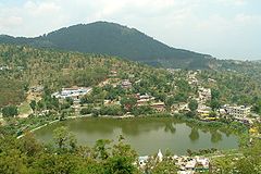
Rewalsar Lake
About 25 km from Mandi, 14 km from Ner Chowk is the Rewalsar lakeRewalsar Lake
Located on a mountain spur, 12 miles or about an hour's drive from Mandi brings you to this dark jewel-like lake. With water, woodland and high hills, it presents a variety of natural beauty. The spot is sacred for Hindus, Buddhists and Sikhs. It is about 4,000 feet above sea level.There are...
, famous for its floating islands of reed. It is believed that all seven of them can be moved by prayer or breeze. There are three shrines here, a Buddhist Monastery, where elaborate rituals are performed, a Sikh Gurudwara and a Hindu Temple. It was from this place that the sage Padma Sambhava, a zealous teacher of Buddhism, left as a missionary to preach the doctrine of "the enlightened" in Tibet. Lying in a mountain hollow, the lake is held sacred to all three communities, boating facilities are available. Tourist inn maintained by HPTDC provide accommodation and Indian cuisine.
Prashar Lake
Prashar LakePrashar Lake
Prashar Lake lies 49 km north of Mandi, with a three storied pagoda-like temple dedicated to the sage Prashar. The Lake is located at a height of 2730 m above sea level. With deep blue waters, the lake is held sacred to the sage Prashar and he is regarded to have meditated there...
lies 49 km north of Mandi, with a three storied pagoda like temple dedicated to the sage Prashar.
Joginder Nagar
The large hydro-electric project in Joginder Nagar has an electric trolley takes the visitor up the steep, rocky face of 2,500 metres-high (8,202 ft) mountain and drops sharply on the other side to Barot, where the reservoir is located.The railway line goes up to the power station, the water rushing down from the reservoir at Barot in the Uhl river
Uhl River
Uhl is a Himalayan stream which is part of the watershed of Beas river. The river originates at the Thamsar Glacier in the Dhauladhar range of the Himalayas, flows through the Uhl valley crossing Bada Gran and Barot, both villages in the Uhl valley. In the lower part of its course, it is also known...
through penstock pipes going down nearly a thousand metres (3,280 ft). For tourists who go up to Barot by the trolley, there is a comfortable rest house of the Electricity department. The roads extend beyond to Mandi and passes the Larji gorge to the Kullu
Kullu
Kullu, once known as Kul-anti-peetha - "the end of the habitable world", is the capital town of the Kullu District, in the state of Himachal Pradesh, India. It is located on the banks of the Beas River in the Kullu Valley about ten kilometres north of the airport at Bhuntar.Kullu is a broad open...
valley.
Bassi power station is five kilometres from Jogindernagar and next to it, is Machhial where fishing is not permitted as it is considered a holy sacred spot, but it is a popular as a feeding spot for fish.
ladh-bharol 25 km from joginder nagar very beautiful town,santan datri ma simsa mata mandir situated in near lad-bharol,7 km from ladh-bharol,nageshwar mahadev coudh is also situated in near bharol whre very strane gufa in near shiv mandir.
Sunder Nagar
Famous for its temples, 26 km from Mandi towards Shimla and at a height of 1,174 metres on the raised edge of a fertile valley, the beautiful town of Sunder NagarSunder Nagar
Sunder Nagar is a neighbourhood in the suburb of Malad–Goregaon in Mumbai, India. It lies east of the arterial Swami Vivekanand Road and is mostly a residential neighbourhood. It was built up in the 1970s during the city's population and construction boom. The name Sunder Nagar means...
is known for its shady walks amidst towering trees. On top of a hill and visited by thousands of devotees every year, is the Sukhdev Vatika and temple of Mahamaya.
The biggest hydro-electric project in all Asia
Asia
Asia is the world's largest and most populous continent, located primarily in the eastern and northern hemispheres. It covers 8.7% of the Earth's total surface area and with approximately 3.879 billion people, it hosts 60% of the world's current human population...
, the Beas-Sutlej project, irrigating nearly one-fourth of the northern plains of India, has brought unprecedented prosperity to Sunder Nagar. The Beas-Sutlej link colony is the biggest colony in Himachal Pradesh.
Janjehli
At a distance of 80 km from Mandi, Janjehli is a paradise for hikers, offering treks up to a height of 3,300 metres. After covering 32 km by a motorable road up to Gohar and rest of the journey is on foot. In the midst of thick forest, forests (15 km from Gohar) is Bajahi. There is a beautiful and well furnished rest house to stay overnight, from here Janjehli is a scant 20 km away through bridle path. Chindi and Karsog are also nice places for meditation. Janlehli is also popular for adventure activities like-trekking, night safari, mountneering, skiing etc. At the distance of 10 km from janjehli the Shikari Mata temple is situated.The temple is all about Goddess "Shikari Devi" and people visits here in masses to accolades for their well being.Its a beautiful and scenariatic place with mountains seems to avoiding each other but the clouds more often use to get them in touch.
Kotli(Tungal)-At a distance of 22 km from mandi(Mandi-Jalandhar NH-70)Famous temples:- Shiv temple Kotli,Racehra dev temple kotli And Racehra hill, Janitri devi Temple at Janitri Hill,Jhagru Dev Temple,Kasla dev and kamrawh dev temple kotli, surgani devi temple,Mahan dev temple Tej bahadur singh Temple,troka wali devi temple,Nagni devi temple etc. are very Famous.
Road:-1.Mandi Jalandhar NH-70 22 km by jail Road, Talyahr.
2. Mandi Kotli 25 km By Hospital Road, bir saigaloo.
3. jogindarnagar-Kotli 44 km By machyali, manaroo, kun ka tar.
4.dharmpur kotli 35 km by mandap baroti.
Lakes of Mandi district
- KotliKotliKotli is the chief town of Kotli District, in the Pakistani-administered Azad Jammu and Kashmir. Kotli is linked with Mirpur by two metalled roads, one via Rajdhani, and the other via Charhoi...
- Bir TungalBir TungalBir Tungal is a hill area situated approximately 10 km from the Mandi Town. Mandi is the central district of Himachal Pradesh, India.It has a middle class population dependant on agriculture, government and other private jobs. There are about 5000 and 95% of them are educated people. Bir,...
- Nalhog
- Baryara
- Rewalsar LakeRewalsar LakeLocated on a mountain spur, 12 miles or about an hour's drive from Mandi brings you to this dark jewel-like lake. With water, woodland and high hills, it presents a variety of natural beauty. The spot is sacred for Hindus, Buddhists and Sikhs. It is about 4,000 feet above sea level.There are...
- Prashar LakePrashar LakePrashar Lake lies 49 km north of Mandi, with a three storied pagoda-like temple dedicated to the sage Prashar. The Lake is located at a height of 2730 m above sea level. With deep blue waters, the lake is held sacred to the sage Prashar and he is regarded to have meditated there...
- Macchial LakeMacchial LakeMacchial Lake is a low altitude lake which is situated in Mandi district . This lake is considered sacred and is named after Macchendru Devta or Matasya Avtar of Lord Vishnu....
- Shiv Shambhu Lake
Demographics
According to the 2011 census2011 census of India
The 15th Indian National census was conducted in two phases, houselisting and population enumeration. Houselisting phase began on April 1, 2010 and involved collection of information about all buildings...
Mandi district has a population
Demographics of India
The demographics of India are inclusive of the second most populous country in the world, with over 1.21 billion people , more than a sixth of the world's population. Already containing 17.5% of the world's population, India is projected to be the world's most populous country by 2025, surpassing...
of 999,518, roughly equal to the nation of Fiji
Fiji
Fiji , officially the Republic of Fiji , is an island nation in Melanesia in the South Pacific Ocean about northeast of New Zealand's North Island...
or the US state of Montana
Montana
Montana is a state in the Western United States. The western third of Montana contains numerous mountain ranges. Smaller, "island ranges" are found in the central third of the state, for a total of 77 named ranges of the Rocky Mountains. This geographical fact is reflected in the state's name,...
. This gives it a ranking of 446th in India (out of a total of 640
Districts of India
A district is an administrative division of an Indian state or territory. Districts are further subdivided, in some cases into Sub-Divisions, and otherwise directly into tehsils or talukas.District officials include:...
).
The district has a population density of 253 PD/sqkm . Its population growth rate
Family planning in India
Family planning in India is based on efforts largely sponsored by the Indian government. In the 1965-2009 period, contraceptive usage has more than tripled and the fertility rate has more than halved , but the national fertility rate is still high enough to cause long-term population growth...
over the decade 2001-2011 was 10.89 %. Mandi has a sex ratio
Sex ratio
Sex ratio is the ratio of males to females in a population. The primary sex ratio is the ratio at the time of conception, secondary sex ratio is the ratio at time of birth, and tertiary sex ratio is the ratio of mature organisms....
of 1012 females
Women in India
The status of women in India has been subject to many great changes over the past few millennia. From equal status with men in ancient times through the low points of the medieval period, to the promotion of equal rights by many reformers, the history of women in India has been eventful...
for every 1000 males, and a literacy rate
Literacy in India
Literacy in India is key for socio-economic progress, and the Indian literacy rate grew to 74.04% in 2011 from 12% at the end of British rule in 1947. Although this was a greater than sixfold improvement, the level is well below the world average literacy rate of 84%, and India currently has the...
of 82.81 %.
Sports
The district is home to the BandyBandy
Bandy is a team winter sport played on ice, in which skaters use sticks to direct a ball into the opposing team's goal.The rules of the game have many similarities to those of association football: the game is played on a rectangle of ice the same size as a football field. Each team has 11 players,...
Federation of India which is a member of the IOC recognized Federation of International Bandy. BFI plan to send a team to the 2011 Asian Winter Games. That will be the 1st time India participates in a bandy competition.