

Highways in Australia
Encyclopedia
This is a list of highway
s in Australia
, listed alphabetically along with each highway's route number and location. Note that some highways service more than one state or territory.
in each State. These highways link major country towns to the capital cities. Intercapital transport was initially mainly by sea and rail.
As the population increased, roads connecting the towns located on different highways were constructed. Victoria, for example, has the largest highway network, with every major town linked directly to every other major town in the state. Increased demand for freight and passenger transport led to construction of intercity highways, although much freight still goes by rail.
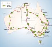

 In 1955, the Australian National Route Numbering System was introduced to simplify navigation across Australia. The National Route Numbers are marked by white shields that are present in directional signs, distance signs or trailblazers. The general rule is that odd-numbered highways travel in north-south directions and even-numbered highways in east-west directions, with only a few exceptions. National Route 1
was assigned to a network of highways and roads, which together linked all capital cities and coastal towns circumnavigating the mainland.
In the 1970s the National Highway scheme was introduced. These highways are federally funded. They are recognised by their distinct green and gold shields.
The National Route system initially linked the centres of towns and cities and terminated at the junction of other national routes. The growth of bypasses around towns and cities changes the situation somewhat. National Routes often terminate at the metropolitan city limits rather than the individual city centres.
In New South Wales
, they are also adopted in metropolitan areas of Wollongong and Newcastle
using three-digit numbers instead of two-digit found elsewhere. In regional Victoria
and South Australia
, the blue shield state route numbers were superseded in the late 1990s with the alphanumeric system, which is also used in Tasmania. See below.
Unlike many other countries, most highways in Australia have names in addition to numbers, and they tend to be most widely referred to by those names, rather than code numbers, by the public.

 In the 1990s there was a major change to the route marking systems. Victoria
and South Australia
had completely overhauled their systems. They discarded the National and State Route Numbering Systems and introduced the alphanumeric marking scheme following the example set by Tasmania
in the late 1970s.
The route numbers inherited from the original National Route Numbering System remains with a few exceptions, however they are now prefixed with letters denoting their grade. For example, Western Freeway is M8 until Ballarat and continues beyond as A8 Western Highway.They are not used in the Melbourne metropolitan area where the blue-shield metropolitan route system is retained.
New South Wales is slowly preparing to introduce the alphanumeric system with new road signs being fitted with such numbers and then being "coverplated" with the existing route number. It has not been announced when this system will officially be introduced.
There are no plans to introduce such a system in Western Australia
.
so far and is generally applied to unsealed roads and tracks or unsealed extensions of "B" or "C" routes. Roads/tracks are of various quality for an unsealed road. Use of 4 wheel drive vehicles are recommended for some "D" Routes. Another meaning, in New South Wales
, "D" routes refer to detour routes. An example of this is the D5 which provides motorists with an alternate route when the M5 tunnel is closed.

scheme. They are recognised by distinctive hexagonal shields and superseded the state route, freeway and National Route schemes along their path. Metroads radiate in a spoke pattern from city centres to highways outside metropolitan limits. In addition, Metroads also cover major city ring roads. Metroads are made of urban highways, main roads and urban freeways.
Non-Metroads retain the earlier state route system.
(and their destination routes), followed by highways sorted by states and territories
and their corresponding routes. This list has over 100 entries. To view these highways alphabetically click here.
Canberra
Canberra
Sydney
Sydney
Sydney
Melbourne
Melbourne
Adelaide
Perth
Perth


Brisbane


Brisbane
Hobart
Highway
A highway is any public road. In American English, the term is common and almost always designates major roads. In British English, the term designates any road open to the public. Any interconnected set of highways can be variously referred to as a "highway system", a "highway network", or a...
s in Australia
Australia
Australia , officially the Commonwealth of Australia, is a country in the Southern Hemisphere comprising the mainland of the Australian continent, the island of Tasmania, and numerous smaller islands in the Indian and Pacific Oceans. It is the world's sixth-largest country by total area...
, listed alphabetically along with each highway's route number and location. Note that some highways service more than one state or territory.
Route numbering systems
Australia is a vast and sparsely populated country. Its earliest highways radiate in a spoke-like pattern from capital citiesCapital City
Capital City was a television show produced by Euston Films which focused on the lives of investment bankers in London living and working on the corporate trading floor for the fictional international bank Shane-Longman....
in each State. These highways link major country towns to the capital cities. Intercapital transport was initially mainly by sea and rail.
As the population increased, roads connecting the towns located on different highways were constructed. Victoria, for example, has the largest highway network, with every major town linked directly to every other major town in the state. Increased demand for freight and passenger transport led to construction of intercity highways, although much freight still goes by rail.
National Route Numbering System
Highway 1 (Australia)
Australia's Highway 1 is a network of highways that circumnavigate the Australian continent, joining all mainland state capitals. At a total length of approximately it is the longest national highway in the world, longer than the Trans-Siberian Highway and the Trans-Canada Highway...
was assigned to a network of highways and roads, which together linked all capital cities and coastal towns circumnavigating the mainland.
In the 1970s the National Highway scheme was introduced. These highways are federally funded. They are recognised by their distinct green and gold shields.
The National Route system initially linked the centres of towns and cities and terminated at the junction of other national routes. The growth of bypasses around towns and cities changes the situation somewhat. National Routes often terminate at the metropolitan city limits rather than the individual city centres.
State Route Numbering System
Important urban and inter-regional routes not covered by the National Highway or National Route systems were marked under the State Route system. They are recognised by blue shield markers. They were practically adopted in all states by the end of the 1980s. In some states, some less important National Routes had been downgraded to State Routes.In New South Wales
New South Wales
New South Wales is a state of :Australia, located in the east of the country. It is bordered by Queensland, Victoria and South Australia to the north, south and west respectively. To the east, the state is bordered by the Tasman Sea, which forms part of the Pacific Ocean. New South Wales...
, they are also adopted in metropolitan areas of Wollongong and Newcastle
Newcastle, New South Wales
The Newcastle metropolitan area is the second most populated area in the Australian state of New South Wales and includes most of the Newcastle and Lake Macquarie Local Government Areas...
using three-digit numbers instead of two-digit found elsewhere. In regional Victoria
Victoria (Australia)
Victoria is the second most populous state in Australia. Geographically the smallest mainland state, Victoria is bordered by New South Wales, South Australia, and Tasmania on Boundary Islet to the north, west and south respectively....
and South Australia
South Australia
South Australia is a state of Australia in the southern central part of the country. It covers some of the most arid parts of the continent; with a total land area of , it is the fourth largest of Australia's six states and two territories.South Australia shares borders with all of the mainland...
, the blue shield state route numbers were superseded in the late 1990s with the alphanumeric system, which is also used in Tasmania. See below.
Unlike many other countries, most highways in Australia have names in addition to numbers, and they tend to be most widely referred to by those names, rather than code numbers, by the public.
Alphanumeric Route Numbering System
Victoria (Australia)
Victoria is the second most populous state in Australia. Geographically the smallest mainland state, Victoria is bordered by New South Wales, South Australia, and Tasmania on Boundary Islet to the north, west and south respectively....
and South Australia
South Australia
South Australia is a state of Australia in the southern central part of the country. It covers some of the most arid parts of the continent; with a total land area of , it is the fourth largest of Australia's six states and two territories.South Australia shares borders with all of the mainland...
had completely overhauled their systems. They discarded the National and State Route Numbering Systems and introduced the alphanumeric marking scheme following the example set by Tasmania
Tasmania
Tasmania is an Australian island and state. It is south of the continent, separated by Bass Strait. The state includes the island of Tasmania—the 26th largest island in the world—and the surrounding islands. The state has a population of 507,626 , of whom almost half reside in the greater Hobart...
in the late 1970s.
The route numbers inherited from the original National Route Numbering System remains with a few exceptions, however they are now prefixed with letters denoting their grade. For example, Western Freeway is M8 until Ballarat and continues beyond as A8 Western Highway.They are not used in the Melbourne metropolitan area where the blue-shield metropolitan route system is retained.
New South Wales is slowly preparing to introduce the alphanumeric system with new road signs being fitted with such numbers and then being "coverplated" with the existing route number. It has not been announced when this system will officially be introduced.
There are no plans to introduce such a system in Western Australia
Western Australia
Western Australia is a state of Australia, occupying the entire western third of the Australian continent. It is bounded by the Indian Ocean to the north and west, the Great Australian Bight and Indian Ocean to the south, the Northern Territory to the north-east and South Australia to the south-east...
.
"M" Routes
Primary highways; called motorways in publications. These are typically dual carriageway freeway standard highways. They connect capital cities to each other or to bigger rural cities and are also applicable to major city freeways. Interchanges may either be graded or level. They carry high volumes of traffic and bypass settlements, towns and sometimes cities. The term motorway was used as more politically acceptable than tollway when some previously designated freeways were given tollbooths."A" Routes
Single carriageway interstate or interregional primary highways. Traffic volume less than "M" routes but with ample overtaking lanes, sealed shoulders and markings. They may pass through or bypass town centres."B" Routes
Secondary highways linking together major towns on different "A" routes including certain lesser important former national routes. In addition, they may include major bypassed sections of former "A" or "M" routes and significant tourist routes. They are reasonably good quality sealed roads with shoulders either sealed or not."C" Routes
Roads linking smaller settlements and towns to "A", "B" or "M" routes. May also be applied to short bypassed sections of former "A" routes. Fully sealed surface but of moderate to poor quality and may or may not have shoulders."D" Routes
These are unsealed roads linking very small remote towns. The term is used in this sense only in South AustraliaSouth Australia
South Australia is a state of Australia in the southern central part of the country. It covers some of the most arid parts of the continent; with a total land area of , it is the fourth largest of Australia's six states and two territories.South Australia shares borders with all of the mainland...
so far and is generally applied to unsealed roads and tracks or unsealed extensions of "B" or "C" routes. Roads/tracks are of various quality for an unsealed road. Use of 4 wheel drive vehicles are recommended for some "D" Routes. Another meaning, in New South Wales
New South Wales
New South Wales is a state of :Australia, located in the east of the country. It is bordered by Queensland, Victoria and South Australia to the north, south and west respectively. To the east, the state is bordered by the Tasman Sea, which forms part of the Pacific Ocean. New South Wales...
, "D" routes refer to detour routes. An example of this is the D5 which provides motorists with an alternate route when the M5 tunnel is closed.
Metropolitan Route Numbering System
In the 1990s in Sydney and Brisbane, urban route numbering system were streamlined in the new MetroadMetroad
Metroads are the primary road routes serving the Sydney and Brisbane metropolitan areas in Australia. The Metroads form a network of radial and circumferential routes throughout the city, lengths of some of which are of freeway grade.-History:...
scheme. They are recognised by distinctive hexagonal shields and superseded the state route, freeway and National Route schemes along their path. Metroads radiate in a spoke pattern from city centres to highways outside metropolitan limits. In addition, Metroads also cover major city ring roads. Metroads are made of urban highways, main roads and urban freeways.
Non-Metroads retain the earlier state route system.
Australian highways
Below is the listing of National highwaysNational Highway (Australia)
thumb|right|150px|The National Highway Shield in NSW, QLD, WA, NT & TAS.The National Highway is a system of roads connecting all the States and Territories of Australia, and is the major network of highways connecting Australia's largest and most important cities.The National Highway was...
(and their destination routes), followed by highways sorted by states and territories
States and territories of Australia
The Commonwealth of Australia is a union of six states and various territories. The Australian mainland is made up of five states and three territories, with the sixth state of Tasmania being made up of islands. In addition there are six island territories, known as external territories, and a...
and their corresponding routes. This list has over 100 entries. To view these highways alphabetically click here.
CanberraCanberraCanberra is the capital city of Australia. With a population of over 345,000, it is Australia's largest inland city and the eighth-largest city overall. The city is located at the northern end of the Australian Capital Territory , south-west of Sydney, and north-east of Melbourne...
to SydneySydneySydney is the most populous city in Australia and the state capital of New South Wales. Sydney is located on Australia's south-east coast of the Tasman Sea. As of June 2010, the greater metropolitan area had an approximate population of 4.6 million people...
| Route # | Road name | Destinations | Distance (km) |
|---|---|---|---|
 |
Federal Highway Federal Highway (Australia) The Federal Highway is a short highway in New South Wales and the Australian Capital Territory in Australia. It is a part of the Sydney-Canberra National Highway link.... |
Canberra to Goulburn | 73 |
 |
Hume Highway Hume Highway The Hume Highway/Hume Freeway is one of Australia's major inter-city highways, running for 880 km between Sydney and Melbourne. It is part of the Auslink National Network and is a vital link for road freight to transport goods to and from the two cities as well as serving Albury-Wodonga and... |
Goulburn to Sydney | 187 |
| 260 kilometres | |||
CanberraCanberraCanberra is the capital city of Australia. With a population of over 345,000, it is Australia's largest inland city and the eighth-largest city overall. The city is located at the northern end of the Australian Capital Territory , south-west of Sydney, and north-east of Melbourne...
to MelbourneMelbourneMelbourne is the capital and most populous city in the state of Victoria, and the second most populous city in Australia. The Melbourne City Centre is the hub of the greater metropolitan area and the Census statistical division—of which "Melbourne" is the common name. As of June 2009, the greater...
| Route # | Road name | Destinations | Distance (km) |
|---|---|---|---|
 |
Barton Highway Barton Highway The Barton Highway is a short highway in New South Wales and the Australian Capital Territory, Australia.The Barton Highway connects Canberra to the Hume Highway at Yass, and it is part of the route from Melbourne to Canberra.... |
Canberra to Yass | 52 |
| |
Hume Highway Hume Highway The Hume Highway/Hume Freeway is one of Australia's major inter-city highways, running for 880 km between Sydney and Melbourne. It is part of the Auslink National Network and is a vital link for road freight to transport goods to and from the two cities as well as serving Albury-Wodonga and... |
Yass to Albury | 294 |
 |
Hume Freeway | Wodonga to Melbourne (Thomastown) | 290 |
 |
Western Ring Road | Melbourne | 15 |
| 651 kilometres | |||
SydneySydneySydney is the most populous city in Australia and the state capital of New South Wales. Sydney is located on Australia's south-east coast of the Tasman Sea. As of June 2010, the greater metropolitan area had an approximate population of 4.6 million people...
to MelbourneMelbourneMelbourne is the capital and most populous city in the state of Victoria, and the second most populous city in Australia. The Melbourne City Centre is the hub of the greater metropolitan area and the Census statistical division—of which "Melbourne" is the common name. As of June 2009, the greater...
| Route # | Road name | Destinations | Distance (km) |
|---|---|---|---|
| |
Hume Highway Hume Highway The Hume Highway/Hume Freeway is one of Australia's major inter-city highways, running for 880 km between Sydney and Melbourne. It is part of the Auslink National Network and is a vital link for road freight to transport goods to and from the two cities as well as serving Albury-Wodonga and... |
Sydney to Albury | 539 |
| |
Hume Freeway | Wodonga to Melbourne (Thomastown) | 290 |
| |
Western Ring Road | Melbourne | 15 |
| 844 kilometres | |||
SydneySydneySydney is the most populous city in Australia and the state capital of New South Wales. Sydney is located on Australia's south-east coast of the Tasman Sea. As of June 2010, the greater metropolitan area had an approximate population of 4.6 million people...
to AdelaideAdelaideAdelaide is the capital city of South Australia and the fifth-largest city in Australia. Adelaide has an estimated population of more than 1.2 million...
| Route # | Road name | Destinations | Distance (km) |
|---|---|---|---|
| |
Hume Highway Hume Highway The Hume Highway/Hume Freeway is one of Australia's major inter-city highways, running for 880 km between Sydney and Melbourne. It is part of the Auslink National Network and is a vital link for road freight to transport goods to and from the two cities as well as serving Albury-Wodonga and... |
Sydney to Tarcutta | 392 |
 |
Sturt Highway Sturt Highway The Sturt Highway is an Australian highway in New South Wales, Victoria, and South Australia. It is part of the Auslink National network and is part of the main highway route between Sydney and Adelaide.-Route:... |
Tarcutta to Buronga | 597 |
 |
Mildura to Hewett | 370 | |
| Gawler Bypass Gawler bypass road Gawler Bypass Road is a major north-south route in the outer northern suburbs of the city of Adelaide, South Australia. It has the National designation of north of the Northern Expressway, while south of this intersection it has the State designation of .... |
Hewett to Willaston | 3 | |
| Northern Expressway Northern Expressway The Northern Expressway is a 23 kilometre long controlled-access highway in Adelaide, South Australia. It travels from Gawler to Port Wakefield Road... |
Willaston to Waterloo Corner | 23 | |
 |
Port Wakefield Road Port Wakefield Road Port Wakefield Road is an important Australian highway. It connects Adelaide, the South Australian capital, to the Yorke Peninsula, Port Augusta, northern and western South Australia, the Northern Territory and Western Australia. It is designated National Highway A1 and a part of the National Highway... |
Waterloo Corner to Adelaide | 13 |
| 1403 kilometres | |||
SydneySydneySydney is the most populous city in Australia and the state capital of New South Wales. Sydney is located on Australia's south-east coast of the Tasman Sea. As of June 2010, the greater metropolitan area had an approximate population of 4.6 million people...
to BrisbaneBrisbaneBrisbane is the capital and most populous city in the Australian state of Queensland and the third most populous city in Australia. Brisbane's metropolitan area has a population of over 2 million, and the South East Queensland urban conurbation, centred around Brisbane, encompasses a population of...
| Route # | Road name | Destinations | Distance (km) |
|---|---|---|---|
| |
Sydney-Newcastle Freeway Sydney-Newcastle Freeway The Sydney-Newcastle Freeway is a stretch of motorway linking Sydney to the Central Coast, Newcastle and Hunter regions of New South Wales. It is part of the AusLink road corridor between Sydney and Brisbane, carrying the route designation.... |
Sydney to Newcastle | 127 |
 |
New England Highway New England Highway The New England Highway is a highway in Australia running from Hexham near Newcastle at its southern end to Yarraman near Toowoomba at its northern end. At its southern end it connects to the Pacific Highway and at its northern end it connects to the D'Aguilar Highway. It traverses the Hunter... |
Newcastle to Wallangarra | 581 |
 |
Wallangarra to Warwick | 95 | |
| Cunningham Highway Cunningham Highway The Cunningham Highway is a National Highway in Queensland, Australia. It is named after the explorer and botanist Allan Cunningham who followed a route close to where the modern day highway runs.-Route:... |
Warwick to Ipswich | 127 | |
| |
Ipswich Motorway Ipswich Motorway The M7 runs from the junction of Ipswich Road and Granard Road to the M2 Logan Motorway interchange. It is then signed M2 until the junction of the Warrego Highway and the Cunningham Highway between Brisbane and Ipswich in South East Queensland, Australia.It initially passes through the suburbs of... |
Ipswich to Brisbane | 14 |
| 944 kilometres | |||
MelbourneMelbourneMelbourne is the capital and most populous city in the state of Victoria, and the second most populous city in Australia. The Melbourne City Centre is the hub of the greater metropolitan area and the Census statistical division—of which "Melbourne" is the common name. As of June 2009, the greater...
to BrisbaneBrisbaneBrisbane is the capital and most populous city in the Australian state of Queensland and the third most populous city in Australia. Brisbane's metropolitan area has a population of over 2 million, and the South East Queensland urban conurbation, centred around Brisbane, encompasses a population of...
| Route # | Road name | Destinations | Distance (km) |
|---|---|---|---|
| |
Western Ring Road | Melbourne | 15 |
| |
Hume Freeway | Melbourne (Thomastown) to Seymour | 89 |
 |
Goulburn Valley Freeway Goulburn Valley Freeway The Goulburn Valley Freeway is currently a 43 kilometre freeway located in Victoria, Australia. The section north beyond the Hume Freeway is part of the Melbourne to Brisbane National Highway and is the main link between these two cities as well as a major link between Victoria and inland New... |
Seymour to Shepparton (except Nagambie) | 45 |
 |
Goulburn Valley Highway Goulburn Valley Highway The Goulburn Valley Highway / is a highway located in Victoria, Australia. The section north beyond the Hume Freeway is part of the Melbourne to Brisbane National Highway and is the main link between these two cities as well as a major link between Victoria and inland New South Wales... |
Shepparton to Tocumwal (including Nagambie) | 110 |
 |
Newell Highway Newell Highway The Newell Highway is the longest highway in New South Wales, Australia. It runs parallel to the eastern coast about 400 kilometres inland, and is the main inland direct road link from Victoria to Queensland, bypassing the more congested coastal areas of New South Wales... |
Tocumwal to Goondiwindi | 1062 |
 |
Leichhardt Highway Leichhardt Highway The Leichhardt Highway is a major transport route in Queensland, Australia. It is a continuation northward from Goondiwindi of the Newell Highway.... |
Goondiwindi to North Goondiwindi | 21 |
| Gore Highway Gore Highway Gore Highway is a highway in Queensland running from Goondiwindi to Toowoomba. Together with Goulburn Valley Highway and Newell Highway, it is a part of the National Highway's Melbourne-Brisbane link. It is signed as .... |
North Goondiwindi to Toowoomba | 202 | |
| |
Warrego Highway Warrego Highway The Warrego Highway is located in southern Queensland, Australia. It connects coastal centres to the south western areas of the state, and is approximately 750 km in length. It takes its name from the Warrego River, which is the endpoint of the highway... |
Toowoomba to Ipswich | 97 |
| |
Ipswich Motorway Ipswich Motorway The M7 runs from the junction of Ipswich Road and Granard Road to the M2 Logan Motorway interchange. It is then signed M2 until the junction of the Warrego Highway and the Cunningham Highway between Brisbane and Ipswich in South East Queensland, Australia.It initially passes through the suburbs of... |
Ipswich to Brisbane | 14 |
| 1655 kilometres | |||
MelbourneMelbourneMelbourne is the capital and most populous city in the state of Victoria, and the second most populous city in Australia. The Melbourne City Centre is the hub of the greater metropolitan area and the Census statistical division—of which "Melbourne" is the common name. As of June 2009, the greater...
to AdelaideAdelaideAdelaide is the capital city of South Australia and the fifth-largest city in Australia. Adelaide has an estimated population of more than 1.2 million...
| Route # | Road name | Destinations | Distance (km) |
|---|---|---|---|
| |
Western Ring Road | Melbourne | 15 |
 |
Western Freeway | Melbourne (Deer Park) to Ballarat | 115 |
 |
Western Highway Western Highway Western Highway may refer to:*Western Highway, Victoria in Australia*Western Highway... |
Ballarat to VIC/SA Border | 314 |
| Dukes Highway Dukes Highway The Dukes Highway is an important 189 kilometre highway corridor in South Australia which links the Australian cities of Adelaide and Melbourne. It is part of the National Highway system spanning Australia, and is signed as National Highway A8.... |
VIC/SA Border to Tailem Bend | 189 | |
| |
Princes Highway Princes Highway The Princes Highway extends from Sydney to Port Augusta via the coast through the states of New South Wales, Victoria and South Australia, a distance of 1941 km or 1898 km via the former alignments of the highway .... |
Tailem Bend to Murray Bridge | 25 |
 |
South Eastern Freeway South Eastern Freeway The South Eastern Freeway is a 66 kilometre four-lane divided carriageway road in South Australia linking the Adelaide-Crafers Highway to the Princes Highway at the Swanport Bridge, a one kilometre long bridge over the River Murray, near Murray Bridge... |
Murray Bridge to Crafers | 66 |
| Adelaide-Crafers Highway Adelaide-Crafers Highway The Adelaide-Crafers Highway is a 10 kilometre controlled-access highway linking Adelaide city centre to Crafers in the Adelaide hills, and continuing from Crafers as the South Eastern Freeway. The highway is ten kilometres long, including 500 metre long twin-tube tunnels , the first of their kind... |
Crafers to Adelaide | 10 | |
| 719 kilometres | |||
AdelaideAdelaideAdelaide is the capital city of South Australia and the fifth-largest city in Australia. Adelaide has an estimated population of more than 1.2 million...
to DarwinDarwin, Northern TerritoryDarwin is the capital city of the Northern Territory, Australia. Situated on the Timor Sea, Darwin has a population of 127,500, making it by far the largest and most populated city in the sparsely populated Northern Territory, but the least populous of all Australia's capital cities...
| Route # | Road name | Destinations | Distance (km) |
|---|---|---|---|
| |
Main North Road Main North Road Main North Road is the major north-south arterial route north of the city of Adelaide, South Australia.From the Adelaide city centre, it passes through the Adelaide Parklands and the suburbs of Thorngate, Medindie, Medindie Gardens, Nailsworth, Prospect, Sefton Park, Blair Athol and Enfield before... |
Adelaide to Gepps Cross | tba |
 |
Grand Junction Road | Gepps Cross to Regency Park | tba |
 |
South Road South Road, Adelaide South Road is a major north–south conduit in Adelaide, South Australia. Also known as Main South Road, it is Adelaide's most important arterial road.- Route :... |
Regency Park to Wingfield | tba |
| Salisbury Highway Salisbury Highway The Salisbury Highway, , is a 12 kilometre major connecting road in the northern suburbs of the Adelaide metropolitan area.... |
Wingfield to Mawson Lakes | tba | |
| |
Port Wakefield Road Port Wakefield Road Port Wakefield Road is an important Australian highway. It connects Adelaide, the South Australian capital, to the Yorke Peninsula, Port Augusta, northern and western South Australia, the Northern Territory and Western Australia. It is designated National Highway A1 and a part of the National Highway... |
Mawson Lakes to Snowtown | tba |
| Princes Highway Princes Highway The Princes Highway extends from Sydney to Port Augusta via the coast through the states of New South Wales, Victoria and South Australia, a distance of 1941 km or 1898 km via the former alignments of the highway .... |
Snowtown to Port Augusta | tba | |
 |
Stuart Highway Stuart Highway The Stuart Highway is one of Australia's major highways. It is a segment of Australia's Highway 1 extending from Darwin, Northern Territory, in the north, via Tennant Creek and Alice Springs, to Port Augusta, South Australia, in the south—a distance of... |
Port Augusta to SA/NT Border | tba |
| |
Stuart Highway Stuart Highway The Stuart Highway is one of Australia's major highways. It is a segment of Australia's Highway 1 extending from Darwin, Northern Territory, in the north, via Tennant Creek and Alice Springs, to Port Augusta, South Australia, in the south—a distance of... |
SA/NT Border to Daly Waters | tba |
| |
Stuart Highway Stuart Highway The Stuart Highway is one of Australia's major highways. It is a segment of Australia's Highway 1 extending from Darwin, Northern Territory, in the north, via Tennant Creek and Alice Springs, to Port Augusta, South Australia, in the south—a distance of... |
Daly Waters to Darwin | tba |
| 3,035 kilometres | |||
PerthPerth, Western AustraliaPerth is the capital and largest city of the Australian state of Western Australia and the fourth most populous city in Australia. The Perth metropolitan area has an estimated population of almost 1,700,000....
to AdelaideAdelaideAdelaide is the capital city of South Australia and the fifth-largest city in Australia. Adelaide has an estimated population of more than 1.2 million...
| Route # | Road name | Destinations | Distance (km) |
|---|---|---|---|
 |
Great Eastern Highway Great Eastern Highway The Great Eastern Highway is a major road between the Western Australian cities of Perth and Kalgoorlie. It is a key route for vehicles accessing the eastern wheatbelt and the eastern goldfields... |
Perth to Redcliffe | tba |
| Great Eastern Highway Bypass Great Eastern Highway Bypass Great Eastern Highway Bypass is a limited-access dual carriageway linking Great Eastern Highway and Roe Highway in Perth, Western Australia.It was opened on 14 May 1988.... |
Redcliffe to Hazelmere | tba | |
| Roe Highway Roe Highway Roe Highway is a limited access dual carriageway in Western Australia. It links Great Northern Highway and Middle Swan Road with Kwinana Freeway. It is one of the key heavy vehicle routes in the Perth metropolitan area. Aside from intersections, the speed limit is 100 km/h for most of its length... |
Hazelmere to Midvale | tba | |
| Great Eastern Highway Great Eastern Highway The Great Eastern Highway is a major road between the Western Australian cities of Perth and Kalgoorlie. It is a key route for vehicles accessing the eastern wheatbelt and the eastern goldfields... |
Midvale to Coolgardie | tba | |
| Coolgardie-Esperance Highway Coolgardie-Esperance Highway The Coolgardie–Esperance Highway is a 368 km Western Australian highway between Coolgardie and Esperance. It runs in a north-south direction linking the WA's Eastern Goldfields to the coast.... |
Coolgardie to Norseman | tba | |
| |
Eyre Highway Eyre Highway The Eyre Highway is a highway linking Western Australia and South Australia via the Nullarbor Plain. Signed as National Highway 1/A1, it forms part of Highway 1 and the Australian National Highway network linking Perth and Adelaide. It was named after explorer Edward John Eyre, who was the first to... |
Norseman to Eucla | tba |
|
Eyre Highway Eyre Highway The Eyre Highway is a highway linking Western Australia and South Australia via the Nullarbor Plain. Signed as National Highway 1/A1, it forms part of Highway 1 and the Australian National Highway network linking Perth and Adelaide. It was named after explorer Edward John Eyre, who was the first to... |
Eucla to Port Augusta | tba |
| Princes Highway Princes Highway The Princes Highway extends from Sydney to Port Augusta via the coast through the states of New South Wales, Victoria and South Australia, a distance of 1941 km or 1898 km via the former alignments of the highway .... |
Port Augusta to Snowtown | tba | |
| Port Wakefield Road Port Wakefield Road Port Wakefield Road is an important Australian highway. It connects Adelaide, the South Australian capital, to the Yorke Peninsula, Port Augusta, northern and western South Australia, the Northern Territory and Western Australia. It is designated National Highway A1 and a part of the National Highway... |
Snowtown to Gepps Cross | tba | |
| Main North Road Main North Road Main North Road is the major north-south arterial route north of the city of Adelaide, South Australia.From the Adelaide city centre, it passes through the Adelaide Parklands and the suburbs of Thorngate, Medindie, Medindie Gardens, Nailsworth, Prospect, Sefton Park, Blair Athol and Enfield before... |
Gepps Cross to Adelaide | tba | |
| 2700 kilometres | |||
PerthPerth, Western AustraliaPerth is the capital and largest city of the Australian state of Western Australia and the fourth most populous city in Australia. The Perth metropolitan area has an estimated population of almost 1,700,000....
to DarwinDarwin, Northern TerritoryDarwin is the capital city of the Northern Territory, Australia. Situated on the Timor Sea, Darwin has a population of 127,500, making it by far the largest and most populated city in the sparsely populated Northern Territory, but the least populous of all Australia's capital cities...
- Roe HighwayRoe HighwayRoe Highway is a limited access dual carriageway in Western Australia. It links Great Northern Highway and Middle Swan Road with Kwinana Freeway. It is one of the key heavy vehicle routes in the Perth metropolitan area. Aside from intersections, the speed limit is 100 km/h for most of its length...
Midvale (Perth) to Middle Swan (Perth) - Great Northern HighwayGreat Northern HighwayThe Great Northern Highway is a generally north-south Western Australian highway which links the state's capital Perth with its most northern port, Wyndham. It is in length, with being National Highway...
Middle Swan (Perth) to Port Hedland
- Great Northern HighwayGreat Northern HighwayThe Great Northern Highway is a generally north-south Western Australian highway which links the state's capital Perth with its most northern port, Wyndham. It is in length, with being National Highway...
Port Hedland to Wyndham - Victoria HighwayVictoria HighwayThe Victoria Highway is a 524 kilometre highway linking the Great Northern Highway in Western Australia with the Stuart Highway in the Northern Territory. It is a part of the Perth - Darwin National Highway link. It is signed as National Highway 1 and is also a part of the Highway 1 network. It is...
Wyndham to Katherine - Stuart HighwayStuart HighwayThe Stuart Highway is one of Australia's major highways. It is a segment of Australia's Highway 1 extending from Darwin, Northern Territory, in the north, via Tennant Creek and Alice Springs, to Port Augusta, South Australia, in the south—a distance of...
Katherine to Darwin
BrisbaneBrisbaneBrisbane is the capital and most populous city in the Australian state of Queensland and the third most populous city in Australia. Brisbane's metropolitan area has a population of over 2 million, and the South East Queensland urban conurbation, centred around Brisbane, encompasses a population of...
to DarwinDarwin, Northern TerritoryDarwin is the capital city of the Northern Territory, Australia. Situated on the Timor Sea, Darwin has a population of 127,500, making it by far the largest and most populated city in the sparsely populated Northern Territory, but the least populous of all Australia's capital cities...
- Ipswich MotorwayIpswich MotorwayThe M7 runs from the junction of Ipswich Road and Granard Road to the M2 Logan Motorway interchange. It is then signed M2 until the junction of the Warrego Highway and the Cunningham Highway between Brisbane and Ipswich in South East Queensland, Australia.It initially passes through the suburbs of...
Brisbane to Ipswich
- Warrego HighwayWarrego HighwayThe Warrego Highway is located in southern Queensland, Australia. It connects coastal centres to the south western areas of the state, and is approximately 750 km in length. It takes its name from the Warrego River, which is the endpoint of the highway...
Ipswich to Morven - Landsborough HighwayLandsborough HighwayLandsborough Highway is a western Queensland highway running in the northwest-southeast direction from Morven to Cloncurry. The Landsborough Highway runs through vast tracts of land that was once occupied by William Landsborough, an Australian explorer of the 19th century...
Morven to Cloncurry - Barkly HighwayBarkly HighwayThe Barkly Highway is a national highway of both Queensland and the Northern Territory.-Description:It runs westward from Cloncurry and the junctions of the Flinders and Landsborough highways to the junction with the Stuart Highway north of Tennant Creek...
Cloncurry to Camooweal
- Barkly HighwayBarkly HighwayThe Barkly Highway is a national highway of both Queensland and the Northern Territory.-Description:It runs westward from Cloncurry and the junctions of the Flinders and Landsborough highways to the junction with the Stuart Highway north of Tennant Creek...
Camooweal to Tennant Creek
- Stuart HighwayStuart HighwayThe Stuart Highway is one of Australia's major highways. It is a segment of Australia's Highway 1 extending from Darwin, Northern Territory, in the north, via Tennant Creek and Alice Springs, to Port Augusta, South Australia, in the south—a distance of...
Tennant Creek to Daly Waters
- Stuart HighwayStuart HighwayThe Stuart Highway is one of Australia's major highways. It is a segment of Australia's Highway 1 extending from Darwin, Northern Territory, in the north, via Tennant Creek and Alice Springs, to Port Augusta, South Australia, in the south—a distance of...
Daly Waters to Darwin
BrisbaneBrisbaneBrisbane is the capital and most populous city in the Australian state of Queensland and the third most populous city in Australia. Brisbane's metropolitan area has a population of over 2 million, and the South East Queensland urban conurbation, centred around Brisbane, encompasses a population of...
to Cairns
- Bruce HighwayBruce HighwayThe Bruce Highway is a major highway in Queensland, Australia. Commencing in the state capital, Brisbane, it passes through areas close to the eastern coast to Cairns in Far North Queensland. The route is a part of the Australian National Highway and also part of Highway 1...
Brisbane to Cooroy
- Bruce HighwayBruce HighwayThe Bruce Highway is a major highway in Queensland, Australia. Commencing in the state capital, Brisbane, it passes through areas close to the eastern coast to Cairns in Far North Queensland. The route is a part of the Australian National Highway and also part of Highway 1...
Cooroy to Cairns
HobartHobartHobart is the state capital and most populous city of the Australian island state of Tasmania. Founded in 1804 as a penal colony,Hobart is Australia's second oldest capital city after Sydney. In 2009, the city had a greater area population of approximately 212,019. A resident of Hobart is known as...
to BurnieBurnie, Tasmania- Sport :Australian rules football is popular in Burnie. The city's team is the Burnie Dockers Football Club in the Tasmanian State League.Rugby union is also played in Burnie. The local club is the Burnie Rugby Union Club. They are the current Tasmanian Rugby Union Statewide Division Two Premiers...
- Brooker HighwayBrooker HighwayThe Brooker Highway is a highway in the State of Tasmania, Australia. Also known as the Northern Outlet, the highway is the major arterial route through Hobart's northern suburbs and is Hobart's major road connection to the cities and towns of Northern Tasmania...
Hobart to Granton - Midland Highway Granton to Launceston
- Bass Highway Launceston to Burnie
State Highways
-
- Gateway MotorwayGateway MotorwayThe Gateway Motorway is a major motorway in Brisbane, Queensland, Australia. The Gateway Bridge is owned and operated by Queensland Motorways....
, Queensland - Pacific MotorwayPacific MotorwayThe Pacific Motorway is a 100 km long motorway in Australia between Brisbane, Queensland, and the New South Wales-Queensland border at Tweed Heads. The motorway starts at Coronation Drive at Milton in Brisbane, and from 2008 links the Tweed Heads bypass in New South Wales...
, Queensland - Monash FreewayMonash FreewayMonash Freeway is an urban freeway in Victoria, Australia linking Melbourne's CBD to its southeastern suburbs and the Gippsland region. The entire stretch of the Monash Freeway bears the designation...
, Victoria - West Gate FreewayWest Gate FreewayWest Gate Freeway is a freeway in Melbourne, Australia, linking Geelong to Melbourne CBD and beyond. It is also a link between Melbourne and the west and linking industrial and residential areas west of the Yarra River with the city and port areas. The iconic West Gate Bridge is a part of the...
, Victoria - Princes FreewayPrinces FreewayThe Princes Freeway is a , 2 section freeway, which links Melbourne to Geelong on the west and Morwell on the east . It continues beyond these extremities as the Princes Highway towards Adelaide to the west and Sydney to the east...
, Victoria - CityLinkCityLinkCityLink is a system of tolled urban Highways in Melbourne, Victoria, Australia. The company Transurban was awarded the contract to augment two existing freeways and construct two new Toll roads—labelled the Western and Southern Links—directly linking a number of existing freeways to...
, Victoria
- Gateway Motorway
-
 Southern ExpresswaySouthern ExpresswayThe Southern Expressway is the world's longest reversible one way freeway. Originally proposed as 'Noarlunga Freeway', it was built as a corridor to relieve heavy traffic from the major arterial, Main South Road, in Adelaide's south. The expressway was built in two stages — the first...
, South Australia -

- Eastern Freeway, Victoria
- EastLinkEastlinkEastlink may refer to:* EastLink , a toll road in Melbourne, Australia* East-Link , a toll bridge in Dublin, Ireland* EastLink , a communications provider in Canada...
, Victoria
-
 Princes HighwayPrinces HighwayThe Princes Highway extends from Sydney to Port Augusta via the coast through the states of New South Wales, Victoria and South Australia, a distance of 1941 km or 1898 km via the former alignments of the highway ....
, South Australia; Victoria -
 Princes HighwayPrinces HighwayThe Princes Highway extends from Sydney to Port Augusta via the coast through the states of New South Wales, Victoria and South Australia, a distance of 1941 km or 1898 km via the former alignments of the highway ....
, South Australia -

- Brand HighwayBrand HighwayBrand Highway is a 362 kilometre main highway linking the northern outskirts of Perth, the capital of Western Australia, to the port city of Geraldton in Western Australia's Mid West region. Together with North West Coastal Highway, it forms part of the Western Australian coastal link to the...
, Western Australia - Canning HighwayCanning HighwayCanning Highway is a mostly 4 lane single carriageway major arterial road in Perth, Western Australia. The speed limit is 60 km/h. It is located south of the Swan River and links Perth with Fremantle, running between The Causeway in Victoria Park and Queen Victoria Street in...
, Western Australia - Carpentaria HighwayCarpentaria HighwayThe Carpentaria Highway is a 381 kilometre highway, which runs from near Daly Waters to Borroloola in the Northern Territory Australia. It is a sealed road and is part of National Highway 1.-See also:*Highways in Australia...
, Northern Territory - Captain Cook HighwayCaptain Cook HighwayCaptain Cook Highway is a short Queensland highway that starts in Cairns and ends in Mossman, where it joins Mossman-Daintree Road, which continues to Daintree.Captain Cook Highway is used by many tourists to travel to Port Douglas north of Cairns...
, Queensland - Coolgardie-Esperance HighwayCoolgardie-Esperance HighwayThe Coolgardie–Esperance Highway is a 368 km Western Australian highway between Coolgardie and Esperance. It runs in a north-south direction linking the WA's Eastern Goldfields to the coast....
, Western Australia - Great Eastern HighwayGreat Eastern HighwayThe Great Eastern Highway is a major road between the Western Australian cities of Perth and Kalgoorlie. It is a key route for vehicles accessing the eastern wheatbelt and the eastern goldfields...
, Western Australia - Great Northern HighwayGreat Northern HighwayThe Great Northern Highway is a generally north-south Western Australian highway which links the state's capital Perth with its most northern port, Wyndham. It is in length, with being National Highway...
, Western Australia - Gulf Developmental RoadGulf Developmental RoadThe Gulf Developmental Road links the Cairns and Normanton regions in northern Queensland, Australia. It is the only sealed road linking these two regions....
, Queensland - Kennedy HighwayKennedy HighwayThe Kennedy Highway is a highway in northern Queensland, Australia. It runs for approximately 250 km from Smithfield, on the northern outskirts of Cairns, to the Gulf Development Road in the vicinity of Forty Mile Scrub and Undara Volcanic national parks, about 40 kilometres south of Mount...
, Queensland - Kwinana FreewayKwinana FreewayThe Kwinana Freeway is a major arterial road in Perth, Western Australia, linking Perth with the southern suburbs and then further on towards Mandurah, a distance of . It has a speed limit of , except in central Perth and south of Lakes Road . Like all Western Australian freeways, the minimum...
, Western Australia - Leach HighwayLeach HighwayLeach Highway is a major dual carriageway arterial road in Perth, Western Australia, which varies between 4 and 6 lanes wide. The speed limit is either 70 or 80 km/h. It is located south of the Swan River and links Fremantle with Kewdale, a distance of ....
, Western Australia - North West Coastal HighwayNorth West Coastal HighwayNorth West Coastal Highway in Western Australia is a generally north-south Western Australian highway which links the fishing town of Geraldton with the iron ore port of Port Hedland. It is long, and constructed as a sealed 2-lane single carriageway with overtaking lanes in some parts. It was...
, Western Australia - Old Coast RoadOld Coast RoadOld Coast Road is a Western Australian highway linking Mandurah, WA's second-largest city located 75 km south of Perth, with Bunbury, WA's third-largest city. It is signed as Route 1 for most of its length and is long.-Overview:...
, Western Australia - Pacific HighwayPacific Highway (Australia)The Pacific Highway is a major transport route along part of the east coast of Australia and is part of Australia's national route 1.It is 960 km long and links Sydney, the capital of New South Wales, to Brisbane, the capital of Queensland, along the coast, via Gosford, Newcastle, Taree, Port...
, New South Wales; Queensland - Princes HighwayPrinces HighwayThe Princes Highway extends from Sydney to Port Augusta via the coast through the states of New South Wales, Victoria and South Australia, a distance of 1941 km or 1898 km via the former alignments of the highway ....
, New South Wales - Savannah WaySavannah WaySavannah Way is a route of highways and major roads across northern Australia, linking Cairns in Queensland with Broome in Western Australia. Promoted as a self-drive tourist route, in travels from Cairns to Normanton, Borroloola, Katherine, Kununurra, Fitzroy Crossing, Derby and Broome.Much of...
, Northern Territory; Queensland - South Coast HighwaySouth Coast HighwaySouth Coast Highway is a Western Australia highway. It is a part of the Highway 1 network.With a length of , it runs from Esperance to Walpole roughly in parallel to the Western Australia's south coast...
, Western Australia - South Western HighwaySouth Western HighwaySouth Western Highway is a highway in the South West region of Western Australia connecting Perth's southeast with Walpole. It is a part of the National Highway 1 network for most of its length...
, Western Australia
- Brand Highway
-
 Bass HighwayBass Highway, TasmaniaThe Bass Highway is a highway in Tasmania, Australia. It is a part of the National Highway, designated as National Highway 1 and connects the major cities across the north of the state - Burnie, Devonport and Launceston....
, Tasmania -
 Gold Coast HighwayGold Coast HighwayThe Gold Coast Highway in Queensland, Australia links the coastal suburbs of the Gold Coast. 33 km in length, the highway passes through popular tourist resorts such as Southport, Surfers Paradise, Burleigh Heads and Currumbin...
, Queensland -
 Tasman HighwayTasman HighwayThe Tasman Highway is a highway in Tasmania, Australia. Like the Midland Highway, it connects the major cities of Hobart and Launceston — however it takes a different route, via the north-eastern and eastern coasts of the state. The Highway also acts as a major commuter road to Hobart...
, Tasmania -

- Burnett HighwayBurnett HighwayThe Burnett Highway is an inland rural highway located in Queensland, Australia. The highway runs generally north - south, from its junction with the Bruce Highway, just south of Rockhampton, to Nanango. Length is approximately 550 kilometres...
, Queensland - D'Aguilar HighwayD'Aguilar HighwayThe D'Aguilar Highway is a two-lane highway linking the Bruce Highway near Caboolture with Kingaroy in the state of Queensland, Australia. Major towns along the route include Woodford, Kilcoy, Yarraman, Nanango and Kingaroy...
, Queensland - New England HighwayNew England HighwayThe New England Highway is a highway in Australia running from Hexham near Newcastle at its southern end to Yarraman near Toowoomba at its northern end. At its southern end it connects to the Pacific Highway and at its northern end it connects to the D'Aguilar Highway. It traverses the Hunter...
, Queensland
- Burnett Highway
-

- Reid HighwayReid HighwayReid Highway is a major arterial highway in Perth, Western Australia. It is allocated Route 3, and runs between Marmion Avenue, North Beach, and West Swan Road, West Swan, a distance of...
, Western Australia - Roe HighwayRoe HighwayRoe Highway is a limited access dual carriageway in Western Australia. It links Great Northern Highway and Middle Swan Road with Kwinana Freeway. It is one of the key heavy vehicle routes in the Perth metropolitan area. Aside from intersections, the speed limit is 100 km/h for most of its length...
, Western Australia
- Reid Highway
-
 Isis HighwayIsis HighwayThe Isis Highway is a state highway in southern Queensland, Australia. The highway is relatively short, and runs for 142 kilometres in a north-east direction from its junction with the Burnett Highway at Ban Ban Springs to Bundaberg...
, Queensland -
 Esk HighwayEsk HighwayThe Esk Highway is a highway in Tasmania, Australia. It connects the Midland Highway, located down the centre of the state, with the Tasman Highway, which is located on the east coast of the state....
, Tasmania -
 Capricorn HighwayCapricorn HighwayThe Capricorn Highway is located in Central Queensland, Australia, and links the city of Rockhampton with western Queensland. The highway is approximately 560 kilometres long, and joins the Landsborough Highway at Barcaldine...
, Queensland -

- Lasseter HighwayLasseter HighwayLasseter Highway is a fully sealed 244 kilometre highway in the Northern Territory of Australia. It connects Yulara, Kata Tjuta and Uluru east to the Stuart Highway...
, Northern Territory - Tonkin HighwayTonkin HighwayTonkin Highway, at , is a limited access dual carriageway in Perth, Western Australia, connecting Reid Highway in the north with Thomas Road in the south. Mostly a 4 lane highway, some sections of the highway are to a 4 to 6 lane freeway standard; the remainder of the highway has been designed to...
, Western Australia
- Lasseter Highway
-

- Anzac Highway, South Australia
- Lake Highway, Tasmania
-
 Leichhardt HighwayLeichhardt HighwayThe Leichhardt Highway is a major transport route in Queensland, Australia. It is a continuation northward from Goondiwindi of the Newell Highway....
, Queensland -
 Stirling HighwayStirling HighwayStirling Highway is, for most of its length, a four-lane single carriageway and major arterial road between Perth, Western Australia and the port city of Fremantle in Western Australia on the northern side of the Swan River. The speed limit is 60 km/h...
, Western Australia -

- Davey StreetDavey Street, HobartDavey Street is one of the main streets of the central business district of the city of Hobart, capital of Tasmania, Australia. As well as forming the southern border of the CBD, it is part of the A6, technically making it part of the Huon Highway....
, Tasmania - Huon HighwayHuon HighwayThe Huon Highway is an highway in southern Tasmania, Australia. The highway forms part of the and connects Hobart with the southern parts of Tasmania. The original Huon Highway was a twisty two-lane road skirting around Mount Wellington, but that section of the Highway was bypassed in stages...
, Tasmania - Macquarie StreetMacquarie Street, HobartMacquarie Street is one of the main streets of the central business district of the city of Hobart, capital of Tasmania, Australia. It is part of the A6, technically making it part of the Huon Highway...
, Tasmania - Southern OutletSouthern Outlet, HobartThe Southern Outlet is a 13km dual-carriageway limited-access highway that connects Hobart to the southern parts of Tasmania, Australia...
, Tasmania
- Davey Street
-
 Flinders HighwayFlinders Highway, QueenslandFlinders Highway is a highway that crosses Queensland from east to west, from Townsville on the Pacific coast to Cloncurry . Flinders Highway and passes a number of small outback towns. Typical outback landscape predominates towards the inland...
, Queensland -
 Canning HighwayCanning HighwayCanning Highway is a mostly 4 lane single carriageway major arterial road in Perth, Western Australia. The speed limit is 60 km/h. It is located south of the Swan River and links Perth with Fremantle, running between The Causeway in Victoria Park and Queen Victoria Street in...
, Western Australia -
 West Tamar HighwayWest Tamar HighwayThe West Tamar Highway is a highway in Tasmania, Australia. It covers the western edge of the Tamar River, from Launceston to the beach town of Greens Beach.It is labelled as state route A7.-External links:*...
, Tasmania -

- Carnarvon HighwayCarnarvon HighwayThe Carnarvon Highway is a state highway of Queensland, linking Moree south of the NSW/QLD border, via the town of St George, eventually to the township of Rolleston. North of Roma it is known as the Carnarvon Developmental Road. National Route 46 runs from Moree to St George...
, Queensland - Dawson HighwayDawson HighwayThe Dawson Highway is a state highway in Queensland, Australia. It runs for approximately 400 km between Gladstone and Springsure where it terminates...
, Queensland - Gregory HighwayGregory HighwayThe Gregory Highway is a state highway in Queensland that serves the major coal-mining centres of Central Queensland. The highway was named after Augustus Gregory, an early explorer....
, Queensland
- Carnarvon Highway
-
 Leach HighwayLeach HighwayLeach Highway is a major dual carriageway arterial road in Perth, Western Australia, which varies between 4 and 6 lanes wide. The speed limit is either 70 or 80 km/h. It is located south of the Swan River and links Fremantle with Kewdale, a distance of ....
, Western Australia -
 East Tamar HighwayEast Tamar HighwayThe East Tamar Highway is a highway in Tasmania, Australia. It covers the eastern edge of the Tamar River, from Launceston to the lighthouse at Low Head.It is labelled as state route A8.-External links:*...
, Tasmania -
 Port River ExpresswayPort River ExpresswayThe Port River Expressway is a freeway-grade road. The expressway links Port Adelaide and the LeFevre Peninsula to the northern suburbs of Adelaide and major interstate routes via Salisbury Highway to Port Wakefield Road and the Northern Expressway to Perth and Sydney.The expressway is only...
, South Australia - Arthur HighwayArthur HighwayThe Arthur Highway is a Tasmanian highway which runs from Sorell in the near south to Port Arthur in the far south-east.It is notorious for crashes and was the focus of a media campaign to make it safer until late 2004, where it was superseded in danger by the equally notorious Lyell Highway....
, Tasmania -

- Lyell HighwayLyell HighwayThe Lyell Highway is a highway in Tasmania, running from Hobart to Queenstown. The name is derived from Mount Lyell, the mountain peak where copper was found in the late 19th century, and the site of the Mount Lyell copper mine, and the sole reason for the existence of Queenstown...
, Tasmania - Murchison HighwayMurchison HighwayThe Murchison Highway runs from the West Coast of Tasmania to Burnie, and was opened on 13 December 1963. The part of the Highway from Waratah to Burnie was known as the Waratah Highway until 1973 at the latest....
, Tasmania - Zeehan Highway, Tasmania
- Lyell Highway
-

- Brockman HighwayBrockman HighwayBrockman Highway is a highway in Western Australia. A few hours south of Perth, it runs west from Bridgetown via Nannup to Karridale.Nannup is situated at the junction of the Vasse Highway and the Brockman Highway....
, Western Australia - Bussell HighwayBussell HighwayBussell Highway is a generally north-south highway in the South West of Western Australia. The highway links the city of Bunbury with the town of Augusta and is approximately 150 km in length...
, Western Australia - Vasse HighwayVasse HighwayVasse Highway is a Western Australian highway connecting Busselton and the South Western Highway 15 km south of Manjimup. It is long and travels through jarrah and karri hardwood forests for most of its length, with some small agricultural areas and wineries nearby, and forms the main street...
, Western Australia
- Brockman Highway
-
 Tablelands HighwayTablelands HighwayThe Tablelands Highway is a 375 kilometre single lane sealed road in the Northern Territory, Australia. It runs from Barkly Homestead on the Barkly Highway to Cape Crawford near Borroloola on the Carpentaria Highway.-See also:*Highways in Australia...
, Northern Territory -
 Mallee HighwayMallee HighwayThe Mallee Highway runs east from Tailem Bend in South Australia through cereal-growing farmland at the southern end of the Murray Mallee to Pinnaroo near the border with Victoria, where it crosses route...
, South Australia; Victoria -
 Plenty HighwayPlenty HighwayThe Plenty Highway is a 498 kilometre outback mostly unsealed track cutting across to north-western Queensland from the Stuart Highway.The track leaves the Stuart Highway 68 kilometres north of Alice Springs, follows the Sandover Highway for the first 27 kilometres and finishes in Tobermorey...
, Northern Territory -
 Salisbury HighwaySalisbury HighwayThe Salisbury Highway, , is a 12 kilometre major connecting road in the northern suburbs of the Adelaide metropolitan area....
, South Australia -
 Mount Lindesay HighwayMount Lindesay HighwayThe Mount Lindesay Highway is a highway in Queensland which has been given the national route number 13. It runs from Brisbane, where it leaves Ipswich Road in the suburb of Moorooka , to the New South Wales border where it becomes the Summerland Way heading south to Kyogle.The highway used to...
, Queensland -
 Sandover HighwaySandover HighwayThe Sandover Highway is an outback unsealed track cutting across to north-western Queensland from the Stuart Highway.Its total length is about 550 kilometres and it passes through semi-arid deserts and Spinifex blacksoil plains...
, Northern Territory -

- Brisbane Valley HighwayBrisbane Valley HighwayThe Brisbane Valley Highway is a state highway in Queensland. It leaves the Warrego Highway near Ipswich and travels in a northwesterly direction, following the Brisbane River until it reaches the D'Aguilar Highway about south-east of Moore, where it ends...
, Queensland - D'Aguilar HighwayD'Aguilar HighwayThe D'Aguilar Highway is a two-lane highway linking the Bruce Highway near Caboolture with Kingaroy in the state of Queensland, Australia. Major towns along the route include Woodford, Kilcoy, Yarraman, Nanango and Kingaroy...
, Queensland
- Brisbane Valley Highway
-
 Barossa Valley HighwayBarossa Valley HighwayThe Barossa Valley Highway is the main road linking most of the major towns of the Barossa Valley in South Australia. It is designated as highway B19...
, South Australia -

- Roper HighwayRoper HighwayRoper Highway is a 298 kilometre highway in the Northern Territory of Australia, which runs east from Mataranka on the Stuart Highway down the Roper River Valley via Roper Bar to Numbulwar Mission on the Gulf of Carpentaria via Numbulwar Road.-See also:...
, Northern Territory - South Western HighwaySouth Western HighwaySouth Western Highway is a highway in the South West region of Western Australia connecting Perth's southeast with Walpole. It is a part of the National Highway 1 network for most of its length...
, Western Australia
- Roper Highway
-
 Kakadu HighwayKakadu HighwayThe Kakadu Highway is 209 kilometres long and extends from Pine Creek to Jabiru, entering Kakadu National Park as the highway crosses the Mary River.The highway is signed and mapped as State Route 21....
, Northern Territory -
 Monaro HighwayMonaro HighwayThe Monaro Highway is a state highway in New South Wales, the Australian Capital Territory and Victoria, Australia. The Victorian section was formerly known as the Cann Valley Highway until the 1980s....
, Victoria -
 Monaro HighwayMonaro HighwayThe Monaro Highway is a state highway in New South Wales, the Australian Capital Territory and Victoria, Australia. The Victorian section was formerly known as the Cann Valley Highway until the 1980s....
, New South Wales -
 Mid-Western HighwayMid-Western HighwayThe Mid-Western Highway starts at Bathurst New South Wales, where it joins with the Great Western Highway over the Blue Mountains from Sydney.It proceeds via Blayney, Carcoar and Cowra. It then heads west through Grenfell to West Wyalong where it crosses the Newell Highway...
, New South Wales -
 Palmerston HighwayPalmerston HighwayThe Palmerston Highway , serves as a link between the southern limit of the Atherton Tablelands and the Far North Queensland coastal strip, in Australia. Starting just north of Innisfail, from the Bruce Highway it winds through the Wooroonooran National Park, past the township of Millaa Millaa and...
, Queensland -
 Albany HighwayAlbany HighwayAlbany Highway is a generally northwest-southeast highway in the south of Western Australia which links the state's capital Perth with its oldest settlement, Albany. The highway is approximately in length, is designated State Route 30 and separates Western Australia's Great Southern region from...
, Western Australia -

- Barrier HighwayBarrier HighwayThe Barrier Highway is a highway in New South Wales and South Australia signposted as in South Australia and in New South Wales, Australia.The Barrier Highway starts at Nyngan where it joins the Mitchell Highway. It heads west past Hermidale and Boppy Mountain to Cobar, a mining town. It then...
, South Australia - Main North RoadMain North RoadMain North Road is the major north-south arterial route north of the city of Adelaide, South Australia.From the Adelaide city centre, it passes through the Adelaide Parklands and the suburbs of Thorngate, Medindie, Medindie Gardens, Nailsworth, Prospect, Sefton Park, Blair Athol and Enfield before...
, South Australia
- Barrier Highway
-

- Barrier HighwayBarrier HighwayThe Barrier Highway is a highway in New South Wales and South Australia signposted as in South Australia and in New South Wales, Australia.The Barrier Highway starts at Nyngan where it joins the Mitchell Highway. It heads west past Hermidale and Boppy Mountain to Cobar, a mining town. It then...
, New South Wales - Great Western HighwayGreat Western HighwayThe Great Western Highway is a highway in New South Wales, Australia. It runs 210 km from Sydney to Bathurst.Starting as Broadway at the intersection of City Road near the fringe of the Sydney CBD, and becoming Parramatta Road to Parramatta itself, the Great Western Highway heads due west from...
, New South Wales - Mitchell HighwayMitchell HighwayThe Mitchell Highway is a major rural highway in Australia, travelling through central and northern New South Wales and south central Queensland. The highway starts from its northern end in Queensland with the Landsborough Highway near Augathella and continues south to Charleville and Cunnamulla...
, New South Wales
- Barrier Highway
-
 Oxley HighwayOxley HighwayThe Oxley Highway is a rural highway in New South Wales, Australia. It starts at Nevertire where it joins the Mitchell Highway. It links Warren, Gilgandra, Coonabarabran, Gunnedah, Carroll, Tamworth, Bendemeer, Walcha, Yarrowitch, Ellenborough, Long Flat, Wauchope and ends at Port Macquarie on the...
, New South Wales -
 Arnhem HighwayArnhem HighwayThe Arnhem Highway is a 230 kilometre highway in the Northern Territory of Australia. It links the mining town of Jabiru, in Kakadu National Park, to the Stuart Highway 35 kilometres south of Darwin....
, Northern Territory -
 Kamilaroi HighwayKamilaroi HighwayKamilaroi Highway is a state highway in New South Wales. It has been given the national route number 37. Its status as a highway is fairly new....
, New South Wales - Gwydir HighwayGwydir HighwayThe Gwydir Highway is a 567 kilometre highway in northern New South Wales, Australia. It was named after the Gwydir River, which in turn was named for a locale in Wales....
, New South Wales -
 Brookton HighwayBrookton HighwayBrookton Highway is a 504 kilometre long undivided single carriageway highway in Western Australia, running from the southern Perth suburb of Kelmscott, through Westdale, to the southern Wheatbelt town of Brookton...
, Western Australia -
 Olympic Highway, New South Wales
 -
 Cunningham HighwayCunningham HighwayThe Cunningham Highway is a National Highway in Queensland, Australia. It is named after the explorer and botanist Allan Cunningham who followed a route close to where the modern day highway runs.-Route:...
, Queensland -
 Bruxner HighwayBruxner HighwayThe Bruxner Highway is one of the more obscure State highways in New South Wales, Australia. It forms an east-west link from the Northern Rivers coast, across the Northern Tablelands in northern New South Wales, close to the border with Queensland...
, New South Wales -
 Captain Cook HighwayCaptain Cook HighwayCaptain Cook Highway is a short Queensland highway that starts in Cairns and ends in Mossman, where it joins Mossman-Daintree Road, which continues to Daintree.Captain Cook Highway is used by many tourists to travel to Port Douglas north of Cairns...
, Queensland -
 Carnarvon HighwayCarnarvon HighwayThe Carnarvon Highway is a state highway of Queensland, linking Moree south of the NSW/QLD border, via the town of St George, eventually to the township of Rolleston. North of Roma it is known as the Carnarvon Developmental Road. National Route 46 runs from Moree to St George...
, New South Wales; Queensland -
 Illawarra HighwayIllawarra HighwayIllawarra Highway connects Wollongong to NSW Southern Highlands. It links Princes Highway and Hume Highway and signed as National Route 48.It is named after the geographical area it crosses, the Illawarra region...
, New South Wales -

- Balonne HighwayBalonne HighwayThe Balonne Highway, a state highway of Queensland, is the continuation westward of the Moonie Highway from the town of St George to its termination at Cunnamulla. It follows the Balonne River for the most part and is named after it. There are no settlements of any real size between St George and...
, Queensland - Bunya HighwayBunya HighwayThe Bunya Highway is a 173 kilometre state highway of Queensland, Australia. It is a relatively short road, running approximately 170 kilometres in a south-westerly direction from Goomeri to Dalby. The highway connects the Warrego and Burnett Highways....
, Queensland - Moonie HighwayMoonie HighwayThe Moonie Highway is a state highway of Queensland, Australia. It leaves the Warrego Highway at Dalby and runs for over 250 km until it reaches St George. From there, it continues as the Balonne Highway...
, Queensland - Wide Bay HighwayWide Bay HighwayThe Wide Bay Highway is a state highway of Queensland, Australia. It is a rather short road, running approximately 45 kilometres in an east-west direction linking Goomeri to Gympie...
, Queensland
- Balonne Highway
-
 Kings HighwayKings Highway, AustraliaThe Kings Highway connects Canberra and Batemans Bay. It starts at the junction with the Monaro Highway on Canberra Avenue in the Australian Capital Territory crossing over the border into New South Wales near Queanbeyan, passing through Queanbeyan itself, briefly crossing back into the Kowen...
, New South Wales -
 Isis HighwayIsis HighwayThe Isis Highway is a state highway in southern Queensland, Australia. The highway is relatively short, and runs for 142 kilometres in a north-east direction from its junction with the Burnett Highway at Ban Ban Springs to Bundaberg...
, Queensland -
 Castlereagh HighwayCastlereagh HighwayThe Castlereagh Highway is a state highway in New South Wales, Australia, also extending some kilometres into Queensland. It has been given the route number 55. The highway was recently extended past Gilgandra to include state route 86...
, Queensland -
 Castlereagh HighwayCastlereagh HighwayThe Castlereagh Highway is a state highway in New South Wales, Australia, also extending some kilometres into Queensland. It has been given the route number 55. The highway was recently extended past Gilgandra to include state route 86...
, New South Wales -
 Riverina HighwayRiverina HighwayRiverina Highway is a highway in New South Wales, Australia.Westwards, the highway stretches from Hume Weir, immediately east of Albury to Deniliquin...
, New South Wales -
 Dawson HighwayDawson HighwayThe Dawson Highway is a state highway in Queensland, Australia. It runs for approximately 400 km between Gladstone and Springsure where it terminates...
, Queensland -
 Kennedy HighwayKennedy HighwayThe Kennedy Highway is a highway in northern Queensland, Australia. It runs for approximately 250 km from Smithfield, on the northern outskirts of Cairns, to the Gulf Development Road in the vicinity of Forty Mile Scrub and Undara Volcanic national parks, about 40 kilometres south of Mount...
, Queensland -
 Gregory HighwayGregory HighwayThe Gregory Highway is a state highway in Queensland that serves the major coal-mining centres of Central Queensland. The highway was named after Augustus Gregory, an early explorer....
, Queensland -
 Riddoch HighwayRiddoch HighwayThe Riddoch Highway in south-eastern South Australia branches from the Dukes Highway at Keith and travels south through Padthaway, Naracoorte, Penola, Nangwarry, Tarpeena, and Mount Gambier to Port MacDonnell and nearby Cape Northumberland....
, South Australia -
 Peak Downs HighwayPeak Downs HighwayThe Peak Downs Highway links the towns of Mackay and Clermont in the Australian state of Queensland. It represents the main link between Queensland's Whitsunday Coast and the Central West region of the state. The highway runs for a total length of 273 km, before becoming the Gregory Highway ...
, Queensland -
 Mitchell HighwayMitchell HighwayThe Mitchell Highway is a major rural highway in Australia, travelling through central and northern New South Wales and south central Queensland. The highway starts from its northern end in Queensland with the Landsborough Highway near Augathella and continues south to Charleville and Cunnamulla...
, New South Wales -
 West Coast HighwayWest Coast HighwayWest Coast Highway is a major arterial coastal road located in the western and inner northern suburbs of Perth, Western Australia, commencing slightly inland in Swanbourne and heading north via the SAS Campbell Barracks and rifle range to City Beach, Scarborough and Trigg, terminating at the...
, Western Australia -
 Northern Highway, Victoria
 -
 Cobb HighwayCobb HighwayThe Cobb Highway is a State highway in western New South Wales, Australia. From north to south the Cobb Highway begins at its junction with the Barrier Highway near Wilcannia and runs south through the townships of Ivanhoe, Booligal, Hay and Deniliquin. It ends at Moama where the...
, New South Wales -
 Calder HighwayCalder HighwayCalder Highway is a Highway linking Ravenswood South in Victoria, to Mildura. North of the Victoria/New South Wales border, the highway continues north to Broken Hill, Tibooburra and the New South Wales/Queensland border as the Silver City Highway, under the standard national route shield as far...
, Victoria -
 Silver City HighwaySilver City HighwayThe Silver City Highway is a highway in the state of New South Wales, Australia. It runs from south to north close to the western border of New South Wales with South Australia...
, New South Wales -
 Buchanan HighwayBuchanan HighwayThe Buchanan Highway, Northern Territory, Australia runs west from Dunmarra on the Stuart Highway crossing the Buntine Highway at Top Springs and eventually connecting with the Victoria Highway near Timber Creek...
, Northern Territory -
 Mulligan HighwayMulligan HighwayThe Mulligan Highway is a new state highway in Queensland, Australia. It runs for approximately 270 km between Mareeba and Cooktown, on the east coast of the Cape York Peninsula where it terminates....
, Queensland -

- Barwon HighwayBarwon HighwayThe Barwon Highway is one of the more obscure state highways of Queensland. It joins the Leichhardt Highway a few kilometres north of Goondiwindi and travels west for a couple of hundred kilometres until it reaches the Carnarvon Highway at Nindigully, 44 kilometres south of St George, and then...
, Queensland - Brisbane Valley HighwayBrisbane Valley HighwayThe Brisbane Valley Highway is a state highway in Queensland. It leaves the Warrego Highway near Ipswich and travels in a northwesterly direction, following the Brisbane River until it reaches the D'Aguilar Highway about south-east of Moore, where it ends...
, Queensland - D'Aguilar HighwayD'Aguilar HighwayThe D'Aguilar Highway is a two-lane highway linking the Bruce Highway near Caboolture with Kingaroy in the state of Queensland, Australia. Major towns along the route include Woodford, Kilcoy, Yarraman, Nanango and Kingaroy...
, Queensland - Esk-Hampton RoadEsk-Hampton RoadThe Esk-Hampton Road is a state highway in Queensland. It leaves the Brisbane Valley Highway at Esk and travels in a westerly direction for about until it reaches the New England Highway at Hampton, where it ends...
, Queensland - Gore HighwayGore HighwayGore Highway is a highway in Queensland running from Goondiwindi to Toowoomba. Together with Goulburn Valley Highway and Newell Highway, it is a part of the National Highway's Melbourne-Brisbane link. It is signed as ....
, Queensland - Leichhardt HighwayLeichhardt HighwayThe Leichhardt Highway is a major transport route in Queensland, Australia. It is a continuation northward from Goondiwindi of the Newell Highway....
, Queensland - New England HighwayNew England HighwayThe New England Highway is a highway in Australia running from Hexham near Newcastle at its southern end to Yarraman near Toowoomba at its northern end. At its southern end it connects to the Pacific Highway and at its northern end it connects to the D'Aguilar Highway. It traverses the Hunter...
, Queensland
- Barwon Highway
-
 Tod HighwayTod HighwayTod Highway is an important 177 kilometre highway serving South Australia's Eyre Peninsula's wheatbelt. It runs from Kyancutta, on the Eyre Highway to Port Lincoln and signed as B90. It practically divides the Eyre Peninsula into eastern and western halves. It is named after Robert Tod who explored...
, South Australia -
 Birdseye Highway, South Australia
 -

- Goldfields HighwayGoldfields HighwayGoldfields Highway is a generally northwest-southeast highway in central Western Australia which links the Great Northern Highway at Meekatharra with Coolgardie-Esperance Highway south of Kalgoorlie...
, Western Australia - Great Eastern HighwayGreat Eastern HighwayThe Great Eastern Highway is a major road between the Western Australian cities of Perth and Kalgoorlie. It is a key route for vehicles accessing the eastern wheatbelt and the eastern goldfields...
, Western Australia
- Goldfields Highway
-

- Buntine HighwayBuntine HighwayThe Buntine Highway is a 570 kilometre highway in the Northern Territory and Western Australia, Australia. It runs from the Victoria Highway via Top Springs and Kalkaringi and then to Halls Creek, Western Australia...
, Northern Territory - Delamere Road, Northern Territory
- Buntine Highway
-
 D'Aguilar HighwayD'Aguilar HighwayThe D'Aguilar Highway is a two-lane highway linking the Bruce Highway near Caboolture with Kingaroy in the state of Queensland, Australia. Major towns along the route include Woodford, Kilcoy, Yarraman, Nanango and Kingaroy...
, Queensland -

- Flinders HighwayFlinders Highway, South AustraliaFlinders Highway connects the South Australian towns of Ceduna and Port Lincoln, a distance of 410 kilometres. The highway was formerly designated as National Route Alternate 1 and currently signed as B100...
, South Australia - Lincoln HighwayLincoln Highway (Australia)Lincoln Highway links Port Augusta and Port Lincoln, both located in South Australia, a distance of 327 kilometres. It was formerly designated as National Route Alternate 1 and is currently B100....
, South Australia
- Flinders Highway
-
 Southern Ports HighwaySouthern Ports HighwayThe Southern Ports Highway is a 117 kilometre highway in South Australia that connects Kingston SE with Millicent via Rendelsham, Southend, Beachport and Robe. It is of good standard and is about 100 km long and was fully sealed in 1978. It was originally part of Highway 1, but is now...
, South Australia -
 Muirs HighwayMuirs HighwayMuirs Highway is a Western Australian highway linking Manjimup and Mount Barker on the Albany Highway. It is signed as State Route 102 and is long. It provides a shorter distance between Manjimup and Albany...
, Western Australia -
 Vasse HighwayVasse HighwayVasse Highway is a Western Australian highway connecting Busselton and the South Western Highway 15 km south of Manjimup. It is long and travels through jarrah and karri hardwood forests for most of its length, with some small agricultural areas and wineries nearby, and forms the main street...
, Western Australia -
 Great Southern HighwayGreat Southern HighwayGreat Southern Highway is a highway in the Southern Wheatbelt region of Western Australia, starting from Great Eastern Highway at The Lakes, 50 km from Perth, and ending at Albany Highway near Cranbrook. It is the primary thoroughfare for this part of Western Australia and runs parallel with the...
, Western Australia -
 Henty HighwayHenty HighwayHenty Highway is a 360 kilometre highway in western Victoria, Australia. It's primarily a north-south route, and consists of a mix of 2 laned country highway standard and 4 lane arterial road within some of the larger towns along the route....
, Victoria -
 Midland Highway, Victoria
 -

- South Gippsland FreewaySouth Gippsland FreewaySouth Gippsland Freeway is a short freeway linking Dandenong in Melbourne's south-east to other south-eastern destinations, including the Mornington Peninsula and the Gippsland region...
, Victoria - South Gippsland HighwaySouth Gippsland HighwayThe South Gippsland Highway is a partially divided highway in Victoria, Australia which connects the city of Melbourne with the South Gippsland region of Victoria, ending in the town of Sale...
, Victoria - Bass Highway, Victoria
- South Gippsland Freeway
-
 Bass Highway, Victoria
 -
 South Gippsland HighwaySouth Gippsland HighwayThe South Gippsland Highway is a partially divided highway in Victoria, Australia which connects the city of Melbourne with the South Gippsland region of Victoria, ending in the town of Sale...
, Victoria -
 Western Port Highway, Victoria
 -
 Western Port Highway, Victoria
Major Arterial Roads
-
- Main North RoadMain North RoadMain North Road is the major north-south arterial route north of the city of Adelaide, South Australia.From the Adelaide city centre, it passes through the Adelaide Parklands and the suburbs of Thorngate, Medindie, Medindie Gardens, Nailsworth, Prospect, Sefton Park, Blair Athol and Enfield before...
, South Australia - Fullarton Road, South Australia
- Glen Osmond Road, South Australia
- Main North Road
- Nepean HighwayNepean HighwayNepean Highway runs south from the centre of Melbourne in Victoria, Australia to Portsea, along the eastern shore of Port Phillip. It is the primary road route to central Melbourne from Melbourne's southern suburbs.- History :...
, Victoria - Cross RoadCross Road, AdelaideCross Road is a major arterial road that travels east-west through the inner southern suburbs of the Australian city of Adelaide. Its western terminus is at Anzac Highway, travelling east and ending at Glen Osmond and the Adelaide Hills, joining the junction of Glen Osmond Road, Portrush Road, and...
, South Australia -
 Great Western HighwayGreat Western HighwayThe Great Western Highway is a highway in New South Wales, Australia. It runs 210 km from Sydney to Bathurst.Starting as Broadway at the intersection of City Road near the fringe of the Sydney CBD, and becoming Parramatta Road to Parramatta itself, the Great Western Highway heads due west from...
, New South Wales - Sir Donald Bradman Drive, South Australia
- Port RoadPort Road, AdelaidePort Road is a major road in Adelaide, South Australia connecting the central business district with Port Adelaide. It is 12 km long and exceptionally wide, approximately 70 m. When first conceived upon the establishment of Adelaide, it was designed to be able to accommodate a standard road, a...
, South Australia -
 Pacific HighwayPacific Highway (Australia)The Pacific Highway is a major transport route along part of the east coast of Australia and is part of Australia's national route 1.It is 960 km long and links Sydney, the capital of New South Wales, to Brisbane, the capital of Queensland, along the coast, via Gosford, Newcastle, Taree, Port...
, New South Wales - Adelaide-Mannum RoadAdelaide-Mannum RoadAdelaide–Mannum Road is a road that runs through the northern Adelaide Hills between the South Australian capital, Adelaide and Mannum on the Murray River. It is designated State Highway A10 in the metropolitan area and B10 in rural areas, and is 77 kilometres in length. It is named after the two...
, South Australia -
 Boyer Road, Tasmania
 -
 Marlborough HighwayMarlborough HighwayThe Marlborough Highway is a minor highway in Tasmania. It links the Lyell Highway to the Lake Highway and cuts short the otherwise very long journey from the West Coast to the Central Highlands....
, Tasmania - Moorooduc HighwayMoorooduc HighwayThe Moorooduc Highway is a 19 km highway which runs from Frankston to Mount Martha. It is a dual carriageway with two or three lanes each way and, together with the Mornington Peninsula Freeway, is a main arterial road from Melbourne to the Mornington Peninsula.- History :It originally started...
, Victoria - Mole Creek Road, Tasmania
-
- South RoadSouth Road, AdelaideSouth Road is a major north–south conduit in Adelaide, South Australia. Also known as Main South Road, it is Adelaide's most important arterial road.- Route :...
, South Australia - Victor Harbor RoadVictor Harbor RoadThe Victor Harbor Road is on the Fleurieu Peninsula, South Australia. It runs from Main South Road at Old Noarlunga south to Victor Harbor, bypassing the towns of McLaren Vale and Willunga, and passing through Mount Compass.-Route:...
, South Australia
- South Road
-

- Tapleys Hill RoadTapleys Hill Road, AdelaideTapleys Hill Road is a major arterial road in the western suburbs of Adelaide, Australia.Tapleys Hill Road passes through the City of Port Adelaide Enfield, City of Charles Sturt, City of West Torrens and City of Holdfast Bay....
, South Australia - Marion Road, South Australia
- Tapleys Hill Road
- Sheffield Road, Tasmania
- Castra Road, Tasmania
- Kindred Road, Tasmania
-
- Gawler Road, Tasmania
- Preston Road, Tasmania
- Gunns Plains Road, Tasmania
- S Riana Road, Tasmania
- Pine Road, Tasmania
- W Pine Road, Tasmania
- Ridgley Highway, Tasmania
- Forth Road, Tasmania
- South RoadSouth Road, AdelaideSouth Road is a major north–south conduit in Adelaide, South Australia. Also known as Main South Road, it is Adelaide's most important arterial road.- Route :...
, South Australia - Lyell HighwayLyell HighwayThe Lyell Highway is a highway in Tasmania, running from Hobart to Queenstown. The name is derived from Mount Lyell, the mountain peak where copper was found in the late 19th century, and the site of the Mount Lyell copper mine, and the sole reason for the existence of Queenstown...
, Tasmania -
- Zeehan Highway, Tasmania
- Henty Road, Tasmania
-

- Cambridge Road, Tasmania
- Richmond Road, Tasmania
- Colebrook Road, Tasmania
- Mud Walls Road, Tasmania
-

- Great Western HighwayGreat Western HighwayThe Great Western Highway is a highway in New South Wales, Australia. It runs 210 km from Sydney to Bathurst.Starting as Broadway at the intersection of City Road near the fringe of the Sydney CBD, and becoming Parramatta Road to Parramatta itself, the Great Western Highway heads due west from...
, New South Wales - Liverpool RoadOld Hume HighwayThe Old Hume Highway may be described as any part of an earlier route of the Hume Highway, which traverses Victoria and New South Wales between the cities of Melbourne and Sydney in Australia...
, New South Wales
- Great Western Highway
-
 East Derwent HighwayEast Derwent HighwayThe East Derwent Highway is a highway in Hobart, Australia. The highway is a Trunk road that carries heavy commuter traffic much like the Brooker Highway, except on the Eastern side of the Derwent River...
, Tasmania -
 South Arm HighwaySouth Arm HighwayThe South Arm Highway is a highway in Hobart, Australia. The highway is a major Trunk road that carries heavy commuter traffic much like the Southern Outlet, except on the Eastern side of the Derwent River...
, Tasmania - Lake Leake Highway, Tasmania
-
 Whitehorse RoadMaroondah HighwayMaroondah Highway , is a major east-west thoroughfare in the eastern suburbs of Melbourne and a highway servicing the lower alpine region Victoria, Australia.-History:...
, Victoria -
 Goodwood RoadGoodwood Road, TasmaniaGoodwood Road is a 4 lane link road that connects the City of Glenorchy to the City of Clarence in the greater area of Hobart, Tasmania. Using the Bowen Bridge the road travels over the Derwent River in semi-highway road layout...
, Tasmania -
 Domain HighwayDomain HighwayThe Domain Highway is a highway in Hobart, Tasmania. The Highway is a Link road bypassing Hobart, starting at the Brooker Highway and heading southeast between the banks of the Derwent River and the Hobart Domain and botanical gardens...
, Tasmania - Bells Line of Road, New South Wales
-
 Great Western HighwayGreat Western HighwayThe Great Western Highway is a highway in New South Wales, Australia. It runs 210 km from Sydney to Bathurst.Starting as Broadway at the intersection of City Road near the fringe of the Sydney CBD, and becoming Parramatta Road to Parramatta itself, the Great Western Highway heads due west from...
, New South Wales -
- Poatina Road, Tasmania
- Cressy Road, Tasmania
-
 Great Eastern HighwayGreat Eastern HighwayThe Great Eastern Highway is a major road between the Western Australian cities of Perth and Kalgoorlie. It is a key route for vehicles accessing the eastern wheatbelt and the eastern goldfields...
, Western Australia -
 Meander Valley Highway, Tasmania
 -
 Princes HighwayPrinces HighwayThe Princes Highway extends from Sydney to Port Augusta via the coast through the states of New South Wales, Victoria and South Australia, a distance of 1941 km or 1898 km via the former alignments of the highway ....
, New South Wales -

- Main North RoadMain North RoadMain North Road is the major north-south arterial route north of the city of Adelaide, South Australia.From the Adelaide city centre, it passes through the Adelaide Parklands and the suburbs of Thorngate, Medindie, Medindie Gardens, Nailsworth, Prospect, Sefton Park, Blair Athol and Enfield before...
, South Australia - Wilmington-Ucolta RoadWilmington-Ucolta RoadWilmington–Ucolta Road is a 98 kilometre major road connecting Port Augusta to Peterborough and beyond to Broken Hill, in South Australia. It forms as a connecter road between the Princes Highway and the Barrier Highway through the Flinders Ranges, and forms the most direct path between Port...
, South Australia
- Main North Road
-

- Princes HighwayPrinces HighwayThe Princes Highway extends from Sydney to Port Augusta via the coast through the states of New South Wales, Victoria and South Australia, a distance of 1941 km or 1898 km via the former alignments of the highway ....
, New South Wales - Wanneroo Road (Perth-Lancelin Highway)Wanneroo RoadWanneroo Road is an important arterial road in Perth, Australia. It is about 75 kilometres long. It links Perth with the City of Wanneroo, and the Towns of Yanchep and Lancelin...
, Western Australia
- Princes Highway
- Gordon River RoadGordon River Road- was a road built to service the Hydro Tasmania construction of the Gordon Dam, and the Serpentine Dam, Tasmania leading to the flooding of Lake Pedder in South West Tasmania....
, Tasmania - Glenora Road, Tasmania
-
 Huon Road, Tasmania
 -

- Sandy Bay RoadSandy Bay RoadSandy Bay Road is one of the main streets of the central business district of the city of Hobart, capital of Tasmania, Australia. It is the B68. It is a two-way street beginning at the intersection where Davey Street converts into Harrington Street. From there, Sandy Bay Road travels southwards...
, Tasmania - Channel HighwayChannel HighwayThe Channel Highway is a regional highway that travels south from Hobart To Huonville, Tasmania, Australia. The Channel Highway starts from the end of Sandy Bay Road and travels south toward Huonville via Taroona, Kingston, Huntingfield, Margate, Kettering, Woodbridge and Cygnet. The shortest way...
, Tasmania
- Sandy Bay Road
-

- Appin RoadAppin RoadAppin Road is a New South Wales secondary highway linking Campbelltown and the Sydney's western suburbs with Wollongong. It gets its name from Appin, which lies on its path and is the southern half of the State Route 69...
, New South Wales - Putty RoadPutty RoadPutty Road is a New South Wales country road linking Windsor, on the fringes of Sydney, to Singleton. It is designated as State Route 69 and is about 150 kilometres long. It is the northern end of State Route 69, connecting with Metroad 9 in Windsor and New England Highway in Singleton...
, New South Wales
- Appin Road
- Frankford Road, Tasmania
- Biralee Road, Tasmania
- Batman HighwayBatman HighwayBatman Highway is a two-lane rural highway in northern Tasmania. The highway links the East Tamar and West Tamar Highways via the Batman Bridge and provides the only crossing of the Tamar River north of the city of Launceston. The highway also serves traffic from the West Tamar area to the port of...
, Tasmania -
 Waterfall WayWaterfall WayThe Waterfall Way is a road and State Highway 78 in New South Wales, Australia. It runs east-west from the Pacific Highway to the New England Highway at Armidale. The route passes through some of New South Wales' most scenic countryside and has become well known as New South Wales best and...
, New South Wales -
 Wilmington-Ucolta RoadWilmington-Ucolta RoadWilmington–Ucolta Road is a 98 kilometre major road connecting Port Augusta to Peterborough and beyond to Broken Hill, in South Australia. It forms as a connecter road between the Princes Highway and the Barrier Highway through the Flinders Ranges, and forms the most direct path between Port...
, South Australia -
 Lachlan Valley WayLachlan Valley WayLachlan Valley Way is a New South Wales state highway running from Booligal on the Cobb Highway to north of Yass on the Hume Freeway.-References:**...
, New South Wales -
 Main North RoadMain North RoadMain North Road is the major north-south arterial route north of the city of Adelaide, South Australia.From the Adelaide city centre, it passes through the Adelaide Parklands and the suburbs of Thorngate, Medindie, Medindie Gardens, Nailsworth, Prospect, Sefton Park, Blair Athol and Enfield before...
, South Australia -

- Central Coast HighwayCentral Coast HighwayThe Central Coast Highway is a major road corridor through the Central Coast region of New South Wales. The route was officially named by the New South Wales state government on 9 August 2006 and aims to provide an easily identifiable route through the Coast for visitors to the region...
, New South Wales - Pacific HighwayPacific Highway (Australia)The Pacific Highway is a major transport route along part of the east coast of Australia and is part of Australia's national route 1.It is 960 km long and links Sydney, the capital of New South Wales, to Brisbane, the capital of Queensland, along the coast, via Gosford, Newcastle, Taree, Port...
, New South Wales
- Central Coast Highway
-
 Golden HighwayGolden HighwayThe Golden Highway is a highway in New South Wales, Australia.Designated as State Highway 84, it runs eastwards from Dubbo towards Newcastle on the coast and enables road transport to avoid travelling over the Blue Mountains to Sydney....
, New South Wales - Copper Coast Highway, South Australia
-
 Goldfields WayGoldfields WayThe Goldfields Way starts at West Wyalong, New South Wales, where it joins with the Newell Highway to the Olympic Highway in Junee, New South Wales passing through Temora and Burley Griffin Way.-References:...
, New South Wales - Yorke Highway, South Australia
-
 Castlereagh HighwayCastlereagh HighwayThe Castlereagh Highway is a state highway in New South Wales, Australia, also extending some kilometres into Queensland. It has been given the route number 55. The highway was recently extended past Gilgandra to include state route 86...
, New South Wales -
 Kidman WayKidman WayThe Kidman Way is an important highway in New South Wales , Australia, which is designated as State Highway 87. It is named after Sir Sidney Kidman, Australian cattle king and philanthropist who owned a large number of cattle stations along the path, many still owned by his descendants. It is an...
, New South Wales - St. Vincent Highway, South Australia
-
 Picton RoadPicton Road, New South WalesPicton Road is a New South Wales highway linking Picton and Wollongong. It provides an important link between the Hume and Southern freeways. From Picton, the highway runs in the southeastern direction, crosses the Hume Highway and continues over grass-forested ranges east of Wilton until it meets...
, New South Wales -
 Camden Valley WayCamden Valley WayCamden Valley Way is an important link between Sydney and the historic town of Camden.It is the former Hume Highway alignment between the localities of Cross Roads and Camden. It is marked as State Route 89. The proper route is from Cross Roads, skirting Camden via the Camden Bypass and ending at...
, New South Wales- Remembrance DriveRemembrance DriveRemembrance Drive links Camden and Aylmerton. It is the former alignment of Hume Highway from 1928 to 1984. It is signed as State Route 89.The proper path taken by Remembrance Drive is from Camden South, Camden through the Razorback Range, passing through the towns of Picton, Tahmoor, Bargo and...
, New South Wales
- Remembrance Drive
- Escort WayEscort WayEscort Way is a New South Wales state highway running from Orange, New South Wales on the Mitchell Highway to Parkes on the Newell Highway.-See also:*Highways in Australia*List of highways in New South Wales...
, New South Wales -
 Summerland WaySummerland WayThe Summerland Way is a 199 kilometre state route, designated 91, in New South Wales. It runs in a generally northern direction from Grafton to the Boonah turnoff just south of Rathdowney, Queensland. With the decommissioning of the Mount Lindesay Highway, the length of the Summerland Way has been...
, New South Wales -
 Burley Griffin WayBurley Griffin WayBurley Griffin Way is a New South Wales state route, is located in south eastern Australia. Named after the American architect, Walter Burley Griffin, designer of the cities of Canberra and Griffith, the highway links the two cities via Yass and the Barton Highway.It provides a major link between...
, New South Wales -
 Fossickers WayFossickers WayFossickers Way runs from Nundle in the south to Warialda and eastwards on the Gwydir Highway to Inverell and Glen Innes on the Northern Tablelands. It is designated as State Route 95....
, New South Wales - Surf Coast HighwayGreat Ocean RoadThe Great Ocean Road is a stretch of road along the south-eastern coast of Australia between the Victorian cities of Torquay and Warrnambool. The road was built by returned soldiers between 1919 and 1932, and is the world's largest war memorial; dedicated to casualties of World War I...
, Victoria -

- Bellarine HighwayBellarine HighwayThe Bellarine Highway runs east from Geelong in Victoria along the Bellarine Peninsula to Queenscliff. Previously assigned State Route 91, it was later designated as B110...
, Victoria - Hollow Tree Road, Tasmania
- Nepean HighwayNepean HighwayNepean Highway runs south from the centre of Melbourne in Victoria, Australia to Portsea, along the eastern shore of Port Phillip. It is the primary road route to central Melbourne from Melbourne's southern suburbs.- History :...
, Victoria
- Bellarine Highway
-
 Pacific HighwayPacific Highway (Australia)The Pacific Highway is a major transport route along part of the east coast of Australia and is part of Australia's national route 1.It is 960 km long and links Sydney, the capital of New South Wales, to Brisbane, the capital of Queensland, along the coast, via Gosford, Newcastle, Taree, Port...
, New South Wales -
 Hopkins HighwayHopkins HighwayThe Hopkins Highway in south-western Victoria, Australia is a short highway serving to link the Hamilton Highway at Mortlake with the Princes Highway at the port city of Warrnambool....
, Victoria -
 Geraldton-Mount Magnet RoadGeraldton-Mount Magnet RoadGeraldton-Mount Magnet Road is a 333 kilometre major regional road in the Mid West region of Western Australia, starting in Utakarra in Geraldton's eastern suburbs, and terminating east-northeast at Great Northern Highway near the mining town of Mount Magnet...
, Western Australia -
 Hamilton HighwayHamilton HighwayThe Hamilton Highway in western Victoria, Australia runs from the Princes Highway in Geelong west to the town of Hamilton through the towns of Inverleigh, Cressy, Lismore, Derrinallum, Darlington, Mortlake, and Penshurst....
, Victoria -
 Glenelg HighwayGlenelg HighwayThe Glenelg Highway is a 301 kilometre highway in south-eastern Australia, linking Mount Gambier with Ballarat. Most of the highway is located within the Western part of the state of Victoria; except for a short, 15 km stretch from the South Australia/Victoria state border near Ardno to...
, Victoria -
 Pyrenees HighwayPyrenees HighwayPyrenees Highway in western Victoria, Australia is a 206 kilometre highway serving to link the Calder Highway in Elphinstone with the Glenelg Highway in Glenthompson...
, Victoria -
 Henty HighwayHenty HighwayHenty Highway is a 360 kilometre highway in western Victoria, Australia. It's primarily a north-south route, and consists of a mix of 2 laned country highway standard and 4 lane arterial road within some of the larger towns along the route....
, Victoria -
 Sunraysia HighwaySunraysia HighwayThe Sunraysia Highway , is a important north-south route in western Victoria. The highway extends north a length of 331 km from the Western Highway near Ballarat to the Calder Highway near Ouyen....
, Victoria -

 Wimmera HighwayWimmera HighwayWimmera Highway is a 345 kilometre highway that connects the towns of Marong, Victoria and Naracoorte, South Australia, through the major junctions of Sunraysia Highway, Henty Highway and Western Highway.-See also:*Highways in Australia*Highways in Victoria...
, Victoria -
 Loddon Valley HighwayLoddon Valley HighwayThe Loddon Valley Highway runs roughly north-west from Bendigo to Kerang on the Murray Valley Highway. Previously assigned State Route 141, it was later designated as B260....
, Victoria -
 McIvor HighwayMcIvor HighwayMcIvor Highway is a short Victorian highway linking Bendigo and Heathcote. Together with Hume Freeway and Northern Highway , it provides an alternative route between Melbourne and Bendigo. Previously assigned State Route 141, it was later designated B280...
, Victoria -

- Goulburn Valley HighwayGoulburn Valley HighwayThe Goulburn Valley Highway / is a highway located in Victoria, Australia. The section north beyond the Hume Freeway is part of the Melbourne to Brisbane National Highway and is the main link between these two cities as well as a major link between Victoria and inland New South Wales...
, Victoria - Maroondah HighwayMaroondah HighwayMaroondah Highway , is a major east-west thoroughfare in the eastern suburbs of Melbourne and a highway servicing the lower alpine region Victoria, Australia.-History:...
, Victoria - Melba HighwayMelba HighwayThe Melba Highway connects the outer eastern suburb of Coldstream, near Lilydale, and the town of Yea, in Victoria's Central Highlands on the Goulburn Valley Highway.-Route:...
, Victoria - Midland Highway, Victoria
- Goulburn Valley Highway
-
 Maroondah HighwayMaroondah HighwayMaroondah Highway , is a major east-west thoroughfare in the eastern suburbs of Melbourne and a highway servicing the lower alpine region Victoria, Australia.-History:...
, Victoria -

- Goulburn Valley HighwayGoulburn Valley HighwayThe Goulburn Valley Highway / is a highway located in Victoria, Australia. The section north beyond the Hume Freeway is part of the Melbourne to Brisbane National Highway and is the main link between these two cities as well as a major link between Victoria and inland New South Wales...
, Victoria - Maroondah HighwayMaroondah HighwayMaroondah Highway , is a major east-west thoroughfare in the eastern suburbs of Melbourne and a highway servicing the lower alpine region Victoria, Australia.-History:...
, Victoria
- Goulburn Valley Highway
-
 Maroondah HighwayMaroondah HighwayMaroondah Highway , is a major east-west thoroughfare in the eastern suburbs of Melbourne and a highway servicing the lower alpine region Victoria, Australia.-History:...
, Victoria -
 Warburton HighwayWarburton HighwayWarburton Highway is a 35 kilometre west-east highway starting on the eastern fringes of Melbourne, Victoria at the Maroondah Highway just after Lilydale, connecting Melbourne to the Yarra Valley wine region and its towns. The entire road is within the Shire of Yarra Ranges local government area...
, Victoria -

- Bass Highway, Victoria
- Strzelecki HighwayStrzelecki HighwayStrzelecki Highway is a short 55 kilometre highway that connects the towns of Leongatha, Victoria and Morwell, Victoria, through the major junctions of South Gippsland Highway and Princes Freeway....
, Victoria
- Gillies HighwayGillies RangeThe Gillies Range is a section of the chain of summits south of Cairns that separate the Far North Queensland coastal plain from the interior Atherton Tableland...
, Queensland - Perth-Bunbury Highway (proposed), Western Australia
Minor Arterial Roads
-
 Burwood HighwayBurwood HighwayBurwood Highway is a major transportation link with Melbourne's eastern suburbs. It begins in the suburb of Kooyong, Melbourne at the junction of the Monash Freeway as Toorak Road between Monash Freeway and Warrigal Road, and finishes in Belgrave, Victoria in the Dandenong Ranges...
, Victoria -
 Mountain HighwayMountain HighwayMountain Highway is a 18 km highway in Eastern Melbourne. Mountain Highway starts from Burwood Highway and runs through The Basin, then uphill to Sassafras. For most of its length it is dual carriageway, with 2 or 3 lanes in each Direction. From Burwood Highway to Forest Road in the suburb of The...
, Victoria -
 Borung HighwayBorung HighwayThe Borung Highway is a 140 kilometre rural highway in western Victoria running in a west-east direction from Dimboola in the west to Charlton in the east...
, Victoria -
 Borung HighwayBorung HighwayThe Borung Highway is a 140 kilometre rural highway in western Victoria running in a west-east direction from Dimboola in the west to Charlton in the east...
, Victoria -
 Burwood HighwayBurwood HighwayBurwood Highway is a major transportation link with Melbourne's eastern suburbs. It begins in the suburb of Kooyong, Melbourne at the junction of the Monash Freeway as Toorak Road between Monash Freeway and Warrigal Road, and finishes in Belgrave, Victoria in the Dandenong Ranges...
, Victoria -
 Hyland HighwayHyland HighwayThe Hyland Highway is a road connecting the towns of Traralgon and Yarram in the Gippsland region of Victoria, Australia....
, Victoria -
 Kiewa Valley HighwayKiewa Valley HighwayKiewa Valley Highway traverses alpine regions of Victoria, Australia for a distance of . In the 1950s the road was sealed and realigned to Mount Beauty to permit the transport of materials for the construction of the Kiewa Hydroelectric Scheme...
, Victoria -
 Omeo HighwayOmeo HighwayThe Omeo Highway is a 157 kilometre road in eastern Victoria, Australia, connecting north-east Victoria to Gippsland over parts of the Victorian Alps....
, Victoria -
 Melton HighwayMelton HighwayMelton Highway links Melbourne's outer north-western suburbs of Melton and Taylors Lakes ; it has a Victorian route designation of .-Route:...
, Victoria
- Alpine WayAlpine WayThe Alpine Way is a State highway in New South Wales, Australia.The Alpine Way starts near Jindabyne on the eastern side of the Snowy Mountains. It runs south-west past Thredbo and crosses the crest of the Great Dividing Range at Dead Horse Gap...
, New South Wales - Barry WayBarry WayThe Barry Way is an alpine road located in New South Wales, Australia. Beginning as a sealed road at Jindabyne the Barry Way heads southwards, becoming unsealed just north of Ingebyra and continues as such to the NSW/VIC border. The road passes through some very remote and unspoilt wilderness in...
, New South Wales - Bathurst-Ilford RoadBathurst-Ilford RoadBathurst to Ilford Road is a 72 kilometre New South Wales country road linking the Castlereagh Highway at Ilford to the regional highway hub of Bathurst, where several roads including the Great Western Highway, Mid-Western Highway and Mitchell Highways and O'Connell Road to Oberon join...
, New South Wales - Bucketts WayBucketts WayBucketts Way is a country road linking Gloucester to Taree and Raymond Terrace, in New South Wales, Australia. It was named after the Bucketts, a prominent range near Gloucester...
, New South Wales - Bylong Valley WayBylong Valley WayBylong Valley Way is a New South Wales country road linking the Golden Highway near Sandy Hollow to the Castlereagh Highway near Ilford. It is named after the Bylong Valley, through which the road passes.- Connections :...
, New South Wales - Derby HighwayDerby HighwayDerby Highway is a highway linking Great Northern Highway in Western Australia with the town of Derby. It is a 42 km long 2-lane single carriageway...
, Western Australia - Dampier HighwayDampier HighwayDampier Highway, formerly known as Karratha-Dampier Road, is a Western Australian highway linking Dampier on the state's north-western coast with the nearby regional centre of Karratha and North West Coastal Highway...
, Western Australia - Goldfields HighwayGoldfields HighwayGoldfields Highway is a generally northwest-southeast highway in central Western Australia which links the Great Northern Highway at Meekatharra with Coolgardie-Esperance Highway south of Kalgoorlie...
, Western Australia - Goulburn-Oberon RoadGoulburn-Oberon RoadThe Goulburn to Oberon Road is a New South Wales country road linking Goulburn near the Hume Highway to Oberon. The road is designated as Main Road 256 and is "seen as a future bypass of Sydney"....
, New South Wales - Henry Lawson WayHenry Lawson WayHenry Lawson Way is a New South Wales state highway running from Forbes on the Newell Highway to Young on the Olympic Highway.-See also:*Highways in Australia*List of highways in New South Wales...
, New South Wales - Irrigation WayIrrigation WayIrrigation Way is a major regional highway that runs approximately 88 kilometres through the Murrumbidgee Irrigation Area in south western New South Wales, Australia. Irrigation Way runs through three Local Government Area's. It begins at the town of Narrandera on the Newell Highway and runs 30...
, New South Wales - Lachlan Valley WayLachlan Valley WayLachlan Valley Way is a New South Wales state highway running from Booligal on the Cobb Highway to north of Yass on the Hume Freeway.-References:**...
, New South Wales - O'Connell RoadO'Connell RoadO'Connell Road is a New South Wales rural road linking Oberon to the regional highway hub of Bathurst, where several roads including the Great Western Highway, Mid-Western Highway, Mitchell Highway and Bathurst-Ilford Road join...
, New South Wales - Thunderbolts WayThunderbolts WayThunderbolts Way is a New South Wales country road linking Gloucester to Walcha , Uralla, where it very briefly joins the New England Highway and, to Copes Creek, south of the Gwydir Highway intersection at Inverell...
, New South Wales - Wombeyan Caves RoadWombeyan Caves RoadThe Wombeyan Caves Road is a New South Wales country road linking Mittagong near the Hume Highway in the east to the Goulburn-Oberon Road at the locality of Richlands in the west. The road is designated as Main Road 258.-Route:...
, New South Wales
Outback Tracks
- Duncan Road, Western Australia
- Buntine HighwayBuntine HighwayThe Buntine Highway is a 570 kilometre highway in the Northern Territory and Western Australia, Australia. It runs from the Victoria Highway via Top Springs and Kalkaringi and then to Halls Creek, Western Australia...
, Western Australia
- Anne Beadell HighwayAnne Beadell HighwayThe Anne Beadell Highway is an outback unsealed track linking Coober Pedy, South Australia, and Laverton, Western Australia. The track was surveyed and built by Len Beadell, Australian surveyor, who named it after his wife. -Overview:...
, South Australia; Western Australia - Birdsville TrackBirdsville TrackThe Birdsville Track is a notable outback road in Australia. The 517 km track runs from Marree, a small town in northern South Australia, north across the Tirari Desert and Sturt Stony Desert, ending in Birdsville in south western Queensland....
, Queensland; South Australia - Canning Stock RouteCanning Stock RouteThe Canning Stock Route is one of the toughest and most remote tracks in the world. It runs to Halls Creek from Wiluna, both in Western Australia. With a total distance of around it is also the longest historic stock route in the world...
, Western Australia - Cape Leveque RoadCape Leveque RoadThe Cape Leveque Road is a regional Western Australian road that runs through pindan woodland for between Broome and Cape Leveque on the Dampier Peninsula. The road is bitumened from south of Beagle Bay to the northern towns, and the unsealed southern section is often closed during the wet season...
, Western Australia - Connie Sue HighwayConnie Sue HighwayThe Connie Sue Highway is an outback road that runs from Rawlinna on the Trans-Australian Railway to the Aboriginal community of Warburton on the Great Central Road. Approximately long and running north-south, it lies entirely in the state of Western Australia and crosses the Nullarbor Plain and...
, Western Australia - Duncan RoadDuncan RoadDuncan Road is a generally northeast-southwest former highway in the northeast of Western Australia and northwest of Northern Territory which links the Victoria Highway with Halls Creek...
, Northern Territory - Goombala RoadGoombala RoadGoombala Road is a major throughway within Tarra-Bulga National Park in South Gippsland, Australia. It runs the inside border of the park. It roughly parallels Traralgon Creek....
, South Gippsland - Gary HighwayGary HighwayThe Gary Highway is a remote road in central Western Australia built by Len Beadell's Gunbarrel Road Construction Party in April and May 1963 and named after Beadell's son who was born earlier that year....
, Western Australia - Gibb River RoadGibb River RoadThe Gibb River Road is a former cattle route that stretches almost through The Kimberley between the Western Australian town of Derby and the Kununurra and Wyndham junction of the Great Northern Highway. Like its namesake, which does not actually cross the road but runs nearby at , it is named...
, Western Australia - Great Central RoadGreat Central RoadThe Great Central Road is a mostly unsealed Australian outback highway that runs 1126 km from Laverton, Western Australia to Yulara, Northern Territory ....
, Western Australia - Gunbarrel HighwayGunbarrel HighwayThe Gunbarrel Highway is an isolated desert track in the Northern Territory, South Australia and Western Australia. It consists of about of washaways, heavy corrugations, stone, sand and flood plains...
, Northern Territory; South Australia; Western Australia - Kalumburu RoadKalumburu RoadKalumburu Road in the Kimberley Region of Western Australia is a 267 kilometre road that connects the Gibb River Road to the aboriginal community of Kalumburu on the coast via the Mitchell Plateau. The road, which often becomes inaccessible during the Wet season, is suitable for 4WD traffic and...
, Western Australia - Oodnadatta TrackOodnadatta TrackThe Oodnadatta Track , Australia is an unsealed 620 kilometre track between Marree and Marla via Oodnadatta in South Australia. It passes the southern lake of the Lake Eyre National Park....
, South Australia - Strzelecki TrackStrzelecki TrackThe Strzelecki Track is an outback track in South Australia, mostly unsealed but with a few short sealed sections to facilitate overtaking, linking Innamincka to Lyndhurst...
, South Australia - Tanami Road, Western Australia
- Tanami TrackTanami TrackThe Tanami Road, also known as the Tanami Track and the McGuire Track, is a road in northern Australia. It follows a cattle droving route northwest from the MacDonnell Ranges area of central Australia just north of Alice Springs to Halls Creek in the Kimberley.The Tanami Road is the most direct...
, Northern Territory
Tourist Roads
- Great Ocean RoadGreat Ocean RoadThe Great Ocean Road is a stretch of road along the south-eastern coast of Australia between the Victorian cities of Torquay and Warrnambool. The road was built by returned soldiers between 1919 and 1932, and is the world's largest war memorial; dedicated to casualties of World War I...
, Victoria -
 Murray Valley HighwayMurray Valley HighwayThe Murray Valley Highway is a popular tourist route, which follows the south side of the Murray River in Victoria, Australia. The route effectively acts as the northern-most highway in Victoria...
, Victoria -
 Phillip Island RoadPhillip Island RoadPhillip Island Road is a tourist highway in Victoria, Australia and branches off the Bass Highway at the township of Anderson. Previously assigned State Route 186, it was later designated B420. It was named due to the Phillip Island Bridge which opened in San Remo on 21 November 1969....
, Victoria -
 Great Alpine RoadGreat Alpine RoadThe Great Alpine Road is a country tourist road in Victoria, Australia, running from Wangaratta in the north to Bairnsdale in the east, and passing through the Australian Alps...
, Victoria
State listing
For state listings see:- List of highways in New South Wales
- List of highways in Victoria
- List of highways in Queensland
- List of highways in South Australia
- List of highways in Western Australia
- List of highways in Tasmania
- List of highways in the Northern Territory
See also
- Freeways in AustraliaFreeways in AustraliaThis is a list of freeways and motorways in Australia, sorted by states and territories and their corresponding routes. This list includes toll roads such as the CityLink freeway system in Melbourne. This list has over 70 entries...
- Highway 1Highway 1 (Australia)Australia's Highway 1 is a network of highways that circumnavigate the Australian continent, joining all mainland state capitals. At a total length of approximately it is the longest national highway in the world, longer than the Trans-Siberian Highway and the Trans-Canada Highway...
- National Highway (Australia)National Highway (Australia)thumb|right|150px|The National Highway Shield in NSW, QLD, WA, NT & TAS.The National Highway is a system of roads connecting all the States and Territories of Australia, and is the major network of highways connecting Australia's largest and most important cities.The National Highway was...
- Transport in AustraliaTransport in Australia-Roads:Australia has the second highest level of car ownership in the world. It has three to four times more road per capita than Europe and seven to nine times more than Asia. Australia also has the third highest per capita rate of fuel consumption in the world. Perth, Adelaide and Brisbane are...
- Road transport in AustraliaRoad transport in AustraliaRoad transport is an essential element of the Australian transport network, and enabler of the Australian economy. Australia relies heavily on road transport due to Australia's large area and low population density in considerable parts of the country....
- List of roads and highways
- List of Australian airports
- List of Australian ports