

Albany Highway
Encyclopedia
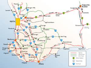
Albany Highway is a generally northwest-southeast highway in the south of Western Australia
which links the state's capital Perth
with its oldest settlement, Albany
. The highway is approximately 410 kilometres (254.8 mi) in length, is designated State Route 30 and separates Western Australia's Great Southern region from its South West region. Outside of Perth the highway is a sealed single carriageway with regular overtaking lanes in some undulating areas.
and for its first 4 km is a two-lane high street serving Victoria Park's town centre, while nearby four-lane Shepperton Road serves as the area's main conduit of traffic (it also carries the Route 30).
At Welshpool Road, the two roads merge and for 26 km Albany Highway serves as the main route for Perth's southeastern region, varying between a four- and six-lane mostly undivided carriageway. Due to the highway's evolution, this part of the highway is dominated by commercial shopping precincts in Bentley
, Cannington
, Maddington
, Gosnells
and Kelmscott
and drivers must negotiate countless sets of traffic lights. One of Perth's most infamous stretches of roads is Albany Highway in Cannington. Due to the high volume of commuters making their way to Westfield Carousel
, this section has become frequently gridlocked since its redevelopment in the late nineties. It is recommended that this section be bypassed via the Kenwick Link, the Tonkin & Leach Highways, and Welshpool Road (East), Orrong Road, and Manning Road. In the Perth section of the highway, Tonkin Highway
to the east carries most of the north-south heavy vehicle traffic, and Albany Highway is used mostly by light vehicles.
). As one keeps heading south-south-east, signs of human activity becomes more sparse as the highway crosses the Darling Scarp, and the scenery transitions to native forest. Further south it transitions again to pastureland, with farming activities being mostly livestock rearing and some orchards. Albany Highway serves as something of an express route, with the service towns in the region being located approximately 30 km to the east along Great Southern Highway
- in particular Narrogin
, Wagin
and Katanning
.
Closer to Albany, there are large tracts of blue gum
eucalypt plantations. In terms of safety, the road is generally free of hazards caused by straying farm animals, though as with most rural and remote Australian roads, kangaroos are an everpresent danger.
The only major towns on the road between Perth and Albany are Williams
, Kojonup
and Mount Barker
, with roadhouses at North Bannister
, Crossman
and Arthur River
.
As Albany Highway is not limited access, a large number of the roads that Albany Highway are connected to are not controlled. The major interchanges are at-grade and controlled.
 :
:
Albany Highway then doglegs east, and continues to leave the Perth metropolitan area.
Western Australia
Western Australia is a state of Australia, occupying the entire western third of the Australian continent. It is bounded by the Indian Ocean to the north and west, the Great Australian Bight and Indian Ocean to the south, the Northern Territory to the north-east and South Australia to the south-east...
which links the state's capital Perth
Perth, Western Australia
Perth is the capital and largest city of the Australian state of Western Australia and the fourth most populous city in Australia. The Perth metropolitan area has an estimated population of almost 1,700,000....
with its oldest settlement, Albany
Albany, Western Australia
Albany is a port city in the Great Southern region of Western Australia, some 418 km SE of Perth, the state capital. As of 2009, Albany's population was estimated at 33,600, making it the 6th-largest city in the state....
. The highway is approximately 410 kilometres (254.8 mi) in length, is designated State Route 30 and separates Western Australia's Great Southern region from its South West region. Outside of Perth the highway is a sealed single carriageway with regular overtaking lanes in some undulating areas.
History
It was originally called Albany Road and was first proposed in 1853 by Lt William Crossman of the Royal Engineers, who examined and reported on various possible Perth-Albany routes. The road was originally built of wood block and limestone by convicts in the 1850s, and was later sealed.Metropolitan road
Departing Perth, the highway commences at the Causeway interchange in Victoria ParkVictoria Park, Western Australia
The Town of Victoria Park is a Local Government Area of Western Australia. It covers an area of 17.62 km² in metropolitan Perth, the capital of Western Australia. The Town of Victoria Park maintains 154.55 km of roads, a little over 1 km² of parks and gardens and has a...
and for its first 4 km is a two-lane high street serving Victoria Park's town centre, while nearby four-lane Shepperton Road serves as the area's main conduit of traffic (it also carries the Route 30).
At Welshpool Road, the two roads merge and for 26 km Albany Highway serves as the main route for Perth's southeastern region, varying between a four- and six-lane mostly undivided carriageway. Due to the highway's evolution, this part of the highway is dominated by commercial shopping precincts in Bentley
Bentley, Western Australia
Bentley is a southern suburb of Perth, the capital city of Western Australia, and is located 8 km southeast of Perth's central business district. Its Local Government Areas are the City of Canning and the Town of Victoria Park...
, Cannington
Cannington, Western Australia
Cannington is a southern suburb of Perth, Western Australia. Its Local Government Area is the City of Canning.-History:Cannington's name derives from the Canning River, which forms part of the southwestern boundary of the suburb...
, Maddington
Maddington, Western Australia
Maddington is a suburb 20 kilometres southeast of the central business district of Perth, the capital of Western Australia, within the City of Gosnells local government area...
, Gosnells
Gosnells, Western Australia
The City of Gosnells is a Local Government Area in the southeastern suburbs of the Western Australian capital city of Perth, located northwest of Armadale and about southeast of Perth's central business district...
and Kelmscott
Kelmscott, Western Australia
Kelmscott is a southeastern suburb of Perth, Western Australia. Its Local Government Area is the City of Armadale, and it is located southeast of Perth along Albany Highway....
and drivers must negotiate countless sets of traffic lights. One of Perth's most infamous stretches of roads is Albany Highway in Cannington. Due to the high volume of commuters making their way to Westfield Carousel
Westfield Carousel
Westfield Carousel is a major shopping centre, owned by the Westfield Group and located in Cannington, a suburb of Perth. It is located approximately 12 kilometres from Perth on the Albany Highway, and approximately 600 metres from Cannington Train Station...
, this section has become frequently gridlocked since its redevelopment in the late nineties. It is recommended that this section be bypassed via the Kenwick Link, the Tonkin & Leach Highways, and Welshpool Road (East), Orrong Road, and Manning Road. In the Perth section of the highway, Tonkin Highway
Tonkin Highway
Tonkin Highway, at , is a limited access dual carriageway in Perth, Western Australia, connecting Reid Highway in the north with Thomas Road in the south. Mostly a 4 lane highway, some sections of the highway are to a 4 to 6 lane freeway standard; the remainder of the highway has been designed to...
to the east carries most of the north-south heavy vehicle traffic, and Albany Highway is used mostly by light vehicles.
Regional highway
At Armadale the highway doglegs east (the road that continues straight ahead is South Western HighwaySouth Western Highway
South Western Highway is a highway in the South West region of Western Australia connecting Perth's southeast with Walpole. It is a part of the National Highway 1 network for most of its length...
). As one keeps heading south-south-east, signs of human activity becomes more sparse as the highway crosses the Darling Scarp, and the scenery transitions to native forest. Further south it transitions again to pastureland, with farming activities being mostly livestock rearing and some orchards. Albany Highway serves as something of an express route, with the service towns in the region being located approximately 30 km to the east along Great Southern Highway
Great Southern Highway
Great Southern Highway is a highway in the Southern Wheatbelt region of Western Australia, starting from Great Eastern Highway at The Lakes, 50 km from Perth, and ending at Albany Highway near Cranbrook. It is the primary thoroughfare for this part of Western Australia and runs parallel with the...
- in particular Narrogin
Narrogin, Western Australia
Narrogin is a large town in the Wheatbelt region of Western Australia, southeast of Perth on the Great Southern Highway between Pingelly and Wagin...
, Wagin
Wagin, Western Australia
Wagin is a town and shire in the Great Southern region of Western Australia, approximately 225 km south-east of Perth on the Great Southern Highway between Narrogin and Katanning. It is also on State Route 107. The main industries are wheat and sheep farming.-History:The name of the town is...
and Katanning
Katanning, Western Australia
Katanning is a town located 277 km south east of Perth, Western Australia on the Great Southern Highway. At the 2006 census, Katanning had a population of 3,808.-History:...
.
Closer to Albany, there are large tracts of blue gum
Blue Gum
Blue Gum usually refers to the subspecies or the species in Eucalyptus globulus complex, however it may also refer to a number of other species of Eucalyptus in Australia. Confusingly, in Queensland it usually refers to Eucalyptus tereticornis, which is known elsewhere as Forest Red Gum.* Gippsland...
eucalypt plantations. In terms of safety, the road is generally free of hazards caused by straying farm animals, though as with most rural and remote Australian roads, kangaroos are an everpresent danger.
The only major towns on the road between Perth and Albany are Williams
Williams, Western Australia
Williams is a town located in the Wheatbelt region of Western Australia, south-southeast of the state capital, Perth along Albany Highway and 32 kilometres west of Narrogin. The Williams River passes through the town. At the 2006 census, Williams had a population of 338.-History:Williams is...
, Kojonup
Kojonup, Western Australia
Kojonup is a town located 256 km south-east of Perth, Western Australia along Albany Highway.The name Kojonup is believed to refer to the "Kodja" or stone axe made by Indigenous Australians from the local stone....
and Mount Barker
Mount Barker, Western Australia
Mount Barker is a town on the Albany Highway and is the administrative centre of the Shire of Plantagenet in the Great Southern region of Western Australia...
, with roadhouses at North Bannister
North Bannister, Western Australia
North Bannister is a small town located in the Wheatbelt region of Western Australia, south-southeast of the state capital, Perth along Albany Highway between Armadale and Williams....
, Crossman
Crossman, Western Australia
Crossman is a town located in the Wheatbelt region of Western Australia, south-southeast of the state capital, Perth along Albany Highway, and east of Boddington.-Origin of the name:...
and Arthur River
Arthur River, Western Australia
Arthur River is a small town located in the Wheatbelt region of Western Australia, between Williams and Kojonup on Albany Highway.-History:Arthur River is named after the river that flows through it, a headwater of the Blackwood River...
.
Swan River to Welshpool Road
For its first 4 km, Albany Highway is a two-lane high street serving Victoria Park's town centre, while nearby four-lane Shepperton Road serves as the area's main conduit of traffic (it also carries the Route 30).As Albany Highway is not limited access, a large number of the roads that Albany Highway are connected to are not controlled. The major interchanges are at-grade and controlled.
- Causeway Interchange, Victoria ParkVictoria Park, Western AustraliaThe Town of Victoria Park is a Local Government Area of Western Australia. It covers an area of 17.62 km² in metropolitan Perth, the capital of Western Australia. The Town of Victoria Park maintains 154.55 km of roads, a little over 1 km² of parks and gardens and has a...
and BurswoodBurswood, Western AustraliaBurswood is an inner southeastern suburb of Perth, Western Australia, located immediately across the Swan River from Perth's central business district via both The Causeway and Graham Farmer Freeway...
 The CausewayThe CausewayThe Causeway is the name of the traffic crossing of the Swan River in Western Australia at the eastern end of Perth Water. Made up of two bridges on either side of Heirisson Island, the crossing links the City of Perth and Victoria Park....
to Perth CBD;
 Canning HighwayCanning HighwayCanning Highway is a mostly 4 lane single carriageway major arterial road in Perth, Western Australia. The speed limit is 60 km/h. It is located south of the Swan River and links Perth with Fremantle, running between The Causeway in Victoria Park and Queen Victoria Street in...
to South PerthSouth Perth, Western AustraliaSouth Perth is a residential suburb 3 kilometres south of the central business district of Perth, the capital of Western Australia, which adjoins the southern shore of Perth Water on the Swan River...
, ApplecrossApplecross, Western AustraliaApplecross is an affluent riverside suburb of Perth, Western Australia, bounded by Canning Highway and the Swan River. It is located within the City of Melville.Like the name Perth, the suburb of Applecross borrows its name from the region in Scotland...
and FremantleFremantle, Western AustraliaFremantle is a city in Western Australia, located at the mouth of the Swan River. Fremantle Harbour serves as the port of Perth, the state capital. Fremantle was the first area settled by the Swan River colonists in 1829...
; Great Eastern HighwayGreat Eastern HighwayThe Great Eastern Highway is a major road between the Western Australian cities of Perth and Kalgoorlie. It is a key route for vehicles accessing the eastern wheatbelt and the eastern goldfields...
to Belmont, Western AustraliaBelmont, Western AustraliaThe City of Belmont is a Local Government Area in the inner eastern suburbs of the Western Australian capital city of Perth, located about east of Perth's central business district on the south bank of the Swan River...
, Perth AirportPerth AirportPerth Airport is an Australian domestic and international airport serving Perth, the capital and largest city of Western Australia. The airport itself is located in the suburb of Perth Airport....
and MidlandMidland, Western AustraliaMidland is a suburb in the Perth, Western Australia metropolitan area, as well as the regional centre for the City of Swan local government area that covers the Swan Valley and parts of the Darling Scarp to the east. It is situated at the intersection of Great Eastern Highway and Great Northern...
; and KalgoorlieKalgoorlie, Western AustraliaKalgoorlie, known as Kalgoorlie-Boulder, is a town in the Goldfields-Esperance region of Western Australia, and is located east-northeast of state capital Perth at the end of the Great Eastern Highway...- Shepperton Road to East Victoria ParkEast Victoria Park, Western AustraliaEast Victoria Park is a suburb of Perth, Western Australia, located within the Town of Victoria Park....
.
- Duncan Street/McMillan Street, Victoria ParkVictoria Park, Western AustraliaThe Town of Victoria Park is a Local Government Area of Western Australia. It covers an area of 17.62 km² in metropolitan Perth, the capital of Western Australia. The Town of Victoria Park maintains 154.55 km of roads, a little over 1 km² of parks and gardens and has a...
- Mint Street, East Victoria ParkEast Victoria Park, Western AustraliaEast Victoria Park is a suburb of Perth, Western Australia, located within the Town of Victoria Park....
- Oats Street/Hill View Terrace, East Victoria ParkEast Victoria Park, Western AustraliaEast Victoria Park is a suburb of Perth, Western Australia, located within the Town of Victoria Park....
- Interchange, St JamesSt James, Western AustraliaSt James is a suburb of the City of Canning, partially contained within the Town of Victoria Park.-References:...
and East Victoria ParkEast Victoria Park, Western AustraliaEast Victoria Park is a suburb of Perth, Western Australia, located within the Town of Victoria Park....
- Shepperton Road to Perth;
- (Former
 ) Welshpool RoadWelshpool Road, PerthWelshpool Road is a major arterial road running through the metropolitan area of Perth, Western Australia. Although the road is now split in two, having had its West and East sections disconnected due to the extension of Roe Highway, it remains Welshpool's second most important road , and the...
to WelshpoolWelshpool, Western AustraliaWelshpool is an inner southeastern suburb of Perth, located mostly within the City of Canning. The area is considered to be one of the main industrial areas of Perth, along with Kewdale, Kwinana, Henderson, Malaga, O'Connor, Canning Vale and Osborne Park....
(previously the main southern route to KalamundaKalamunda, Western Australia-Transport:Kalamunda Road serves as a major access road for Perth Airport, and provides the foothills suburbs with access to the Perth central business district....
)
Welshpool Road to Armadale Road
Signed as:
- John Street/Ashburton Street, BentleyBentley, Western AustraliaBentley is a southern suburb of Perth, the capital city of Western Australia, and is located 8 km southeast of Perth's central business district. Its Local Government Areas are the City of Canning and the Town of Victoria Park...
 Leach HighwayLeach HighwayLeach Highway is a major dual carriageway arterial road in Perth, Western Australia, which varies between 4 and 6 lanes wide. The speed limit is either 70 or 80 km/h. It is located south of the Swan River and links Fremantle with Kewdale, a distance of ....
, BentleyBentley, Western AustraliaBentley is a southern suburb of Perth, the capital city of Western Australia, and is located 8 km southeast of Perth's central business district. Its Local Government Areas are the City of Canning and the Town of Victoria Park... Manning Road, CanningtonCannington, Western AustraliaCannington is a southern suburb of Perth, Western Australia. Its Local Government Area is the City of Canning.-History:Cannington's name derives from the Canning River, which forms part of the southwestern boundary of the suburb...
to Curtin UniversityCurtin University of TechnologyCurtin University is an Australian university based in Perth, Western Australia, with additional campuses in regional Western Australia and at Miri , Sydney and Singapore...- Cecil Avenue, CanningtonCannington, Western AustraliaCannington is a southern suburb of Perth, Western Australia. Its Local Government Area is the City of Canning.-History:Cannington's name derives from the Canning River, which forms part of the southwestern boundary of the suburb...
(at Westfield CarouselWestfield CarouselWestfield Carousel is a major shopping centre, owned by the Westfield Group and located in Cannington, a suburb of Perth. It is located approximately 12 kilometres from Perth on the Albany Highway, and approximately 600 metres from Cannington Train Station...  Nicholson Road to ThornlieThornlie, Western AustraliaThornlie is a large outer suburb of Perth, Western Australia, located 18 kilometres south-east of Perth's central business district. It is part of the City of Gosnells local government area. The Canning River runs through the northern side of the suburb...
and Canning ValeCanning Vale, Western AustraliaCanning Vale is a large southern suburb of Perth, and is located 20 km from the Perth CBD. Its Local Government Areas are the City of Canning and the City of Gosnells .-History:...- → William Street/Kenwick Link, BeckenhamBeckenham, Western AustraliaBeckenham is a suburb of Perth, Western Australia, located within the City of Gosnells.-History:This suburb has seen many name changes. It was most recently known as Buckingham, it once shared a "common usage" name of Waverley with East Cannington, and has one of the oldest primary schools in...
- Wanaping Road/Royal Street, KenwickKenwick, Western AustraliaKenwick, Western Australia is a mixed residential, light industrial and semi-rural suburb located in the south-east of Perth, Western Australia, located within the City of Gosnells...
- → Austin Avenue/Kenwick Link, KenwickKenwick, Western AustraliaKenwick, Western Australia is a mixed residential, light industrial and semi-rural suburb located in the south-east of Perth, Western Australia, located within the City of Gosnells...
and MaddingtonMaddington, Western AustraliaMaddington is a suburb 20 kilometres southeast of the central business district of Perth, the capital of Western Australia, within the City of Gosnells local government area... - Kelvin Road/Olga Road, MaddingtonMaddington, Western AustraliaMaddington is a suburb 20 kilometres southeast of the central business district of Perth, the capital of Western Australia, within the City of Gosnells local government area...
(to Centro Maddington, HuntingdaleHuntingdale, Western AustraliaHuntingdale, Western Australia is a southeastern suburb of Perth, Western Australia. It is part of the City of Gosnells local government area. It is largely a residential suburb with associated schools and small businesses, mainly existing to service local residents...
and Canning ValeCanning Vale, Western AustraliaCanning Vale is a large southern suburb of Perth, and is located 20 km from the Perth CBD. Its Local Government Areas are the City of Canning and the City of Gosnells .-History:...  Fremantle Road, GosnellsGosnells, Western AustraliaThe City of Gosnells is a Local Government Area in the southeastern suburbs of the Western Australian capital city of Perth, located northwest of Armadale and about southeast of Perth's central business district...
(at Gosnells Railway Markets, to GosnellsGosnells, Western AustraliaThe City of Gosnells is a Local Government Area in the southeastern suburbs of the Western Australian capital city of Perth, located northwest of Armadale and about southeast of Perth's central business district...- Ferres Drive, GosnellsGosnells, Western AustraliaThe City of Gosnells is a Local Government Area in the southeastern suburbs of the Western Australian capital city of Perth, located northwest of Armadale and about southeast of Perth's central business district...
(was terminus of Tonkin Highway until 2005)  Tonkin HighwayTonkin HighwayTonkin Highway, at , is a limited access dual carriageway in Perth, Western Australia, connecting Reid Highway in the north with Thomas Road in the south. Mostly a 4 lane highway, some sections of the highway are to a 4 to 6 lane freeway standard; the remainder of the highway has been designed to...
, GosnellsGosnells, Western AustraliaThe City of Gosnells is a Local Government Area in the southeastern suburbs of the Western Australian capital city of Perth, located northwest of Armadale and about southeast of Perth's central business district...- Denny Avenue/Gilwell Street, KelmscottKelmscott, Western AustraliaKelmscott is a southeastern suburb of Perth, Western Australia. Its Local Government Area is the City of Armadale, and it is located southeast of Perth along Albany Highway....
(at Kelmscott Village)  Brookton HighwayBrookton HighwayBrookton Highway is a 504 kilometre long undivided single carriageway highway in Western Australia, running from the southern Perth suburb of Kelmscott, through Westdale, to the southern Wheatbelt town of Brookton...
, KelmscottKelmscott, Western AustraliaKelmscott is a southeastern suburb of Perth, Western Australia. Its Local Government Area is the City of Armadale, and it is located southeast of Perth along Albany Highway....
and Mount NasuraMount Nasura, Western AustraliaMount Nasura is a suburb of Perth, Western Australia, located within the City of Armadale. During the 1980s and 1990s, residents successfully campaigned to have the name of the area changed from Armadale to Mount Nasura. Within the suburb is the Armadale-Kelmscott District Memorial Hospital....
- Interchange, ArmadaleArmadale, Western AustraliaArmadale is a suburb within the City of Armadale, located on the south-eastern edge of Perth's metropolitan area. The major junction of the South Western and Albany Highways, which connect Perth with the South West and Great Southern regions of Western Australia respectively, is located within the...
and BedfordaleBedfordale, Western AustraliaBedfordale is a semi-rural suburb in the south east of Perth, Western Australia, located within the City of Armadale. Located approximately 40km from Perth in the Darling Range, some of the local attractions include Churchman Brook Dam, Wungong Dam and the Elizabethan Pub. . The area is popular for...
-
 South Western HighwaySouth Western HighwaySouth Western Highway is a highway in the South West region of Western Australia connecting Perth's southeast with Walpole. It is a part of the National Highway 1 network for most of its length...
to SerpentineSerpentine, Western AustraliaSerpentine is a town located south-southeast of Perth, the capital of Western Australia, and 7 km south of Mundijong. Serpentine is located on the South Western Railway between Perth and Bunbury, and was one of the original stations when the line was opened in 1893...
, PinjarraPinjarra, Western AustraliaPinjarra is a town in the Peel region of Western Australia along the South Western Highway, from the state capital, Perth and south-east of the coastal city of Mandurah. Its local government area is the Shire of Murray. At the 2006 census, Pinjarra had a population of 3,279.Pinjarra is an area...
and BunburyBunbury, Western AustraliaThe port city of Bunbury is the third largest city in Western Australia after the State Capital Perth and Mandurah. It is situated south of Perth's central business district... -
 Armadale Road to Jandakot and SpearwoodSpearwood, Western AustraliaSpearwood is a southern suburb of Perth, Western Australia, located within the City of Cockburn. It was named by colonial settlers who noticed the native tea trees, scientific name Melaleuca lanceolata Chipolata, being used for spears by the Yugul Aboriginal people.-History:Settlement appears to...
 - Albany Highway.
-
Beyond Perth metropolitan area
Albany Highway then doglegs east, and continues to leave the Perth metropolitan area.-
 to JarrahdaleJarrahdale, Western AustraliaJarrahdale is a small historic town located 50 km south-east of Perth, Western Australia in the Darling Range. Jarrahdale is a descriptive name, derived from its situation in some of Western Australia's best Jarrah forest...
 - (at North Bannister) to WanderingWandering, Western AustraliaWandering is a town located in the Wheatbelt region of Western Australia, approximately from the state capital, Perth, just off the Albany Highway. It is the main town in the Shire of Wandering...
- (at Bannister) to BoddingtonBoddington, Western AustraliaBoddington is a town and shire in the Peel region of Western Australia, located south-east of Perth. The town sits on the road from Pinjarra to Williams on the Hotham River...
- (at Crossman) to BoddingtonBoddington, Western AustraliaBoddington is a town and shire in the Peel region of Western Australia, located south-east of Perth. The town sits on the road from Pinjarra to Williams on the Hotham River...
, WanderingWandering, Western AustraliaWandering is a town located in the Wheatbelt region of Western Australia, approximately from the state capital, Perth, just off the Albany Highway. It is the main town in the Shire of Wandering...
and PingellyPingelly, Western AustraliaPingelly is a town and shire located in the Wheatbelt region of Western Australia, from Perth via the Brookton Highway and Great Southern Highway. The town is also located on the Great Southern railway line... - (at Williams) → to BoddingtonBoddington, Western AustraliaBoddington is a town and shire in the Peel region of Western Australia, located south-east of Perth. The town sits on the road from Pinjarra to Williams on the Hotham River...
, DwellingupDwellingup, Western AustraliaDwellingup is a town in Western Australia, located in a timber and fruitgrowing area in the Darling Range east-south-east of Pinjarra. At the 2006 census, Dwellingup had a population of 346.-Name:...
, CollieCollie, Western Australia-External links:*...
and DarkanDarkan, Western AustraliaDarkan is a town located in the Wheatbelt region of Western Australia, between Collie and the Albany Highway on the Coalfields Road. It is also the seat of the Shire of West Arthur. At the 2006 census, Darkan had a population of 203.-History:... - (at Williams) ← to NarroginNarrogin, Western AustraliaNarrogin is a large town in the Wheatbelt region of Western Australia, southeast of Perth on the Great Southern Highway between Pingelly and Wagin...
, WickepinWickepin, Western AustraliaWickepin is a town in the Wheatbelt region of Western Australia, south-east of Perth and east of Narrogin. At the 2006 census, Wickepin had a population of 244.-History:...
and KulinKulin, Western AustraliaKulin is a town located in the Eastern Wheatbelt region of Western Australia, approximately 280 km from Perth. It is the main town in the Shire of Kulin.- History :... -
 (at Arthur River) → Coalfields RoadCoalfields RoadCoalfields Highway, formerly known as Coalfields Road, is a Western Australian highway linking Roelands on the South Western Highway with Arthur River on the Albany Highway...
to DarkanDarkan, Western AustraliaDarkan is a town located in the Wheatbelt region of Western Australia, between Collie and the Albany Highway on the Coalfields Road. It is also the seat of the Shire of West Arthur. At the 2006 census, Darkan had a population of 203.-History:...
, CollieCollie, Western Australia-External links:*...
and BunburyBunbury, Western AustraliaThe port city of Bunbury is the third largest city in Western Australia after the State Capital Perth and Mandurah. It is situated south of Perth's central business district... - (at Arthur River) ← Coalfields RoadCoalfields RoadCoalfields Highway, formerly known as Coalfields Road, is a Western Australian highway linking Roelands on the South Western Highway with Arthur River on the Albany Highway...
to WaginWagin, Western AustraliaWagin is a town and shire in the Great Southern region of Western Australia, approximately 225 km south-east of Perth on the Great Southern Highway between Narrogin and Katanning. It is also on State Route 107. The main industries are wheat and sheep farming.-History:The name of the town is...
, DumbleyungDumbleyung, Western AustraliaDumbleyung is a town and shire in the Wheatbelt region of Western Australia, south-east of Perth between Wagin and Lake Grace on State Route 107.-History:...
and Lake GraceLake Grace, Western Australia-Natural disasters:In late 2005 and early 2006, Lake Grace experienced two natural disasters. The first was a hail storm on 16 October 2005, which destroyed 500 hectares of wheat and barley crop and damaged a further 5,500 hectares, with some farmers reporting fields covered by up to... - (at Kojonup) to KatanningKatanning, Western AustraliaKatanning is a town located 277 km south east of Perth, Western Australia on the Great Southern Highway. At the 2006 census, Katanning had a population of 3,808.-History:...
, BroomehillBroomehill, Western AustraliaBroomehill is a town located along the Great Southern Highway between Katanning and Albany, in the Great Southern region of Western Australia.- History :...
, GnowangerupGnowangerup, Western AustraliaGnowangerup is a town located south east of Katanning in the Great Southern region of Western Australia. The townsite was first gazetted in 1908 under the spelling of Ngowangerupp. Local dissatisfaction with this spelling led to it being altered to Gnowangerup in 1913.A branch railway from...
and Boyup BrookBoyup Brook, Western AustraliaBoyup Brook is a town located in the south-west of Western Australia, south-southeast of Perth and northeast of Bridgetown.The name Boyup is derived from the name of a nearby pool "Booyup", an Aboriginal term meaning "place of big stones" or "place of big smoke" .The town's economy is... -
 (near Cranbrook) Great Southern HighwayGreat Southern HighwayGreat Southern Highway is a highway in the Southern Wheatbelt region of Western Australia, starting from Great Eastern Highway at The Lakes, 50 km from Perth, and ending at Albany Highway near Cranbrook. It is the primary thoroughfare for this part of Western Australia and runs parallel with the...
to CranbrookCranbrook, Western AustraliaCranbrook is a small town in the Great Southern region of Western Australia between Katanning, Kojonup and Mount Barker, situated 320km south of Perth. It is billed as "The Gateway to the Stirlings", referring to the nearby Stirling Range National Park...
, TambellupTambellup, Western AustraliaThe townsite of Tambellup is located in Western Australia's Great Southern Agricultural region, 317 km south-east of Perth on the Great Southern Highway where it crosses the Gordon River...
, KatanningKatanning, Western AustraliaKatanning is a town located 277 km south east of Perth, Western Australia on the Great Southern Highway. At the 2006 census, Katanning had a population of 3,808.-History:...
and WaginWagin, Western AustraliaWagin is a town and shire in the Great Southern region of Western Australia, approximately 225 km south-east of Perth on the Great Southern Highway between Narrogin and Katanning. It is also on State Route 107. The main industries are wheat and sheep farming.-History:The name of the town is... -
 (at Mount Barker) Muirs HighwayMuirs HighwayMuirs Highway is a Western Australian highway linking Manjimup and Mount Barker on the Albany Highway. It is signed as State Route 102 and is long. It provides a shorter distance between Manjimup and Albany...
to DenmarkDenmark, Western AustraliaDenmark is a town in the Great Southern region of Western Australia, south-south-east of the state capital of Perth. At the 2006 census, Denmark had a population of 2,732.-History:...
and ManjimupManjimup, Western AustraliaManjimup is a town in Western Australia, south of the state capital, Perth. The town of Manjimup is a regional centre for the largest shire in the South West of Western Australia. At the 2006 census, Manjimup had a population of 4,239.-History:... - (at Mount Barker) to Stirling Range National ParkStirling Range National ParkStirling Range National Park is a national park in the Great Southern region of Western Australia, approximately 337 km south-east of Perth.-Description:...
and Porongurup National ParkPorongurup National ParkPorongurup National Park is a national park in the Great Southern region of Western Australia , 360 km southeast of Perth and 40 km from Albany....
Albany
- Interchange, OranaOrana, Western AustraliaOrana is a north-western suburb of Albany in southern Western Australia, located north west of Albany's central business district. Its Local Government Area is the City of Albany...
- South Coast HighwaySouth Coast HighwaySouth Coast Highway is a Western Australia highway. It is a part of the Highway 1 network.With a length of , it runs from Esperance to Walpole roughly in parallel to the Western Australia's south coast...
to EllekerElleker, Western AustraliaElleker is a small town in the Great Southern region of Western Australia, situated about west of the regional city of Albany.The town was planned by the Western Australian Land Company, who built the Great Southern Railway in 1886-1889. It was originally known as Lakeside, due to its proximity to...
, DenmarkDenmark, Western AustraliaDenmark is a town in the Great Southern region of Western Australia, south-south-east of the state capital of Perth. At the 2006 census, Denmark had a population of 2,732.-History:...
, WalpoleWalpole, Western AustraliaWalpole is a town in Western Australia, 432 km SSE of Perth and 66 km west of Denmark.Walpole lies very close to the northern point of the 100-hectare Walpole Inlet, from which it takes its name.... - South Coast HighwaySouth Coast HighwaySouth Coast Highway is a Western Australia highway. It is a part of the Highway 1 network.With a length of , it runs from Esperance to Walpole roughly in parallel to the Western Australia's south coast...
(Chester Pass Road) to RavensthorpeRavensthorpe, Western AustraliaRavensthorpe is a town 541 km south east of Perth, 40 km inland from the south coast of Western Australia. It is the seat of government of the Shire of Ravensthorpe... - North Road to Middleton BeachMiddleton Beach, Western AustraliaMiddleton Beach is a coastal suburb of Albany, Western Australia, located within the City of Albany approximately east of the city centre. It is home to a caravan park and numerous holiday units which provide accommodation for visitors to the Albany region....
and Emu PointEmu Point, Western AustraliaEmu Point is a north-eastern suburb of Albany in southern Western Australia, located north east of Albany's central business district. Its Local Government Area is the City of Albany... - Hanrahan Road to Frenchman Bay
-
- Interchange, AlbanyAlbany, Western AustraliaAlbany is a port city in the Great Southern region of Western Australia, some 418 km SE of Perth, the state capital. As of 2009, Albany's population was estimated at 33,600, making it the 6th-largest city in the state....
- York Street (Albany CBD and Port)
- Lockyer Avenue to Centennial ParkCentennial Park, Western AustraliaCentennial Park is an inner suburb of Albany, Western Australia, immediately north of the CBD. Its Local Government Area is the City of Albany...
and Spencer ParkSpencer Park, Western AustraliaSpencer Park is a north-eastern suburb of Albany in southern Western Australia, located north-northeast of Albany's central business district. Its Local Government Area is the City of Albany, and the suburb was first gazetted in 1954.-Geography:... - Middleton Road to Middleton BeachMiddleton Beach, Western AustraliaMiddleton Beach is a coastal suburb of Albany, Western Australia, located within the City of Albany approximately east of the city centre. It is home to a caravan park and numerous holiday units which provide accommodation for visitors to the Albany region....