

Gary Highway
Encyclopedia
Western Australia
Western Australia is a state of Australia, occupying the entire western third of the Australian continent. It is bounded by the Indian Ocean to the north and west, the Great Australian Bight and Indian Ocean to the south, the Northern Territory to the north-east and South Australia to the south-east...
built by Len Beadell
Len Beadell
Leonard Beadell OAM BEM FIEMS was a surveyor, roadbuilder , bushman, artist and author, responsible for opening up the last remaining isolated desert areas of central Australia from 1947 to 1963. Len is sometimes called "the last true Australian explorer"...
's Gunbarrel Road Construction Party in April and May 1963 and named after Beadell's son who was born earlier that year.
It connects the Gunbarrel Highway
Gunbarrel Highway
The Gunbarrel Highway is an isolated desert track in the Northern Territory, South Australia and Western Australia. It consists of about of washaways, heavy corrugations, stone, sand and flood plains...
at Everard Junction in the Gibson Desert
Gibson Desert
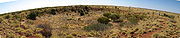
The Gibson Desert covers a large dry area in the state of Western Australia and is still largely in an almost "pristine" state. It is about in size, making it the 5th largest desert in Australia, after the Great Sandy, Great Victoria, Tanami and Simpson deserts.-Location and description:The Gibson...
to the south, to the Gary Junction Road at Gary Junction on the edge of the Great Sandy Desert
Great Sandy Desert
The Great Sandy Desert is a desert located in the North West of Western Australia straddling the Pilbara and southern Kimberley regions. It is the second largest desert in Australia after the Great Victoria Desert and encompasses an area of...
to the north. It is one of only two north-south tracks in the central deserts of Western Australia, the other being the Sandy Blight Junction Road, another Len Beadell track.
The Gary Highway passes several interesting points in its 400 kilometres (248.5 mi) desert crossing:
- Veevers craterVeevers craterVeevers crater is an impact crater located on a flat desert plain between the Great Sandy and Gibson Deserts in the center of the state of Western Australia, Australia. The site is very remote and difficult to visit...
16 kilometres (9.9 mi) off the track (GPS Ref: -22.969880, 125.372293, turn off at -23.0822, 125.2808). The visitors' book contains entries from the original team who identified the crater. This meteorite explosion crater is one of only 15 known worldwide, and only 3 in Western Australia. A good description can be found in the Australian Government Heritage site.
- Tropic of CapricornTropic of CapricornThe Tropic of Capricorn, or Southern tropic, marks the most southerly latitude on the Earth at which the Sun can be directly overhead. This event occurs at the December solstice, when the southern hemisphere is tilted towards the Sun to its maximum extent.Tropic of Capricorn is one of the five...
with several marker signs in different places, due to the shift of the tropics over time caused by the varying tilt of the Earth's orbit.
- Windy Corner (the junction at the end of the Talawana Track. GPS Ref: -23.572440, 125.194373). The origins of the name "Windy Corner" can be read in Beadell's 1983 book End Of An Era.
- McDougall Knoll, which is a good lookout point (GPS Ref: --23.944397, 125.244998). There are notes from visitors contained in a tin can jammed in the cairn.
- The junction of the Eagle Highway, which appears very overgrown (GPS Ref: -24.345560, 125.106053).
- The Gibson Desert Nature Reserve which includes McPhersons Pillar (GPS Ref: -24.569760, 125.324522, turn off at -24.5482, 125.032020). This is 30 km off the track but is a spectacular landmark with excellent views over the Gibson Desert and access to Mulgan Rockhole (GPS Ref: -24.57212, 125.2987).
- Charlies Knob (GPS Ref: -25.051343, 124.975467).
- Everard Junction on the Gunbarrel Highway (GPS Ref: -25.173720, 124.979333), where there is another interesting visitors book.
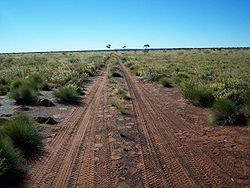
The track itself is a single lane, not overgrown but quite corrugated over its entire length and for the most part quite straight, with the exception of a section from 22.85ºS to 22.88ºS where the track winds between sand dunes.
The track was quite navigable (in September 2007), there are no sand dunes to climb and the surface is hard sand and gravel although the southern end has suffered several wash-aways through the Gibson Desert Nature Reserve.
The total length of the track is about 425 kilometres (264.1 mi), including side trips to Veevers Crater and McPhersons Pillar. It is a very remote track with both the start and end being many hundreds of kilometres from any significant settlements or major supply points. An HF radio or satellite phone
Satellite phone
A satellite telephone, satellite phone, or satphone is a type of mobile phone that connects to orbiting satellites instead of terrestrial cell sites...
should be carried as there are no buildings, habitation or facilities of any kind along this track and travellers should be totally self-sufficient in terms of fuel, food, water and vehicle support. The nearest supplies are to the north at Kunawaritji
Kunawaritji
Kunawaritji Community is a location on the Canning Stock Route near Well 33, and also the eastern end of Wapet Road in the Pilbara region of Western Australia.The name has variant spellings - it is also can be found as Kunnawarritji....
near Well 33 on the Canning Stock Route
Canning Stock Route
The Canning Stock Route is one of the toughest and most remote tracks in the world. It runs to Halls Creek from Wiluna, both in Western Australia. With a total distance of around it is also the longest historic stock route in the world...
, or some 300 kilometres (186.4 mi) south of Everard Junction at Warburton Roadhouse
Warburton, Western Australia
Warburton or Warburton Ranges is an Indigenous Australian community in Western Australia, just to the south of the Gibson Desert and located on the Great Central Road and Gunbarrel Highway...
to the east, or Carnegie Station to the west.