
Bylong Valley Way
Encyclopedia
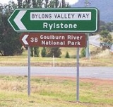
Bylong Valley Way is a New South Wales
country road linking the Golden Highway
near Sandy Hollow
to the Castlereagh Highway
near Ilford
. It is named after the Bylong Valley
, through which the road passes.
to Bathurst
, this quiet, scenic route provides a leisurely alternative to going through Sydney
to travel between the Hunter Valley
and Central Tablelands
.
The part of the Bylong Valley Way east of Bylong
is designated MR 208. At a T-intersection near the railway level crossing just north of the village of Bylong, MR 208 turns off towards Ulan
, following the Ulan railway line to the west while the Bylong Valley Way becomes MR 215 as it turns south to pass through Bylong, Rylstone
and Kandos
.
 Access to the Wollemi National Park
and Goulburn River National Park
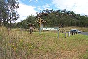
is available at various points along the road between the Golden Highway and Bylong. Over Coxs Gap, the Bylong Valley Way is flanked by the two national parks. Camping areas are available in the Wollemi National Park on the western side of Coxs Gap, and the Phipps Cutting picnic area between Baerami and Widden Creek provides an entry point for hiking in the Wollemi National Park.
created a web site for the road, to promote it as a tourist route.
The section of the Bylong Valley Way east of Bylong is also part of two separately promoted tourist routes.
A self-drive tour loop route originating in Sandy Hollow, promoted as Upper Hunter Tourist Drive number 4, uses this section of road to travel west, then turns north on other local roads to rejoin the Golden Highway. The Phipps Cutting picnic area is shown as a rest area on that route.
The Tablelands Way tourist route between Canberra
and Muswellbrook
uses this section of the Bylong Valley Way as part of the route between Mudgee and Muswellbrook.
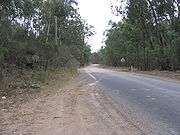 The Bylong Valley Way was not fully sealed in the Mid-Western Regional Council
area until February 2009. Sealing of the road had been a political issue for decades. At the beginning of 2007, there were four sections of unsealed road totalling 32 kilometres. Two sections were between Coxs Gap and Bylong with only 850 metres of sealed road between them. The other two were south of Bylong on the way towards Rylstone, where two kilometres had been sealed a few years earlier, converting one long unsealed section to two shorter ones.
On 13 December 2006, The federal government announced A$
2 million of Auslink
funding towards the $4.1 million cost of completion of sealing of the Bylong Valley Way. Under the announced funding arrangement, the New South Wales Roads and Traffic Authority
contributed $900,000 and the Mid-Western Regional Council was to contribute the remaining $1.2 million. The overall cost slightly exceed the budgeted $4.1 million, with the council having to cover the over-run.
The sealing work was carried out by Mid-Western Regional Council and was completed in three stages:
were demolished and were planned to be replaced with new concrete sections by 31 August 2007. Unfortunately, flooding during the 2007 Hunter region and Central Coast storms delayed the work by around a month. The bridge had previously been partially rebuilt, with both buttresses and two spans at one end having been reconstructed in concrete.
Muswellbrook Shire Council maintained a temporary deviation on private property for several years to allow access during bridgework and for heavy vehicles. After the bridge was reopened, that deviation was removed and the land returned to its owner.
The single-lane timber bridge over Widden Creek is also to be replaced. Muswellbrook Shire Council had committed to spend $480,000 by 30 June 2007 to Manage the investigation, design and construction works but the discovery of a serious problem on Kirks Bridge saw that money diverted to the more urgent project. Muswellbrook Shire Council now plan to replace the Widden Creek bridge by 30 June 2009 at a cost of A$1.4 Million.
Once the Widden Creek bridge is replaced, the 38 tonne load limit will be lifted, allowing heavy vehicles to again use this route.
and Ilford between mid 2009 and mid 2010.
 The Sandy Hollow- Gulgong railway line
and part of the Merriwa railway line
, which form the Australian Rail Track Corporation
's Ulan line between Muswellbrook and Gulgong
, follow the same valleys as the Bylong Valley Way from near the Golden Highway to near Bylong, where the railway line continues west as the road turns south.
The Ulan line crosses the road three times, twice at level crossings and once on a bridge over the road. One level crossing is close to the Golden Highway while the other is close to Bylong. The railway bridge is on the western side of Coxs Gap, between the level crossings.
The Gwabegar railway line
crosses the road on at a level crossing the northern side of Rylstone.
All three of the level crossings have flashing warning lights but not boom gates.
New South Wales
New South Wales is a state of :Australia, located in the east of the country. It is bordered by Queensland, Victoria and South Australia to the north, south and west respectively. To the east, the state is bordered by the Tasman Sea, which forms part of the Pacific Ocean. New South Wales...
country road linking the Golden Highway
Golden Highway
The Golden Highway is a highway in New South Wales, Australia.Designated as State Highway 84, it runs eastwards from Dubbo towards Newcastle on the coast and enables road transport to avoid travelling over the Blue Mountains to Sydney....
near Sandy Hollow
Sandy Hollow, New South Wales
Sandy Hollow is a small rural town in New South Wales, Australia in Muswellbrook Shire. The town is located on the Golden Highway in the far west of the Upper Hunter Valley region, about 260 km north of Sydney....
to the Castlereagh Highway
Castlereagh Highway
The Castlereagh Highway is a state highway in New South Wales, Australia, also extending some kilometres into Queensland. It has been given the route number 55. The highway was recently extended past Gilgandra to include state route 86...
near Ilford
Ilford, New South Wales
Ilford is a small town in New South Wales, Australia, in the Mid-Western Regional Council. It is named after the small English town of Ilford , where the founders of this town came from. It is situated around 220 km north west of Sydney. It is located on the Castlereagh Highway, which is...
. It is named after the Bylong Valley
Bylong Valley
The Bylong Valley is a winding but relatively flat valley that crosses the Great Dividing Range between the Goulburn River National Park and Wollemi National Park, west of the upper Hunter Valley in New South Wales, Australia....
, through which the road passes.
Connections
In conjunction with the Bathurst-Ilford RoadBathurst-Ilford Road
Bathurst to Ilford Road is a 72 kilometre New South Wales country road linking the Castlereagh Highway at Ilford to the regional highway hub of Bathurst, where several roads including the Great Western Highway, Mid-Western Highway and Mitchell Highways and O'Connell Road to Oberon join...
to Bathurst
Bathurst, New South Wales
-CBD and suburbs:Bathurst's CBD is located on William, George, Howick, Russell, and Durham Streets. The CBD is approximately 25 hectares and surrounds two city blocks. Within this block layout is banking, government services, shopping centres, retail shops, a park* and monuments...
, this quiet, scenic route provides a leisurely alternative to going through Sydney
Sydney
Sydney is the most populous city in Australia and the state capital of New South Wales. Sydney is located on Australia's south-east coast of the Tasman Sea. As of June 2010, the greater metropolitan area had an approximate population of 4.6 million people...
to travel between the Hunter Valley
Hunter Valley
The Hunter Region, more commonly known as the Hunter Valley, is a region of New South Wales, Australia, extending from approximately to north of Sydney with an approximate population of 645,395 people. Most of the population of the Hunter Region lives within of the coast, with 55% of the entire...
and Central Tablelands
Central Tablelands
The Central Tablelands in New South Wales is an area that is between the Sydney Metropolitan Area and the Central West Slopes and Plains. This area has a part of the Great Dividing Range running through it, including the Blue Mountains...
.
The part of the Bylong Valley Way east of Bylong
Bylong, New South Wales
Bylong is a village in New South Wales, Australia, in the Mid-Western Regional Council. It is located on the Bylong Valley Way.The area is home to numerous horse studs...
is designated MR 208. At a T-intersection near the railway level crossing just north of the village of Bylong, MR 208 turns off towards Ulan
Ulan, New South Wales
Ulan is a small village in eastern New South Wales, Australia. Ulan Post Office opened on 1 September 1893.There is a coal mine at Ulan. The Sandy Hollow - Ulan Railway was built to serve this coal mine...
, following the Ulan railway line to the west while the Bylong Valley Way becomes MR 215 as it turns south to pass through Bylong, Rylstone
Rylstone, New South Wales
Rylstone is a small town in New South Wales, Australia, in the Central Tablelands region within the Mid-Western Regional Council local government area. It is located on the Bylong Valley Way road route...
and Kandos
Kandos, New South Wales
Kandos is a small town in New South Wales, Australia, in the Mid-Western Regional Council. It is located on the Bylong Valley Way. At the 2006 census, Kandos had a population of 1,306 people.The main non-agricultural industry is the production of cement...
.
National Park access
Wollemi National Park
Wollemi National Park is the second largest national park in New South Wales, and contains most of the largest wilderness area, the Wollemi Wilderness...
and Goulburn River National Park
Goulburn River National Park
Goulburn River National Park is in New South Wales, Australia, 280 km northwest of Sydney and it is 20 km south-west of Merriwa. The Goulburn River National Park is located in Hunter Valley and covers approximately 90 km of the Goulburn River...
is available at various points along the road between the Golden Highway and Bylong. Over Coxs Gap, the Bylong Valley Way is flanked by the two national parks. Camping areas are available in the Wollemi National Park on the western side of Coxs Gap, and the Phipps Cutting picnic area between Baerami and Widden Creek provides an entry point for hiking in the Wollemi National Park.
Tourism
Following completion of sealing of the road, The Muswellbrook Chamber of Commerce and IndustryChamber of commerce
A chamber of commerce is a form of business network, e.g., a local organization of businesses whose goal is to further the interests of businesses. Business owners in towns and cities form these local societies to advocate on behalf of the business community...
created a web site for the road, to promote it as a tourist route.
The section of the Bylong Valley Way east of Bylong is also part of two separately promoted tourist routes.
A self-drive tour loop route originating in Sandy Hollow, promoted as Upper Hunter Tourist Drive number 4, uses this section of road to travel west, then turns north on other local roads to rejoin the Golden Highway. The Phipps Cutting picnic area is shown as a rest area on that route.
The Tablelands Way tourist route between Canberra
Canberra
Canberra is the capital city of Australia. With a population of over 345,000, it is Australia's largest inland city and the eighth-largest city overall. The city is located at the northern end of the Australian Capital Territory , south-west of Sydney, and north-east of Melbourne...
and Muswellbrook
Muswellbrook, New South Wales
Muswellbrook, a corruption of 'Muscle Brook', is a town and Local Government Area in New South Wales, Australia. The original spelling and etymology of the town's name is a matter of some debate...
uses this section of the Bylong Valley Way as part of the route between Mudgee and Muswellbrook.
Sealing
Mid-Western Regional Council, New South Wales
The Mid-Western Regional Council is a Local Government Area in the Central West of New South Wales. The Castlereagh Highway passes through the middle of the area in an approximate southeast-northwest direction....
area until February 2009. Sealing of the road had been a political issue for decades. At the beginning of 2007, there were four sections of unsealed road totalling 32 kilometres. Two sections were between Coxs Gap and Bylong with only 850 metres of sealed road between them. The other two were south of Bylong on the way towards Rylstone, where two kilometres had been sealed a few years earlier, converting one long unsealed section to two shorter ones.
On 13 December 2006, The federal government announced A$
Australian dollar
The Australian dollar is the currency of the Commonwealth of Australia, including Christmas Island, Cocos Islands, and Norfolk Island, as well as the independent Pacific Island states of Kiribati, Nauru and Tuvalu...
2 million of Auslink
AusLink
AusLink was an Australian Government land transport funding program, established in June 2004 and administered by the Department of Transport and Regional Services. In 2009 it was replaced with the Nation Building Program under the Nation Building Program Act 2009...
funding towards the $4.1 million cost of completion of sealing of the Bylong Valley Way. Under the announced funding arrangement, the New South Wales Roads and Traffic Authority
Roads and Traffic Authority
The Roads and Traffic Authority is a former New South Wales government agency that was responsible for major road infrastructure, licensing of drivers, and registration of motor vehicles. The RTA directly managed State roads and provided funding to local councils for regional and local roads...
contributed $900,000 and the Mid-Western Regional Council was to contribute the remaining $1.2 million. The overall cost slightly exceed the budgeted $4.1 million, with the council having to cover the over-run.
The sealing work was carried out by Mid-Western Regional Council and was completed in three stages:
Stage One
- March 2007 to June 2007
- Sealing of two sections totalling six kilometres south of Bylong
- Widening a total of nine kilometres of remaining unsealed road in preparation for sealing in the later stages
Stage Two
- July 2007 to June 2008
- Sealing of two remaining unsealed sections south of Bylong totalling 12.42 kilometres
- Sealing of one section one kilometre long adjacent to existing sealed section east of Bylong
- Preparatory works for stage three
Stage Three
- July 2008 to March 2009
- Completion of sealing, consisting of two sections east of Bylong totalling 12.6 kilometres
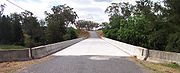
Bridges
Muswellbrook Shire Council
The dilapidated timber sections of the Kirks Bridge, crossing Baerami Creek at BaeramiBaerami, New South Wales
Baerami is a locality in New South Wales, Australia, in the Muswellbrook Shire. It is located on the Bylong Valley Way. Baerami is the site of Kirks Bridge, where the Bylong Valley Way crosses Baerami Creek....
were demolished and were planned to be replaced with new concrete sections by 31 August 2007. Unfortunately, flooding during the 2007 Hunter region and Central Coast storms delayed the work by around a month. The bridge had previously been partially rebuilt, with both buttresses and two spans at one end having been reconstructed in concrete.
Muswellbrook Shire Council maintained a temporary deviation on private property for several years to allow access during bridgework and for heavy vehicles. After the bridge was reopened, that deviation was removed and the land returned to its owner.
The single-lane timber bridge over Widden Creek is also to be replaced. Muswellbrook Shire Council had committed to spend $480,000 by 30 June 2007 to Manage the investigation, design and construction works but the discovery of a serious problem on Kirks Bridge saw that money diverted to the more urgent project. Muswellbrook Shire Council now plan to replace the Widden Creek bridge by 30 June 2009 at a cost of A$1.4 Million.
Once the Widden Creek bridge is replaced, the 38 tonne load limit will be lifted, allowing heavy vehicles to again use this route.
Mid-Western Regional Council
Mid-Western Regional council plan to replace the single lane Carwell Bridge between KandosKandos, New South Wales
Kandos is a small town in New South Wales, Australia, in the Mid-Western Regional Council. It is located on the Bylong Valley Way. At the 2006 census, Kandos had a population of 1,306 people.The main non-agricultural industry is the production of cement...
and Ilford between mid 2009 and mid 2010.
Railway
Sandy Hollow- Gulgong railway line, New South Wales
The Sandy Hollow- Gulgong railway line is a railway line in northern New South Wales, Australia. The line forms a cross country connection with the Main North line and the Gwabegar line and ultimately on to the Main West line creating a circuitous bypass of Sydney for freight traffic heading...
and part of the Merriwa railway line
Merriwa railway line, New South Wales
The Merriwa railway line is in northern New South Wales, Australia. The line branches from the Main North line at Muswellbrook and travels north through Sandy Hollow to the town of Merriwa, a distance of approximately . The line was completed to Merriwa on 29 October, 1917, however the section...
, which form the Australian Rail Track Corporation
Australian Rail Track Corporation
Australian Rail Track Corporation is a federal government owned corporation established in 1997 that owns, leases, maintains and controls the majority of main line standard gauge railway lines on the mainland of Australia, known as the Defined Interstate Rail Network .-History:The Interstate...
's Ulan line between Muswellbrook and Gulgong
Gulgong, New South Wales
Gulgong is a 19th century gold rush town in the Central-West of the Australian state of New South Wales. The town is located about north west of Sydney, and about 30 km north of Mudgee along the Castlereagh Highway. At the 2006 census, Gulgong had a population of 1,907 people...
, follow the same valleys as the Bylong Valley Way from near the Golden Highway to near Bylong, where the railway line continues west as the road turns south.
The Ulan line crosses the road three times, twice at level crossings and once on a bridge over the road. One level crossing is close to the Golden Highway while the other is close to Bylong. The railway bridge is on the western side of Coxs Gap, between the level crossings.
The Gwabegar railway line
Gwabegar railway line, New South Wales
The Gwabegar railway line is a railway line in the west of New South Wales, Australia which passes through the town of Mudgee to Gulgong and eventually heads to Gwabegar....
crosses the road on at a level crossing the northern side of Rylstone.
All three of the level crossings have flashing warning lights but not boom gates.
See also
- Highways in AustraliaHighways in AustraliaThis is a list of highways in Australia, listed alphabetically along with each highway's route number and location. Note that some highways service more than one state or territory.-Route numbering systems:...
- List of highways in New South Wales