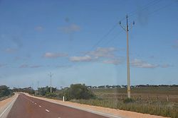
Flinders Highway, South Australia
Encyclopedia
Flinders Highway connects the South Australia
n towns of Ceduna
and Port Lincoln
, a distance of 410 kilometres. The highway was formerly designated as National Route Alternate 1 and currently signed as B100. The National Route Alternate 1 presents an alternative but somewhat longer coastal route between Port Augusta
and Ceduna, compared to the more direct Eyre Highway
.
It runs parallel to the western coasts of the Eyre Peninsula
. It is named after the explorer Matthew Flinders
who sighted these coasts in the early 19th century. Only small settlements lie along its track. Of these, Coffin Bay is a centre for oyster farming, Elliston
is renowned for surfing
and fishing
and Ceduna itself is a base for whale watching
.

South Australia
South Australia is a state of Australia in the southern central part of the country. It covers some of the most arid parts of the continent; with a total land area of , it is the fourth largest of Australia's six states and two territories.South Australia shares borders with all of the mainland...
n towns of Ceduna
Ceduna, South Australia
Ceduna is a small town in the West Coast region of South Australia. It is situated in the northwest corner of Eyre Peninsula, facing the islands of the Nuyts Archipelago. It lies west of the junction of the Flinders and Eyre Highways around 786 km northwest of the capital Adelaide. The port...
and Port Lincoln
Port Lincoln, South Australia
- Transport :Port Lincoln is the port for the isolated narrow gauge Eyre Peninsular Railway.There is also a subsidiary port at Proper Bay which may be restored to use for iron ore traffic. The export of iron ore through Port Lincoln has been approved by the South Australian Government. Port...
, a distance of 410 kilometres. The highway was formerly designated as National Route Alternate 1 and currently signed as B100. The National Route Alternate 1 presents an alternative but somewhat longer coastal route between Port Augusta
Port Augusta, South Australia
-Electricity generation:Electricity is generated at the Playford B and Northern power stations from brown coal mined at Leigh Creek, 250 km to the north...
and Ceduna, compared to the more direct Eyre Highway
Eyre Highway
The Eyre Highway is a highway linking Western Australia and South Australia via the Nullarbor Plain. Signed as National Highway 1/A1, it forms part of Highway 1 and the Australian National Highway network linking Perth and Adelaide. It was named after explorer Edward John Eyre, who was the first to...
.
It runs parallel to the western coasts of the Eyre Peninsula
Eyre Peninsula
Eyre Peninsula is a triangular peninsula in South Australia. It is bounded on the east by Spencer Gulf, the west by the Great Australian Bight, and the north by the Gawler Ranges. It is named after explorer Edward John Eyre who explored some of it in 1839-1841. The coastline was first explored by...
. It is named after the explorer Matthew Flinders
Matthew Flinders
Captain Matthew Flinders RN was one of the most successful navigators and cartographers of his age. In a career that spanned just over twenty years, he sailed with Captain William Bligh, circumnavigated Australia and encouraged the use of that name for the continent, which had previously been...
who sighted these coasts in the early 19th century. Only small settlements lie along its track. Of these, Coffin Bay is a centre for oyster farming, Elliston
Elliston, South Australia
Elliston is a small coastal town in South Australia on the west coast of Eyre Peninsula 169 km northwest of Port Lincoln and 641 km west of Adelaide. The township is located on Waterloo Bay....
is renowned for surfing
Surfing
Surfing' is a surface water sport in which the surfer rides a surfboard on the crest and face of a wave which is carrying the surfer towards the shore...
and fishing
Fishing
Fishing is the activity of trying to catch wild fish. Fish are normally caught in the wild. Techniques for catching fish include hand gathering, spearing, netting, angling and trapping....
and Ceduna itself is a base for whale watching
Whale watching
Whale watching is the practice of observing whales and other cetaceans in their natural habitat. Whales are watched most commonly for recreation but the activity can also serve scientific or educational purposes. A 2009 study, prepared for IFAW, estimated that 13 million people went whale watching...
.
Localities

- Laura Bay
- Smoky BaySmoky Bay, South AustraliaSmoky Bay is a small coastal village located on the West Coast of the Eyre Peninsula, South Australia. Previously used as a port, the town is now a residential settlement and popular tourist destination known for its recreational fishing, with a boat ramp and jetty located in the town...
- Streaky BayStreaky Bay, South AustraliaStreaky Bay is a coastal town on the western side of the Eyre Peninsula, in South Australia just off the Flinders Highway 303 km north west of Port Lincoln and 727 km by road from Adelaide...
- Port KennyPort Kenny, South AustraliaPort Kenny is a small town located on the Eyre Peninsula in South Australia. It serves as a central point for the surrounding agricultural district, as well as professional fishermen and tourists. It currently has a very small population.-History:...
- EllistonElliston, South AustraliaElliston is a small coastal town in South Australia on the west coast of Eyre Peninsula 169 km northwest of Port Lincoln and 641 km west of Adelaide. The township is located on Waterloo Bay....
- WangaryWangary, South AustraliaWangary is a town on the Eyre Peninsula in the Australian state of South Australia, located west of Port Lincoln on the Flinders Highway near Coffin Bay. At the 2006 census, Wangary had a population of 289....
- Coffin Bay (off road)

