

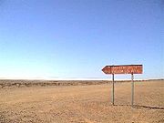
Oodnadatta Track
Encyclopedia
Australia
Australia , officially the Commonwealth of Australia, is a country in the Southern Hemisphere comprising the mainland of the Australian continent, the island of Tasmania, and numerous smaller islands in the Indian and Pacific Oceans. It is the world's sixth-largest country by total area...
is an unsealed 620 kilometre track between Marree
Marree, South Australia
Marree is a small town located in the north of South Australia. It lies North of Adelaide at the junction of the Oodnadatta Track and the Birdsville Track, above sea level. The area is the home of the Dieri people. At the 2006 census, Marree had a population of 70.The town was home to Australia's...
and Marla
Marla, South Australia
Marla is a small town on the Stuart highway in north-western South Australia. It is located near the Ghan railway line. At the 2006 census, Marla had a population of 72....
via Oodnadatta
Oodnadatta, South Australia
Oodnadatta, South Australia, is a small town surrounded by an area of with cattle stations in arid pastoral rangelands close to the Simpson Desert, north of Adelaide and 112 m above sea level. It can be reached by an unsealed road from Coober Pedy or via the unsealed Oodnadatta Track from...
in South Australia
South Australia
South Australia is a state of Australia in the southern central part of the country. It covers some of the most arid parts of the continent; with a total land area of , it is the fourth largest of Australia's six states and two territories.South Australia shares borders with all of the mainland...
. It passes the southern lake of the Lake Eyre National Park
Lake Eyre National Park
Lake Eyre National Park is located in South Australia , 697 km north of Adelaide. It contains both the North and South sections of Lake Eyre as well as sections of the Tirari Desert....
.
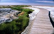
The Track follows a traditional aboriginal trading route, and provides travellers with some stunning semi-desert scenery. Along the Track are numerous springs feeding water from the Great Artesian Basin
Great Artesian Basin
The Great Artesian Basin provides the only reliable source of freshwater through much of inland Australia. The basin is the largest and deepest artesian basin in the world, stretching over a total of , with temperatures measured ranging from 30°C to 100°C...
, the most accessible examples being the mound springs found in Wabma Kadarbu Mound Springs Conservation Park near Coward Springs
Coward Springs, South Australia
Coward Springs is a former settlement and railway station in the desert in outback South Australia. It is situated on the Oodnadatta Track adjacent to the Wabma Kadarbu Mound Springs Conservation Park, 236 km from Coober Pedy....
. Later, because of the availability of water, the route was chosen for the steam-train powered Central Australian Railway, the original route of The Ghan, also the route taken by the explorer John McDouall Stuart
John McDouall Stuart
John McDouall Stuart was one of the most accomplished and famous of all Australia's inland explorers. Stuart led the first successful expedition to traverse the Australian mainland from south to north and return, and the first to do so from a starting point in South Australia, achieving this...
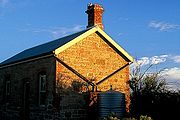
on his third expedition in 1859. Remnants of the many railway sidings and Overland Telegraph repeater stations are still along the track - some of the best preserved are the Coward Springs Campground
Coward Springs, South Australia
Coward Springs is a former settlement and railway station in the desert in outback South Australia. It is situated on the Oodnadatta Track adjacent to the Wabma Kadarbu Mound Springs Conservation Park, 236 km from Coober Pedy....
- complete with natural artesian spa and Curdimurka. Today, the Oodnadatta Track roughly follows the former railway line as far north as Oodnadatta
Oodnadatta, South Australia
Oodnadatta, South Australia, is a small town surrounded by an area of with cattle stations in arid pastoral rangelands close to the Simpson Desert, north of Adelaide and 112 m above sea level. It can be reached by an unsealed road from Coober Pedy or via the unsealed Oodnadatta Track from...
, and then turns to the west, meeting the sealed Stuart Highway at Marla. In dry weather, it is passable to most vehicles and caravans, but a 4-wheel-drive is preferable. The Track was named by Adam Plate of the Oodnadatta Progress Association Inc. in about 1980 to form a trilogy of unsealed tourist routes with the Birdsville and Strzelecki Tracks nearby.
External links
- "Tracking History to Oodnadatta" by Roderick Eime